Changing the International Territorial Level geography for Scotland: consultation
The International Territorial Levels (ITLs) are geographic boundaries used in the production of statistics in the United Kingdom. The purpose of this consultation is to seek views on proposed changes to these geographies in Scotland.
Proposed changes at ITL3
The main purpose of the proposed changes outlined in this consultation is to produce ITL regions that align with local authority boundaries and whose population falls within the recommended population constraints as far as possible. This section outlines the proposals for ITL3 geographies in greater detail.
The current definition of the ITL3 geography divides Scotland into 23 regions. We now propose to reduce the number of ITL3 regions to 18, while also aligning boundaries with local authority boundaries.
Currently 7 of the existing 23 regions have populations below the 150,000 minimum population recommended for ITL3 regions. Under the proposed changes, only three regions (Dumfries and Galloway, South Ayrshire and Scottish Borders) are below the recommended minimum population. Population tables based on National Record of Scotland mid-year population estimates for 2021 have been included in annex 1.
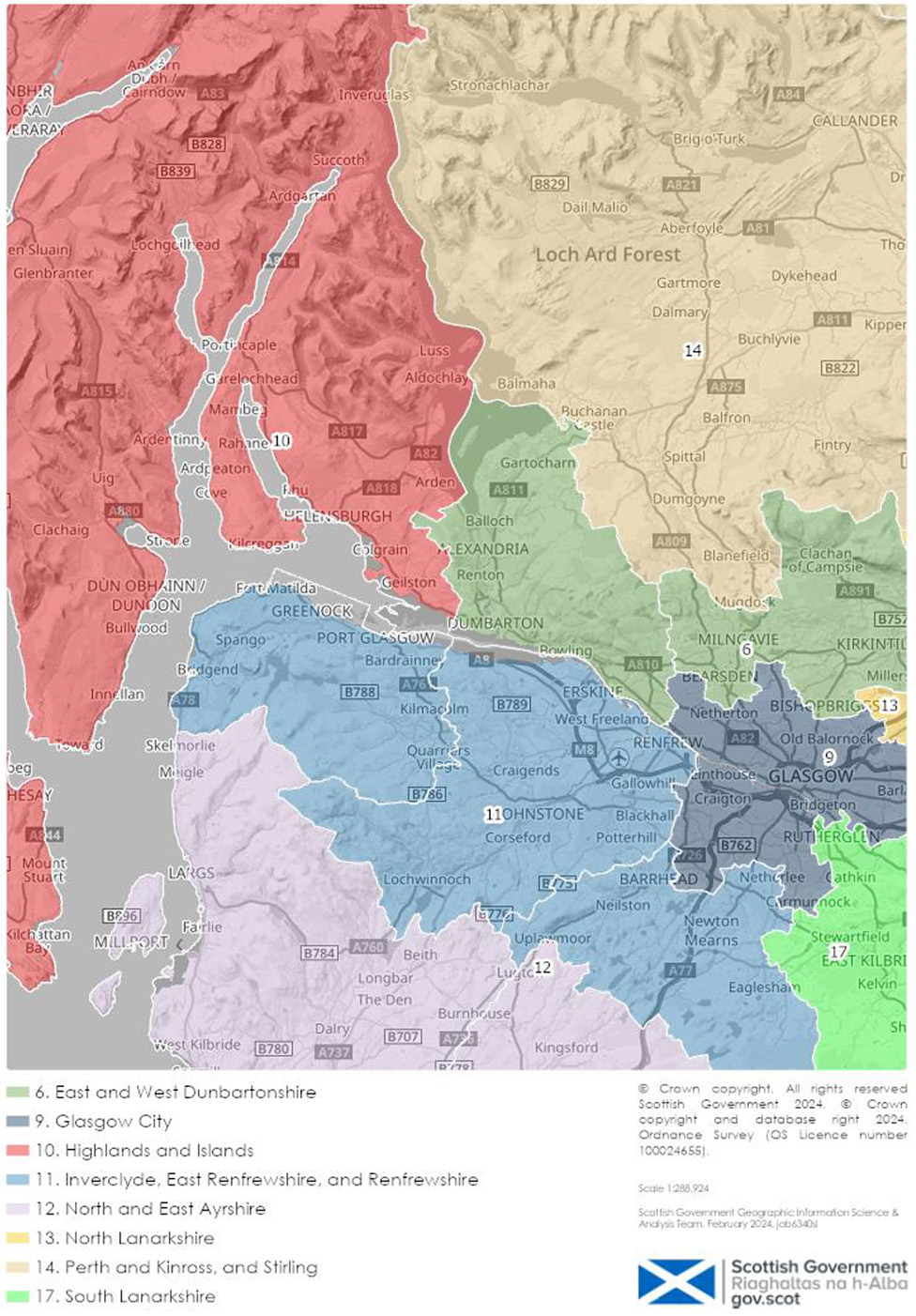
This reduction in the number of regions and rebalancing of populations has been achieved by making the following changes to ITL3 regions. The proposed new ITL3 regions are shown in Figure 4:
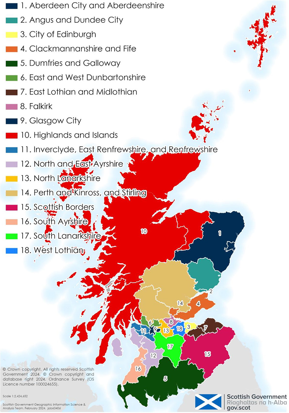
New ‘Highlands and Islands’ Region
A new ‘Highlands and Islands’ region has been created by combining six local authorities. These are Argyll and Bute, Highland, Moray, Na h-Eileanan Siar, Orkney Islands, and Shetland Islands. This effectively combines six existing ITL3 regions:
- Caithness and Sutherland, and Ross and Cromarty
- Inverness and Nairn, Moray, and Badenoch and Strathspey
- Lochaber, Skye and Lochalsh, Arran and Cumbrae, and Argyll and Bute
- Na h-Eileanan Siar
- Orkney Islands
- Shetland Islands
Five of the six ITL3 regions listed here have populations that are considerably lower than the recommended population limits for ITL3 regions of between 150,000 and 800,000. For example, the Orkney Islands had an estimated population of 22,540 in 2021. This reduces the usefulness of the ITL3 geography when making international comparisons.
It also reduces the usefulness of ITL3 as a general-purpose geography. For example, in cases where it is not possible to publish data for a small local authority such as Orkney Islands or Shetland Islands due to small sample sizes or concerns about disclosure, it will not be possible to ‘move up’ to the ITL3 level.
Combining these local authorities in this way results in a proposed Highlands and Islands Region with a population of 492,810. This figure is comfortably between the recommended population limits for ITL3 regions of between 150,000 and 800,000.
Note that the proposed ITL3 region is the same as the ‘Highlands and Islands’ ITL2 region. This will be considered further in the following section on proposed changes to ITL2.
Impact of aligning ITL3 regions with Local Authority boundaries
Aligning ITL3 regions with local authority boundaries results in some notable changes.
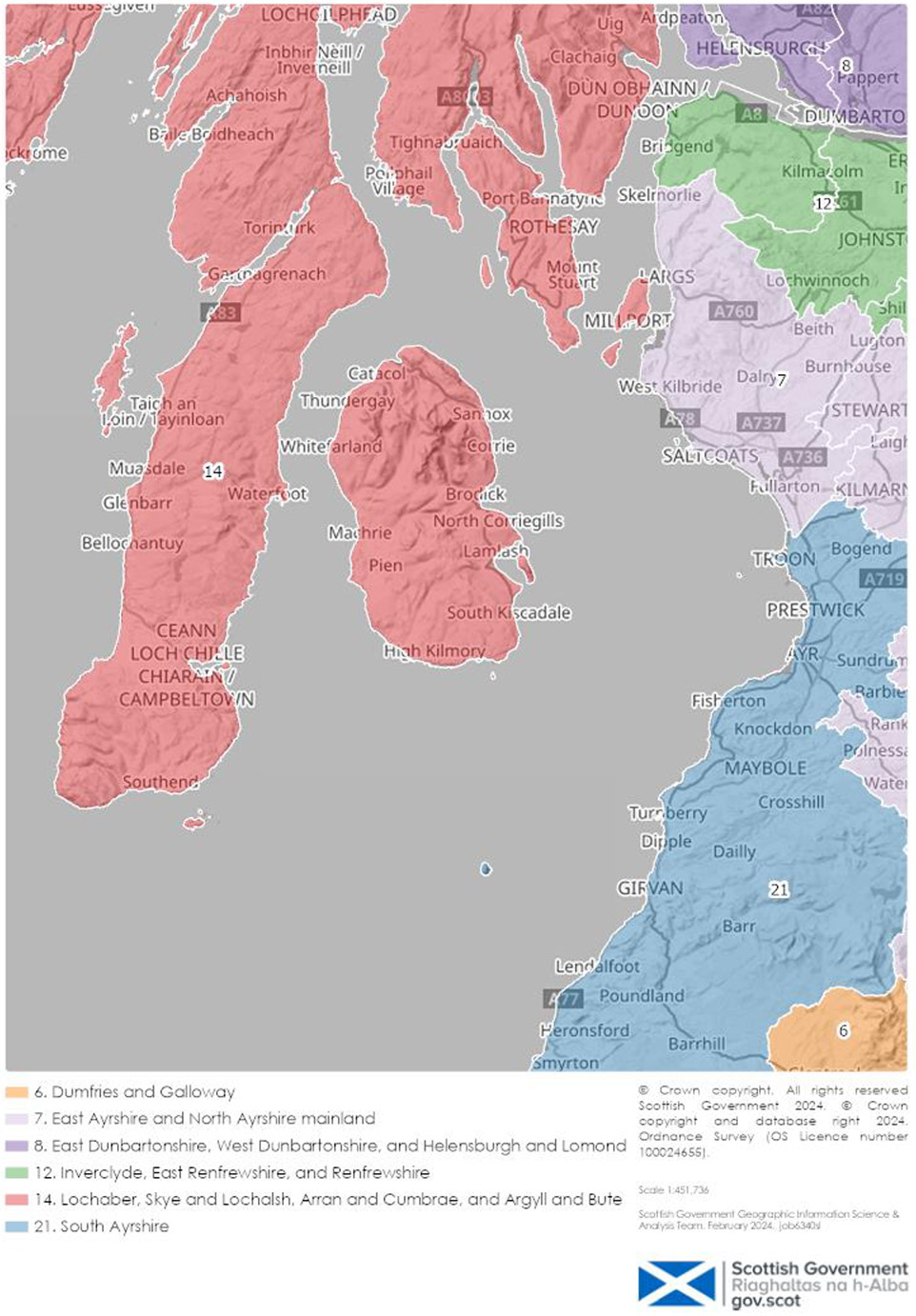
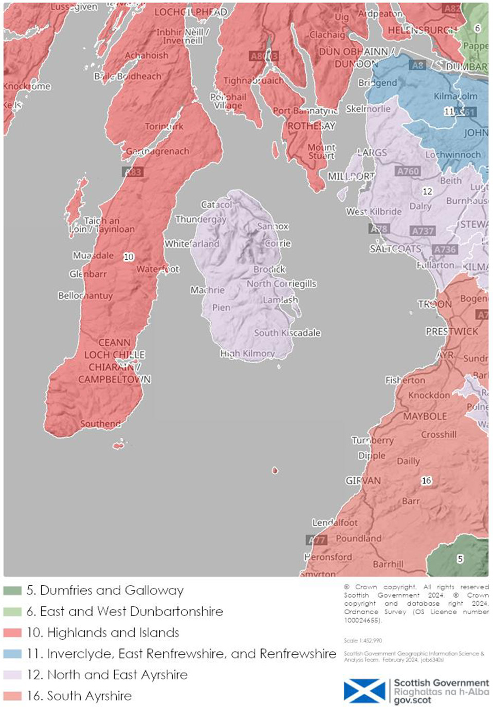
The islands of Arran, Great Cumbrae and Little Cumbrae, which are part of the North Ayrshire local authority, now become part of the proposed ‘North and East Ayrshire’ ITL3 region. Currently they belong to the ‘Lochaber, Skye and Lochalsh, Arran and Cumbrae, and Argyll and Bute’ ITL3 region.
These changes are shown in figures 5 and 6 below:
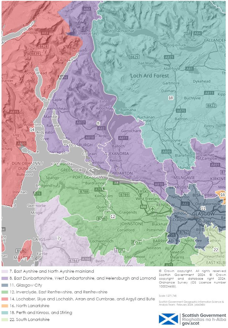
In a similar way the areas of Helensburgh and Lomond, which belong to the Argyll and Bute local authority, have moved from the existing ‘East Dunbartonshire, West Dunbartonshire, and Helensburgh and Lomond’ to the new ‘Highlands and Islands Region’. As a result, a new ‘East and West Dunbartonshire’ region is also created.
These areas are shown in Figures 7 and 8 below:
Proposals to align NUTS boundaries with local authority boundaries were previously considered as part of a consultation that took place in 2012. These proposals were rejected following consultation. Respondents to that consultation opposed the proposals in part due to concerns that Arran and Cumbrae would lose European Union funding. Following the departure of the UK from the European Union, the UK is no longer eligible for EU Structural and Investment Funds, so boundary changes will no longer impact on this funding. In addition, the UK departure from the European Union has resulted in reduced demand for ITL statistics.
Other respondents opposed the proposals on the grounds that Arran and Cumbrae should remain in the Highlands and Islands region because they are islands, and so they require policies (and statistics) that reflect this. A further reason was due to concerns that the boundaries would not align with those used by Highlands and Islands Enterprise. Others opposed the proposals on the grounds that islands and remote areas face similar economic and demographic challenges, and so require similar policies and statistics.
As discussed, we consider the advantages of aligning with local authority boundaries outweigh the disadvantages. This is because aligning ITL boundaries with local authorities will make it much easier to produce regional statistics for a wide range of topics by combining readily available statistics already produced at local authority level.
However, in some cases there may still be a strong user need for statistics to be produced for regional geographies that do not align with local authority boundaries. This might include issues of particular relevance to the islands and other remote areas.
For example, the Scottish Government already regularly produces economic statistics at a range of geographies as part of its Sub-Scotland Economic Statistics Database. In addition, the Scottish Government recently created a new Scottish Islands Regions geography to support the publication of statistics that will support the understanding of issues faced by Scotland’s islands.
To ensure that the proposed changes do not negatively impact on existing users it will be important that statistics producers, including Scottish Government and the Office for National Statistics, continue to publish statistics using alternative geographies where there is a clear user need. This might also include publishing statistics using small area geographies, such as data zones, that users can combine into higher geographies as required.
Contact
There is a problem
Thanks for your feedback