Draft Fisheries Assessment – Anton Dohrn Seamount SAC: Fisheries management measures within Scottish Offshore Marine Protected Areas (MPAs)
These assessments look at the fishing activity occurring within each offshore MPA and SAC and assess the potential impacts of this activity on the protected features within each site. This assessment is for Anton Dohrn Seamount SAC.
1. Introduction
1.1 Scope of the Anton Dohrn Seamount SAC assessment
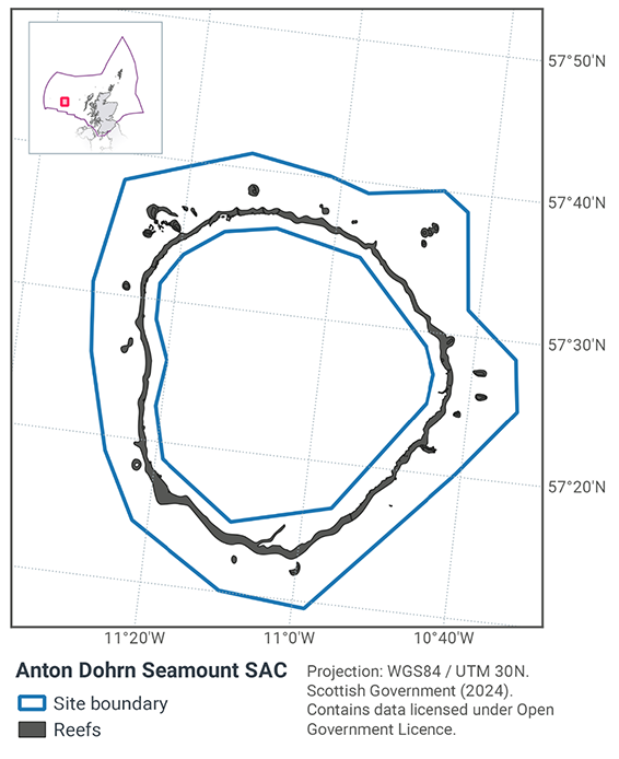
The geographic scope of this assessment covers the whole of Anton Dohrn Seamount SAC (Figure 1) in the offshore region (12-200 nautical miles, nm). The purpose of this assessment is to determine whether the current levels of fishing activity occurring within the site are compatible with the conservation objectives of the Anton Dohrn Seamount SAC and identify options for management measures.
In this assessment, Scottish Ministers use the best available evidence to review the site characteristics and current fishing activity (Part A), both taken alone and in combination with other relevant activities (Part C), to determine if there is the potential for these activities to have a likely significant effect (LSE) on the protected feature of the site (Annex I Reef). Any fishing activities with the potential for LSE, either alone or in combination with other relevant activities are considered further to assess whether they could result in an adverse effect on site integrity (Part B).
Where there is the potential for an adverse effect on site integrity, management measures are identified for the site by Scottish Ministers. These measures are considered in light of the conservation objectives, biological characteristics, and current fishing activity levels and existing fisheries restrictions for Anton Dohrn SAC. A final decision on which measures, if any, are to be adopted, will follow upon a statutory consultation exercise and will take into account all relevant statutory obligations incumbent upon Scottish Ministers.
A methodology document has been prepared to aid understanding of these assessments.
1.2 Site description
The Anton Dohrn Seamount SAC (Figure 1) is located to the west of Scotland, about 200 km from the Outer Hebrides in the central Rockall Trough. The site is located within the West of Scotland Nature Conservation Marine Protected Area. The conservation objective for the site is for the feature to be in favourable condition thus ensuring site integrity in the long term and contribution to Favourable Conservation Status of Annex I Reefs (stony, bedrock, and biogenic).
The seamount is a former volcano, roughly circular in shape. The top is fairly uniform in depth (at 1,100 m) and is interspersed with features extending to a maximum height of around 530 m below sea level. The top is surrounded by steep (20 - 50°) cliff slopes extending down towards a moat at approximately 2,400 m depth.
The upper regions of the seamount flanks are bedrock reef grading to stony reef on the lower flanks. These habitats support assemblages of holothurians (sea cucumbers), brittlestars, encrusting sponges, caryophyllid corals and lamellate sponges. At the base of the seamount flanks, bedrock, and stony reef outcrop on radial ridges and on parasitic cones, formed when volcanic material erupted from lateral vents rather than the central vent. Both these features support dense aggregations of gorgonians (sea whips or sea fans) and other corals. Biogenic reef, in the form of live cold-water coral reef (Lophelia pertusa), occurs on the top of small mounds which are located along the edge of the cliff.
JNCC’s view in 2020 on the overall condition of the site’s qualifying feature is that it is in unfavourable condition and therefore needs to be restored to favourable condition.
The Conservation Objectives for the Annex I Reef at Anton Dohrn Seamount SAC are:
Subject to natural change, maintain or restore reef in/to favourable condition, such that:
- The extent and distribution of the qualifying habitat in the site;
- The structure and function of the qualifying habitat in the site; and
- The supporting processes on which the qualifying habitat relies
are maintained or restored, thereby ensuring the integrity of the site and also making an appropriate contribution to favourable condition status of the Annex I habitats (see Relevant Documentation & Conservation Advice 2020).
Further information regarding the designation and conservation objectives for the protected features of Anton Dohrn Seamount SAC is available on the JNCC Anton Dohrn Seamount SAC webpage.
1.3 Activities assessed
The process followed to conduct this ‘Fisheries Assessment’ is in line with the process for a Habitats Regulation Appraisal, as required under Article 6(3) of Council Directive 92/43/EEC of 21 May 1992 on the conservation of natural habitats and of wild fauna and flora (the Habitats Directive); for sites within the offshore region under Regulation 28 of the Conservation of Offshore Marine Habitats and Species Regulations 2017.
In this context, fishing activity within the SAC is considered to be the plan or project, and the implications of the fishing activity in view of the conservation objectives for the SAC are being assessed through the fisheries screening stage (Part A), the fisheries assessment (Part B), and the in combination (cumulative effect) assessment (Part C).
Fisheries assessments use the best available evidence to fully consider potential impacts of commercial fishing activity, and in-combination (cumulative) effects with other plans and projects, against the conservation objectives for the site. If the assessment concludes that use of certain fishing gear types is not compatible with the conservation objectives of the site, management measures will be considered.
Commercial sea fishing activity has the potential to vary in nature and intensity over time. This assessment considers fishing activity based on activity levels and type between 2015-2019. This date range was considered to provide the best available data on current fishing activity levels for the assessment. Using a five year date range provides an average view of fishing activity within the site; latter years (2020 – 2021) were not considered representative of regular fishing activity due to the Covid pandemic. The selected date range (2015 – 2019) was used consistently across all assessments within the consultation package. Changes in fishing activity after this time period may be considered in future reviews of this assessment (see Section 6).
Contact
Email: marine_biodiversity@gov.scot
There is a problem
Thanks for your feedback