Draft Fisheries Assessment – Central Fladen NCMPA: Fisheries management measures within Scottish Offshore Marine Protected Areas (MPAs)
These assessments look at the fishing activity occurring within each offshore MPA and SAC and assess the potential impacts of this activity on the protected features within each site. This assessment is for Central Fladen NCMPA.
3 Part B Assessment – Fisheries Assessment
3.1 Fisheries assessment overview
Part B of this assessment considers if there would be a risk of the fishing activities identified in Part A, at the levels identified in the relevant date range, hindering the achievement of the conservation objectives for the MPA, in order to consider whether, and if so, which, management measures might be appropriate for the MPA, taking into account all relevant statutory obligations incumbent upon the Scottish Ministers.
The fishing activities identified in Part A which have been included for assessment in Part B are demersal trawls and demersal seines. The pressures associated with these fishing activities that have been included in Part B are abrasion/disturbance of the substrate on the surface of the seabed; penetration and/or disturbance of the substrate below the surface of the seabed, including abrasion; removal of target species and removal of non-target species.
3.2 Fishing activity descriptions
3.3 Existing management within Central Fladen NCMPA
Within a small central portion of the site there are seasonal fishing restrictions through the North Sea cod avoidance measures for Long Hole, to protect spawning areas. This consists of prohibitions on gillnets, creels, static hooks, bottom trawling and dredging, as well as fishing by hand, between January to April. This management area overlaps with the geomorphological feature within the site.
3.4 Fishing activity within Central Fladen NCMPA
The Central Fladen NCMPA overlaps ICES rectangles 46E9, 46F0 and 47E9 in the Northern North Sea (ICES Division 4a), in the Fladen region. The predominant fish species landed are mackerel, herring and cod. The main gear types for UK vessels are midwater trawls and demersal trawls. All landings are from over-12 m vessels; there are no recorded landings by under-12 m vessels from these rectangles.
VMS-based estimates and ICES rectangle landings statistics indicate that over-12 m demersal trawls and midwater trawls are the predominant UK vessels that operated within the site over the period 2015-2019.
For the over-12 m vessels, based on VMS data from 2015-2019, demersal trawls operate intensively throughout the site, but with a slightly higher frequency in the central and northern areas. Midwater trawls are recorded across the site but in relatively low frequency, with demersal seines concentrated in the southern part of the site.
In addition to UK activity, vessels from Norway (128 vessels), Denmark (55 vessels), Sweden (11 vessels), Germany (10 vessels), France (9 vessels), Netherlands (8 vessels), Faroes, Ireland and Lithuania (number of vessels cannot be disclosed) may also operate in the site, based on VMS data from 2015-2020. However, it is not clear what gear types these vessels operate, nor whether they were actively fishing at the time.
3.5 Demersal trawls
The aggregated gear method of demersal trawls includes multiple gears that operated within the Central Fladen NCMPA between 2015 and 2019. These include bottom otter trawls, multi-rig trawls, pair trawls, nephrops trawls and other not specified bottom trawl types (Table 1). The target species for these gear types are demersal fish, molluscs and nephrops. Similar pressures are exerted by the different gears used for demersal trawling, subsequently the aggregated gear type of ‘demersal trawl’ was used to map activity across the site.
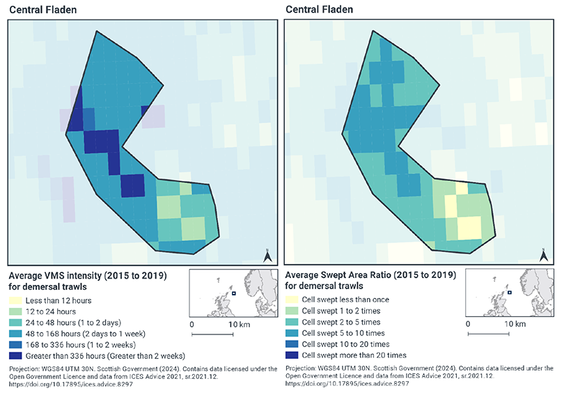
Based on the VMS, the highest intensity of demersal trawl activity (greater than 336 hours per year per grid cell between 2015-2019) within Central Fladen NCMPA occurs in a central belt along the middle of the site, coinciding with the deepest waters within the geomorphological glacial trough feature (Figure 1). The lowest activity occurs in the south-east corner of the site (Figure 2), whilst the remainder of the site has a moderate level of fishing intensity (48-168 hours per year per grid cell between 2015-2019).
Swept-Area Ratio (SAR) information averaged over the same time period shows that some areas within the south-east of the site were swept only once, or one to two times per year per grid cell, between 2015-2019 (Figure 2). The rest of the site was swept 2-5 times, whilst the central zone shows a similar pattern to the VMS data whereby the greatest SAR values occur (swept 5-10 times).
The area of concentrated demersal trawl activity corresponds with the geomorphological glacial trough feature within the site, whilst the lowest levels of activity and the moderate levels of activity overlap with the burrowed mud feature.
3.6 Demersal seines
Only one demersal seine gear type operated within the Central Fladen NCMPA between 2015 and 2019 (Table 1), which was Scottish fly/seine. The target species for this gear type is demersal fish.
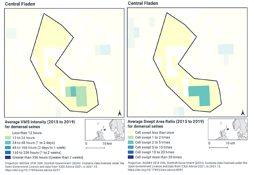
Based on the VMS, demersal seine activity within Central Fladen NCMPA is dispersed throughout the site but mainly occurs at fairly low levels (less than 12 hours of activity per year per grid cell between 2015-2019) (Figure 3). The south-east corner of the site however has higher levels of activity, peaking at 24-48 hours per year per grid cell between 2015-2019 (Figure 3).
Swept-Area Ratio (SAR) information averaged over the same time period shows similar patterns of fishing intensity as the VMS data (Figure 3), with areas of low fishing intensity dispersed throughout the site, which were swept only once per year per grid cell between 2015-2019. The south-east corner of the site shows similar higher levels of activity, like the VMS, where SAR ratios show that the areas were swept two to five times between 2015-2019.
The area of concentrated demersal seine activity overlaps with part of the burrowed mud feature within the site (Figure 1).
3.7 Summary of fishing activity within Central Fladen NCMPA
Fishing activities using demersal trawls and demersal seines, all occur within the Central Fladen NCMPA.
The most common fishing activity within Central Fladen NCMPA is demersal trawling, which occurs throughout the site, but is concentrated in the centre, where the geomorphological glacial trough feature occurs.
Demersal seines are similarly widespread in their distribution over the site, however the highest levels of intensity occurs in the south-east corner of the site, overlapping the burrowed mud feature, where there are examples of the tall seapen occurring.
3.8 Fishing activity effects overview
The following sections explore the pressures associated with fishing activity (demersal trawls and demersal seines) within the Central Fladen NCMPA that were considered capable of affecting the burrowed mud feature. The pressures considered in the following sections are:
- Abrasion/disturbance of the substrate on the surface of the seabed;
- Penetration and/or disturbance of the substrate below the surface of the seabed, including abrasion;
- Removal of non-target species; and
- Removal of target species.
All four pressures, as exerted by demersal trawl and demersal seines were considered capable of affecting the burrowed mud feature.
Given the similarity between ‘abrasion/disturbance of the substrate on the surface of the seabed’ and ‘penetration and/or disturbance of the substrate below the surface of the seabed’, these two pressures are considered together in the text below.
In the absence of a detailed JNCC Advice on Operations spreadsheet for this site, the detailed pressure information for this section is based on information from the Management Options Paper for Central Fladen NCMPA (2014), JNCC PAD and FeAST.
3.9 Summary of impacts associated with demersal mobile gear (demersal trawls and seines) on burrowed mud feature
Studies have shown that areas of burrowed mud subject to mobile fishing activity support a modified biological community with lower diversity, reduction or loss of long-lived filter-feeding species and increased abundance of opportunistic scavengers (Ball et al., 2000; Tuck et al., 2000). This effect was greatest in the more heavily fished offshore areas suggesting that impact is related to the intensity of fishing (Ball et al., 2000). Furthermore, modelling studies suggest that the greatest impact is produced by the first pass of a trawl (Hiddink et al., 2006). The sea pen Virgularia mirabilis does not appear to be negatively affected by trawling at low levels, possibly as a result of its ability to withdraw into the sediment, however Funiculina quadrangularis has no such ability and its distribution in Scottish waters may have been reduced as a result of nephrops trawling (Hughes, 1998). Nephrops may be an important component of the benthic community so fisheries that greatly alter its abundance or size composition may be seen to have a negative impact. Further, damage to sea pen species is likely to take place as a result of greater sediment disturbance as a result of towed demersal gear.
The JNCC and NatureScot Fisheries Management Guidance document for burrowed mud, inshore deep mud with burrowing heart urchins and offshore deep-sea muds states that if habitats have been impacted by fishing, reduction in effort may be required to allow recovery to favourable condition. However, the degree of reduction that will be required is unknown and further studies or “adaptive” management will be required to establish this. There is risk that cumulative effects of ongoing fishing may result in increasing degrees of modification. Consideration should be given to spatial and/or temporal measures as a mechanism to manage fishing intensity.
VMS data shows that the highest levels of demersal trawling takes place in the central area of Central Fladen NCMPA, which is where the geomorphological glacial trough feature occurs. The rest of the site has moderate levels of demersal trawling activity, which overlaps with the burrowed mud feature.
VMS data shows that low levels of demersal seining takes place across Central Fladen NCMPA, with only a small area of slightly higher intensity activity in the south-east corner of the site. At current levels of activity, it is therefore thought that this activity would not hinder the achievement of the conservation objectives.
There is a risk that surface abrasion and sub-surface penetration caused by demersal trawls may not help the achievement of the conservation objectives for burrowed mud. Therefore, demersal trawls are likely to have negative impacts on biological communities across the Central Fladen NCMPA and are not considered compatible with restoring the biological communities of the burrowed mud feature.
Use of demersal trawls may impact the physical and biological structure of the burrowed mud feature via direct physical impacts from gear interacting with the seabed and species. This may impact the extent and distribution regarding large-scale topography, sediment composition and biological assemblages.
Given the evidence above, the impacts from demersal trawling alone within Central Fladen NCMPA at current levels of activity has the potential to hinder the conservation objectives of the burrowed mud feature, such that the extent and distribution, structure and function and supporting processes are restored. Accordingly Scottish Ministers conclude that demersal trawls alone are capable of affecting the protected feature (other than insignificantly) and are not compatible with the conservation objectives of the site at current levels of activity.
Given the evidence above, the impacts from demersal trawling alone within Central Fladen NCMPA at current levels of activity carry a risk of hindering the conservation objectives for the burrowed mud feature, such that the extent and distribution, structure and function and supporting processes are restored. Accordingly, Scottish Ministers conclude that demersal trawls alone are capable of impacting the protected feature and, at current levels, would or might hinder the conservation of objectives of the MPA.
Given the evidence above, the impacts from demersal seines alone within Central Fladen NCMPA at current levels of activity would not hinder achieving the conservation objectives of the burrowed mud feature, such that the extent and distribution, structure and function and supporting processes are restored. Accordingly, Scottish Ministers conclude that demersal seines alone are capable of impacting the designated feature but would not hinder the achievement of the conservation objectives of the site at current levels of activity.
3.10 Part B conclusion
The assessment of the impact of fishing pressures at current activity levels on burrowed mud in Central Fladen NCMPA has indicated that demersal trawling activities would or might hinder the achievement of the conservation objectives for the site. As such Scottish Ministers conclude that management measures to restrict demersal trawls are required within Central Fladen NCMPA. Section 5 contains further details on potential measures.
Scottish Ministers conclude that demersal seines activities, when considered in isolation and at current levels, will not hinder the achievement of the conservation objectives for Central Fladen NCMPA.
Contact
Email: marine_biodiversity@gov.scot
There is a problem
Thanks for your feedback