Draft Fisheries Assessment – Darwin Mounds SAC: Fisheries management measures within Scottish Offshore Marine Protected Areas (MPAs)
These assessments look at the fishing activity occurring within each offshore MPA and SAC and assess the potential impacts of this activity on the protected features within each site. This assessment is for Darwin Mounds SAC.
2. Part A Assessment – fisheries screening
2.1 Fisheries screening overview
Part A of this assessment meets the ‘likely significant effect (LSE)’ test under Article 6(3) of Council Directive 92/43/EEC of 21 May 1992 on the conservation of natural habitats and of wild fauna and flora (the Habitats Directive); for sites within the offshore region under Regulation 28 of the Conservation of Offshore Marine Habitats and Species Regulations 2017. The test for likely significant effect under Regulation 28(2)(b) of the Conservation of Offshore Marine Habitats and Species Regulations 2017 is not required for activities which are directly connected with or necessary to the management of the site. Fishing activities are not considered to be directly connected with or necessary to the management of the site unless otherwise indicated.
In line with the guidance within EU Commission guidance on the Assessment of plans and projects significantly affecting Natura 2000 sites; a methodological guidance on the provisions of Article 6 (3) and (4) of the Habitats Directive 92/43/EEC, this assessment considers an LSE as any effect that may reasonably be predicted as a consequence of a plan or project that would negatively and significantly affect the conservation objectives established for the designated habitats and species of the protected area. If any likely significant effect of a plan or project cannot be excluded beyond reasonable doubt, then a full appropriate assessment should be undertaken.
In Part A of this assessment the pressure-feature interactions were assessed to determine the potential for LSE and risk to the conservation objectives. This section looks at the pressures exerted by the fishing activity occurring in the site (within the assessment period) in relation to the sensitivities of the protected features. The potential for an LSE was identified where there was both a medium-high risk of a pressure arising from the fishing activity and if any of the features were considered sensitive to that pressure. These pressure-features interactions were then taken forward to the appropriate assessment stage (Part B) to determine whether the plan or project would have an adverse impact on site integrity. For each activity assessed in Part A, there were three possible outcomes for each identified pressure-feature interaction:
For each activity assessed in Part A, there were two possible outcomes for each identified pressure-feature interaction:
1. The pressure-feature interactions were not included for Part B:
a. If the feature is not exposed to the pressure, and is not likely to be in the future; or
b. If the effect/impact of the pressure is not likely to be significant.
2. The pressure-feature interactions were included for assessment in Part B:
a. If the feature is exposed to the pressure, or is it likely to be in the future; and
b. If the potential scale or magnitude of any effect is likely to be significant; or
c. If it is not possible to determine whether the magnitude of any effect is likely to be significant.
Part B of the assessment aligns with the requirements for an Appropriate Assessment under the Conservation of Offshore Marine Habitats and Species Regulations 2017 (as amended) and considers the potential impact to site integrity by assessing the impact of fishing gears identified in Part A. This involves determining the potential level of interaction between the feature and the fishing activity, assessing the potential impact on the feature, and subsequently if fishing activities are liable to affect the conservation objectives of the site and thus the integrity of the site
This involves determining the level of interaction between the feature and the fishing activity, assessing the potential impact on the feature, and subsequently if fishing activities are liable to affect the conservation objectives of the site and thus the integrity of the site (as amended) and considers the potential impact to site integrity by assessing the impact of fishing gears identified in Part A. This involves determining the level of interaction between the feature and the fishing activity, assessing the potential impact on the feature, and subsequently if fishing activities are liable to affect the conservation objectives of the site and thus the integrity of the site.
Consideration of exposure to and the effect of a pressure on a protected feature of the SAC includes the consideration of exposure to and the effect of that pressure on any ecological or geomorphological process on which the conservation of the protected feature is wholly or in part dependant.
The JNCC Advice package (JNCC, 2018) and Advice on Operations (JNCC, 2018) has been used to inform this assessment. This is the most recent assessment package available.
2.2 Activities taking place within Darwin Mounds SAC
To screen out fishing activities that were not taking place within the site or likely to take place in the future, vessel monitoring system (VMS) data within Darwin Mounds SAC from 2015 – 2019 were analysed to identify the gear types being used in the site and the aggregated gear method. The data shows that the only form of fishing activity taking place within this this is mid-water trawl, which has been classed as Pelagic fishing.
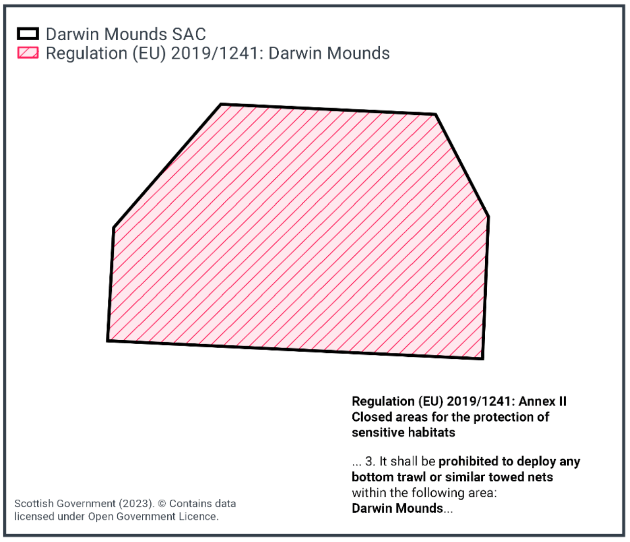
Existing management measures in place (Figure 2) within Darwin Mounds SAC were implemented through the technical regulations process. An emergency fisheries closure for demersal towed gear under Regulation (EC) 602/2004 was introduced at the site in August 2003 to protect deep-water coral reefs. In March 2004, this became a permanent fisheries closure for demersal towed gear and has since been implicitly repealed and replaced by an SAC designation in 2015 and Regulation (EU) 2019/1241, protecting sensitive habitats including vulnerable marine ecosystems (VMEs). This regulation prohibits the deployment of any bottom trawl or similar towed nets across the full area of the site.
2.3 Potential Pressures exerted by site fishing activity on protected features
Pelagic fishing, in particular mid-water trawl, whilst occurring in the site do not contact the seabed. Accordingly, as per the JNCC Advice on Operations Workbook V1.0, pelagic mid-water trawl fishing has been classified as not relevant to the protected features within the site. This has been established using best available evidence which indicates there is no interaction of concern between the pressure and the feature or the activity and the feature could not interact. As a result, pelagic gear is not considered further in this assessment.
No other fishing activities have been identified taking place within the site during the assessment period (2015-2019).
2.4 Part A Conclusion
Considering the information on pressures and sensitivity above, and guidance within the EU Commission guidance on the Assessment of plans and projects significantly affecting Natura 2000 sites; a methodological guidance on the provisions of Article 6 (3) and (4) of the Habitats Directive 92/43/EEC in relation to European Sites, and the absence of any fisheries activity which may interact with the protected features of Darwin Mounds SAC, Scottish Ministers conclude there is no fishing activities occurring which have the potential for LSE to the protected features. Therefore no further assessment through Part B (fisheries assessment) and Part C (in-combination) is required.
Contact
Email: marine_biodiversity@gov.scot
There is a problem
Thanks for your feedback