Draft Fisheries Assessment – East of Gannet and Montrose Fields NCMPA: Fisheries management measures within Scottish Offshore Marine Protected Areas (MPAs)
These assessments look at the fishing activity occurring within each offshore MPA and SAC and assess the potential impacts of this activity on the protected features within each site. This assessment is for East of Gannet and Montrose Fields NCMPA.
1. Introduction
1.1 Scope of the East of Gannet and Montrose Fields NCMPA Assessment
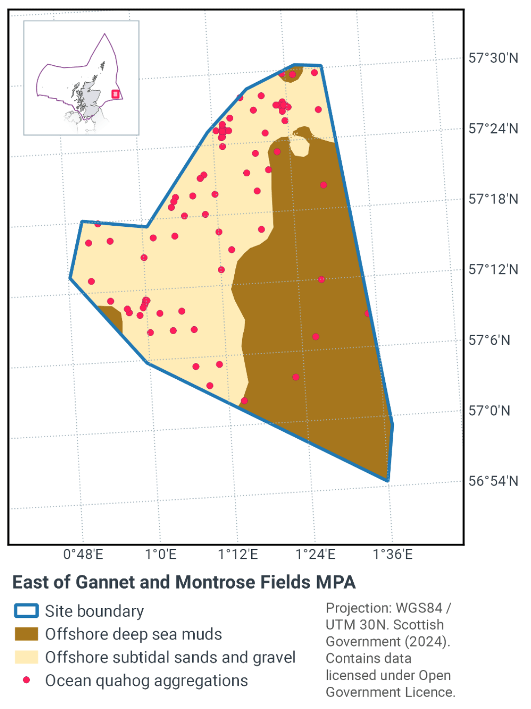
The geographic scope of this assessment covers the whole of the East of Gannet and Montrose Fields NCMPA(Figure 1). The purpose of this assessment is to determine whether the current levels of fishing activities would or might hinder the conservation objectives of East of Gannet and Montrose Fields NCMPAand to identify options for management measures.
In this assessment, Scottish Ministers use the best available evidence to review the site characteristics and current fishing activity (Part A), both taken alone and in combination with other relevant activities (Part C) to determine if the fishing activities are capable of affecting the protected features (offshore deep-sea muds, ocean quahog aggregations, offshore subtidal sands and gravels). Any fishing activities capable of affecting the protected features, either alone or in combination with other relevant activities, are considered further to assess whether they would or might hinder the achievement of the conservation objectives (Part B).
Where there is the potential for the achievement of the conservation objectives to be hindered, management measures are identified for the site by Scottish Ministers. These measures are considered in light of the conservation objectives, biological characteristics, current fishing and other activity levels and existing fisheries restrictions for East of Gannet and Montrose Fields NCMPA, as well as from the results of discussions through stakeholder workshops. A final decision on which measures, if any, are to be adopted, will follow upon a statutory consultation exercise and will take into account all relevant statutory obligations incumbent upon Scottish Ministers.
A methodology document has been prepared to aid understanding of these assessments.
1.2 Site description
The East of Gannet and Montrose Fields NCMPA (Figure 1) lies within a shallow sediment plain to the east of Scotland. The sandy seabed provides an ideal home for ocean quahog, a species of thick shelled clam that lives buried in the sand. The southern part of the NCMPA includes one of very few examples of offshore deep-sea mud on the shelf in the North Sea outside of the Fladen Grounds. The area of the East of Gannet and Montrose Fields NCMPA is approximately 1,839 km2.
The East of Gannet and Montrose Fields NCMPA is comprised mainly of sand and gravel habitats that support a range of benthic species. One such species is the ocean quahog (Arctica islandica), which are considered Threatened and/or Declining across the North-east Atlantic by the OSPAR Commission. This species of clam is typically found beneath the surface of sandy sediments, in water depths from 4 m to over 400 m. Ocean quahog filter food from passing currents and use their shovel-like ‘foot’ to bury into the sediment. Ocean quahog are an important food source for several species of fish, including cod, and can live buried deep in the sand for long periods of time without food or oxygen to escape predators. They can live for more than 400 years and are one of the longest living creatures on Earth.
The NCMPA also protects the full extent of an area of offshore deep sea mud. Muddy sediments develop in low-energy environments and species found in such habitats are adapted to life in relatively low-oxygen environments. Deep-sea muds support diverse communities including species such as nephrops, polychaete worms, bivalve molluscs, brittlestars, foraminifera and seapens. By protecting the full extent of the deep-sea mud in this area, the NCMPA protects a coherent, rather than fragmented, example of this habitat. This is one of the few examples of Atlantic-influenced offshore deep-sea mud habitats on the continental shelf in the region. Furthermore, East of Gannet and Montrose Fields NCMPA is the only NCMPA designated in the northern North Sea region for the protection of offshore deep-sea muds. The deep-sea muds occur in a 2-7 km wide band from the south east to the north west of the NCMPA, approximately 100 m deep.
The East of Gannet and Montrose Fields NCMPA has been designated for the following protected features:
- Offshore deep-sea muds
- Ocean quahog aggregations
- Offshore subtidal sands and gravels (representing sediment types suitable for ocean quahog colonisation)*
*The protection of ocean quahog requires the protection of its supporting habitat; certain types of offshore subtidal sands and gravels. Protection of this habitat will be focused on that required to sustain the ocean quahog (e.g. minimising the alteration of local habitat type in the region) rather than on conserving the range of species associated with offshore subtidal sand and gravel habitats per se.
The conservation objectives for the designed features in the East of Gannet and Montrose Fields are that the protected features so far as already in favourable condition, remain in such condition; and so far as not already in favourable condition, be brought into such condition, and remain in such condition.
With respect to the offshore deep-sea muds within the NCMPA, this means that:
- its extent is stable or increasing; and
- its structures and functions, its quality, and the composition of its characteristic biological communities are such as to ensure that it is in a condition which is healthy and not deteriorating.
With respect to the Ocean quahog aggregations (including supporting sedimentary habitats), this means that the quality and quantity of its habitat and the composition of its population in terms of number, age and sex ratio are such as to ensure that the population is maintained in numbers which enable it to thrive. Any temporary reduction of numbers is to be disregarded if the population is sufficiently thriving and resilient to enable its recovery. Any alteration to that feature brought about entirely by natural processes is to be disregarded.
For offshore deep-sea muds, and ocean quahog, the feature condition has been assessed by JNCC as being ‘Unfavourable’. More information regarding the Designation Orders for the East of Gannet and Montrose Fields NCMPA is available in the Designation Order. More information regarding the conservation objectives for the protected features of East of Gannet and Montrose Fields NCMPA is available within the site’s conservation advice package available on JNCC’s site information centre.
1.3 Activities assessed
The assessments consider the impacts of fisheries activities at each NCMPA in terms of the conservation objectives stated for the designated sites. This was deemed appropriate, in order to assist in identifying potential management measures.
In this context, the implications of the fishing activity in view of the conservation objectives for the NCMPA are being assessed through the fisheries screening stage (Part A), the fisheries assessment (Part B), and the in combination (cumulative effect) assessment (Part C).
Fisheries assessments use the best available evidence to fully consider potential impacts of commercial fishing activity, and in-combination (cumulative) effects with other activities, against the conservation objectives for the site. If the assessment concludes that use of certain fishing gear types would or might hinder the achievement of the conservation objectives of the site, management measures will be considered.
Commercial sea fishing activity has the potential to vary in nature and intensity over time. This assessment considers fishing activity based on activity levels and type between 2015-2019. This date range was considered to provide the best available data on current fishing activity levels for the assessment. Using a five year date range provides an average view of fishing activity within the site; the years 2020 – 2021 were not considered representative of regular fishing activity due to the Covid pandemic. The selected date range (2015 – 2019) was used consistently across all assessments within the consultation package. Changes in fishing activity after this time period may be considered in future reviews of this assessment (see Section 6).
Contact
Email: marine_biodiversity@gov.scot
There is a problem
Thanks for your feedback