Draft Fisheries Assessment – East of Gannet and Montrose Fields NCMPA: Fisheries management measures within Scottish Offshore Marine Protected Areas (MPAs)
These assessments look at the fishing activity occurring within each offshore MPA and SAC and assess the potential impacts of this activity on the protected features within each site. This assessment is for East of Gannet and Montrose Fields NCMPA.
3. Part B Assessment – Fisheries Assessment
3.1 Fisheries assessment overview
Part B of this assessment considers if there would be a risk of the fishing activities identified in part A, at the levels identified in the relevant date range, hindering the achievement of the conservation objectives for the MPA. This is in order to consider whether, and if so, which, management measures might be appropriate for the MPA, taking into account all relevant statutory obligations incumbent upon the Scottish Ministers.
The fishing activities and pressures identified in Part A which have been included for assessment in Part B are demersal trawls and demersal seines, and the pressures abrasions/disturbance of the substrate on the surface of the seabed; penetration and/or disturbance of the substate below the surface of the seabed, including abrasion; Removal of non-target species and Smothering and siltation rate changes (light).
3.2 Fishing Activity descriptions
3.2.1 Existing management within East of Gannet and Montrose Fields NCMPA
No existing fisheries restrictions were identified for the site.
3.2.2 Fishing activity within the NCMPA
The East of Gannet and Montrose Field NCMPA overlaps ICES rectangles 42F1, 43F0, 43F1, 44F1 which cross the Central North Sea (ICES Division 4b) and Northern North Sea (ICES Division 4a), in the Forties and Fladen regions. The main gear types for UK vessels are demersal trawls.
The VMS-based estimates and ICES rectangle landings statistics indicate that over-12 m demersal trawls are the predominant UK vessels that operated within the site over the period 2015-2019.
For the over-12 m vessels, based on the VMS data from 2015-2019, demersal trawls operate throughout the site, but with a high frequency area in the south eastern part of the site. Midwater trawls are also recorded predominantly in this particular area, however as pelagic fishing (mid-water trawls) is not considered capable of affecting the protected features of East of Gannet and Montrose Fields NCMPA this is not considered further. A small amount of demersal seine activity is recorded to take place in the north of the site.
In addition to UK activity, vessels from Norway (9 vessels), Denmark (6 vessels), Netherlands, Germany, Ireland, France and Sweden (number of vessels cannot be disclosed) may also operate in the site, based on the VMS data from 2015-2019. However, it is not clear what gear types these vessels operate, nor whether they were actively fishing at the time.
3.2.3 Demersal trawls
The aggregated gear method of demersal trawls includes multiple gears that operated within the East of Gannet and Montrose Fields NCMPA between 2015 and 2019. These include bottom otter trawls, multi-rig trawls, pair trawls, and other not specified bottom trawl types (Table 1). The target species for these gear types are demersal fish and molluscs. Similar pressures are exerted by the different gears used for demersal trawling, subsequently the aggregated gear type of ‘demersal trawl’ was used to map activity across the site.
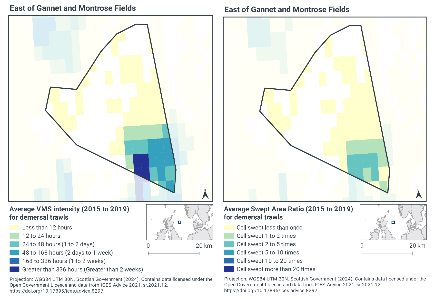
Based on the VMS data, the highest intensity of demersal trawl activity within East of Gannet and Montrose Fields occurs within the south east corner of the site, with activity peaking at greater than 336 hours per year per grid cell between 2015-2019 (Figure 2). The remainder of the site has lower fishing intensity (less than 12 fishing hours per year per grid cell).
Swept-Area Ratio (SAR) information averaged over the same time period shows similar patterns of fishing intensity as the VMS data. The south west corner of the site has the highest SAR values, suggesting grid cells in the area being swept up to 5-10 times per year between 2015-2019 (Figure 2). The rest of the site had low SAR values (cells swept less than once per year).
The area of concentrated demersal trawl activity corresponds to the area of Offshore deep-sea mud within the site (Figure 1 and Figure 2).
3.2.4 Demersal seines
The aggregated gear method of demersal seine included two types of gears that operated within the East of Gannet and Montrose Fields NCMPA between 2015 and 2019; anchor seines and Scottish fly/seine (Table 1). The target species for this gear type is demersal fish. Similar pressures are exerted by the different gears used for demersal seines, subsequently the aggregated gear type of ‘demersal seines’ was used to map activity across the site.
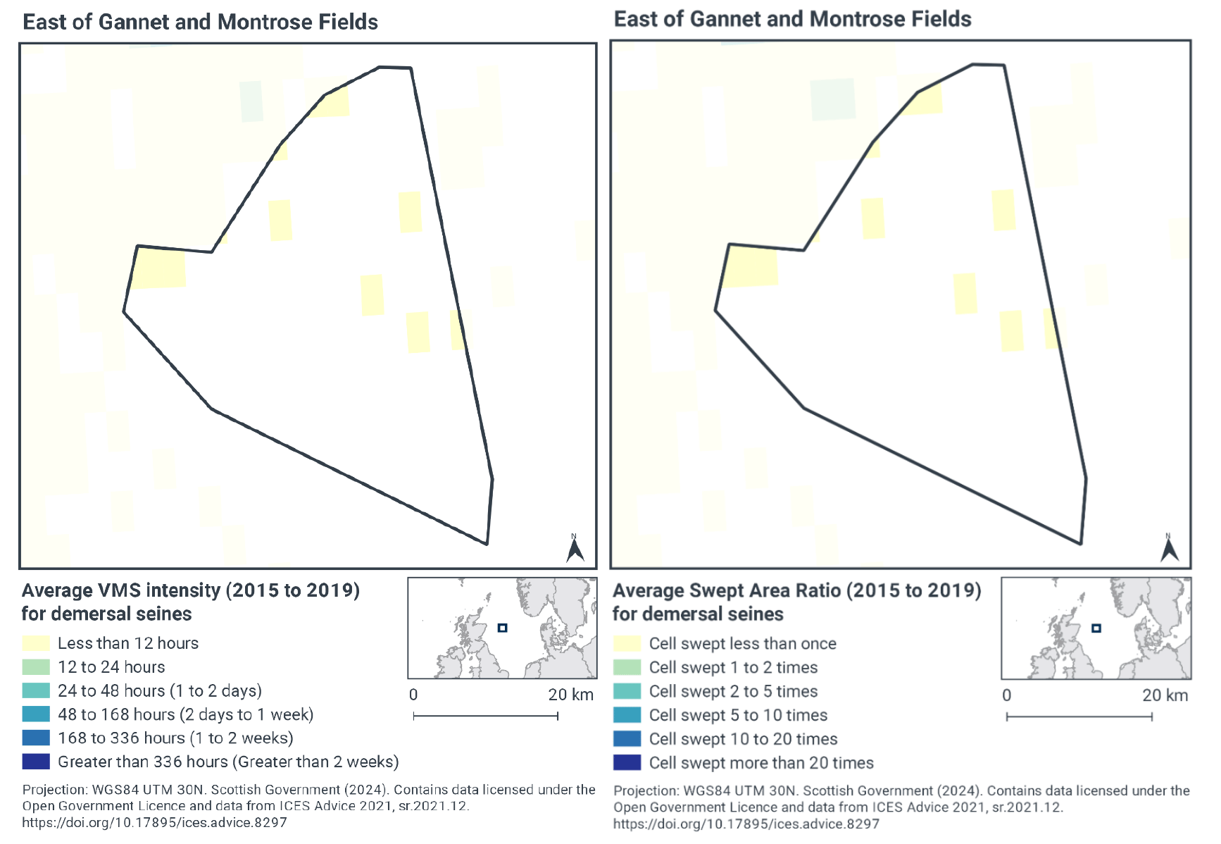
Based on the VMS, demersal seine activity within East of Gannet and Montrose Fields NCMPA is dispersed throughout the northern half site but only occurs at fairly low levels (less than 12 hours per year per grid cell of activity between 2015-2019) (Figure 3).
Swept-Area Ratio (SAR) information averaged over the same time period shows similar patterns of fishing intensity as the VMS data (Figure 3), with areas of low fishing intensity dispersed throughout the northern half of the site, which were swept only once between 2015-2019.
3.2.5 Fishing activity summary
The most common fishing activity within the East of Gannet and Montrose Fields NCMPA is demersal trawling, which is concentrated in the south-east of the site, within the area of offshore deep-sea mud. Demersal seines are more widespread in their distribution over the northern part of the site, however they occur at very low intensities.
3.3 Fishing activity effects overview
The following sections explore the impacts associated with fishing activity within the East of Gannet and Montrose Fields NCMPA (demersal trawls and demersal seines) that were identified as potentially capable of impacting the protected features. The pressures considered in the following sections are:
- Abrasion/disturbance of the substrate on the surface of the seabed;
- Penetration and/or disturbance of the substrate below the surface of the seabed, including abrasion;
- Smothering and siltation rate changes (light); and
- Removal of non-target species.
All four pressures, as exerted by demersal trawls and demersal seines were considered capable of impacting the offshore deep-sea muds, ocean quahog aggregations and the supporting offshore subtidal sands and gravels features within East of Gannet and Montrose Fields NCMPA.
Given the similarity between ‘abrasion/disturbance of the substrate on the surface of the seabed’ and ‘penetration and/or disturbance of the substrate below the surface of the seabed’, these two pressures are considered together in the text below.
Information on overall potential impacts associated with the (demersal trawls and demersal seines) fishing activity is presented below. The detailed pressure information for this section is based on the JNCC Advice and Operation for East of Gannet MPA and JNCC Fisheries Management Options Paper.
3.3.1 Impacts of demersal trawls on offshore deep-sea muds feature
Studies have shown that areas of mud habitats (which includes offshore deep-sea mud) subject to mobile fishing activity may support a modified biological community with lower diversity, reduction or loss of long-lived filter-feeding species and increased abundance of opportunistic scavengers (Ball et al., 2000; Tuck et al., 2000). This effect was greatest in the more heavily fished offshore areas suggesting that impact is related to the intensity of fishing (Ball et al., 2000). Furthermore, modelling studies suggest that the greatest impact is produced by the first pass of a trawl (Hiddink et al., 2006).
Three species of seapens are known to be present within East of Gannet and Montrose Fields NCMPA (JNCC, 2020). The phosphorescent seapen (Pennatula phosphorea) is most abundant, but mainly restricted to the Offshore deep-sea muds, the slender sea pen (Virgularia mirabilis) is found across the entire site, and the tall seapen (Funiculina quadrangularis) mainly found in sandy sediments.
The JNCC and NatureScot Fisheries Management Guidance document for Burrowed mud, inshore deep mud with burrowing heart urchins and offshore deep-sea muds states that Virgularia mirabilis does not appear to be negatively affected by trawling at low levels, possibly as a result of its ability to withdraw into the sediment, however Funiculina quadrangularis has no such ability and its distribution in Scottish waters may have been reduced as a result of nephrops trawling. Furthermore, nephrops may be an important component of the benthic community so fisheries that greatly alter its abundance or size composition may be seen to have a negative impact.
The JNCC and NatureScot Fisheries Management Guidance document for Burrowed mud, inshore deep mud with burrowing heart urchins and offshore deep-sea muds states that if habitats have been impacted by fishing, reduction in effort may be required to allow recovery to favourable condition. However, the degree of reduction that will be required is unknown and further studies or “adaptive” management will be required to establish this. There is risk that cumulative effects of ongoing fishing may result in increasing degrees of modification. Consideration should be given to spatial and/or temporal measures as a mechanism to manage fishing intensity.
The VMS data shows that high levels of demersal trawling takes place in the south east area of East of Gannet and Montrose Fields NCMPA, which is where the offshore deep-sea mud feature occurs. This is indicative of intense trawling activity and therefore the impacts, described above, are likely to occur within this area of the site. However, it is likely that different types of gears pose different levels of risks.
Research on the impact of demersal trawl activity on deep-sea mud is mixed and can depend on the type of trawl used. Pommer et al. (2016) found that benthic community structure in mud habitats was largely determined by depth rather than trawling pressure. Sciberras et al. (2016) found that otter trawling can have an effect on the biogeochemistry of muddy sediments, but the experiment found no significant effect of fishing on total infauna abundance or biomass.
Through physical impacts of gear interacting with the seabed, demersal trawls may impact the physical and biological structure of the offshore deep-sea mud feature via direct physical impacts from gear interacting with the seabed and species. This may impact the extent and distribution regarding topography, sediment composition and biological assemblages. Accordingly, Scottish Ministers concluded that demersal trawls alone, at current activity levels, would or might hinder the conservation objectives for offshore deep-sea muds within East of Gannet and Montrose Fields NCMPA.
3.3.2 Impacts of demersal seines on offshore deep-sea muds feature
Benthic seines are generally of lighter construction than other demersal mobile fishing gear as there are no trawl doors or warps, resulting in less disturbance of the seabed (Polet & Depestele, 2010; Donaldson et al., 2010; Suuronen et al., 2012). As a relative comparison of gear types, otter trawls tend to have less physical impact on the seafloor than beam trawls (and dredges) with the heavy tickler chains of beam trawls able to penetrate up to 8 cm into the seabed, although the doors of an otter trawl can create recognisable scour of the seabed (Hinz et al., 2012; Polet & Depestele, 2010; Lart, 2012; Paschen et al. 2000). The magnitude of the immediate response to fishing disturbance, cumulative effects and recovery times varies significantly according to factors such as the type of fishing gear and fishing intensity, the habitat and sediment type, and levels of natural disturbance and among different taxa (Collie et al., 2000; Boulcott et al., 2014; Kaiser et al., 2006; Hinz et al., 2009; Kaiser et al., 2001). Due to their penetrative nature and close contact with the seabed, scallop dredges cause substantial physical disruption to the seafloor by ploughing sediments and damaging organisms. The Newhaven dredges used by the UK king scallop fishery are likely to be one of the most damaging types of scallop dredge due to the effect of their long teeth, which can penetrate 3 – 10 cm into the seabed (Howarth & Stewart, 2014; Hinz et al., 2012).
Tillin et al. (2010) consider deep-sea muds to have a high sensitivity to the pressure “removal of non-target species” and “siltation rate changes (light)” but acknowledge that there is a lack of direct evidence. The degree to which the East of Gannet and Montrose Fields deep-sea mud habitat is sensitive to the pressure will be dependent on the species present[1].
The VMS data shows that only low levels of demersal seining takes place within East of Gannet and Montrose Fields NCMPA. Given the evidence above, demersal seining alone at current levels of activity would not hinder conservation objectives for offshore deep-sea mud features within East of Gannet and Montrose Fields NCMPA.
3.3.3 Impacts of demersal trawl on ocean quahog feature
Evidence suggests that the ocean quahog (A. islandica) can be caught or damaged by beam trawls (Witbaard and Klein 1994; Klein & Witbaard 1993), with an individual pass of the gear causing around 20% mortality (Bergman and van Santbrink 2000). Population density has been found to be inversely related to beam trawling effort (Craeymeersch et al, 2000). There is some evidence that otter trawl doors may impact ocean quahogs by bringing them to the surface and larger individuals were more affected than smaller bivalves (Rumohr & Krost 1991).
The extent to which mobile gear impacts on sand and gravel sediments can vary considerably, according to the type of gear, the intensity of fishing and the sediment composition. In high energy locations, sediments can become naturally disturbed, whilst in lower energy locations, such as muddy sands and sand in deep water, sediments tend to be more stable.
The JNCC and NatureScot Fisheries Management Guidance document for Arctica islandica states that demersal towed and hydraulic gears that penetrate the sediment (beam trawls, dredges and hydraulic gears including those operated by divers) are likely to reduce the abundance of ocean quahogs. The degree of impact will depend on the intensity of fishing. Further research will help to understand the amount of fishing with these gears (if any) that would be compatible with improving the feature to good condition.
The JNCC and NatureScot Fisheries Management Guidance document for Offshore subtidal sands and gravels states that the variability in the sensitivity of sand and gravel sediments to fishing disturbance is such that site by site consideration of management options is likely to be the best approach. However, there are general points that can be applied. The requirement for management of fishing is more likely in lower energy sites with muddy sands and deep-water sands and gravels. Gears that penetrate deeply into the sediment (>5 cm) would generally be of more concern than those with only surface impacts (e.g. light trawls). In most cases, good information on the distribution and intensity of fishing activity and good knowledge of the current condition of features relative to their potential recovered condition will be required to inform management options.
The VMS data shows that demersal trawling occurs throughout the site and takes place at high levels in the south east area of East of Gannet and Montrose Fields NCMPA. Fewer ocean quahog are present in this area, as they are associated with the offshore subtidal sands and gravels which are located in the north of the site. In that area, there is much lower levels of demersal trawl activity, and therefore the risk of the impacts, described above, are lower. It is also important to note that different types of gears pose different levels of risks.
The last monitoring survey to assess ocean quahog distribution in the site was conducted in 2015 and therefore the extent and condition of this feature and the interaction with demersal trawling in this location is uncertain.
JNCC (2014) management paper highlights there is currently limited evidence and a high degree of uncertainty of the impact of otter trawls on quahog. Scottish Ministers conclude that demersal trawling at current activity levels within the site would not hinder the achievement of conservation objectives for East of Gannet and Montrose Fields NCMPA.
3.3.4 Impacts of demersal seines on ocean quahog feature
Ocean quahog are classed as having medium sensitivity to the pressure, removal of non-target species (including lethal) in FEAST[2]. Hamon et al. (2020) also report ocean quahog as being sensitive to demersal seine fishing due to their capture as bycatch in the southern North Sea, however, this assessment is associated with uncertainty due to the sampling technique not being representative of deep burrowing species and larger epifaunal species. Overall, demersal seines may have a relatively lower impact on ocean quahog and their supporting habitat compared to other demersal towed gears, as the gear is lighter and has no trawl doors or warps.
The VMS data shows that only low levels of demersal seining takes place within East of Gannet and Montrose Fields NCMPA. At current levels of activity it is therefore not thought that this activity would pose a significant risk to the achievement of the conservation objectives.
Given the evidence above, the impacts from demersal seines alone within East of Gannet and Montrose Fields NCMPA at current levels of activity would not hinder the conservation objectives for the Ocean quahog features.
3.4 Part B conclusion
The assessment of impacts of fishing pressures at current activity levels on offshore deep-sea muds and Ocean quahog aggregations features of East of Gannet and Montrose Fields NCMPA has indicated that demersal trawling activities would or might hinder the achievement of the conservation objectives of the site through impacts to offshore deep-sea muds. Demersal seine activities would not hinder the achievement of the conservation objectives of the site at current levels of activity.
Scottish Ministers conclude that management measures are required to restrict demersal trawling within East of Gannet and Montrose Fields NCMPA. Section 5 contains further details on potential measures.
With the introduction of management measures, the Scottish Ministers conclude that the remaining fisheries activities (demersal seines), when considered in isolation, are compatible with the conservation objectives for the site and will not pose a significant risk of hindering the achievement of the conservation objectives of East of Gannet and Montrose Fields NCMPA at current levels of activity.
Contact
Email: marine_biodiversity@gov.scot
There is a problem
Thanks for your feedback