Draft Fisheries Assessment – East of Gannet and Montrose Fields NCMPA: Fisheries management measures within Scottish Offshore Marine Protected Areas (MPAs)
These assessments look at the fishing activity occurring within each offshore MPA and SAC and assess the potential impacts of this activity on the protected features within each site. This assessment is for East of Gannet and Montrose Fields NCMPA.
4. Part C Assessment- In combination assessment
4.1 In combination assessment overview
Part C of this assessments considers the cumulative impacts, which may occur over space and time, in relation to activities occurring within the MPA. Activities assessed in this section include the following:
- Fishing activity/pressure combinations which were excluded in Part A of this assessment as not being capable of impacting;
- Fishing interactions assessed in Part B that would not hinder the conservation objectives for the site; and
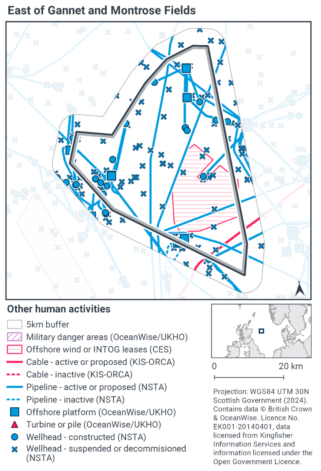
- Activities occurring within East of Gannet and Montrose Fields NCMPA that are not related to fishing.
Fishing activities including demersal trawls have been identified in Part B as requiring management and will therefore not be considered in Part C. Demersal seining was not considered to hinder the achievement of the conservation objectives of the site on their own and so they are assessed in combination with other activities occurring at the site in this Part C.
4.2 Other offshore region activities screening
To determine activities, not related to fishing activities, to be included within this part of the assessment, a distance of 5 km was selected as suitable to capture any potential source receptor pathways that could impact the site in combination with effects of the fishing activities assessed. A 5 km buffer was therefore applied to the site boundary to identify relevant activities.
Activities not related to fishing activities were identified using the Scottish Government’s marine mapping tool. The JNCC Conservation Advice package, and other resources on the JNCC Site Information Centre for East of Gannet and Montrose NCMPA, were also screened for activities occurring in the site that should be considered in the in-combination assessment.
The map to display offshore region activities (see Figure 4) was derived from OceanWise’s Marine Themes Vector data (July 2023 version), Crown Estate Scotland leases (September 2023 version), Kingfisher Information Services Offshore Renewable Cable Awareness (KIS-ORCA, as of December 2023 held under licence) and North Sea Transition Authority (NSTA, as of December 2023, data held under Oil and Gas Authority open licence). The Marine Themes “Industrial” was filtered to show offshore region platforms, wellheads, piles, turbines, cables, and pipelines. Features marked as “not in use”, “not present”, “decommissioned”, or “removed” were excluded. The “Administrative” data were filtered to only show military exercise areas which included danger areas.
4.3 Other offshore region activities occurring within East of Gannet and Montrose Fields NCMPA
The screening exercise using the Scottish Government’s marine mapping tool identified any current cables, pipelines, turbines or piles, wellheads, or offshore region platforms within the site (see Figure 4). There is an offshore region wind lease located within the site marked as an area for Innovation and Targeted Oil and Gas (INTOG). Table 7 provides a list of the relevant activities, including oil and gas infrastructure (including pipelines, platforms and wellheads) and power cables which were considered in combination with the fishing activities occurring within East of Gannet and Montrose Fields NCMPA.
The Activities and Management section of the JNCC Site Information Centre for East of Gannet and Montrose Fields NCMPA, indicates that oil and gas operations occur within the site (Table 7). This includes the presence of pipelines, wellheads, and offshore platforms, as shown in Figure 4. An offshore region wind lease site and/or a site for Innovation and Targeted Oil and Gas (INTOG) was located within the site. This is an area where projects targeting oil and gas decarbonisation will be considered however there are currently no proposed projects, or infrastructure in place for this site and subsequently these were not deemed to be potential for in-combination effects.
| Relevant activity | Description |
|---|---|
| Oil and gas infrastructure (pipelines, platforms and wellheads) | A considerable number of oil and gas development are currently within the NCMPA, and the NCMPA overlaps with a number of license blocks identified by the Department for Business, Energy & Industrial Strategy (formally the Department of Energy and Climate Change) and so may be subject to further oil and gas development in the future. |
| Power cables | Two cables are present within/run through the site. One of these in an active subsea power cable, which runs through the south- east part of the site. The other is a section of infrastructure from a historic submarine power line cable located at the south-west side of the site. |
4.4 Potential pressures exerted by fishing and other plans or projects
To identify the specific pressures that the activities exert on the East of Gannet and Montrose Fields NCMPA features, the Scottish Government has used the JNCC Pressures-Activities Database v1.5. It is only those pressures that are associated with the fishing activities (not assessed in Part B) and the other relevant activities, that have been discussed below. Any pressures that are only associated with the relevant activities, and not the fishing activities, are not within the scope of this assessment.
Table 8 details the pressures exerted by the oil and gas pipelines, exploratory activities and telecommunication cables activities (Y- pressure exerted, N- pressure not exerted) and the associated risk profile, as taken from the JNCC Pressures Activities Database (PAD) v1.5.
| PAD Pressure | Fishing activity | Oil & Gas infrastructure | Power cables | |||||
|---|---|---|---|---|---|---|---|---|
| Demersal seines | Construction | Decommissioning | Operation & maintenance | Pipelines | Decommissioning | Laying, burial and protection | Operation & maintenance | |
| Above water noise | Y - Low risk | Y - Low risk | Y - Low risk | Y - Low risk | Y - Low risk | Y - Low risk | Y - Low risk | Y - Low risk |
| Abrasion/disturbance of the substrate on the surface of the seabed | Y - Medium-high risk | Y - Medium-high | Y - Medium-high | Y - Low risk | Y - Medium-high risk | Y - Medium-high risk | Y - Medium-high risk | Y - Medium-high risk |
| Changes in suspended solids (water clarity) | Y - Medium-high risk | Y - Low risk | Y - Medium-high | Y - Low risk | N | Y - Low risk | Y - Medium-high risk | Y - Medium-high risk |
| Collision above water with static or moving objects not naturally found in the marine environment (e.g., boats, machinery, and structures) | Y - Low risk | Y - Low risk | Y - Low risk | Y - Low risk | Y - Low risk | Y - Low risk | Y - Low risk | Y - Low risk |
| Collision below water with static or moving objects not naturally found in the marine environment (e.g., boats, machinery, and structures) | Y - Low risk | Y - Low risk | Y - Low risk | Y - Low risk | Y - Low risk | Y - Low risk | Y - Low risk | Y - Low risk |
| Deoxygenation | Y - Low risk | N | N | N | Y - Low risk | Y - Low risk | Y - Low risk | Y - Low risk |
| Hydrocarbon & PAH contamination. Includes those priority substances listed in Annex II of Directive 2008/105/EC. | Y - Low risk | Y - Low risk | Y - Medium-high | Y - Low risk | Y - Medium-high | Y - Low risk | Y - Low risk | Y - Low risk |
| Introduction of light | Y - Low risk | Y - Low risk | Y - Low risk | Y - Low risk | Y - Low risk | Y - Low risk | Y - Low risk | Y - Low risk |
| Introduction or spread of invasive non-indigenous species (INIS) | Y - Low risk | Y - Low risk | Y - Low risk | Y - Low risk | Y - Low risk | Y - Low risk | Y - Low risk | Y - Low risk |
| Litter | Y - Low risk | Y - Low risk | Y - Low risk | Y - Low risk | Y - Low risk | Y - Low risk | Y - Low risk | Y - Low risk |
| Nutrient enrichment | Y - Low risk | N | N | N | Y - Low risk | Y - Low risk | Y - Low risk | Y - Low risk |
| Organic enrichment | Y - Low risk | N | N | N | N | N | N | N |
| Penetration and/or disturbance of the substrate below the surface of the seabed, including abrasion | Y - Medium-high risk | Y - Medium-high | Y - Medium-high | Y - Medium-high | Y - Medium-high risk | Y - Medium-high risk | Y - Medium-high risk | Y - Medium-high risk |
| Physical change (to another seabed type) | Y - Low risk | Y - Medium-high | Y - Medium-high | Y - Low risk | Y - Low risk | Y - Medium-high risk | Y - Medium-high risk | Y - Medium-high risk |
| Physical change (to another sediment type) | Y - Low risk | Y - Medium-high | Y - Medium-high | Y - Low risk | Y - Low risk | Y - Medium-high risk | Y - Medium-high risk | Y - Medium-high risk |
| Removal of non-target species | Y - Medium-high risk | N | N | Y - Low risk | N | N | N | N |
| Removal of target species | Y - Medium-high risk | N | N | Y - Low risk | N | N | N | N |
| Smothering and siltation rate changes (Light) | Y - Medium-high risk | Y - Low risk | Y - Medium-high | Y - Low risk | Y - Medium-high | Y - Low risk | Y - Medium-high risk | Y - Medium-high risk |
| Synthetic compound contamination (incl. pesticides, antifoulants, pharmaceuticals). Includes those priority substances listed in Annex II of Directive 2008/105/EC. | Y - Low risk | Y - Medium-high | Y - Medium-high | N | Y - Low risk | Y - Low risk | Y - Low risk | Y - Low risk |
| Transition elements & organo-metal (e.g. TBT) contamination. Includes those priority substances listed in Annex II of Directive 2008/105/EC. | Y - Low risk | Y - Low risk | Y - Medium-high | Y - Low risk | Y - Low risk | Y - Low risk | Y - Low risk | Y - Low risk |
| Underwater noise changes | Y - Low risk | Y - Medium-high | Y - Medium-high | Y - Low risk | Y - Low risk | Y - Low risk | Y - Low risk | Y - Low risk |
| Visual disturbance | Y - Low risk | Y - Low risk | Y - Low risk | Y - Low risk | Y - Low risk | Y - Low risk | Y - Low risk | Y - Low risk |
4.5 Significance of effects/impacts to protected features
Both abrasion and penetration pressures are at medium-high risk of occurring during demersal seine activity, power cables decommissioning, laying, burial and protection, operation and maintenance, and during oil and gas construction, and decommissioning, and during pipeline activities. Operation and maintenance of oil and gas activities has a low risk profile for Abrasion pressure, however this has a medium-high risk profile for the Penetration pressure.
Demersal seine activity within East of Gannet and Montrose Fields NCMPA, as described within Section 3.2.4., was found to occurring only at very low levels and largely in the northern half of the site during 2015-2019.
Power cables therefore, with a relatively small footprint and not overlapping with the existing areas of demersal seine activity are unlikely to result in in-combination impacts. Furthermore, one of the power cables is historic (already decommissioned), and as the other is already in situ, only the operation and/or maintenance activity associated with the single active power cable will be relevant with the potential to exert the abrasion and penetration pressures with a medium-high risk profile.
The oil and gas activity within East of Gannet and Montrose Fields NCMPA is located throughout the site, with three main platforms and associated wellheads being located in the north, north-west and south-east of the site. As the infrastructure is already in situ, the construction activity is not relevant. Therefore, only oil and gas operation and maintenance, decommissioning and pipelines pose a risk of in-combination impacts. As mentioned above, oil and gas decommissioning and pipelines pose a medium-high risk profile of exerting both these pressures, whilst operation and maintenance poses a medium-high risk of Penetration pressure only.
As offshore oil and gas activities are a licensable activity, these are subject to the Conservation of Offshore Marine Habitats and Species Regulations 2017 and other legislation[3], and are therefore obliged to complete the relevant assessments on potential impacts of activities to Marine Protected Areas. This is regulated by the Oil and Gas Authority (OGA) for exploration and development and the Offshore Petroleum Regulator for Environment and Decommissioning (OPRED). Therefore, it is unlikely that oil and gas production, exploration and installation and decommissioning will have a significant in-combination impact with fishing and other activities via this pressure.
4.6 Part C Conclusion
Scottish Ministers conclude that the remaining fishing activities (demersal seines) at current activity levels in-combination with other relevant activities will not hinder the achievement of the conservation objectives for East of Gannet and Montrose Fields NCMPA.
Contact
Email: marine_biodiversity@gov.scot
There is a problem
Thanks for your feedback