Draft Fisheries Assessment – East Rockall Bank SAC: Fisheries management measures within Scottish Offshore Marine Protected Areas (MPAs)
These assessments look at the fishing activity occurring within each offshore MPA and SAC and assess the potential impacts of this activity on the protected features within each site. This assessment is for East Rockall Bank SAC.
3. Part B Assessment – Fisheries Assessment
3.1 Fishing assessment overview
Part B of this assessment meets the requirements for an appropriate assessment under Article 6(3) of Council Directive 92/43/EEC of 21 May 1992 on the conservation of natural habitats and of wild fauna and flora (the Habitats Directive) and Regulation 28 of the Conservation of Offshore Marine Habitats and Species Regulations 2017.
The fishing activities and pressures identified in Part A, at the levels identified in the relevant date range, which have been included for assessment in Part B, are demersal trawls, demersal seines, and anchored nets/lines. The only pressures associated with these fishing activities that have been included in Part B are:
- abrasion/disturbance of the substrate on the surface of the seabed;
- penetration and/or disturbance of the substrate below the surface of the seabed, including abrasion;
- smothering and siltation rate changes (light);
- removal of non-target species and
- removal of target species.
3.2 Fishing Activity Descriptions
3.2..1 Existing management of fishing activity within East Rockall Bank SAC
In compliance with Part 5, Chapter 7 of The Common Fisheries Policy and Aquaculture (Amendment etc.) (EU Exit) Statutory Instrument (S.I.) 2019 No. 753, there is a ban on the use of all bottom-contacting mobile gear below 800 metres depth across all UK waters. This applies across the area of East Rockall Bank SAC where the depth falls below 800 metres. Part 5 Chapter 7 of S.I. 2019, No. 753 also implements restrictions on fishing between 400 metres and 800 metres where Vulnerable Marine Ecosystems (VMEs) are present, or are likely to occur. These rules aim to minimise the impact of fishing activities on VMEs. Under The Common Fisheries Policy and Animals (Amendment etc.) (EU Exit) Regulations 2019 S.I. 2019, No. 1312 (amending S.I. 2019, No. 753) there is a prohibition on the use of bottom-set gillnets, entangling nets, and trammel nets at depths greater than 200 metres for the protection of deepwater shark species. These protective measures are also applied in the North-East Atlantic Fisheries Commission (NEAFC) technical measures regulatory area (beyond European Union waters) through the same Statutory Instrument. The restrictions on the use of gillnets extends throughout the site, although in the inside edge these restrictions are only seasonal.
3.2..2 Fishing activity within East Rockall Bank SAC
The East Rockall Bank SAC overlaps ICES rectangles 42D6, 43D6, 43D7, 44D6, 44D7, 45D5, 45D6, 45D7 and 46D5 in the Rockall (ICES Division 6b), in the Rockall and Bailey regions. The main gear types for UK vessels are demersal trawls and set nets, predominantly catching haddock and monk/anglerfish.
VMS-based estimates and ICES rectangle landings statistics indicate that over-12 m set nets and demersal trawls are the predominant UK vessels that operated within the site over the period 2015-2019.
For the over-12 m vessels, based on VMS data from 2015-2019, set nets and demersal trawls operate predominantly along the western site boundary arc.
In addition to UK activity, vessels from Ireland (27 vessels), Norway (8 vessels), Faroes (6 vessels), Germany (5 vessels), France and Spain (number of vessels cannot be disclosed) may also operate in the site, based on VMS data from 2015-2019. However, it is not clear what gear types these vessels operate, nor whether they were actively fishing at the time.
3.2..3 Demersal trawls
The aggregated gear method of demersal trawls includes multiple gears that operated within the East Rockall Bank SAC between 2015 and 2019. These include bottom otter trawls and multi-rig trawls (Table 2). The target species for these gear types are demersal fish, industrial, Nephrops and molluscs. Similar pressures are exerted by the different gears used for demersal trawling, subsequently the aggregated gear type of ‘demersal trawl’ was used to map activity across the site.
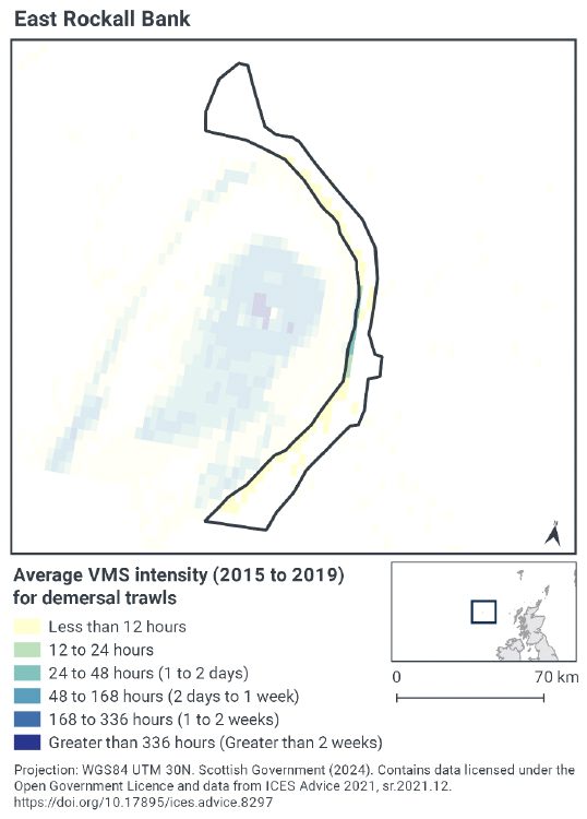
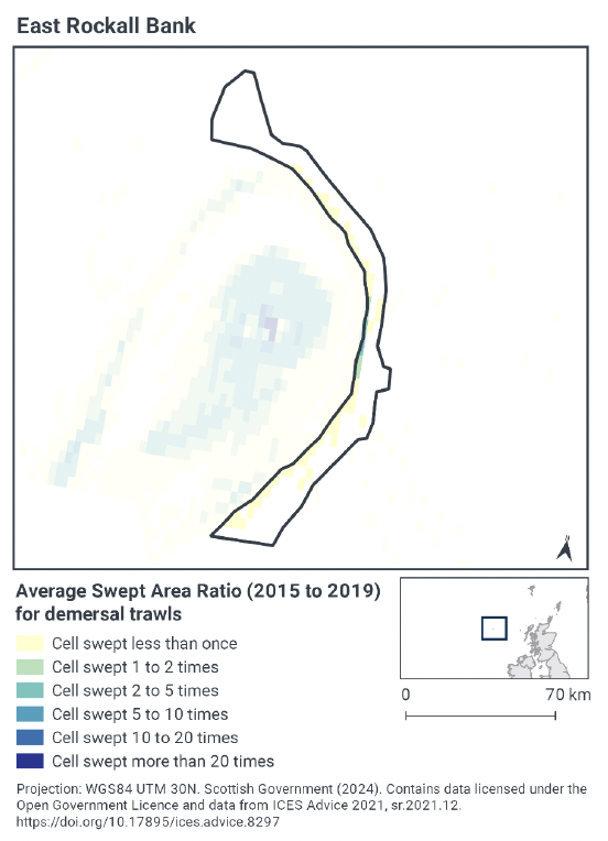
According to VMS intensity averaged over 2015 to 2019, the distribution of demersal trawling broadly occurs along the western boundary of the site (Figure 2), however it occurs at fairly low levels (less than 12 hours per year per grid cell). Only one small area along this boundary has slightly higher levels of activity, peaking at 24-48 hours per year per grid cell. The remainder of the site either has no activity, or less than 12 hours of activity per year per grid cell, such as in the central area of the west side of the site.
Swept-Area Ratio (SAR) information averaged over the same time period shows similar pattern of fishing intensity as the VMS data (Figure 2). The highest SAR values are along the western boundary of the site, however this is only at very low levels with cells swept less than once. Only one small area along this boundary has slightly higher activity, where cells were swept 2 – 5 or 1 – 2 times per year per grid cell. The remainder of the site either has no activity, or cells being swept less than once.
The locations where this demersal trawling activity occurs overlaps slightly with an area of high confidence and potential Annex I Reef, and it occurs very close to one area of known cold-water coral reef.
3.2..4 Demersal seines
Only one demersal seine gear type operated within the East Rockall Bank SAC between 2015 and 2019 (Table 2), which was anchor seines. The target species for this gear type is demersal fish.
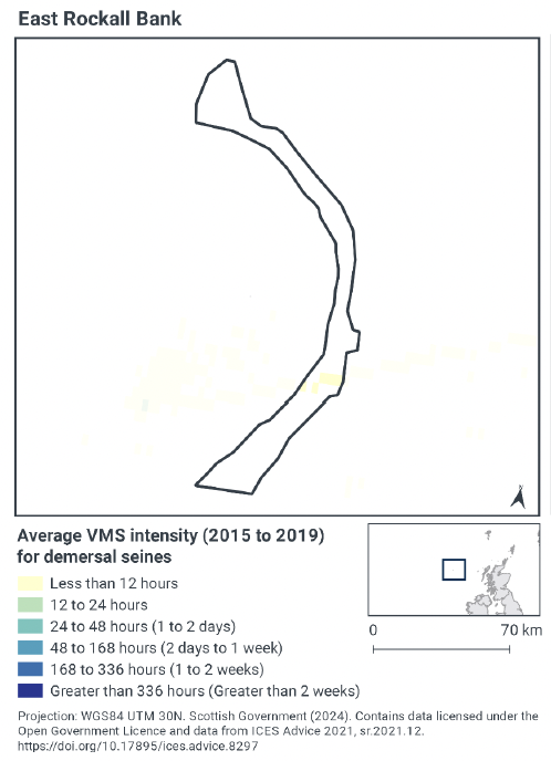
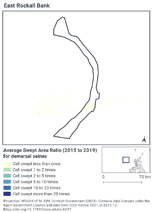
According to VMS intensity averaged over 2015 to 2019, demersal seines activity only occurred in a very small area in the south of the site, where less than 12 hours of activity occurred per year per gird cell (Figure 3). No activity occurred in the remainder of the site.
Swept-Area Ratio (SAR) information averaged over the same time period shows similar patterns of fishing intensity as the VMS data (Figure 3). The only activity was in the south of the site, with only a small number of cells swept less than once per year per grid cell. No activity occurred in the remainder of the site.
The locations where this demersal seine activity occurs overlaps with an area of high confidence and potential Annex I Reef, however it does not overlap any of the known cold-water coral reef areas.
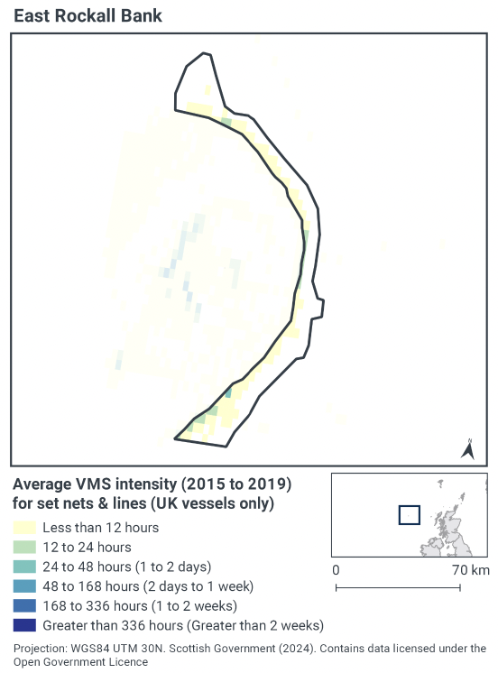
3.2..5 Anchored nets/lines
Only one anchored nets/lines gear type operated within the East Rockall Bank SAC between 2015 and 2019 (Figure 4), which was set gillnets. The target species for this gear type is demersal fish.
According to VMS intensity averaged over 2015 to 2019, anchored nets/line activity occurs along the western side of the site, however this is mainly at fairly low levels of less than 12 hours of activity per year per grid cell (Figure 4). In a few areas along the western boundary, this activity is slightly higher, either 12-24 hours per year per grid cell, or 24 to 48 hours per year per grid cell.
The locations where this anchored nets/line activity occurs overlaps with the area of high confidence and potential Annex I Reef, and it occurs close to one area of known cold-water coral reef.
3.2..6 Summary of fishing activity within East Rockall Bank SAC
The most common fishing activity within the East Rockall Bank SAC is demersal trawling, however this is mainly concentrated along the western boundary of the site, mostly occurring at low levels. Demersal seine activities are more restricted in their distribution and only occur at very low levels in a small area in the south of the site. Anchored nets/lines activity is distributed on the western side of the site, mostly at fairly low levels, although some small areas of greater activity are present.
The fishing activity for all gear types appears to overlap with areas of high confidence or potential Annex I Reef. There are also a couple of locations where either demersal trawling or anchored nets/line activity are close to areas of known cold-water coral reef. The demersal seine activity does not overlap any of these known areas, however.
3.3 Fishing activity effects overview
The following sections explore the pressures associated with fishing activity (demersal trawls, demersal seines and anchored nets/lines) within the East Rockall Bank SAC that were identified as potentially having likely significant effects (LSE) on the reef feature. The pressures considered in the following sections are:
- Abrasion/disturbance of the substrate on the seabed;
- Penetration and/or disturbance of the substrate below the surface of the seabed, including abrasion;
- Smothering and siltation rate changes (light);
- Removal of target species; and
- Removal of non-target species.
All five pressures, as exerted by mobile demersal fishing (trawls and seines), were considered to have the potential for LSE. For static demersal fishing (anchored nets/lines), only abrasion/disturbance of the substrate on the surface of the seabed, removal of target species, and removal of non-target species were considered to have the potential for LSE.
Given the similarity between ‘abrasion/disturbance of the substrate on the surface of the seabed’ and ‘penetration and/or disturbance of the substrate below the surface of the seabed’, these two pressures are considered together in the text below. All pressures with the potential for LSE are discussed under the aggregated fishing gear types of ‘mobile demersal gears’ and ‘static demersal gear’.
The detailed pressure information for this section is based on the JNCC Advice on Operations for East Rockall Bank SAC, and the JNCC Fisheries Management Options Paper for East Rockall Bank SAC.
3.3..1 Impacts of demersal mobile gear (trawls and seines) on Annex I Reef
As detailed in the JNCC Advice on Operations for East Rockall Bank SAC, abrasion/disturbance of the substrate on the surface of the seabed and penetration and/or disturbance of the substrate below the surface of the seabed, including abrasion, occur where gear makes contact with the seafloor. The area affected is determined by the footprint of the gear and the amount of movement across the seabed. The different gear components will make variable contributions to the total physical disturbance of the seabed and its associated biota, and hence the pressure will vary according to factors such as gear type, design/modifications, size and weight, method of operation (including towing speed) and habitat characteristics (e.g. topography) (Lart, 2012; Polet & Depestele, 2010; Suuronen et al., 2012). Towed bottom fishing gears are used to catch species that live in, on or in association with the seabed and therefore are designed to remain in close contact with the seabed. That interaction with the seabed can lead to disturbance of the upper layers of the seabed, direct removal, damage, displacement or death of the benthic flora and fauna; short-term attraction of scavengers; and the alteration of habitat structure (Kaiser et al., 2003; Gubbay & Knapman, 1999; Sewell & Hiscock, 2005; Collie et al., 2000; Kaiser et al., 2002).
Benthic seines are generally of lighter construction as there are no trawl doors or warps, resulting in less disturbance of the seabed than trawling (Polet & Depestele, 2010; Donaldson et al., 2010; Suuronen et al., 2012). As a relative comparison of gear types, otter trawls tend to have less physical impact on the seafloor than beam trawls (and dredges) with the heavy tickler chains of beam trawls able to penetrate up to 8 cm into the seabed, although the doors of an otter trawl do create recognisable scour of the seabed (Hinz et al., 2012; Polet & Depestele, 2010; Lart, 2012; Paschen et al. 2000). The magnitude of the immediate response to fishing disturbance, cumulative effects and recovery times varies significantly according to factors such as the type of fishing gear and fishing intensity, the habitat and sediment type, and levels of natural disturbance and among different taxa (Collie et al., 2000; Boulcott et al., 2014; Kaiser et al., 2006; Hinz et al., 2009; Kaiser et al., 2001).
Smothering and siltation rate changes (light) may result from physical disturbance of the sediment, along with hydrodynamic action caused by the passage of towed gear, leading to entrainment and suspension of the substrate behind and around the gear components and subsequent siltation (Gubbay & Knapman, 1999; Lart, 2012; Sewell et al., 2007; Kaiser et al., 2002; Riemann & Hoffmann, 1991; O'Neill et al., 2008; Dale et al., 2011; O'Neil & Summerbell, 2011). The quantity of suspended material, its spatial and temporal persistence and subsequent patterns of deposition will depend on factors associated with the gear (such as type/design, weight, towing speed), sediment (particle size, composition, compactness), the intensity of the activity and the background hydrographic conditions (Sewell et al., 2007; Kaiser et al., 2002; Dale et al., 2011; O'Neil & Summerbell, 2011). Sediment remobilisation and deposition can affect the settlement, feeding, and survival of biota through smothering of feeding and respiratory organs. Prolonged exposure of an area to the pressure may result in changes in sediment composition (Gubbay & Knapman, 1999; Kaiser et al., 2002; O'Neil & Summerbell, 2011; Kaiser et al., 2003; Sewell et al., 2007).
The Annex I reef feature is not a target of any fishing activity occurring within the SAC. Demersal trawls target a range of demersal fish species and may also remove non-target species which may themselves be of conservation importance or may form part of the biotope (e.g. Norway lobster - Nephrops norvegicus) or wider community composition associated with protected features/sub-features. As part of targeted fisheries, incidental non target catch may also be retained and landed due to its commercial value (e.g. spiny lobster (Palinurus elephas), lobsters (Homarus gammarus), crabs, scallops (Pecten spp.), etc). These species may be considered part of the wider community composition associated with features or sub-features of protected sites or may themselves be of conservation importance (e.g. crawfish) (Sewell & Hiscock 2005; JNCC & NE 2011).
Bycatch (i.e. discarded catch) is associated with almost all fishing activities and is related to factors such as gear type and its design (i.e. its selectivity), the target species and effort. There are significant concerns over the impacts of discards on marine ecosystems including changes in population abundance and demographics of affected species and altered species assemblages and food web structures (Alverson et al., 1994; Kaiser et al., 2001). As with other benthic towed gears, discarding of fish species from demersal seine net fisheries can be significant (Polet & Depestele, 2010; ICES, 2011). There are relatively few studies of the non-fish bycatch composition for demersal seines, however, it is probably similar to that of demersal trawls e.g. crustaceans and other invertebrates, etc., although quantities of such bycatch are likely to be lower than that of other gear types such as beam trawls (Suuronen et al., 2012; ICES, 2011; Donaldson et al., 2010; Walsh & Winger, 2011). Mixed-species and shrimp/prawn demersal trawl fisheries are associated with the highest rates of discarding and pose the most complex problems to resolve (Alverson et al., 1994; Feekings et al., 2012; Catchpole et al., 2005). Benthic trawls most frequently result in bycatch of fish crustaceans and other invertebrates and less frequently turtles and birds (Gubbay & Knapman, 1999; Sewell & Hiscock, 2005; ICES, 2013; Pierpoint, 2000; Bergmann & Moore, 2001; Catchpole et al., 2005; Tulp et al., 2005).
Whilst it is unlikely that mobile bottom contact gear (demersal trawls and demersal seines) can affect the long-term natural distribution of bedrock and stony reef features, there is evidence to indicate that the use of bottom contacting mobile gears can impact the structure and function of the habitat and the long term survival of its associated species.
The use of towed fishing gears is likely to cause damage or death of fragile, erect species, such as sponges and corals (Løkkeborg, 2005; Freese et al. 1999). Other species such as hydroids, anemones, bryozoans, tunicates, and echinoderms may also be vulnerable (McConnaughey et al. 2000, Sewell and Hiscock 2005). Where fragile, slow growing species occur, even low levels of fishing have the potential to change the structure and function of the habitats and may result in the loss of some characteristic species. Recovery from such damage is estimated to be measured in decades, depending on the environmental conditions (Clark et al. 2010; ICES, 2010).
Mobile bottom contact gears reduce the long-term natural distribution of cold water coral (biogenic reef) features, as well as impacting the structure and function of the habitat and the long term survival of its associated species.
The passage of trawls may increase mortality of the coral by crushing, burying, or wounding corals, increasing susceptibility to infection and epifaunal recruitment that may eventually smother corals (Fosså et al. 2002). The passing of a heavy trawl reduces the three-dimensional structure of the coral to rubble, decreasing the complexity of the habitat with impacts on the associated community composition (Koslow et al. 2001, Fosså et al. 2002). Indirect impacts on cold water coral reefs from trawling are from increased levels of suspended particles in the water column causing smothering and polyp mortality (Larsson and Purser, 2011). Corals are slow growing so any damage will take many years to repair (ICES, 2010).
VMS data shows that demersal trawling is mainly concentrated along the western boundary of the site, yet mostly occurs at low levels. Demersal seine activities are more restricted in their distribution and only occur at very low levels in a small area in the south of the site. This appears to overlap with areas of high confidence or potential Annex I Reef, and the demersal trawl activity is close to one area of known cold-water coral reef. The demersal seine activity however does not overlap any of these known areas.
With regards to the discussion above and the assessed activity levels, the Scottish Ministers conclude that impacts from demersal mobile gear (demersal trawling and demersal seines) on the Annex I Reef feature, particularly the cold-water coral reef (biogenic reef), within East Rockall Bank SAC are not compatible with the conservation objectives of the site and could result in an adverse effect on site integrity at current levels of activity.
3.3..2 Impacts of static demersal gear (anchored nets/lines) on Annex I Reef
As detailed in the JNCC Advice on Operations for East Rockall Bank SAC, abrasion/disturbance of the substrate on the nets/lines themselves and any footropes and anchors. This is most likely to happen during retrieval of the gear if it is dragged along the seabed before ascent, although disturbance of the seabed can occur while the gear is fishing if movement (particularly of any anchors) occurs during rough weather, for example, or otherwise. Such physical disturbance can result in epifauna, especially emergent species such as erect sponges and coral, being dislodges (including snagged in the net) or damaged, although there are limited studies of such effects (Lart, 2012; Polet & Depestele, 2010; Sewell & Hiscock, 2005; Suuronen et al., 2000; Auster & Langton, 1999).
For removal of target species, anchored nets and lines are used to target pelagic, demersal and benthic fish and crustacean species. The Annex I reef feature is not a target of any fishing activity occurring within the SAC. Anchored nets and lines can result in the targeted removal of features of conservation importance (e.g. spiny lobster (Palinurus elephas), salmon (Salmo salar)) and also species which form part of the community composition of features or sub-features e.g. species such as crab and lobster (Homarus gammarus) which may be associated with reef features and other species such as whelks (Gubbay & Knapman, 1999; Sewell & Hiscock, 2005; JNCC & NE, 2011).
Bycatch (i.e. discarded catch) is associated with almost all fishing activities and is related to factors such as the gear type and its design (i.e. its selectivity), the targeted species and effort. Anchored nets, including gill and trammel nets, can result in the entanglement and bycatch of a range of fauna including mammals, turtles, fish, elasmobranchs, crustaceans and other invertebrates and birds (Gubbay & Knapman, 1999; ICES, 2013; WWT, 2012; Žydelis et al., 2009; Pierpoint, 2000; Oliver et al., 2015) the consequences of which can be significant to species and populations (Reeves et al., 2013; Furness, 2003; Tasker et al., 2000). Further, ghost fishing has been associated with lost gear (Matsuoka et al., 2005). Although highly selective for the larger pelagic fish, longlines can cause by-catch of large and frequently long-lived species including invertebrates (Hall et al., 2000; Gubbay & Knapman, 1999; Sewell & Hiscock, 2005; Dayton et al., 1995). In the UK, long line fishing is operated on a small scale by only a few inshore vessels in different parts of the country.
Static bottom contact gears are unlikely to affect the long-term natural distribution of bedrock and stony reef features, but there is evidence to indicate that their use can impact the structure and function of the habitat and the long term survival of its associated species.
Mechanical impacts of static gear (e.g., weights and anchors hitting the seabed, hauling gear over seabed, rubbing/entangling effects of ropes) can damage some species (Eno et al. 1996). Other species appear to be resilient to individual fishing operations, but the effects of high fishing intensity are unknown (Eno et al. 2001). Recovery will be slow (Foden et al. 2010) resulting in significant reduction or even loss of characteristic species. The individual impact of a single fishing operation may be slight but cumulative damage may be significant (Eno et al. 2001; Foden et al. 2010).
Static bottom contact gears are likely to reduce the long-term natural distribution of cold water coral (biogenic reef) features, as well as impacting the structure and function of the habitat and the long term survival of its associated species.
The impacts are considered to be lower than for demersal mobile gear types (Pham et al. 2014), however impacts to habitats and biota may occur during certain conditions. For example, hooks, lines, nets, and ropes entangle corals and ‘pluck’ them during hauling (Grehan et al., 2004; ICES, 2010; Sampaio et al. 2012). Physical damage to the seabed has been observed which may be caused by dragged anchors (Grehan et al. 2004; ICES, 2010). The individual impact of a single fishing operation may be slight but cumulative damage can be significant. Given the slow growth rate of cold water corals, structurally and biologically diverse coral communities may take centuries to recover from damage, if at all (Fosså et al. 2000 & 2002; ICES advice, 2005-2010).
VMS data shows that anchored nets/lines activity is distributed on the western side of the site, mostly at fairly low levels, although some small areas of greater activity are present. This appears to overlap with areas of high confidence or potential Annex I Reef, and is close to one area of known cold-water coral reef.
With regards to the discussion above and the assessed activity levels, the Scottish Ministers conclude that impacts from anchored nets/lines on the Annex I Reef feature, particularly the cold-water coral reef (biogenic reef), within East Rockall Bank SAC are not compatible with the conservation objectives of the site and could result in an adverse effect on site integrity at current levels of activity.
3.4 Part B Conclusions
The assessment of fishing pressures at current activity levels on reef features of the East Rockall bank SAC has indicated that an adverse effect on site integrity cannot be ruled out where mobile demersal fishing (demersal trawl and demersal seine) and anchored nets/line activities occur. As such Scottish Ministers conclude that management measures are required to restrict these activities within East Rockall Bank SAC. Section 5 contains further details on potential measures.
Contact
Email: marine_biodiversity@gov.scot
There is a problem
Thanks for your feedback