Draft Fisheries Assessment – East Rockall Bank SAC: Fisheries management measures within Scottish Offshore Marine Protected Areas (MPAs)
These assessments look at the fishing activity occurring within each offshore MPA and SAC and assess the potential impacts of this activity on the protected features within each site. This assessment is for East Rockall Bank SAC.
4. Part C Assessment- In Combination Assessment
4.1 In combination assessment overview
This section assess the in-combination provision within under Article 6(3) of Council Directive 92/43/EEC of 21 May 1992 on the conservation of natural habitats and of wild fauna and flora (the Habitats Directive) to take account of the cumulative impacts, which may occur over space and time, in relation to plans or projects which are completed, approved but uncompleted, or proposed. Activities assessed in this section include the following:
- Fishing activity/pressure combinations which were excluded in Part A of this assessment as having no likely significant impact;
- Fishing interactions assessed in Part B but not resulting in adverse effects; and
- Plans and projects occurring within East Rockall Bank SAC that are not related to fishing.
Fishing activities including demersal trawls, demersal seines and anchored nets/lines have been identified in Part B as requiring management to avoid adverse effects to site integrity and will therefore not be considered in Part C. No other fishing activities occur within the site that require assessment in combination with other plans or projects within Part C.
4.2 Other offshore region activities screening
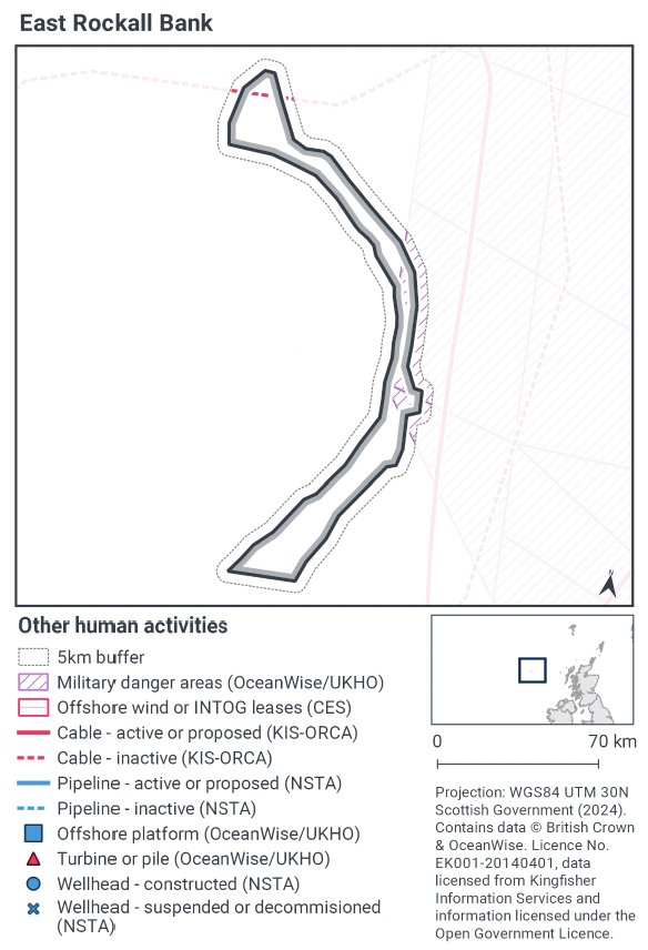
To determine plans and projects, not related to fishing activities, to be included within this part of the assessment, a distance of 5 km was selected as suitable to capture any potential source receptor pathways that could impact the site in combination with effects of the fishing activities assessed. A 5 km buffer was therefore applied to the site boundary to identify relevant plans and projects.
Plans and projects not related to fishing activities were identified using the Scottish Government’s marine mapping tool. The NatureScot and JNCC Conservation Objectives and Advice on Operations, and other resources on the JNCC Site Information Centre for Braemar Pockmarks SAC were also screened for activities occurring in the site that should be considered in the in-combination assessment.
The map to display offshore region activities (see Figure 5) was derived from OceanWise’s Marine Themes Vector data (July 2023 version), Crown Estate Scotland leases (September 2023 version), Kingfisher Information Services Offshore Renewable Cable Awareness (KIS-ORCA, as of December 2023 held under licence) and North Sea Transition Authority (NSTA, as of December 2023, data held under Oil and Gas Authority open licence). The Marine Themes “Industrial” was filtered to show offshore region platforms, wellheads, piles, turbines, cables, and pipelines. Features marked as “not in use”, “not present”, “decommissioned”, or “removed” were excluded. The “Administrative” data were filtered to only show military exercise areas which included danger areas.
4.3 Other offshore region activities occurring within East Rockall Bank SAC
The screening exercise using the Scottish Government’s marine mapping tool showed a military danger area overlapping with the eastern side of the site and one inactive cable that crosses through the site (Figure 5). The military danger area is a surface danger area / firing danger area and was not considered able to impact the seafloor reef feature.
According to the Activities and Management section of the JNCC Site Information Centre for East Rockall Bank SAC, the cable is a telecommunications cable, and no other activities were known to be present.
Table 6 provides a list of these activities, however considering the absence of activities that had the potential for likely significant effects, the assessment did not identify any in-combination activities that could adversely affect the site integrity of East Rockall Bank SAC.
Table 6. Plans and projects in East Rockall Bank SAC.
Relevant activity: Military activity - Overlap with a military danger area (surface / firing)
Relevant activity: Telecommunications cable - One telecommunications cable crosses through the MPA, however this is currently in active.
4.4 Potential pressures exerted by fishing and other plans or projects
Fishing activities including demersal trawls, demersal seines and anchored nets/lines have been identified in Part B as requiring management to avoid adverse effects to site integrity were considered in Part B. No other fishing activities occur within the site that require assessment in combination with other plans or projects within Part C.
4.5 Significance of effects/impacts to protected features
None of the other offshore region activities occurring within East Rockall Bank SAC exerted pressures on the Annex I Reef features that would overlap with the pressures exerted by fishing activities highlighted in section B. As the military activity is surface level and the inactive cable is exerting any additional pressures. Subsequently, there were no likely significant effects identified within the in-combination assessment. Considering the absence of likely significant effects, the assessment did not identify any in-combination activities that could adversely affect the integrity of East Rockall Bank SAC.
4.6 Part C conclusion
Scottish Ministers did not determine any other fishing activities to be considered within Part C and conclude that other relevant activities will not adversely affect the site integrity of East Rockall Bank SAC, at currently levels of activity.
Contact
Email: marine_biodiversity@gov.scot
There is a problem
Thanks for your feedback