Draft Fisheries Assessment – Firth of Forth Banks Complex NCMPA: Fisheries management measures within Scottish Offshore Marine Protected Areas (MPAs)
These assessments look at the fishing activity occurring within each offshore MPA and SAC and assess the potential impacts of this activity on the protected features within each site. This assessment is for Firth of Forth Banks Complex NCMPA.
1. Introduction
1.1 Scope of the Firth of Forth Banks Complex NCMPA assessment
The geographic scope of this assessment covers the whole of Firth of Forth Banks Complex NCMPA. The purpose of this assessment is to determine whether the current levels of fishing activities would or might hinder the conservation objectives of the Firth of Forth Banks Complex NCMPA and to identify options for management measures.
In this assessment, Scottish Ministers use the best available evidence to review the site characteristics and current fishing activity (Part A), both taken alone and in combination with other relevant activities (Part C), to determine if the fishing activities are capable of impacting the protected features (ocean quahog aggregations and offshore subtidal sands and gravels). Any fishing activities capable of impacting the protected features, either alone or in combination with other relevant activities, are considered further to assess whether they would or might hinder the achievement of the conservation objectives (Part B).
Where there is the potential for the achievement of the conservation objectives to be hindered, or in the case of this site, potentially require a higher level of protection due to other factors (see section 5), management measures are identified for the site by the Scottish Ministers. These measures are considered in light of the conservation objectives, biological characteristics, current fishing and other activity levels and existing fisheries restrictions for Firth of Forth Banks Complex NCMPA. A final decision on which measures, if any, are to be adopted, will follow upon a statutory consultation exercise and will take into account all relevant statutory obligations incumbent upon Scottish Ministers.
Draft Fisheries Assessments have assessed only protected features of SACs and NCMPAs which are categorised as habitats and mobile species. Geomorphological and large-scale features have not been scoped into these assessments. JNCC’s advice supports the rationale that these protected features do not require assessment as fishing activities are unlikely to impact the conservation objectives of these features. However, this does not preclude the need for potential management in the future.
A methodology document has been prepared to aid understanding of these assessments.
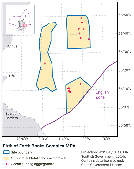
1.2 Site description
The Firth of Forth Banks Complex NCMPA (Figure 1) is located in offshore waters to the east of Scotland, and includes the Berwick, Scalp and Montrose Banks and the Wee Bankie. The NCMPA covers an area of 2,130 km2 and is composed of a series of underwater banks and mounds which are overlaid with a mix of sands and gravels.
Strongly influenced by water currents, the conditions create a mosaic of different habitat types. This mosaic is driven by the interaction between the bank features and oceanic currents, resulting in varying sedimentary deposition rates and a patchwork of different sediment types. The predominant seabed habitats are sands and coarse sediments within the circalittoral and deep circalittoral biological zones across the MPA.
The Wee Bankie includes an area of unusual seabed, formed from underwater glacial ridges deposited during the last Ice Age. This feature is scientifically important for its role in improving our understanding of the history of glaciation around Scotland.
The eastern area has seabed habitats comprising of offshore deep circalittoral sands with small banks of offshore deep circalittoral coarse sediment. As the seabed shallows toward the Wee Bankie area, the raised banks are coarse sedimentary becoming more reflective of shallower inshore sedimentary habitats. This pattern remains the case over the raised areas of this region, with the troughs and deeper channels holding circalittoral muddy sands and deep circalittoral sands (Sotheran & Crawford-Avis, 2014a & b).
The mosaic of sands and gravels support a variety of species, including the ocean quahog (Arctica islandica) which can be found living buried in the sandier sediments. Ocean quahogs are typically found below the surface of medium-to fine-grained sand, sandy mud and silty-sand (Sabatini & Pizzolla, 2008) and in water depths of 4 to over 400 m (Witbaard & Bergman, 2003). Survey data from the NCMPA confirm that ocean quahog is present within the depth range and sediment types in which they are expected to occur.
JNCC’s view on the overall condition of the site’s qualifying features is that the offshore subtidal sands and gravels and ocean quahog features are in unfavourable condition and that the shelf banks and mounds large scale features and Wee Bankie Key Geodiversity Area are in favourable condition.
The conservation objectives for the Firth of Forth Banks Complex Nature Conservation Marine Protected Area (NCMPA) are that the protected features:
- so far as already in favourable condition, remain in such condition; and
- so far as not already in favourable condition, be brought into such condition, and remain in such condition.
With respect to the Offshore subtidal sands and gravels within the NCMPA, this means that:
- extent is stable or increasing; and
- structures and functions, quality, and the composition of characteristic biological communities (which includes a reference to the diversity and abundance of species forming part of or living within the habitat) are such as to ensure that they remain in a condition which is healthy and not deteriorating;
Any temporary deterioration in condition is to be disregarded if the habitat is sufficiently healthy and resilient to enable its recovery from such deterioration. Any alteration to that feature brought about entirely by natural processes is to be disregarded.
With respect to the Ocean quahog aggregations within the NCMPA, this means that:
- the quality and quantity of its habitat and the composition of its population in terms of number, age and sex ratio are such as to ensure that the population is maintained in numbers which enable it to thrive.
Any temporary reduction of numbers is to be disregarded if the population of ocean quahog aggregations is sufficiently thriving and resilient to enable its recovery. Any alteration to that feature brought about entirely by natural processes is to be disregarded.
With respect to the Shelf banks and mounds large-scale feature within the NCMPA, this means that:
- the extent, distribution and structure is maintained;
- the function is maintained so as to ensure that it continues to support its characteristic biological communities (which includes a reference to the diversity of any species associated with the large-scale feature) and their use of the site for, but not restricted to, feeding, courtship, spawning, or use as nursery grounds; and
- the processes supporting that feature are maintained.
Any alteration to that feature brought about entirely by natural processes is to be disregarded.
With respect to the Wee Bankie key geodiversity area within the NCMPA, this means that:
- its extent, component elements and integrity are maintained;
- its structure and functioning are unimpaired; and
- its surface remains sufficiently unobscured for the purposes of determining whether the above criteria are satisfied.
Any obscuring of that feature entirely by natural processes is to be disregarded. Any alteration to that feature brought about entirely by natural processes is to be disregarded.
Further information regarding the designation and conservation objectives for the protected features of Firth of Forth Banks Complex NCMPA is available on the JNCC Firth of Forth Banks Complex NCMPA webpage.
1.3 Activities assessed
The assessments consider the impacts of fisheries activities at each NCMPA in terms of the conservation objectives stated for the protected sites. This was deemed appropriate, in order to assist in identifying potential management measures.
In this context, the implications of the fishing activity in view of the conservation objectives for the NCMPA are being assessed through the fisheries screening stage (Part A), the fisheries assessment (Part B), and the in combination assessment (Part C).
Fisheries assessments use the best available evidence to fully consider potential impacts of commercial fishing activity, and in-combination (cumulative) effects with other activities, against the conservation objectives for the site. If the assessment concludes that use of certain fishing gear types would or might hinder the achievement of the conservation objectives of the site, management measures will be considered.
Commercial sea fishing activity has the potential to vary in nature and intensity over time. This assessment considers fishing activity based on activity levels and type between 2015-2019. This date range was considered to provide the best available data on current fishing activity levels for the assessment. Using a five-year date range provides an average view of fishing activity within the site; latter years (2020 – 2021) were not considered representative of regular fishing activity due to the Covid pandemic. The selected date range (2015 – 2019) was used consistently across all assessments within the consultation package. Changes in fishing activity after this time period may be considered in future reviews of this assessment (see Section 6).
Contact
Email: marine_biodiversity@gov.scot
There is a problem
Thanks for your feedback