Draft Fisheries Assessment – Firth of Forth Banks Complex NCMPA: Fisheries management measures within Scottish Offshore Marine Protected Areas (MPAs)
These assessments look at the fishing activity occurring within each offshore MPA and SAC and assess the potential impacts of this activity on the protected features within each site. This assessment is for Firth of Forth Banks Complex NCMPA.
3. Part B – Fisheries Assessment
3.1 Fisheries assessment overview
Part B of this assessment considers if there would be a risk of the fishing activities identified in Part A, at the levels identified in the relevant date range, hindering the achievement of the conservation objectives for the NCMPA and whether management measures may be needed for these fishing activities, in order to consider whether, and if so, which, management measures might be appropriate for the MPA, taking into account all relevant statutory obligations incumbent upon the Scottish Ministers.
The fishing activities and pressures identified in Part A which have been included for assessment in Part B, are demersal trawls, demersal seines, boat dredge, hydraulic dredge and traps/creels. The pressures associated with these fishing activities that have been included in Part B are;
- abrasion/disturbance of the substrate on the surface of the seabed;
- changes in suspended solids (water clarity),
- penetration and/or disturbance of the substrate below the surface of the seabed, including abrasion; and
- smothering and siltation rate changes (light) and removal of non-target species.
3.2 Fishing activity descriptions
3.2.1 Existing management of fishing activity within the Firth of Forth Banks Complex NCMPA
A small area of the southern area of the complex overlaps with the Farne Deeps fishing restriction zone where vessels deploying demersal trawls and seines (with the exception of beam trawls) are restricted in how they fish.
3.2.2 Fishing Activity within the NCMPA
The Firth of Forth Banks Complex NCMPA overlaps ICES rectangles 42E7, 42E8, 41E7 and 41E8 and sits within ICES Division 4b. The main gear types for UK vessels are demersal trawls and demersal seines.
VMS-based estimates and ICES rectangle landings statistics indicate that vessels utilising boat dredge are the predominant UK vessels that operated within the site over the period 2015-2019. Vessels utilising demersal trawls, and traps were also active, although occurring at lower levels than boat dredges. Further information on Swept-Area Ratio (SAR) and VMS is available in the associated methods document.
3.2.3 Demersal Trawls
The aggregated demersal trawl gear grouping includes multiple gear types active within the Firth of Forth Banks Complex NCMPA between 2015 and 2019. These include bottom otter trawls, multi-rig trawls, and nephrops trawls (Table 1).
The target species for these gear types was demersal fish and nephrops. Similar pressures are exerted by the different gears used for demersal trawling, subsequently the aggregated “demersal trawl” gear grouping was used to map activity across the site.
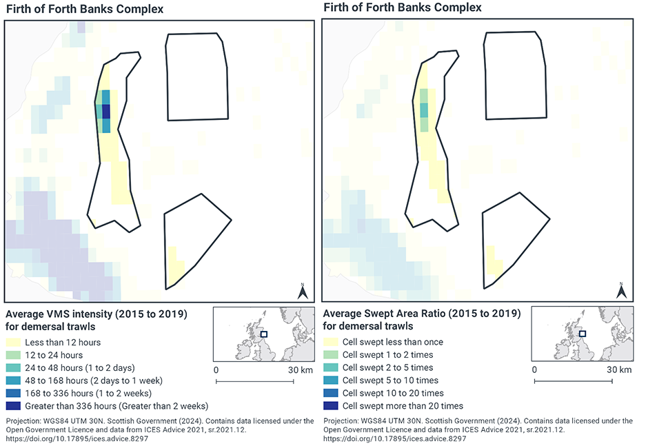
Based on the VMS, the highest intensity of demersal trawl activity within the NCMPA occurred in the Western area of the complex, with activity peaking in a single grid cell at greater than 36 hours per year per grid cell between 2015-2019 (Figure 2). The majority of the site has lower fishing intensity (less than 12 fishing hours per year per grid cell).
Swept-Area Ratio (SAR) information averaged over the same time period shows similar levels of fishing intensity as the VMS data (Figure 2).
3.2.4 Demersal Seines
Scottish Seine was the only seine gear type found to operate within the Firth of Forth Banks Complex NCMPA between 2015 and 2019 (Table 1). These seines target demersal fish.
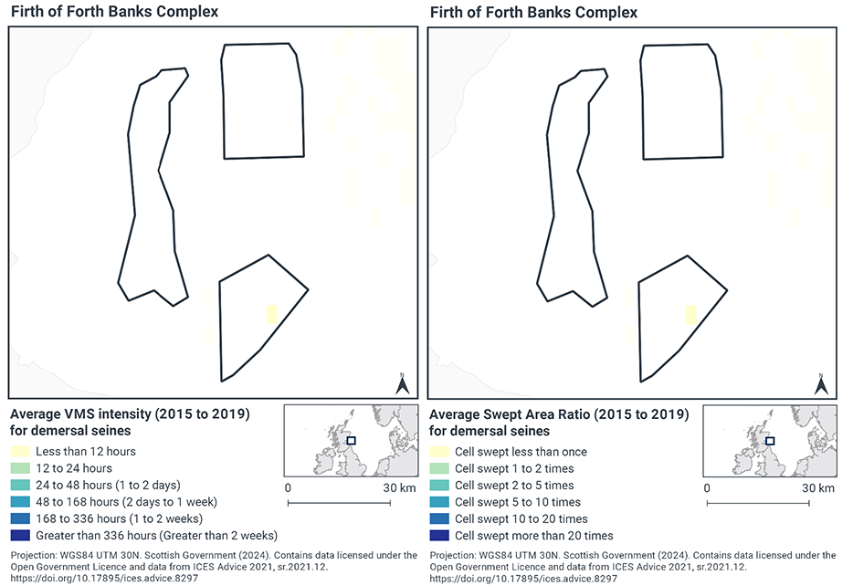
Based on the VMS, demersal seine activity within Firth of Forth Banks Complex NCMPA occurred within a small section of the southern area of the complex at less than 12 hours per year per grid cell (Figure 3) for a single grid cell. The VMS data showed that this activity only occurred in 2015 of the full assessment period (2015-2019).
Swept-Area Ratio (SAR) information averaged over the same time period shows similar patterns of fishing intensity as the VMS data Figure 3, showing the same area of the site swept less than once between 2015-2019.
3.2.5 Dredge
The aggregated gear method of dredge includes boat dredge and hydraulic dredge which operated within the Firth of Forth Banks Complex NCMPA between 2015 and 2019 (Table 1).
The target species for these gear types are molluscs. Recognising the significant differences in fishing methods, the pressures exerted by the different gears are still broadly similar for both dredge types, subsequently the aggregated gear type of ‘dredge’ was used to map activity from both gear types across the site.
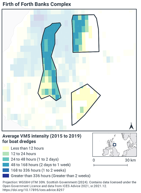
Based on the VMS, the highest intensity of dredge activity within NCMPA occurs in the Western area of the complex, with annual average activity peaking at 48 – 168 hours of activity per year per grid cell between 2015-2019 (Figure 4). The northern area of the complex also shows a greater level of fishing intensity across the western half. The majority of the southern complex has lower fishing intensity (less than 12 fishing hours per year per grid cell).
3.2.6 Pots and traps
Pots/traps/creels were the only demersal static gear activity found to occur within the Firth of Forth Banks Complex NCMPA between 2015 and 2019, (Table 1). The target species for these gear types are crustaceans.
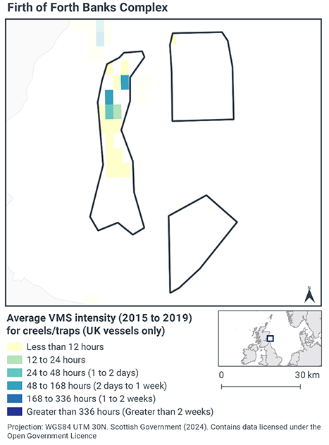
Based on the VMS, the vessel activity predominantly took place in the western area of the site complex, with two cells showing 48 – 168 hours of average annual fishing vessel activity occurring per year per grid cell between 2015-2019 (Figure 5). Although it is difficult to determine the amount of fishing effort (i.e. number of pots fished), it appears that the majority of the site had little to no fishing vessel activity occurring (less than 12 fishing hours per year per grid cell).
3.2.7 Summary of fishing activity within Firth of Forth Banks Complex NCMPA
Four aggregated fisheries gear groupings were detected within the site, consisting of demersal trawl, seine, dredge and traps/creels. The majority of activity undertaken involved fishing with dredges.
3.3 Fishing activity effects overview
The following sections explore the impacts of fishing activity within the Firth of Forth Banks Complex NCMPA that were identified as potentially capable of impacting the protected features. The pressures considered in the following sections are:
- Abrasion/disturbance of the substrate on the surface of the seabed;
- Changes in suspended solids (water clarity),
- Penetration and/or disturbance of the substrate below the surface of the seabed, including abrasion;
- Smothering a siltation rate changes (light) and;
- Removal of non-target species.
All five pressures, as exerted by demersal trawls, demersal seines and dredges were considered capable of impacting the ocean quahog aggregations and Offshore subtidal sands and gravels features within Firth of Forth Banks Complex NCMPA. The only pressure associated with traps/creels capable of impacting the features was abrasion/disturbance of the substrate on the surface of the seabed.
Given the similarity between ‘abrasion/disturbance of the substrate on the surface of the seabed’ and ‘penetration and/or disturbance of the substrate below the surface of the seabed’, these two pressures are considered together in the text below.
Information on the impacts of demersal trawls, demersal seines and traps/creels on the protected features is presented below and is informed by the JNCC and NatureScot Fisheries Management Guidance document for Arctica islandica, JNCC and NatureScot Fisheries Management Guidance document for Offshore subtidal sands and gravels, JNCC Marine Pressures-Activities Database v1.5 and fisheries management options paper
3.3.1 Impacts of demersal mobile gear on ocean quahog aggregations
Evidence suggests that ocean quahog (A. islandica) can be caught or damaged by beam trawls (Witbaard and Klein 1994; Klein & Witbaard 1993), with an individual pass of the gear causing around 20% mortality (Bergman and van Santbrink 2000). Population density has been found to be inversely related to beam trawling effort (Craeymeersch et al, 2000). There is some evidence that otter trawl doors may impact ocean quahogs by bringing them to the surface and larger individuals can be more affected than smaller bivalves (Rumohr & Krost 1991).
The physical effects of scallop dredging on seabed sediments are similar to those of beam trawls (penetration to depths >5 cm) and so the effects on ocean quahog are likely to be similar. However, hydraulic gears penetrate sediments more deeply than other gears and so could be expected to cause a greater mortality. The effects of hydraulic dredging on ocean quahogs can be long-lasting. Ragnarsson, Thorarinsdottir, & Gunnarsson, 2015 found that total direct and indirect loss of ocean quahog biomass within hydraulic dredge tracks due to fishing was 93%.
The JNCC and NatureScot Fisheries Management Guidance document for Arctica islandica states that demersal towed and hydraulic gears that penetrate the sediment (beam trawls, dredges and hydraulic gears including those operated by divers) are likely to reduce the abundance of ocean quahogs. The degree of impact will depend on the intensity of fishing.
Ocean quahog are classed as having medium sensitivity to the pressure removal of non-target species (including lethal) in FEAST[2]. Hamon et al. (2020) also report ocean quahog as being sensitive to demersal seine fishing due to their capture as bycatch in the southern North Sea, however, this assessment is associated with uncertainty due to the sampling technique not being representative of deep burrowing species and larger epifaunal species. Overall, demersal seines are likely to have a relatively lower impact on ocean quahog compared to other demersal towed gears, as the gear is lighter and has fewer penetrating gear components (i.e. no trawl doors or warps).
VMS data shows that only low levels of demersal seining takes place within Firth of Forth Banks Complex NCMPA, with the only records in the assessment period occurring in 2015. Dredging (boat dredge and hydraulic dredge) and demersal trawl occurred at comparatively higher levels predominantly in the western area of the site where limited records of ocean quahog are recorded.
Through physical impacts from gear interacting with the seabed, demersal trawl and dredges have the potential to hinder maintenance of favourable condition for the ocean quahog feature at current levels of activity. However, demersal seines alone, at current levels of activity are not considered to hinder the achievement of the conservation objectives for the feature. Accordingly, Scottish Ministers conclude that demersal trawls and boat dredges alone are capable of impacting the protected feature and, at current levels, would or might hinder the achievement of the conservation of objectives for the Firth of Forth Banks Complex NCMPA.
3.3.2 Impacts of demersal mobile gear on offshore subtidal sands and gravels
In general, the impact of demersal mobile gear on sand and gravel sediments is relatively well understood. The extent to which the gear impacts on sand and gravel sediments can vary considerably, according to the type of gear, the intensity of fishing and the sediment composition. Trawling and dredging tends to cause increased mortality of fragile and long-lived species and favour opportunistic, disturbance-tolerant species, however, the tolerance to disturbance is linked to the energy levels of the area.
In higher energy locations, fauna tend to be more adapted to disturbance and as a result tend to be more tolerant of fisheries related disturbance than in lower energy locations (Dernie et al., 2003; Hiddink et al., 2006; Kaiser et al., 2006). Stable gravels often support a ‘turf’ of fragile species which are easily damaged by trawling and recover slowly (Collie et al., 2005; Foden et al., 2010). EUSeaMap predicts a moderate level of energy at the seabed within Firth of Forth Banks Complex NCMPA, suggesting a lower sensitivity to the pressures to which the habitats are exposed. It is considered to be a relatively isolated system and localised hydrodynamics have a positive effect on productivity in the area (Scott et al., 2010).
Towed bottom fishing gears (including demersal trawls and seines) are used to catch species that live in, on or in association with the seabed and therefore are designed to remain in close contact with the seabed. That interaction with the seabed can lead to disturbance of the upper layers of the seabed. As a relative comparison of gear types, otter trawls tend to have less physical impact on the seafloor than the beam trawls (and dredges) with their heavy tickler chains, although the doors of an otter trawl do create recognisable scour of the seabed ((Hinz, Murray, Malcom, & Kaiser, 2012); (Polet & Depestele, 2010); (Lart, 2012);(Paschen, Richter, & Köpnick, 2000)).
As with demersal trawls and dredges, demersal seines may impact the structure and function of sedimentary habitats and the long-term survival of their associated species. There are currently no direct studies on the physical impacts of demersal seines. Modelling studies suggest that demersal seines have a large overall footprint (i.e. the surface area covered during one hour fishing) (Eigaard et al. 2016). Hiddink et al. (2017) suggest that depletion of biota is highly correlated with seabed penetration depth by trawls. Seines lack the heavy gear components (e.g. otter doors, trawl shoes) of other mobile demersal gears (Suuronen et al. 2012; Donaldson et al. 2010) and therefore, despite the relatively large footprint, impacts associated with penetration into the sediment are likely to be lower. Eigaard et al. (2016) modelled surface (<2cm) and subsurface (>2cm) impacts and found that demersal seines have some of the smallest proportions of subsurface impact.
The offshore subtidal sands and gravel feature is uniformly distributed across the full NCMPA (Figure 1). VMS data shows that only low levels of demersal seining takes place within Firth of Forth Banks Complex NCMPA, with the only records in the assessment period occurring in 2015. Dredging (boat dredge and hydraulic dredge) and demersal trawl occurred at comparatively higher levels predominantly in the western area of the site.
Through physical impacts from gear interacting with the seabed, demersal trawl and dredges have the potential to hinder the maintenance of favourable condition for the offshore subtidal sands and gravels feature, at current levels of activity. However, demersal seines alone, at current levels of activity are not considered to hinder the achievement of the conservation objectives for the feature. Accordingly, Scottish Ministers conclude that demersal trawls and boat dredges alone are capable of impacting the protected feature and, at current levels, would or might hinder the achievement of the conservation of objectives for the Firth of Forth Banks Complex NCMPA.
3.3.3 Impacts of demersal static gear (pots/traps/creels) on offshore subtidal sands and gravels and ocean quahog aggregations
Mechanical impacts of demersal static gear (e.g. weights and anchors hitting the seabed, hauling gear over seabed, rubbing / entangling effect of ropes) can damage some species (Eno et al., 1996). Other species appear to be resilient to individual fishing operations but the effects of high fishing intensity are unknown (Eno et al., 2001). Recovery will be slow (Foden et al., 2010) resulting in significant reduction or even loss of characteristic species. The individual impact of a single fishing operation may be slight but cumulative damage may be significant (Eno et al., 2001, Foden et al., 2010). Sensitivity to low intensity potting is considered low (Hall et al., 2008, JNCC and Natural England, 2011).
Intensity of demersal static gear fishing in this site is low and it is considered unlikely that this activity poses a significant risk to the long-term natural distribution, structure and functions of the habitats or the long-term survival of associated species. If fishing intensity were to increase to high levels in the future, there is a risk of significant impact to the structure and functions of the habitats.
Given the evidence above, the impacts of abrasion/disturbance of the substrate on the surface of the seabed from demersal static gear (traps/creels) alone within Firth of Forth Banks Complex NCMPA at current activity levels would not hinder maintaining favourable condition for ocean quahog or offshore subtidal sands and gravels feature. Accordingly, Scottish Ministers conclude that demersal static gear (traps/creels) alone and at current activity levels would not hinder the achievement of the conservation objectives for the Firth of Forth Banks Complex NCMPA.
3.4 Part B Conclusion
The assessment of impact of fishing pressures at current activity levels on ocean quahog aggregations features and the supporting habitat of offshore subtidal sands and gravels of Firth of Forth Banks Complex NCMPA has indicated that demersal trawling activities would or might hinder the achievement of the conservation objectives for the site.
Demersal seine and demersal static (traps/creels) activities will not hinder the achievement of the conservation objectives for ocean quahog aggregations or the supporting offshore subtidal sands and gravels at current levels of activity.
Scottish Ministers conclude that management measures to restrict demersal trawling and dredging are required within Firth of Forth Banks Complex NCMPA. Section 6 contains further details on potential measures.
Scottish Ministers conclude that the remaining fisheries activities (demersal seines and traps/creels), when considered in isolation at current levels, will not hinder the achievement of the conservation objectives of the site at current levels of activity.
Contact
Email: marine_biodiversity@gov.scot
There is a problem
Thanks for your feedback