Draft Fisheries Assessment – Firth of Forth Banks Complex NCMPA: Fisheries management measures within Scottish Offshore Marine Protected Areas (MPAs)
These assessments look at the fishing activity occurring within each offshore MPA and SAC and assess the potential impacts of this activity on the protected features within each site. This assessment is for Firth of Forth Banks Complex NCMPA.
4. Part C Assessment – In Combination Assessment
Part C of this assessment considers the cumulative impacts, which may occur over space and time, in relation to activities occurring within the MPA. Activities assessed in this section include the following:
- Fishing activity/pressure combinations which were excluded in Part A of this assessment as not being capable of impacting;
- Fishing interactions assessed in Part B but that would not hinder the conservation objectives for the site; and
- Activities occurring within Firth of Forth Banks Complex NCMPA that are not related to fishing.
Demersal trawls and dredges have been identified in Part B as requiring management and will therefore not be considered in Part C.
4.1 In-combination assessment overview
4.2 Other offshore region activities screening
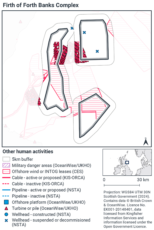
To determine activities, not related to fishing activities, to be included within this part of the assessment, a distance of 5 km was selected as suitable to capture any potential source receptor pathways that could impact the site in combination with effects of the fishing activities assessed. A 5 km buffer was therefore applied to the site boundary to identify relevant activities.
Activities not related to fishing activities were identified using the Scottish Government’s marine mapping tool. The JNCC Conservation Advice package, and other resources on the JNCC Site Information Centre for Firth of Forth Banks Complex NCMPA, were also screened for activities occurring in the site that should be considered in the in-combination assessment.
The map to display offshore region activities (see Figure. 6) was derived from OceanWise’s Marine Themes Vector data (July 2023 version), Crown Estate Scotland leases (September 2023 version), Kingfisher Information Services Offshore Renewable Cable Awareness (KIS-ORCA, as of December 2023 held under licence) and North Sea Transition Authority (NSTA, as of December 2023, data held under Oil and Gas Authority open licence). The Marine Themes “Industrial” was filtered to show offshore region platforms, wellheads, piles, turbines, cables, and pipelines. Features marked as “not in use”, “not present”, “decommissioned”, or “removed” were excluded. The “Administrative” data were filtered to only show military exercise areas which included danger areas.
4.3 Other offshore region activities occurring within Firth of Forth Banks Complex NCMPA
The screening exercise using the Scottish Government’s marine mapping tool identified a number of other offshore activities taking place within the site or within 5km of the site boundary. The activities found were three decommissioned well heads, multiple turbine or piles within one overlapping wind farm lease site and two potential sites for wind farm lease. A Ministry of Defence (MOD) Military Practice Area overlaps with a small part of the southern side of the Wee Bankie and the western side of the Berwick Bank component of the MPA.
The active leased wind farm site overlapping the northern area of the site is
Berwick Bank Wind Farm. This project is in the planning and design stage and still subject to the relevant consents and approval for construction and impacts assessed accordingly. As there is currently no infrastructure, or proposed activity in place for this site, it was not deemed to have potential for in-combination effects at this point in time.
Multiple turbines are in place at the Seagreen wind farm which overlaps small sections of two areas within the complex. This wind farm became fully operational in October 2023. Seagreen was originally consented for up to 150 turbines. The remaining 36 turbines are still to be built. These will be subject to the relevant consents and approval for construction and impacts assessed accordingly. A designated cable route was identified for Seagreen wind farm which crossed the north of the western site of the NCMPA complex, (not shown in Figure 6, map available online via North Sea Transition Authority). This cable is in-situ and has been subject to the relevant licensing and consenting process.
Although 2010 data on military activities within Military Practice Areas suggests
seabed, surface and sub-surface activities occurred in the region, discussion with the
Ministry of Defence suggests this area is primarily used for surface activities such as vessel transiting that is unlikely to interact with the protected features. The MOD will incorporate Nature Conservation MPAs into their Environmental Protection Guidelines (Maritime) of their Marine Environmental and Sustainability Assessment Tool, and will use JNCC guidelines to manage their activities in a way that will not impact the features achieving their conservation objectives.
4.4 Potential pressures exerted by fishing and other activities
To identify the specific pressures that the activities exert on the Firth of Forth Banks Complex NCMPA features, the JNCC Marine Pressures-Activities Database (PAD) v1.5 2022 was used. The JNCC fisheries management options paper for Firth of Forth Banks Complex NCMPA lists renewable energy as a licensable activity and seabed, sea surface and sub-surface activity from Ministry of Defence has activities considered capable of impacting the protected features.
The military activity undertaken within the identified practice area is unlikely to interact with the protected features and JNCC consider that no additional management is required. Should seabed activities occur in future, JNCC anticipate that management will be coordinated through the Ministry of Defence Environmental Protection Guidelines.
Risks associated with offshore wind operation and maintenance were assessed for the active turbines and power cable within the site. The JNCC PAD indicated twelve pressures to be of a medium-high risk. Those that are considered a low risk are not assessed.
The ten pressures associated with offshore wind operation and maintenance are:
- Abrasion/disturbance of the substrate on the seabed
- Barrier to species movement;
- Changes in suspended solids (water clarity)
- Collision ABOVE water with static or moving objects not naturally found in the marine environment (e.g., boats, machinery, and structures)
- Penetration and/or disturbance of the substrate below the surface of the seabed, including abrasion;
- Habitat structure changes – removal of substratum (extraction);
- Physical change (to another seabed type)
- Physical change (to another sediment type)
- Physical loss (to land or freshwater habitat)
- Water flow (tidal current) changes, including sediment transport considerations
- Visual disturbance and;
- Smothering and siltation rate changes (Light).
Demersal seine and traps/creels activity which took place within the site was assessed within Part B of this assessment as having no impact to the protected features and are therefore considered within Part C.
Four of the twelve identified pressures from offshore wind activity overlap with those exerted by demersal seines. These are abrasion/disturbance of the substrate on the seabed, changes in suspended solids (water clarity), smothering and siltation (light) and penetration and/or disturbance of the substrate below the surface of the seabed, including abrasion. These pressures will be assessed in section 4.5. Abrasion/disturbance of the substrate on the seabed was the only pressure identified which overlapped with those exerted by demersal static gear within the site (traps/creels).
4.5 Significance of effects/impact to protected features
For the in-situ power cable, construction on this is completed and therefore pressures relating to operation and maintenance were assessed. These pressures may occur where the cable needs to be reburied or uncovered for repair. The relevant pressure here are abrasion/disturbance, changes in suspended solids and penetration and/or disturbance of substrate below the surface of the seabed.
The frequency of the activity will be very low. Usually, free-swimming burial machines are deployed for repair and maintenance to shallow bury exposed sections of cable into the seabed. Though modern equipment and techniques reduce the re-suspension of sediment during cable burial, repair or removal, an increase in suspended sediment will occur but the magnitude depends on the silt fraction and background levels. Usually, free-swimming ROV burial machines are deployed for repair and maintenance to shallow bury exposed sections of cable into the seabed.
As the turbines are in situ and therefore not subject to pressures related to laying or decommissioning, the pressures identified in section 4.4 may occur through regular vessel movement, vessel discharges, rotor sweep, lighting, presence of turbine and foundation structures. This may also include use of jack up barges for maintenance and deposition of additional scour protection.
Some or all of the protected features of the site are considered to be sensitive to the four pressures exerted by offshore wind activity and power cable operation ana maintenance within the site which are also exerted by demersal seines identified above.
Demersal seine activity occurred at a very low level within the site with a limited number of hours recorded in 2015 only. This activity occurred in the southern area of the site only, therefore no overlap in activity was identified. When taking into account the additional pressure exerted by fishing activity, in combination with pressures exerted by activity around the turbines, there is likely to be no to minimal increase in pressure.
All these pressure-feature interactions, at current activity levels were not considered likely to impact the protected features of the site. When taking into account with the pressures exerted by offshore wind and power cable operation and maintenance with the pressures exerted by demersal seine and pots and traps activity, as the frequency of all the aforementioned activity is considered to be very low, no further management is considered.
Subsequently, the assessment did not identify any in-combination activities that were considered likely to impact the protected features of the site of Firth of Forth Banks Complex NCMPA.
4.6 Part C conclusion
Scottish Ministers conclude that the remaining fishing activities (demersal seine and traps/creels) in-combination with other relevant activities will not hinder the achievement of the conservation objectives for Firth of Forth Banks Complex NCMPA.
Contact
Email: marine_biodiversity@gov.scot
There is a problem
Thanks for your feedback