Draft Fisheries Assessment – Geikie Slide and Hebridean Slope NCMPA: Fisheries management measures within Scottish Offshore Marine Protected Areas (MPAs)
These assessments look at the fishing activity occurring within each offshore MPA and SAC and assess the potential impacts of this activity on the protected features within each site. This assessment is for Geikie Slide and Hebridean Slope NCMPA.
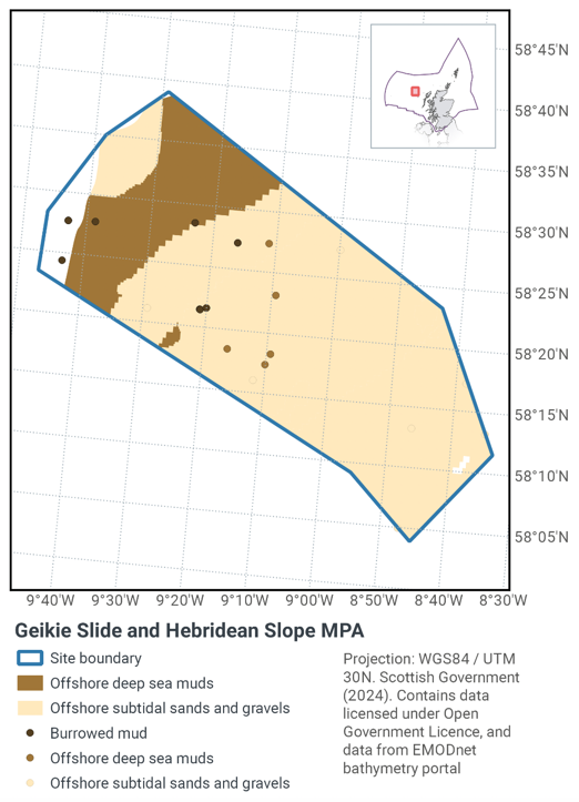
1. Introduction
1.1 Scope of the Geikie Slide and Hebridean Slope NCMPA assessment
The geographic scope if this assessment covers the whole of the Geikie Slide and Hebridean Slope NCMPA (Figure 1). The purpose of this assessment is to determine whether the current levels of fishing activities would or might hinder the conservation objectives of Geikie Slide and Hebridean Slope NCMPA and to identify options for management measures.
In this assessment, the Scottish Ministers use the best available evidence to review the site characteristics and current fishing activity (Part A), both taken alone and in combination with other relevant activities (Part C), to determine if the fishing activities are capable of impacting the protected features (burrowed mud including sea-pens), offshore deep-sea muds and offshore sands and gravels). Any fishing activities capable of impacting the protected features, either alone or in combination with other relevant activities, are considered further to assess whether they would or might hinder the achievement of the conservation objectives (Part B).
Where there is the potential for the achievement of the conservation objectives to be hindered, management measures are identified for the site by the Scottish Ministers. These measures are considered in light of the conservation objectives, biological characteristics, current fishing, other activity levels and existing fisheries restrictions for Geikie Slide and Hebridean Slope NCMPA. A final decision on which measures, if any, are to be adopted, will follow upon a statutory consultation exercise and will take into account all relevant statutory obligations incumbent upon Scottish Ministers.
A methodology document has been prepared to aid understanding of these assessments.
1.2 Site Description
Located to the north-west of Scotland, the Geikie Slide and Hebridean Slope NCMPA (Figure 1.) follows the descent of the seabed from a depth of 200 m on the Hebridean continental shelf into the deep-sea of the Rockall Trough. Habitats within the MPA vary down the slope with the descent into deeper, calmer water. The purpose of the MPA is to represent variation in sandy, muddy and gravelly habitat types, and the animal communities they support, with depth. The Geikie Slide is a submarine landslide of geological importance, named after the famous Scottish geologist, Sir Archibald Geikie. The Hebridean continental slope is believed to be significant for the health of Scotland's seas because of the way it influences the movement of water currents which bring a plentiful supply of food to the area.
Habitats within the MPA vary down the slope with the descent into deeper water. The sand and gravel habitat on the continental shelf continues down the slope changing to mud as the depth increases. The mud is characterised by the burrows formed by animals such as mud shrimp and deep-sea crabs. Along the bottom of the slope, a range of animals are present that tolerate the environmental conditions of the deep sea. A diverse range of sea life can be found living in and on the mud, including sea urchins, sea spiders, and deep-sea worms. The area is also a breeding ground for commercially important fish such as blue ling. The Hebridean slope more broadly is thought to have functional significance to the health and biodiversity of Scotland's seas in the way that it serves to increase water-column mixing and subsequently a rise in levels of biological productivity. Large-scale slides such as the Geikie Slide are considered characteristic geodiversity features along the Scottish continental slope.
The Geikie Slide and Hebridean Slope NCMPA has been designated for the following protected features:
- Burrowed mud
- Offshore deep-sea mud
- Offshore subtidal sands and gravels
- Continental slope
- Geodiversity feature – slide deposits and slide scars
The conservation objectives for the protected features in the Geikie Slide and Hebridean Slope NCMPA are that the protected features:
- so far as already in favourable condition, remain in such condition; and
- so far as not already in favourable condition, be brought into such condition, and remain in such condition.
With respect to burrowed mud, offshore deep-sea mud, and offshore subtidal sand and gravel features this means that:
- its extent is stable or increasing; and
- its structures and functions, its quality, and the composition of its characteristic biological communities are such as to ensure that it is in a condition which is healthy and not deteriorating.
With respect to the continental slope feature this means that:
- its extent, distribution and structure of that feature is maintained,
- the function of the feature is maintained so as to ensure that it continues to support its characteristic biological communities and their use of the site for, but not restricted to, feeding, courtship, spawning, or use as nursery grounds; and
- the processes supporting that feature are maintained.
With respect to the geodiversity features this means that:
- its extent, component elements and integrity are maintained;
- its structure and functioning are unimpaired; and
- its surface remains sufficiently unobscured for the purposes of determining with the conditions in the points above.
For burrowed mud (sea-pens and burrowing megafauna), offshore deep-sea muds, and offshore sands and gravels, the feature condition has been assessed by JNCC as being 'Unfavourable'. Forthe features continental slope, slide deposits and slide scars representative of the Geikie Slide Key Geodiversity Area, the feature condition has been assessed by JNCC as being 'Favourable'.
More information regarding the designation of the Geikie Slide and Hebridean Slope NCMPA is available in the Designation Order.
More information regarding the conservation objectives and feature condition for the protected features of Geikie Slide and Hebridean Slope NCMPA is available within the site's Conservation Advice package.
With regards to the scope of this assessment, JNCC considers that the large-scale feature (continental slope) and the geological / geomorphological features are unlikely to be impacted by fishing activities within the site. As such, these features are not considered further in this assessment.
1.3 Activities assessed
The assessments consider the impact of fisheries activities at each MPA in terms of the conservation objectives stated for the protected sites. This was deemed appropriate, in order to assist in identifying potential management measures.
In this context, the implications of the fishing activity in view of the conservation objectives for the MPA are being assessed through the fisheries screening stage (Part A), the fisheries assessment (Part B), and the in combination assessment (Part C).
Fisheries assessments use the best available evidence to fully consider potential impacts of commercial fishing activity, and in-combination (cumulative) effects with other activities, against the conservation objectives for the site. If the assessment concludes that use of certain fishing gear types would or might hinder the achievement of the conservation objectives of the site, management measures will be considered.
Commercial sea fishing activity has the potential to vary in nature and intensity over time. This assessment considers fishing activity based on activity levels and type between 2015-2019. This date range was considered to provide the best available data on current fishing activity levels for the assessment. Using a five year date range provides an average view of fishing activity within the site; latter years (2020 – 2021) were not considered representative of regular fishing activity due to the Covid pandemic. The selected date range (2015 – 2019) was used consistently across all assessments within the consultation package. Changes in fishing activity after this time period may be considered in future reviews of this assessment (see Section 6).
Contact
Email: marine_biodiversity@gov.scot
There is a problem
Thanks for your feedback