Draft Fisheries Assessment – Geikie Slide and Hebridean Slope NCMPA: Fisheries management measures within Scottish Offshore Marine Protected Areas (MPAs)
These assessments look at the fishing activity occurring within each offshore MPA and SAC and assess the potential impacts of this activity on the protected features within each site. This assessment is for Geikie Slide and Hebridean Slope NCMPA.
3. Part B Assessment – Fisheries Assessment
3.1 Fisheries assessment overview
Part B of this assessment considers if there would be a risk of the fishing activities identified in Part A, at the levels identified in the relevant date range, hindering the achievement of the conservation objectives for the MPA. This section considers whether management measures may be needed for these fishing activities, in order to consider whether, and if so, which, management measures might be appropriate for the MPA, taking into account all relevant statutory obligations incumbent upon the Scottish Ministers.
The fishing activities and pressures identified in Part A which have been included for assessment in Part B, are demersal trawls and anchored nets/lines, and the pressures abrasion/disturbance of the substrate on the surface of the seabed; penetration and/or disturbance of the substrate below the surface of the seabed, including abrasion; changes in suspended solids (water clarity); removal of non-target species; removal of target species; and smothering and siltation rate changes (light).
3.2 Fishing activity descriptions
3.2.1 Existing management within Geikie Slide and Hebridean Slope NCMPA
In compliance with Part 5, Chapter 7 of The Common Fisheries Policy and Aquaculture (Amendment etc.) (EU Exit) Statutory Instrument (S.I.) 2019 No. 753, there is a ban on the use of all bottom-contacting mobile gear below 800 m depth across all UK waters. This applies across the area of Geikie Slide and Hebridean Slope NCMPA where the depth falls below 800 m. Part 5 Chapter 7 of S.I. 2019, No. 753 also implements restrictions on fishing between 400 m and 800 m where Vulnerable Marine Ecosystems (VMEs) are present, or are likely to occur. These rules aim to minimise the impact of fishing activities on VMEs. Under The Common Fisheries Policy and Animals (Amendment etc.) (EU Exit) Regulations 2019 S.I. 2019, No. 1312 (amending S.I. 2019, No. 753) there is a prohibition on the use of bottom-set gillnets, entangling nets, and trammel nets at depths greater than 200 m for the protection of deep-water shark species. These protective measures are also applied in the North-East Atlantic Fisheries Commission (NEAFC) technical measures regulatory area (beyond European Union waters) through the same Statutory Instrument. The use of gillnets is only permanently restricted within the western most end of the site, with the central portion being under seasonal restrictions. In the eastern end of the site no fisheries restrictions were identified.
3.2.1 Fishing activity within Geikie Slide and Hebridean Slope NCMPA
The Geikie Slide and Hebridean Slope NCMPA overlaps ICES rectangles 45E0, 45E1 and 46E0 in the West of Scotland (ICES Division 6a), in the Hebrides and Bailey regions. The main gear types for UK vessels are midwater trawls, hooks and lines and demersal trawls, predominantly targeting mackerel and hake.
The VMS-based estimates and ICES rectangle landings statistics indicate that over-12 m midwater trawls, hooks and lines and demersal trawls are the only UK vessels that operated within the site over the period 2015-2019.
For the over-12 m vessels, based on the VMS data from 2015-2019, midwater trawls operate throughout the site, with slightly higher frequency at the eastern end. Hook and line activity is concentrated in the central portion of the site, with demersal trawls most frequent in two regions, one towards the eastern end of the site and another that follows the continental slope depth contour.
In addition to UK activity, vessels from Norway (35 vessels), Ireland (32 vessels), Spain (31 vessels), France (28 vessels), Faroes (12 vessels), Denmark (9 vessels), Netherlands (8 vessels), Germany, Lithuania and Poland (number of vessels cannot be disclosed) may also operate in the site, based on VMS data from 2015-2020. However, it is not clear what gear types these vessels operate, nor whether they were actively fishing at the time.
3.2.2 Demersal trawls
The aggregated gear method of demersal trawls includes multiple gears that operated within the Geikie Slide and Hebridean Slope NCMPA between 2015 and 2019. These include bottom otter trawl, multi-rig trawls, pair trawl, and bottom trawls (not specified) (Table 1). The target species for these gear types are demersal fish, molluscs or nephrops. Similar pressures are exerted by the different gears used for demersal trawling, subsequently the aggregated gear type of 'demersal trawl' was used to map activity across the site.
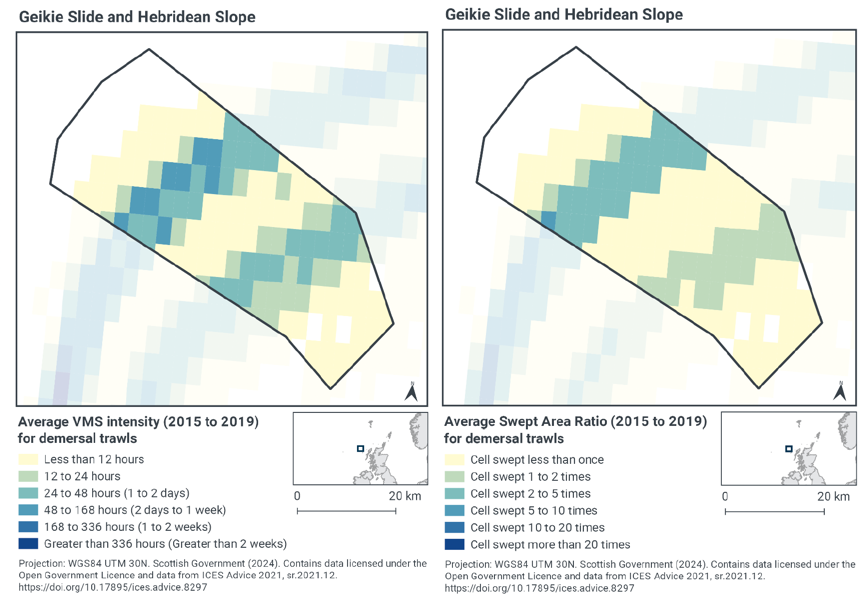
Based on the VMS, the highest intensity of demersal trawl activity within Geikie Slide and Hebridean Slope NCMPA occurs across two parts of the site, with activity peaking at 48 - 168 hours per year per grid cell between 2015-2019 for the deeper section (to the south-west) and 24 - 48 hours per year per grid cell for the same period over the shallower section (to the north-east) (Figure 2). The level of activity reduces away from these two strips, resulting in the shallowest (south-east) part of the site having less than 12 hours of activity per year per grid cell between 2015-2019, and the deepest (north-west) part of the site having no demersal trawling activity within this period. This pattern of activity reflects the tendency for vessels tend to fish along the Scottish continental shelf, and Geikie Slide and the Hebridean Slope MPA is located on the slope at a perpendicular orientation, so fishing occurs through the site (along the shelf).
Swept-Area Ratio (SAR) information averaged over the same time period shows similar patterns of fishing intensity as the VMS data (Figure 2). The deeper section of activity (to the south-west) was swept 2 – 5 time per year between 2015-2019 (with a small area being swept 5 – 10 times), whilst the shallower section (to the north-east) was swept 1 – 2 times per year over the same period. The SAR reduced away from these areas, with the shallowest (south-east) part of the site having low SAR values, being swept less than once per year between 2015-2019, and the deepest (north-west) part of the site not being swept at all.
The areas of concentrated demersal trawl activity corresponds to the area of Offshore subtidal sands and gravels within the site (Figure 1).
3.2.3 Anchored nets and lines (line fishing)
Longlines (not specified) and set longlines operated within the Geikie Slide and Hebridean Slope NCMPA between 2015 and 2019 (Table 1). The target species for these gear types are demersal fish.
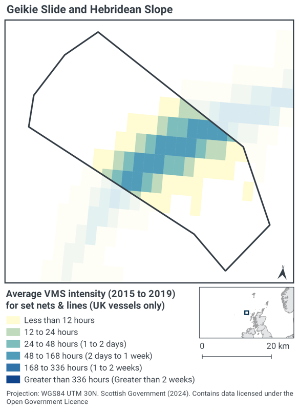
Based on the VMS, the highest intensity of longline activity within Geikie Slide and Hebridean Slope NCMPA occurs over the central part of the site, with activity peaking at 48-168 hours per year per grid cell between 2015-2019 (Figure 3). The level of activity reduces away from this central strip, resulting in the shallowest (south-east) and deepest (north-west) parts of the site having no line fishing activity. This pattern of activity reflects the tendency for vessels to fish along the Scottish continental shelf, and Geikie Slide and the Hebridean Slope MPA is located on the slope at a perpendicular orientation, so fishing occurs through the site (along the shelf).
The area of concentrated line fishing activity corresponds to the area of offshore subtidal sands and gravels within the site (Figure 1).
3.2.4 Summary of fishing activity within Geikie Slide and Hebridean Slope NCMPA
Fishing activities using demersal trawls and anchored nets/lines all occur within Geikie Slide and Hebridean Slope NCMPA.
This activity is concentrated over the central area of the site, corresponding to the tendency for vessels to fish along the Scottish continental shelf. Demersal trawl activity occurs across two areas of the site, and longline activity occurs across the site in between these areas. The activity of both gear types overlaps with the area of offshore subtidal sands and gravels. No activity occurs within the deepest part of the site, likely due to the existing restrictions in place (see Section 3.2.1 above).
3.3 Fishing activity effects overview
The following sections explore the impacts associated with fishing activity (demersal trawls and anchored nets/lines) within the Geikie Slide and Hebridean Slope NCMPA that were considered capable of impacting the burrowed mud, offshore deep-sea mud and offshore subtidal sands and gravels features. The pressures considered in the following sections are:
- Abrasion/disturbance of the substrate on the surface of the seabed;
- Changes in suspended solids (water clarity);
- Penetration and/or disturbance of the substrate below the surface of the seabed, including abrasion;
- Smothering and siltation rate changes (light);
- Removal of target species; and
- Removal of non-target species.
All six pressures, as exerted by demersal trawls were considered capable of impacting the protected features. For anchored nets/lines only abrasion/disturbance of the substrate on the surface of the seabed; removal of target species and removal of non-target species were considered capable of impacting the features.
Given the similarity between 'abrasion/disturbance of the substrate on the surface of the seabed' and 'penetration and/or disturbance of the substrate below the surface of the seabed', these two pressures are considered together in the text below.
In the absence of a detailed JNCC Advice on Operations spreadsheet for this site, the detailed pressure information for this section is based on information from the Management Options Paper for Geikie Slide and Hebridean Slope NCMPA (2014), JNCC PAD and FeAST.
3.3.1 Impacts of demersal mobile gear on Geikie Slide and Hebridean Slope NCMPA features
Lower energy deep water locations, such as in the Geikie Slide and Hebridean Slope NCMPA, with sedimentary habitats tend to be more stable and their associated fauna less tolerant of disturbance than high energy sites (Hiddink et al. 2006; Kaiser et al. 2006). Studies have shown that areas of mud habitats (which includes offshore deep-sea mud and burrowed mud) subject to mobile fishing activity, support a modified biological community with lower diversity, reduction or loss of long-lived filter-feeding species and increased abundance of opportunistic scavengers (Ball et al. 2000; Tuck et al. 1998). This effect is often greatest in the more heavily fished offshore areas suggesting that impact is related to the intensity of fishing (Ball et al. 2000). Furthermore, modelling studies suggest that the greatest impact is produced by the first pass of a trawl (Hiddink et al. 2006).
Trawling on these deep-sea sedimentary habitats can cause significant decreases in organic matter content, slower organic carbon turnover, reduced meiofauna abundance, biodiversity and nematode species richness (Pusceddu et al. 2014). The use of penetrative gear over soft substrates, can further cause removal or re-stratification of sediment layers and homogenisation of sedimentary habitats (Goode et al. 2020; Martín et al. 2014). Sediment resuspension can also occur, resulting in increases in turbidity and risks of smothering to benthic fauna (Martín et al. 2014). The physical integrity of the seabed can also be altered, becoming flattened in trawled areas with less bioturbation (fewer and smaller burrows, mounds and faunal tracks) compared to non-trawled areas (Ramalho et al. 2017). Other physical impacts include scars created by the trawl doors (Goode et al. 2020). These alterations to the seafloor structure can be long lasting, with scars remaining visible for more than 10 years after trawling ceases (Goode et al. 2020). Based on the evidence above, it is likely that mobile bottom contact gear will impact the extent and distribution, and structure and function of burrowed mud (including sea-pens) and offshore deep-sea mud features, including the sediment composition and finer scale topology.
Sea-pens associated with burrowed mud and offshore deep-sea mud habitats, are likely to have medium sensitivity to bycatch, abrasion and penetration pressures and are highly sensitivity to heavy levels of smothering (up to 30 cm) (Last et al. 2020a, 2020b). Although some sea-pen species have behavioural adaptations and can recover from minor damage (Kenchington et al. 2011; Malecha and Stone, 2009; Troffe et al. 2005), high levels of bycatch in trawl nets can occur and incidental mortality is a concern for those remaining on the seafloor (Last et al. 2020a, 2020b). Otter trawls have been found to catch the greatest frequency of sea-pens compared to other gear types, e.g., twin trawl, triple trawl, shrimp trawl, and static gears (Wareham and Edinger, 2007). Dredges can also catch high numbers of sea-pens (Pires et al. 2009). A number of studies indicate that the abundance of sea-pen species are negatively correlated with bottom trawling (Adey, 2007; Buhl-Mortensen et al. 2016; Hixon and Tissot, 2007).
In addition to sea-pens, nephrops may be an important component of the benthic community associated with offshore deep-sea mud and burrowed mud. Any fisheries, such as mobile bottom-contact gears, that greatly alter the abundance or size composition of this species may therefore have a negative impact on the biological structure of the features. This evidence further suggests that mobile bottom contact gear will likely impact the biological assemblages and biological structure of the features, resulting in impacts to the extent and distribution, and the structure and function of the burrowed mud (including sea-pens) and offshore deep-sea mud habitat features.
Similar to the above, trawling on offshore subtidal sands and gravelsalso can cause significant decreases in organic matter content, slower organic carbon turnover, reduced meiofauna abundance, biodiversity and nematode species richness (Pusceddu et al. 2014). Stable offshore subtidal sands and gravels often support a 'turf' of fragile species which are easily damaged by trawling and recover slowly (Collie et al. 2005; Foden et al. 2010). Trawling and dredging tends to cause increased mortality of fragile and long-lived species and favour opportunistic, disturbance-tolerant species (Bergmann and Van Santbrink, 2000; Eleftheriou and Robertson, 1992). Some particularly sensitive species may disappear entirely (Bergmann and Van Santbrink, 2000). The net result is benthic communities modified to varying degrees relative to the un-impacted state (Bergmann and Van Santbrink, 2000; Kaiser et al. 2006). The use of penetrative gear over soft substrates, can further cause removal or re-stratification of sediment layers and homogenisation of sedimentary habitats (Goode et al. 2020; Martín et al. 2014).
Sediment resuspension can also occur, resulting in increases in turbidity and risks of smothering to benthic fauna (Martín et al. 2014). Other physical impacts include scars created by the trawl doors and dislodgment or removal of boulders, rocks and biogenic substrates and such impacts can be long lasting (Goode et al. 2020). Based on this evidence, it is likely that mobile bottom contact gear will impact the extent and distribution, and structure and function of offshore subtidal sands and gravels, including the sediment composition, finer scale topology, biological assemblages, and biological structure.
Activity from demersal trawling within Geikie Slide and Hebridean Slope NCMPA occurs at moderate-high levels and the protected habitat features of the site, as described above, are highly sensitive to demersal mobile gear activity.
Given the evidence above and through physical impacts of gear interacting with the seabed, demersal mobile gear carries the risk of hindering the restoration of the burrowed mud, offshore deep-sea muds, and offshore subtidal sands and gravels features. Accordingly, Scottish Ministers conclude that demersal mobile gear alone are capable of impacting the protected features and, at current activity levels, would or might hinder the achievement of the conservation objectives for Geikie Slide and Hebridean Slope NCMPA.
3.3.2 Impacts of static demersal gear (anchored nets/longlines) on Geikie Slide and Hebridean Slope NCMPA features
Offshore subtidal sands and gravels within subtidal areas are not considered to be sensitive to the level of abrasion caused by static demersal gears, with minimal impact on the faunal communities and seabed structure (Tillin et al. 2010; Tyler‐Walters et al. 2009). However, in lower energy deep water locations, such as in the Geike Slide and Hebridean Slope MPA, sediments tend to be more stable and their associated fauna less tolerant of disturbance (Hiddink et al. 2006; Kaiser et al. 2006). Bycatch of associated communities, such as invertebrates also poses a risk. Overall, the risk from low levels of static bottom contact gear on the abundance and distribution, and the structure and function of offshore subtidal sands and gravels is likely to be limited, however higher levels of fishing activity will pose a greater risk to the features and their attributes.
Bycatch of deep-sea sea-pen species (associated with offshore deep-sea mud and burrowed mud) has been recorded in gillnets and longlines, although at a lower frequency than otter trawls (Wareham and Edinger, 2007). Longline hooks of varied sizes can catch specimens of all size ranges, including larger specimens (de Moura Neves et al. 2018). If static fishing activity is low, direct impact on the habitat is likely to be minimal and seabed structure is likely to be maintained in a slightly modified state (Adey, 2007). In addition to sea-pens, nephrops may be an important component of the benthic community associated with offshore deep-sea mud and burrowed mud. Any fisheries, such as static gears, that greatly alter the abundance or size composition of this species may therefore have a negative impact on the biological structure of the features.
Based on the evidence above, the risk from low levels of static bottom contact gear on the abundance and distribution, and the structure and function of burrowed mud (including sea-pens) and offshore deep-sea mud is likely to be limited, however higher levels of fishing activity will pose a greater risk to the features and their attributes. Activity from longlines within Geikie Slide and the Hebridean Slope MPA occurs moderate-high levels, however the protected habitat features of the site, as described above, are not considered to be sensitive to longline activity.
Given the evidence above, demersal static gear (longlining) alone at currently levels of activity would not hinder the restoration of the burrowed mud, offshore subtidal sands and gravels, or offshore deep-sea muds feature, such that the extent and distribution, structure and function and supporting processes are restored within Geikie Slide and Hebridean Slope NCMPA. Accordingly, Scottish Ministers conclude that longlining alone at currently levels of activity will not hinder the conservation objectives for Geikie Slide and the Hebridean Slope MPA.
3.4 Part B conclusion
The assessment of impact of fishing pressures at current activity levels on offshore deep-sea muds, offshore subtidal sands and gravels, and burrowed mud features within Geikie Slide and Hebridean Slope NCMPA has indicated that demersal trawling activities would or might hinder the achievement of the conservation objectives for the site. Static demersal gear, specifically longlining activities will not hinder the achievement of the conservation objectives for offshore deep-sea muds, offshore subtidal sands and gravels, and burrowed mud features, at current levels of activity. As such, Scottish Ministers concludes that management measures are required to restrict demersal trawling within Geikie Slide and Hebridean Slope NCMPA. Section 5 contains further details on potential measures.
Scottish Ministers conclude that the remaining fisheries activities (anchored nets/longlines), when considered in isolation and at current levels, will not hinder the achievement of the conservation objectives for Geikie Slide and Hebridean Slope NCMPA.
Contact
Email: marine_biodiversity@gov.scot
There is a problem
Thanks for your feedback