Draft Fisheries Assessment – Geikie Slide and Hebridean Slope NCMPA: Fisheries management measures within Scottish Offshore Marine Protected Areas (MPAs)
These assessments look at the fishing activity occurring within each offshore MPA and SAC and assess the potential impacts of this activity on the protected features within each site. This assessment is for Geikie Slide and Hebridean Slope NCMPA.
4. Part C Assessment- In combination assessment
4.1 In combination assessment overview
Part C of this assessment considers the cumulative impacts, which may occur over space and time, in relation to activities occurring within the MPA. Activities assessed in this section include the following:
- Fishing activity/pressure combinations which were excluded in Part A of this assessment as not being capable of impacting the feature
- Fishing interactions assessed in Part B but that would not hinder the conservation objectives for the site; and
- Activities occurring within Geikie Slide MPA that are not related to fishing.
Fishing activities including demersal trawls have been identified in Part B as requiring management and will therefore not be considered in Part C. It was considered that static fishing using anchored nets/lines (specifically longlines) would not hinder the achievement of the conservation objectives for the site on their own so they and are assessed in combination with other activities occurring at the site in this Part C.
4.2 Other Offshore region activities screening
To determine activities, not related to fishing activities, to be included within this part of the assessment, a distance of 5 km was selected as suitable to capture any potential source receptor pathways that could impact the site in combination with effects of the fishing activities assessed. A 5 km buffer was therefore applied to the site boundary to identify relevant activities.
Activities not related to fishing activities were identified using the Scottish Government's marine mapping tool. Resources on the JNCC Site Information Centre for Geikie Slide and Hebridean Slope NCMPA, including the JNCC Geikie Slide and Hebridean Slope NCMPA: Management Options Paper (2014), were also screened for activities occurring in the site that should be considered in the in-combination assessment.
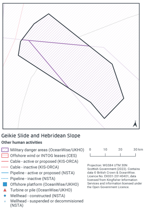
The map to display offshore region activities (Figure 7) was derived from OceanWise's Marine Themes Vector data (July 2023 version), Crown Estate Scotland leases (September 2023 version), Kingfisher Information Services Offshore Renewable Cable Awareness (KIS-ORCA, as of December 2023 held under licence) and North Sea Transition Authority (NSTA, as of December 2023, data held under Oil and Gas Authority open licence). The Marine Themes "Industrial" was filtered to show offshore region platforms, wellheads, piles, turbines, cables, and pipelines. Features marked as "not in use", "not present", "decommissioned", or "removed" were excluded. The "Administrative" data were filtered to only show military exercise areas which included danger areas.
4.3 Other offshore region activities occurring within Geikie Slide and Hebridean Slope NCMPA
The screening exercise using the Scottish Government's marine mapping tool only identified a military danger area overlapping with the site (Figure 4).
The Activities and Management section of the JNCC Site Information Centre for Geikie Slide and Hebridean Slope NCMPA, did not indicate any other activities occurring within the site.
Table 5 provides a list of the relevant activities, which were considered in combination with the fishing activities occurring within Geikie Slide and Hebridean Slope NCMPA.
Relevant activity |
Description |
|---|---|
Ministry of Defence practice area |
The MPA overlaps with a Ministry of Defence practice area, defined as a surface or firing danger area. This area is thought to be mostly used for sea surface activity such as vessel transiting and aerial use. |
4.4 Potential pressures exerted by fishing and other activities
Information on the MOD practice area within the site was available on the JNCC site information centre, which detailed that the activity was thought to be mostly used for sea surface activity such as vessel transiting and aerial use, and so is unlikely to interact with the protected features of the site.
4.5 Significance of effects/impacts to protected features
There were no other offshore region activities occurring within, or within 5 km, of the Geikie Slide and Hebridean Slope NCMPA potentially exerting pressures of concern that could overlap with those exerted by static demersal fishing (traps and anchored nets/lines), and to which the offshore deep-sea muds, offshore subtidal sands and gravels, and burrowed mud features is sensitive.
Accordingly, the in-combination effects of this MOD practice area and static demersal fishing (anchored nets/lines) at current activity levels are not considered to hinder the achievement of the conservation objectives such that the extent and distribution, structure and function and supporting processes are restored within Geikie Slide and Hebridean Slope NCMPA.
4.6 Part C Conclusion
Scottish Ministers conclude that the remaining fishing activities (demersal static gear: anchored nets/longlines) in-combination with other relevant activities will not hinder the achievement of the conservation objectives for Geikie Slide and Hebridean Slope NCMPA at current levels of activity.
Contact
Email: marine_biodiversity@gov.scot
There is a problem
Thanks for your feedback