Draft Fisheries Assessment – Hatton Bank SAC: Fisheries management measures within Scottish Offshore Marine Protected Areas (MPAs)
These assessments look at the fishing activity occurring within each offshore MPA and SAC and assess the potential impacts of this activity on the protected features within each site. This assessment is for Hatton Bank SAC.
1. Introduction
1.1 Scope of the Hatton Bank SAC assessment
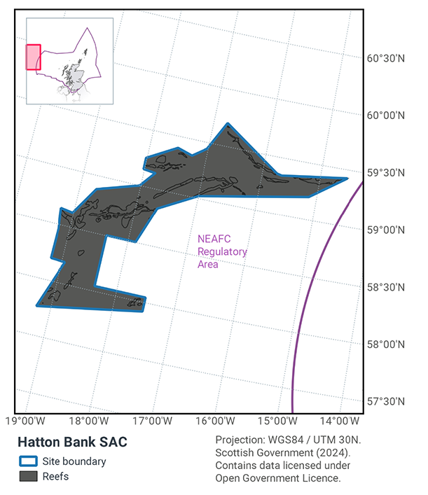
The geographic scope of this assessment covers the whole of Hatton Bank SAC (Figure 1) within the offshore region (12-200 nautical miles, nm). The purpose of this assessment is to determine whether the current levels of fishing activity occurring within the site are compatible with the conservation objectives of Hatton Bank SAC and identify options for management measures.
In this assessment, Scottish Ministers use the best available evidence to review the site characteristics and current fishing activity (Part A), both taken alone and in combination with other relevant activities (Part C), to determine if there is the potential for these activities to have a likely significant effect (LSE) on the designated feature of the site (Annex I Reef). Any fishing activities with the potential for LSE are considered further to assess whether they could result in an adverse effect on site integrity (Part B).
Where there is the potential for an adverse effect on site integrity, management measures are identified for the site by Scottish Ministers. These measures are considered in light of the conservation objectives, biological characteristics of protected features, current fishing activity and existing fisheries restrictions for Hatton Bank SAC. A final decision on which measures, if any, are to be adopted, will follow upon a statutory consultation exercise and will take into account all relevant statutory obligations incumbent upon Scottish Ministers.
A methodology document has been prepared to aid understanding of these assessments.
1.2 Site description
The Hatton Bank SAC (Figure 1) is a large volcanic bank located in the Atlantic North-West Approaches Regional Sea, and represents hard bedrock reef, stony and biogenic Lophelia pertusa and Madrepora oculata reef in deep circalittoral waters. The bedrock reef is of low to high topographic complexity.
The vast size and topographic complexity of the Hatton Bank SAC supports a wide diversity of biological communities, each associated with different seafloor structures and substratum types. The bedrock, cobbles and coral rubble are home to rich coral gardens and deep-sea sponge aggregations, and the distinct pinnacles and mounds support elaborate cold-water coral reefs.
The Conservation Objectives set out the desired quality of the protected features within each MPA. They are a set of specific objectives to be met in order for a site to maximise its contribution to ‘Favourable’ Conservation Status.
JNCC’s view on the overall condition of the site’s qualifying feature is that it is in unfavourable condition, (JNCC, 2020) and therefore needs to be restored to favourable condition.
The Conservation Objectives for the Annex I Reef at Hatton Bank SAC are:
Subject to natural change, maintain or restore the reef in/to favourable condition, such that:
- The extent and distribution of the qualifying habitat in the site;
- The structure and function of the qualifying habitat in the site; and
- The supporting processes on which the qualifying habitat relies.
are maintained or restored, thereby ensuring the integrity of the site and also making an appropriate contribution to favourable conservation status of the Annex 1 habitats (see the Hatton Bank Reef SAC Relevant Documentation & Conservation Advice 2018). Further information regarding the designation of Hatton Bank SAC is available in the Standard Data Form.
More information regarding the conservation objectives for the protected feature of Hatton Bank SAC is available within the site’s conservation advice package available on JNCC’s site information centre.
1.3 Activities assessed
The process followed to conduct this ‘Fisheries Assessment’ is in line with the process for a Habitats Regulation Appraisal, as required under Article 6(3) of Council Directive 92/43/EEC of 21 May 1992 on the conservation of natural habitats and of wild fauna and flora (the Habitats Directive) for sites within the offshore region under Regulation 28 of the Conservation of Offshore Marine Habitats and Species Regulations 2017.
In this context, fishing activity within the SAC is considered to be the plan or project, and the implications of the fishing activity in view of the conservation objectives for the SAC are being assessed through the fisheries screening stage (Part A), the fisheries assessment (Part B), and the in combination (cumulative effect) assessment (Part C).
Fisheries assessments use the best available evidence to fully consider potential impacts of commercial fishing activity, and in-combination (cumulative) effects with other plans and projects, against the conservation objectives for the site. If the assessment concludes that use of certain fishing gear types is not compatible with the conservation objectives of the site, management measures will be considered.
Commercial sea fishing activity has the potential to vary in nature and intensity over time. This assessment considers fishing activity based on activity levels and type between 2015-2019. This date range was considered to provide the best available data on current fishing activity levels for the assessment. Using a five year date range provides an average view of fishing activity within the site; latter years (2020 – 2021) were not considered representative of regular fishing activity due to the Covid pandemic. The selected date range (2015 – 2019) was used consistently across all assessments within the consultation package. Changes in fishing activity after this time period may be considered in future reviews of this assessment (see Section 5).
Contact
Email: marine_biodiversity@gov.scot
There is a problem
Thanks for your feedback