Draft Fisheries Assessment – Hatton Bank SAC: Fisheries management measures within Scottish Offshore Marine Protected Areas (MPAs)
These assessments look at the fishing activity occurring within each offshore MPA and SAC and assess the potential impacts of this activity on the protected features within each site. This assessment is for Hatton Bank SAC.
2. Part A Assessment – Fisheries Screening
2.1 Fisheries screening overview
Part A of this assessment meets the ‘likely significant effect (LSE)’ test under Article 6(3) of Council Directive 92/43/EEC of 21 May 1992 on the conservation of natural habitats and of wild fauna and flora (the Habitats Directive); for sites within the offshore region under Regulation 28 of the Conservation of Offshore Marine Habitats and Species Regulations 2017. The test for likely significant effect under Regulation 28(2)(b) of the Conservation of Offshore Marine Habitats and Species Regulations 2017 is not required for activities which are directly connected with or necessary to the management of the site. Fishing activities are not considered to be directly connected with or necessary to the management of the site unless otherwise indicated.
In line with the guidance within EU Commission guidance on the Assessment of plans and projects significantly affecting Natura 2000 sites; a methodological guidance on the provisions of Article 6 (3) and (4) of the Habitats Directive 92/43/EEC, this assessment considers an LSE as any effect that may reasonably be predicted as a consequence of a plan or project that would negatively and significantly affect the conservation objectives established for the designated habitats and species of the protected area. If any likely significant effect of a plan or project cannot be excluded beyond reasonable doubt, then a full appropriate assessment should be undertaken.
In Part A of this assessment the pressure-feature interactions were assessed to determine the potential for LSE and risk to the conservation objectives. This section looks at the pressures exerted by the fishing activity occurring in the site (within the assessment period) in relation to the sensitivities of the protected features. The potential for an LSE was identified where there was both a medium-high risk of a pressure arising from the fishing activity and if any of the features were considered sensitive to that pressure. These pressure-features interactions were then taken forward to the appropriate assessment stage (Part B) to determine whether the plan or project would have an adverse impact on site integrity.
For each activity assessed in Part A, there were two possible outcomes for each identified pressure-feature interaction:
1. The pressure-feature interactions were not included for Part B:
a. If the feature is not exposed to the pressure, and is not likely to be in the future; or
b. If the effect/impact of the pressure is not likely to be significant.
2. The pressure-feature interactions were included for assessment in Part B:
a. If the feature is exposed to the pressure, or is it likely to be in the future; and
b. If the potential scale or magnitude of any effect is likely to be significant; or
c. If it is not possible to determine whether the magnitude of any effect is likely to be significant.
Part B of the assessment aligns with the requirements for an Appropriate Assessment under the Conservation of Offshore Marine Habitats and Species Regulations 2017 (as amended) and considers the potential impact to site integrity by assessing the impact of fishing gears identified in Part A. This involves determining the potential level of interaction between the feature and the fishing activity, assessing the potential impact on the feature, and subsequently if fishing activities are liable to affect the conservation objectives of the site and thus the integrity of the site.
Consideration of exposure to and the effect of a pressure on a protected feature of the SAC includes the consideration of exposure to and the effect of that pressure on any ecological or geomorphological process on which the conservation of the protected feature is wholly or in part dependant.
2.2 Activities taking place within Hatton Bank SAC
To screen out fishing activities that were not taking place within the site or likely to take place in the future, vessel monitoring system (VMS) data within Hatton Bank SAC from 2015 – 2019 were analysed to identify the gear types being used in the site, their target species, and the aggregated gear method. The data showed that no forms of fishing activity currently occur within the Hatton Bank SAC.
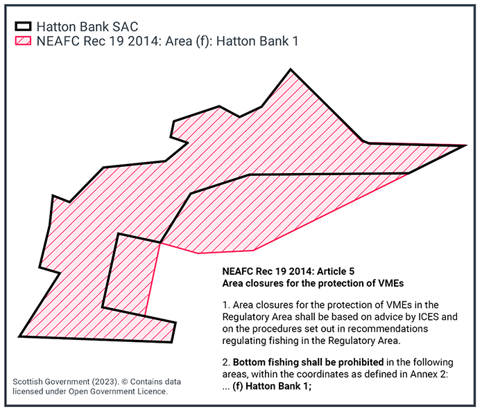
The absence of activity can be accounted for by the current fisheries restrictions in place across the site under North East Atlantic Fisheries Commission ‘NEAFC Rec 19 2014: on area management measures for the protection of vulnerable marine ecosystems in the NEAFC Regulatory Area, as amended’. The full extent of Hatton Bank SAC is closed to bottom fisheries, as shown in Figure 2.
Additionally, under Regulation (EU) 2016/2336 there is a prohibition on the use of bottom-set gillnets, entangling nets, and trammel nets at depths greater than 200 m for the protection of deep-water shark species.
2.3 Part A Conclusion
Considering the information on pressures and sensitivity above, and guidance within the EU Commission guidance on the Assessment of plans and projects significantly affecting Natura 2000 sites; a methodological guidance on the provisions of Article 6 (3) and (4) of the Habitats Directive 92/43/EEC in relation to European Sites, and the absence of any fisheries activity within Hatton Bank SAC, there are no fishing activities occurring which have the potential for LSE to the protected features. Therefore no further assessment through Part B (fisheries assessment) and Part-C (in-combination) is required.
Contact
Email: marine_biodiversity@gov.scot
There is a problem
Thanks for your feedback