Draft Fisheries Assessment – Hatton-Rockall Basin NCMPA: Fisheries management measures within Scottish Offshore Marine Protected Areas (MPAs)
These assessments look at the fishing activity occurring within each offshore MPA and SAC and assess the potential impacts of this activity on the protected features within each site. This assessment is for Hatton-Rockall Basin NCMPA.
1. Introduction
1.1 Scope of the Hatton-Rockall Basin NCMPA assessment
The geographic scope of this assessment covers the whole of Hatton-Rockall Basin NCMPA. The purpose of this assessment is to determine whether the current levels of fishing activity occurring within the site are compatible with the conservation objectives of the Hatton-Rockall Basin NCMPA.
In this assessment, Scottish Ministers use the best available evidence to review the site characteristics and current fishing activity (Part A), both taken alone and in combination with other relevant activities (Part C), to determine if the fishing activities are capable of affecting the protected features (deep-sea sponges and offshore deep-sea muds). Any fishing activities capable of affecting the protected features, either alone or in combination with other activities, are considered further to assess whether they would or might hinder achievement of the conservation objectives (Part B).
Where there is the potential for the achievement of the conservation objectives to be hindered, management measures are identified for the site by Scottish Ministers. These measures are considered in light of the conservation objectives, biological characteristics of the protected features, current fishing activity, other activity levels and existing fisheries restrictions for Hatton-Rockall Basin NCMPA. A final decision on which measures, if any, are to be adopted, will follow upon a statutory consultation exercise and will take into account all relevant statutory obligations incumbent upon Scottish Ministers.
A methodology document has been prepared to aid understanding of these assessments.
1.2 Site description
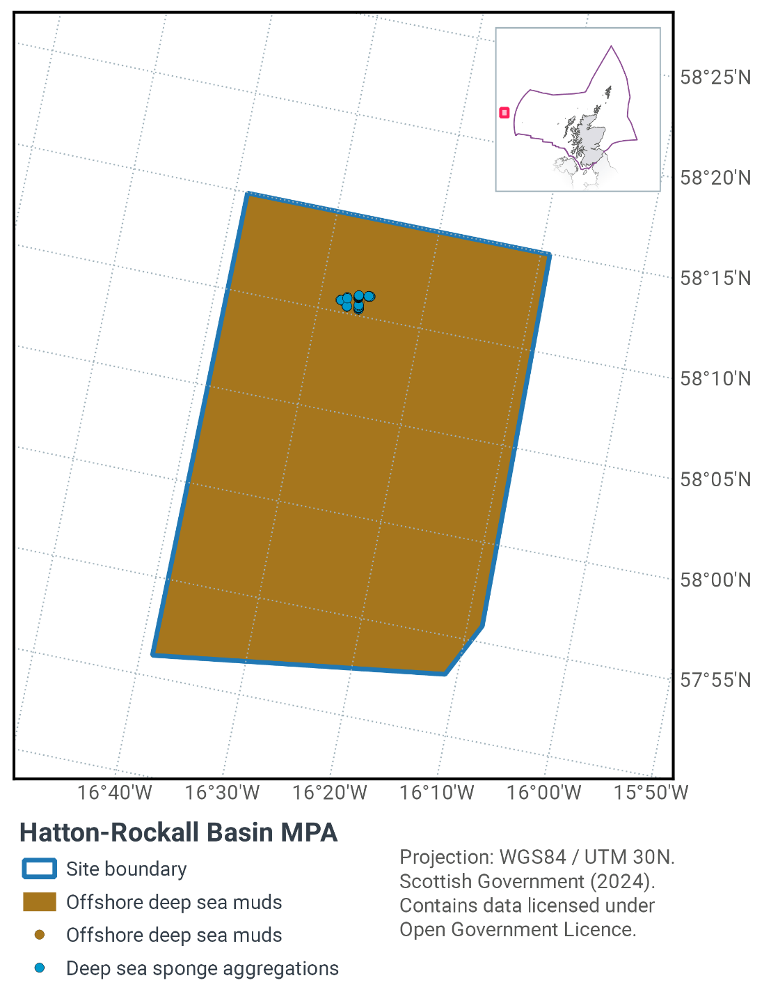
The Hatton-Rockall Basin NCMPA (Figure 1) is a site situated in a deep-water basin to the far west of Scotland covering 1,256 km2. The site is located between Hatton Bank to the west and Rockall Bank to the east and water depth at the site is over 1 km. This site has been protected to protect the habitats deep-sea sponge aggregations and offshore deep-sea muds; both are considered Priority Marine Features (PMFs) in Scotland’s seas.
Deep-sea sponge aggregations are on the OSPAR list of Threatened and/or Declining habitats & species and are considered to be Vulnerable Marine Ecosystems (VMEs). There are two different types of deep-sea sponge aggregations known to be present within the site; aggregations dominated by encrusting sponges and bird’s nest sponge (Pheronema carpenteri) fields. The bird’s nest sponge fields within the site are the only known examples to occur in UK waters. The encrusting sponge aggregation is typified by encrusting grey sponges living on boulders and mud substrata.
Both types of deep-sea sponge aggregations act as biodiversity hotspots, with a range of other species associated with them. For the bird’s nest sponge fields, these include ascidians, formaniferans, polychaetes and burrowing anemones, while the encrusting sponge aggregations include anemones, ascidians, crinoids and ophiuroids. The seabed in the area is littered with spicules, spiny remnants of dead sponges, that inhibit the establishment of burrowing animals but allow surface-dwelling species to thrive. For example, beds of brittlestars are present, which live on the surface of the seabed, filtering food from passing currents.
Offshore deep-sea mud habitat is predicted to be present throughout the Hatton-Rockall Basin NCMPA and is another of the site’s protected features. It is predicted that there are two different types of offshore deep-sea mud habitat in the NCMPA. The majority of it is believed to be "Atlantic mid bathyal mud and sandy mud", but this encompasses a patch of "Atlantic upper bathyal mud and sandy mud". There is little information on the level of biological diversity and composition of communities supported by the offshore deep-sea mud habitats in the MPA, however limited survey data support the presence of habitat that is dominated by different species of burrowing anemone as well as echinoderms such as starfish, sea cucumbers and sea urchins.
A series of unique geological features known as polygonal faults are also included for protection within the site. Polygonal faults are cracks in the seafloor, similar in appearance to those on a sun scorched desert. Usually, polygonal faulting occurs below the seafloor, but the faults in the Hatton-Rockall Basin are present on the surface of the seabed, making this a unique example of the feature. The hard edges of these cracks may facilitate the aggregations of deep-sea sponges by providing a suitable surface for settlement. Along with the polygonal faults, sediment drifts are also protected within the Hatton-Rockall Basin MPA, as it is a representative feature of the Hatton Bank (and adjacent sea floor) key geodiversity area.
JNCC’s view on the overall condition of the site’s qualifying features is uncertain. This is because there is limited information available on the human activities taking place within the Hatton-Rockall Basin MPA. In the absence of evidence, JNCC cannot provide a view on the condition of the protected features of the site. When more evidence becomes available, JNCC’s view on feature condition will be reviewed.
The Conservation Objective for the Hatton-Rockall Basin Nature Conservation Marine Protected Area is that the protected features listed below:
- so far as already in favourable condition, remain in such condition; and
- so far as not already in favourable condition, be brought into such condition, and remain in such condition.
With respect to deep-sea sponge aggregations and offshore deep-sea muds, this means that:
- extent is stable or increasing; and
- structures and functions, quality, and the composition of characteristic biological communities (which includes a reference to the diversity and abundance of marine fauna forming part of or inhabiting that habitat) are such as to ensure that it remains in a condition which is healthy and not deteriorating.
Any temporary deterioration in condition is to be disregarded if the features are sufficiently healthy and resilient to enable recovery from such deterioration. Any alteration to the features brought about entirely by natural processes is to be disregarded.
With respect to the sediment drifts and polygonal fault systems representative of the Hatton Bank (and adjacent seafloor) key geodiversity area, this means that:
- their extent, component elements and integrity are maintained;
- their structure and functioning are unimpaired; and
- their surfaces remain sufficiently unobscured for the purposes of determining whether the points listed above are satisfied.
Any obscuring of the features entirely by natural processes are to be disregarded. Any alteration to the features brought about entirely by natural processes are to be disregarded.
With regards to the scope of this assessment, JNCC considers that the large-scale feature and/or geomorphological features (sediment drifts and polygonal fault systems representative of the Hatton Bank (and adjacent seafloor) key geodiversity area) are unlikely to be impacted by fishing activities within the site. As such, these features are not considered further in this assessment.
Further information regarding the designation and conservation objectives for the protected features of Hatton-Rockall Basin NCMPA is available on the JNCC Hatton-Rockall Basin NCMPA webpage.
1.3 Activities assessed
The assessments consider the impacts of fisheries activities at each NCMPA in terms of the conservation objectives stated for the protected sites. This was deemed appropriate, in order to assist in identifying potential management measures.
In this context, the implications of fishing activity in view of the conservation objectives for the NCMPA are being assessed through the fisheries screening stage (Part A), the fisheries assessment (Part B), and the in combination (cumulative effect) assessment (Part C).
Fisheries Assessments use the best available evidence to fully consider potential impacts of commercial fishing activity, and in combination (cumulative) effects with other activities, against the conservation objectives of the site. If the assessment concludes that use of certain fishing gear would or might hinder achievement of the conservation objectives of the site, management measures will be considered.
Commercial sea fishing activity has the potential to vary in nature and intensity over time. This assessment considers fishing activity based on activity levels and type between 2015-2019. This date range was considered to provide the best available data on current fishing activity levels for the assessment. Using a five-year date range provides an average view of fishing activity within the site; latter years (2020 – 2021) were not considered representative of regular fishing activity due to the Covid pandemic. The selected date range (2015 – 2019) was used consistently across all assessments within the consultation package. Changes in fishing activity after this time period may be considered in future reviews of this assessment (see Section 4).
Contact
Email: marine_biodiversity@gov.scot
There is a problem
Thanks for your feedback