Draft Fisheries Assessment – North-East Faroe-Shetland Channel NCMPA: Fisheries management measures within Scottish Offshore Marine Protected Areas (MPAs)
These assessments look at the fishing activity occurring within each offshore MPA and SAC and assess the potential impacts of this activity on the protected features within each site. This assessment is for North-East Faroe-Shetland Channel NCMPA
1. Introduction
1.1 Scope of the North-East Faroe-Shetland Channel NCMPA assessment
The geographic scope of this assessment covers the whole of the North-East Faroe-Shetland Channel NCMPA (Figure 1). The purpose of this assessment is to determine whether the current levels of fishing activities would or might hinder the conservation objectives of North-East Faroe-Shetland Channel NCMPA and to identify options for management measures.
In this assessment, Scottish Ministers use the best available evidence to review the site characteristics and current fishing activity (Part A), both taken alone and in combination with other relevant activities (Part C), to determine if the fishing activities are capable of affecting the protected feature. Any fishing activities capable of affecting the protected features, either alone or in combination with other relevant activities, are considered further to assess whether they would or might hinder the achievement of the conservation objectives (Part B).
Where there is the potential for the achievement of the conservation objectives to be hindered, management measures are identified for the site by the Scottish Ministers. These measures are considered in light of the conservation objectives, biological characteristics, current fishing, other activity levels and existing fisheries restrictions for North-East Faroe-Shetland Channel NCMPA. A final decision on which measures, if any, are to be adopted, will follow upon a statutory consultation exercise and will take into account all relevant statutory obligations incumbent upon Scottish Ministers.
A methodology document has been prepared to aid understanding of these assessment.
1.2 Site description
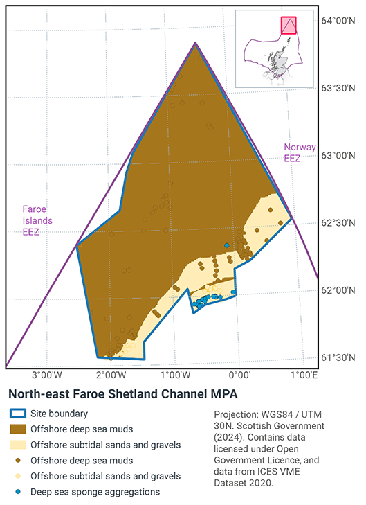
Located to the far north-east of Scottish waters this NCMPA covers over 23,000 km2 of the north-eastern reaches of the Faroe-Shetland Channel in Scottish waters. The habitats are strongly influenced by the significant range of environmental conditions present, from the upper continental slope to the depths of the channel, and include a dynamic mixing zone where warmer Atlantic waters flow over cooler Arctic waters.
The NCMPA has a depth range of 330 m – 2420 m extending from the edge of the continental slope down into cooler Arctic influenced waters. The continental slope plays an important role in funnelling ocean currents that bring valuable food and nutrients to the region, which in turn support a wide diversity of life. The channel is believed to be a corridor for migrating marine mammals, including fin whales (‘razorback’) and sperm whales.
The NCMPA includes several different features of geological importance, including the pilot whale diapirs. The diapirs are a series of deep-water mounds which measure 2 to 3 km across and rise to more than 70 m above the surrounding seafloor. The pilot whale diapirs are unusual in that they are the only known example found in UK waters that breach the seabed surface.
At depths of 400-600 m, the combination of seabed type and plentiful supply of nutrients are ideal for the establishment of deep-sea sponges. Up to 50 sponge species can be found within the sponge fields, many of which are different to those found in the surrounding areas. Below 800 m, the muddy seabed is home to those species that can tolerate the cooler Arctic-influenced waters, such as deep sea worms.
The type of deep-sea sponge aggregation which occurs within the North-East Faroe-Shetland Channel NCMPA is boreal ‘ostur’ (Howell et al., 2007; Henry & Roberts, 2014). Boreal ‘ostur’ sponge aggregations typically have a high abundance of species of giant sponge (Demospongia). Deeper than 800 m, the muddy seabed is home to species tolerant of the cold Arctic-influenced waters.
The boreal ostur variant of deep-sea sponge aggregations has only been recorded in the North Sea in Scottish waters. The deep-sea sponge aggregations conform to the OSPAR definition of this Threatened and / or Declining habitat (OSPAR, 2010b). They are also classed as a Vulnerable Marine Ecosystem (VME) according to FAO international guidelines (FAO, 2009). Therefore, this NCMPA makes a contribution to global commitments to protect VMEs.
Sedimentary features within the site are representative of offshore subtidal sands and gravels with sediment type and associated biological communities typically varying with depth. These habitats range from cobbles and boulders in shallower areas of the slope, to finer-grained sands and muds in deeper areas down the slope and in the channel itself (Bett, 2000).
The North-East Faroe-Shetland Channel NCMPA has been designated for the following protected features:
- Offshore deep-sea muds,
- Offshore subtidal sands and gravels,
- Deep-sea sponge aggregations,
- Continental slope
- Quaternary of Scotland - prograding wedge,
- Submarine Mass Movement - slide deposits,
- Marine Geomorphology of the Scottish Deep Ocean Seabed - contourite sand/silt; and Cenozoic Structures of the Atlantic Margin - mud diapirs
The conservation objectives for the North-East Faroe-Shetland Channel Nature Conservation Marine Protected Area (NCMPA) are that the protected features:
- so far as already in favourable condition, remain in such condition; and
- so far as not already in favourable condition, be brought into such condition, and remain in such condition.
With respect to the deep-sea sponge aggregations, offshore deep-sea muds and offshore subtidal sands and gravels, this means that:
- extent is stable or increasing; and
- structures and functions, quality, and the composition of characteristic biological communities (which includes a reference to the diversity and abundance of species forming part of or living within each habitat) are such as to ensure that they remain in a condition which is healthy and not deteriorating.
Any temporary deterioration in condition is to be disregarded if the habitats are sufficiently healthy and resilient to enable their recovery from such deterioration. Any alteration to the features brought about entirely by natural processes is to be disregarded.
With respect to the continental slope, this means that:
- its extent, distribution and structure is maintained;
- its function is maintained so as to ensure that it continues to support its characteristic biological communities (which includes a reference to the diversity of any species associated with the large-scale feature) and their use of the site for, but not restricted to, feeding, courtship, spawning, or use as nursery grounds; and
- the processes supporting it are maintained.
Any alteration brought about entirely by natural processes is to be disregarded.
With respect to the prograding wedge, slide deposits, contourite sand/silt and pilot whale diapirs representative of the West Shetland Margin Paleo-depositional system, north sea fan, Miller Slide and Pilot Whale Diapirs Key Geodiversity Areas this means that:
- their extent, component elements and integrity are maintained;
- their structure and functioning are unimpaired; and
- their surfaces remain sufficiently unobscured for the purposes of determining whether the above criteria are satisfied.
Any obscuring of the features entirely by natural processes is to be disregarded.
Any alteration to the features brought about entirely by natural processes is to be disregarded
For deep-sea sponge aggregations, the feature condition has been assessed by JNCC as being ‘Unfavourable’.
For continental slope, offshore deep-sea muds, offshore subtidal sands and gravels and a number of relict and active geodiversity features representative of the West Shetland Margin Paleo-Depositional System, Miller Slide, North Sea Fan and Pilot Whale Diapirs Key Geodiversity Areas, the feature condition has been assessed by JNCC as being ‘Favourable’.
More information regarding the designation of the North-East Faroe-Shetland Channel NCMPA is available in the Designation Order.
More information regarding the conservation objectives and feature condition for the protected features of North-East Faroe-Shetland Channel NCMPA is available within the site’s Conservation Advice package.
With regards to the scope of this assessment, JNCC considers that the large-scale features and the geological / geomorphological features are unlikely to be impacted by fishing activities within the site. As such, these features (continental slope and the prograding wedge, slide deposits, contourite sand/silt and Pilot whale diapirs representative of the West Shetland Margin Paleo-Depositional System, north sea fan, Miller Slide and pilot whale diapirs key geodiversity areas) are not considered further in this assessment.
1.3 Activities assessed
The assessments consider the impacts of fisheries activities at each NCMPA in terms of the conservation objectives stated for the protected sites. This was deemed appropriate/necessary to do, in order to assist in identifying potential management measures.
In this context, the implications of the fishing activity in view of the conservation objectives for the NCMPA are being assessed through the fisheries screening stage (Part A), the fisheries assessment (Part B), and the in combination (cumulative effect) assessment (Part C).
Fisheries assessments use the best available evidence to fully consider potential impacts of commercial fishing activity, and in-combination (cumulative) effects with other activities, against the conservation objectives for the site. If the assessment concludes that use of certain fishing gear types would or might hinder the achievement of the conservation objectives of the site, management measures will be considered.
Commercial sea fishing activity has the potential to vary in nature and intensity over time. This assessment considers fishing activity based on activity levels and type between 2015-2019. This date range was considered to provide the best available data on current fishing activity levels for the assessment. Using a five year date range provides an average view of fishing activity within the site; latter years (2020 – 2021) were not considered representative of regular fishing activity due to the Covid pandemic. The selected date range (2015 – 2019) was used consistently across all assessments within the consultation package. Changes in fishing activity after this time period may be considered in future reviews of this assessment (see Section 6).
Contact
Email: marine_biodiversity@gov.scot
There is a problem
Thanks for your feedback