Draft Fisheries Assessment – North-East Faroe-Shetland Channel NCMPA: Fisheries management measures within Scottish Offshore Marine Protected Areas (MPAs)
These assessments look at the fishing activity occurring within each offshore MPA and SAC and assess the potential impacts of this activity on the protected features within each site. This assessment is for North-East Faroe-Shetland Channel NCMPA
3. Part B Assessment – Fisheries Assessment
3.1 Fisheries assessment overview
Part B of this assessment considers if there would be a risk of the fishing activities identified in Part A, at the levels identified in the relevant date range, hindering the achievement of the conservation objectives for the MPA. This is in order to consider whether, and if so which, management measures might be appropriate for the MPA, taking into account all relevant statutory obligations incumbent upon the Scottish Ministers.
The fishing activities and pressures identified in Part A which have been included for assessment in Part B, are demersal trawls. The pressures associated with these fishing activities that have been included in Part B are;
- abrasion/disturbance of the substrate on the surface of the seabed;
- penetration and/or disturbance of the substrate below the surface of the seabed, including abrasion;
- removal of non-target species; and
- smothering and siltation rate changes (light).
3.2 Fishing Activity Descriptions
3.2.1 Existing management within North-East Faroe-Shetland Channel NCMPA
In compliance with Part 5, Chapter 7 of The Common Fisheries Policy and Aquaculture (Amendment etc.) (EU Exit) Statutory Instrument (S.I.) 2019 No. 753, there is a ban on the use of all bottom-contacting mobile gear below 800 m depth across all UK waters. This applies across the area of The North-East Faroe-Shetland Channel NCMPA where the depth falls below 800 metres.
Under The Common Fisheries Policy and Animals (Amendment etc.) (EU Exit) Regulations 2019 S.I. 2019, No. 1312 (amending S.I 2019, No. 753) there is a prohibition on the use of bottom-set gillnets, entangling nets, and trammel nets at depths greater than 200 metres for the protection of deepwater shark species.
Part 5 Chapter 7 of S.I. 2019, No. 753 also implements restrictions on fishing between 400 metres and 800 metres where Vulnerable Marine Ecosystems (VMEs) are present, or are likely to occur. These rules aim to minimise the impact of fishing activities on VMEs.
3.2.2 Fishing activity within the NCMPA
The North-East Faroe-Shetland Channel NCMPA overlaps ICES rectangles 56E9, 56E8, 55E8, 55E9, 55FO, 54E7, 54E8, 54E9, 54F0, 53E7, 53E8, 53E9,53FO, 52E7, 52E8 and 52E9 in ICES Division 2a and 4a.
The main gear types for UK vessels are midwater trawls and demersal trawls, predominantly targeting pelagic and demersal fish species.
VMS-based estimates and ICES rectangle landings statistics indicate that over-12 m demersal and midwater trawls are the predominant UK vessels that operated within the site over the period 2015-2019. For the over-12 m vessels, based on VMS data from 2015-2019, demersal trawls operate predominantly in the southern area of the site.
In addition to UK activity, vessels from Norway (13 vessels), may also operate in the site based on VMS data from 2015-2020. However, it is not clear what gear types these vessels operate, nor whether they were actively fishing at the time.
3.2.3 Demersal trawls
Only bottom otter trawls operated within the North-East Faroe-Shetland Channel NCMPA between 2015 and 2019 (Table 1).
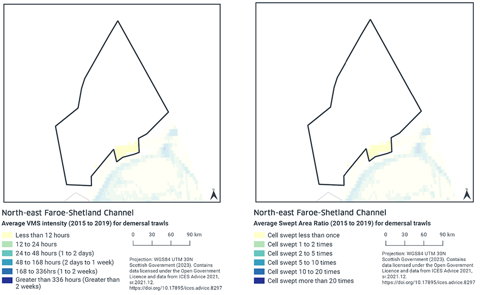
Based on the VMS, the highest intensity of demersal trawl activity within North-East Faroe-Shetland Channel NCMPA occurs at the southern edge of the site, with average annual activity peaking at under 12 hours per year per grid cell between 2015-2019 (Figure 2). The remainder of the site had no demersal fishing activity over this same period.
Swept-Area Ratio (SAR) information averaged over the same time period shows similar patterns of fishing intensity as the VMS data with the southern edge of the site showing the highest SAR values, being swept less than once per year between 2015-2019 (Figure 2). The SAR values reduce away from this area, with the majority of the site not being swept.
3.2.4 Fishing activity summary
Fishing activities using demersal trawls were shown to occur within the North-East Faroe-Shetland Channel NCMPA. Demersal trawling activity is concentrated in the southern area of the site. The majority of the site is subject to bottom contacting gear restrictions.
3.3 Fishing activity effects overview
The following sections explore the impacts associated with fishing activity (demersal trawls) within the North-East Faroe-Shetland Channel NCMPA that were considered capable of impacting the protected features. The pressures considered in the following section are:
- Abrasion/disturbance of the substrate on the surface of the seabed;
- Penetration and/or disturbance of the substrate below the surface of the seabed, including abrasion;
- Removal of non-target species and
- Smothering and siltation rate changes (light).
Given the similarity between ‘abrasion/disturbance of the substrate on the surface of the seabed’ and ‘penetration and/or disturbance of the substrate below the surface of the seabed’, these two pressures are considered together in the text below.
All pressures considered capable of impacting are discussed under the aggregated fishing gear types of ‘mobile demersal gears’.
3.3.1 Impacts associated with mobile demersal gear on North-East Faroe-Shetland Channel NCMPA features
Studies on deep-sea sponge aggregations have found that trawling damages, displaces and removes sponges through direct physical impact as well as from disturbed sediment resettling and causing smothering beyond the path of the trawl itself (OSPAR, 2010; ICES, 2007; ICES, 2010; Puig et al., 2012). Deep-sea sponges have some capacity for recovery from mild damage, but significant disturbance, damage or smothering may result in sponges being unlikely to survive (ICES, 2007)(ICES, 2010).
In general, the impact of demersal mobile gear on offshore subtidal sands and gravels is relatively well understood. In high energy locations (i.e. of wave and/or tide exposed) the associated fauna tend to be well adapted to disturbance and as a result are more tolerant of fishing-related disturbance (Dernie, Kaiser, & Warwick, 2003) (Hiddink, et al., 2006). In lower energy locations, such as muddy sands and sand in deep water, sediments tend to be more stable and their associated fauna less tolerant of disturbance (Hiddink, et al., 2006)(Kaiser, et al., 2006).
Stable gravels often support a ‘turf’ of fragile species which are easily damaged by trawling and recover slowly (Collie, Hall, Kaiser, & Poiner , 2000 and Foden, Rogers, & Jones, 2010). Trawling and dredging tends to cause increased mortality of fragile and long-lived species and favour opportunistic, disturbance-tolerant species (Eleftheriou & Robertson, 1992 and Bergmann & Van Santbrink, 2000). Some particularly sensitive species may disappear entirely (Bergmann & Van Santbrink, 2000). There is a possibility that exposure to demersal mobile gears may result in some degree of modification relative to the un-impacted state (Bergmann & Van Santbrink, 2000 and Kaiser, et al., 2006).
Studies have shown that areas of offshore deep-sea mud habitats subject to mobile fishing activity support a modified biological community with lower diversity, reduction or loss of long-lived filter-feeding species and increased abundance of opportunistic scavengers (Tuck et al., 1998; Ball, Fox, & Munday, 2000). This effect was greatest in the more heavily fished offshore areas suggesting that impact is related to the intensity of fishing (Ball, Fox, & Munday, 2000). Furthermore, modelling studies suggest that the greatest impact is produced by the first pass of a trawl (Hiddink, et al., 2006). As with the sands and gravel feature, there is a possibility that exposure to demersal mobile gears may result in some degree of modification.
Through physical impacts from gear interacting with the seabed, mobile demersal gear used at current levels of activity carry a risk of hindering the conservation objectives for the offshore subtidal sands and gravels, offshore deep-sea muds feature and deep-sea sponge aggregations. Accordingly, Scottish Ministers conclude that demersal trawls at current activity levels would or might hinder the achievement of the conservation objectives for the North-East Faroe-Shetland Channel NCMPA.
3.4 Part B Conclusion
The assessment of fishing pressures on offshore subtidal sands and gravels, offshore deep-sea muds feature, and deep-sea sponge aggregations features of North-East Faroe-Shetland Channel NCMPA has indicated that demersal trawling activities would or might hinder the achievement of the conservation objectives for the site. As such Scottish Ministers conclude that management measures are required to restrict demersal trawling within North-East Faroe-Shetland Channel NCMPA. Section 6 contains further details on potential measures.
Scottish Minister concludes that the remaining fisheries activities, when considered in isolation at current levels, will not hinder the achievement of the conservation objectives of North-East Faroe-Shetland Channel NCMPA at current levels of activity.
Contact
Email: marine_biodiversity@gov.scot
There is a problem
Thanks for your feedback