Draft Fisheries Assessment – North-West Orkney NCMPA: Fisheries management measures within Scottish Offshore Marine Protected Areas (MPAs)
These assessments look at the fishing activity occurring within each offshore MPA and SAC and assess the potential impacts of this activity on the protected features within each site. This assessment is for North-West Orkney NCMPA.
1. Introduction
1.1 Scope of the North-west Orkney NCMPA assessment
The geographic scope of this assessment covers the whole of North-west Orkney NCMPA. The purpose of this assessment is to determine whether the current levels of fishing activities would or might hinder the conservation objectives of North-west Orkney NCMPA and to identify options for management measures.
In this assessment, Scottish Ministers use the best available evidence to review the site characteristics and current fishing activity (Part A), both taken alone and in combination with other relevant activities (Part C) to determine if the fishing activities are capable of impacting the protected features (sandeel). Any fishing activities capable of impacting the protected features, either alone or in combination with other relevant activities, are considered further to assess whether they would or might hinder the achievement of the conservation objectives (Part B).
Where there is the potential for the achievement of the conservation objectives to be hindered, management measures are identified for the site by Scottish Ministers. These measures are considered in light of the conservation objectives, biological characteristics, current fishing and other activity levels and existing fisheries restrictions for North-west Orkney NCMPA. A final decision on which measures, if any, are to be adopted, will follow upon a statutory consultation exercise and will take into account all relevant statutory obligations incumbent upon Scottish Ministers.
A methodology document has been prepared to aid understanding of these assessments.
1.2 Site description
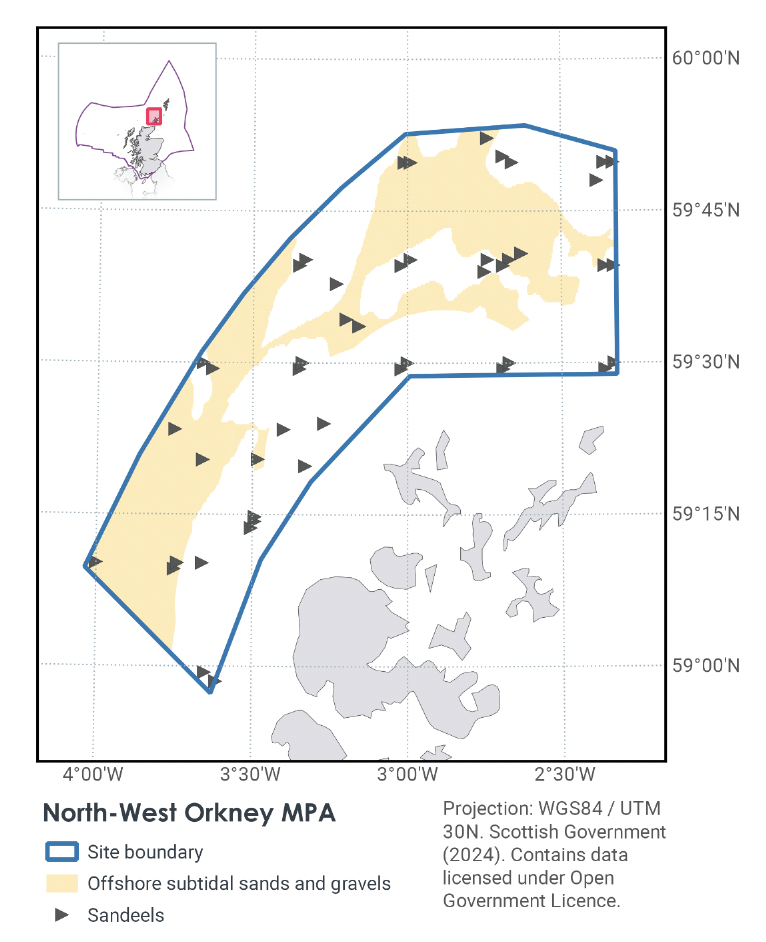
The North-west Orkney NCMPA (Figure 1) is a shallow area lying to the north and west of the Orkney Isles on the Scottish continental shelf. The area is considered important as an export ground for sandeel – a type of burrowing fish that forms a critical component of many North Sea food webs.
The area is characterised by a mixed ground type (areas of rough substrate within the areas of sediment) which make it suitable for sandeel colonisation. This may also account for the patchiness of the larval distribution. The NCMPA plays an important role in supporting wider populations of sandeel in Scottish waters. Specifically, newly hatched sandeel larvae from this region are exported by currents to sandeel grounds around Shetland and the Moray Firth. This is supported by a time series of data on larval abundance that date back to the 1950s as, illustrating the continued importance of this area as an export ground for sandeel.
The NCMPA also includes protection for geomorphological features representative of the Fair Isle Strait Marine Process Bedforms Key Geodiversity Area. These shelf tidal bedform features such as the sediment wave fields, sand wave fields and sandbanks, are active and are maintained under a specific range of tidal current conditions. It is thought that the study of these features can help improve our understanding of the relationships between currents and seabed sediments.
JNCC’s view on the overall condition of the site’s qualifying features is that the features are in favourable condition.
The Conservation Objectives for the North-west Orkney NCMPA is that the protected features listed below are:
- so far as already in favourable condition, remain in such condition; and
- so far as not already in favourable condition, be brought into such condition, and remain in such condition.
In the designation order, “favourable condition”, with respect to a mobile species of marine fauna, means that:
- the species is conserved or, where relevant, recovered to include the continued access by the species to resources provided by the NCMPA for, but not restricted to, feeding, courtship, spawning or use as nursery grounds;
- the extent and distribution of any supporting features upon which the species is dependent is conserved or, where relevant, recovered; and
- the structure and function of any supporting features, including any associated processes supporting the species within the MPA, is such as to ensure that the protected feature is in a condition which is healthy and not deteriorating.
With respect to the sandeel, this means that the quality and quantity of its habitat and the composition of its population are such that they ensure that the population is maintained in numbers which enable it to thrive.
Any temporary reduction of numbers is to be disregarded if the population of sandeel is thriving and sufficiently resilient to enable its recovery from such reduction. Any alteration to that feature brought about entirely by natural processes is to be disregarded.
With respect to the sand banks, sand wave fields and sediment wave fields representative of the Fair Isle Straight Marine Process Bedforms Key Geodiversity Area conservation objectives, this means that:
- their extent, component elements and integrity are maintained;
- their structure and functioning are unimpaired; and
- their surface remains sufficiently unobscured for the purposes of determining whether the above points are satisfied.
Any obscuring of that feature entirely by natural processes is to be disregarded. Any alteration to that feature brought about entirely by natural processes is to be disregarded.
Further information regarding the designation and conservation objectives is available within the site’s conservation advice package available on JNCC’s site information centre.
1.3 Activities assessed
The assessments consider the impacts of fisheries activities at each NCMPA in terms of the conservation objectives stated for the designated sites. This was deemed appropriate, in order to assist in identifying potential management measures.
In this context, the implications of the fishing activity in view of the conservation objectives for the NCMPA are being assessed through the fisheries screening stage (Part A), the fisheries assessment (Part B), and the in combination (cumulative effect) assessment (Part C).
Fisheries assessments use the best available evidence to fully consider potential impacts of commercial fishing activity, and in-combination (cumulative) effects with other activities, against the conservation objectives for the site. If the assessment concludes that use of certain fishing gear types would or might hinder the achievement of the conservation objectives of the site, management measures will be considered.
Commercial sea fishing activity has the potential to vary in nature and intensity over time. This assessment considers fishing activity based on activity levels and type between 2015-2019. This date range was considered to provide the best available data on current fishing activity levels for the assessment. Using a five-year date range provides an average view of fishing activity within the site; latter years (2020 – 2021) were not considered representative of regular fishing activity due to the Covid pandemic. The selected date range (2015 – 2019) was used consistently across all assessments within the consultation package. Changes in fishing activity after this time period may be considered in future reviews of this assessment (see Section 6).
Contact
Email: marine_biodiversity@gov.scot
There is a problem
Thanks for your feedback