Draft Fisheries Assessment – North-West Orkney NCMPA: Fisheries management measures within Scottish Offshore Marine Protected Areas (MPAs)
These assessments look at the fishing activity occurring within each offshore MPA and SAC and assess the potential impacts of this activity on the protected features within each site. This assessment is for North-West Orkney NCMPA.
4. Part C Assessment – In Combination Assessment
Part C of this assessment considers the cumulative impacts, which may occur over space and time, in relation activities occurring within the MPA. Activities assessed in this section include the following:
- Fishing activity/pressure combinations which were excluded in Part A of this assessment as not being capable of impacting the feature;
- Fishing interactions assessed in Part B but that would not hinder the conservation objectives for the site; and
- Activities occurring within North-west Orkney NCMPA that are not related to fishing.
Fishing activities including boat dredges, demersal seines, demersal trawls, anchored nets/lines, creels and traps and pelagic fishing were not considered in Part B as requiring management and so they will be assessed in combination with other activities occurring at the site in this Part C.
4.1 In-combination assessment overview
4.1.1 Other offshore region activities screening
To determine activities not related to fishing activities to be included within this part of the assessment, a distance of 5 km was selected as suitable to capture any potential source receptor pathways that could impact the site in combination with effects of the fishing activities assessed. A 5 km buffer was therefore applied to the site boundary to identify relevant activities.
Activities not related to fishing activities were identified using the Scottish Government’s marine mapping tool. The JNCC Conservation Advice package, and other resources on the JNCC Site Information Centre for North-west Orkney NCMPA, were also screened for activities occurring in the site that should be considered in the in-combination assessment.
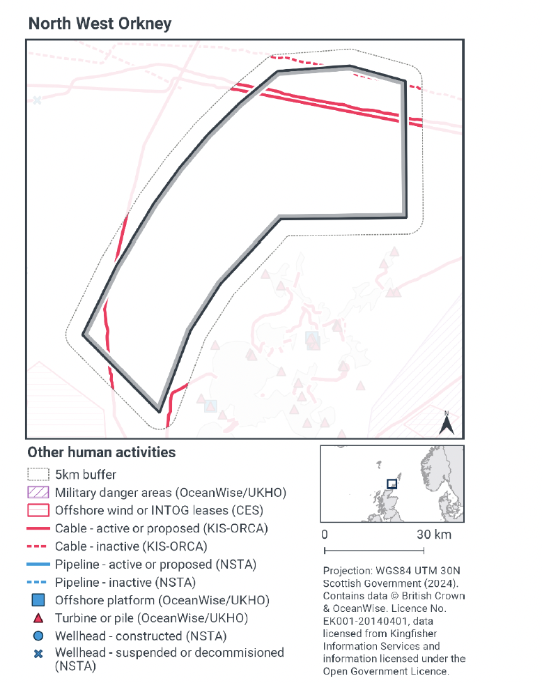
The map to display offshore region activities (see Figure 7) was derived from OceanWise’s Marine Themes Vector data (July 2023 version), Crown Estate Scotland leases (September 2023 version), Kingfisher Information Services Offshore Renewable Cable Awareness (KIS-ORCA, as of December 2023 held under licence) and North Sea Transition Authority (NSTA, as of December 2023, data held under Oil and Gas Authority open licence). The Marine Themes “Industrial” was filtered to show offshore region platforms, wellheads, piles, turbines, cables, and pipelines. Features marked as “not in use”, “not present”, “decommissioned”, or “removed” were excluded. The “Administrative” data were filtered to only show military exercise areas which included danger areas.
4.1.2 Other offshore region activities occurring within North-west Orkney NCMPA
The screening exercise using the Scottish Government’s marine mapping tool identified four subsea telecommunication cables running through the site (Figure 7). The northern most of which was identified as decommissioned.
The Activities and Management section the JNCC Site Information Centre for North-west Orkney NCMPA, indicated that there are no other activities currently occurring within the site. However, theNCMPAoverlaps with the renewables areas WN2 identified in the Draft Sectoral Marine Plans meaning the site may be subject to development, and relevant associated assessments in the future.
4.1.3 Potential pressures exerted by fishing and other activities
The active telecommunications cables in the north of the site are in-situ and not exerting the pressures that would be associated with laying, burial and protection or decommissioning. The only pressures associated with the operation and maintenance telecommunications cables (JNCC PAD) that overlap with the pressures exerted by demersal static (anchored nets/lines and traps and creels) fishing (JNCC PAD) on the sandeel and sandbanks, sand wave fields and sediment sensitive (FeAST) features which are considered sensitive are;
- abrasion/disturbance of the substrate on the surface of the seabed and
- penetration and/or disturbance of the substrate below the surface of the seabed, including abrasion
According to JNCC PAD, if either of the active telecommunications cables crossing the site need to be reburied or uncovered for repair, abrasion and physical disturbance will occur. However, the frequency of this activity will be very low.
All other pressures associated with both the operation and maintenance of telecommunications cables and static demersal fishing (traps and anchored nets/lines), to which the sandeel and sandbanks, sand wave fields and sediment features are sensitive, had low risk profiles for relevant activities.
4.1.4 Significance of effects/impact to protected features
The pressures identified in Section 4.4 occur where the cable needs to be reburied or uncovered for repair, abrasion and physical disturbance will occur. The frequency of the activity will be very low.
In relation to pelagic fishing activity, there is no overlap between the identified pressures exerted by the active telecommunication cable and fishing activity, and therefore no in-combination effect is identified.
Both pressures identified for telecommunication cables overlap with the pressures exerted by demersal mobile gears which occur within the site. For demersal static gears, the only overlapping pressure was penetration and/or disturbance of the substrate below the surface of the seabed. All these pressure-feature interactions for the fishing gears were not considered likely to impact the protected features of the site in Part B. When taken into account with the pressures exerted by operation and maintenance of telecommunication cables, as the frequency of the activity is considered to be very low, no further management is considered.
Subsequently, the assessment of the in combination effects of the pressures from the operation and maintenance of telecommunications cables and the pressures from demersal mobile, static and pelagic fishing within the site at current level of activities on sandeel and sediment wave fields and sand wave features of North-west Orkney NCMPA has concluded that they will not hinder the achievement of the conservation objectives.
4.2 Part C conclusion
Scottish Ministers conclude that the remaining fishing activities (pelagic, demersal mobile and demersal static fishing) in-combination with other relevant activities will not hinder the achievement of the conservation objectives for North-west Orkney NCMPA at current levels of activity.
Contact
Email: marine_biodiversity@gov.scot
There is a problem
Thanks for your feedback