Draft Fisheries Assessment – North West Rockall Bank SAC: Fisheries management measures within Scottish Offshore Marine Protected Areas (MPAs)
These assessments look at the fishing activity occurring within each offshore MPA and SAC and assess the potential impacts of this activity on the protected features within each site. This assessment is for North West Rockall Bank SAC.
1. Introduction
1.1 Scope of the North West Rockall Bank SAC assessment
The geographic scope of this assessment covers the whole of the North West Rockall Bank SAC. The purpose of this assessment is to determine whether the current levels of fishing activity occurring within the site are compatible with the conservation objectives of the North West Rockall Bank SAC and to identify options for management measures.
In this assessment, Scottish Ministers use the best available evidence to review the site characteristics and current fishing activity (Part A), both taken alone and in combination with other relevant activities (Part C), to determine if there is the potential for these activities to have a likely significant effect (LSE) on the protected feature of the site (Reefs). Any fishing activities with the potential for LSE, either alone or in combination with other relevant activities, are considered further to assess whether they could result in an adverse effect on site integrity (Part B).
Where there is the potential for an adverse effect on stie integrity, fisheries management measures are identified for the site by Scottish Ministers. These measures are considered in light of the conservation objectives, biological characteristics, current fishing activity and existing fisheries restrictions for North West Rockall Bank SAC. A final decision on which measures, if any, are to be adopted, will follow upon a statutory consultation exercise and will take into account all relevant statutory obligations incumbent upon Scottish Ministers.
A methodology document has been prepared to aid understanding of these assessments.
1.2 Site description
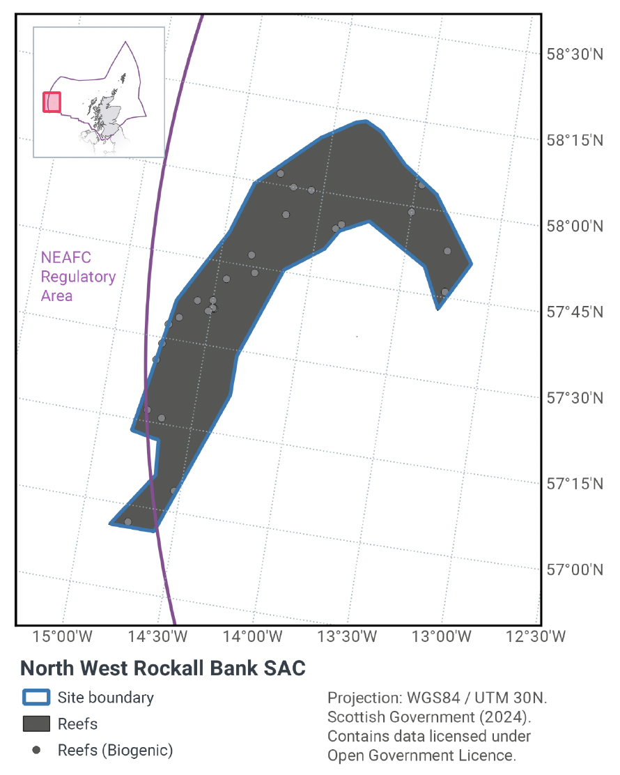
Rockall Bank is an offshore bank situated in the North-East Atlantic, approximately 400 km west of the Outer Hebrides, as shown in Figure 1. It is oriented northeast to southwest, and is approximately 450 km in length and 200 km wide. Depth ranges from over 1,000 m at the base of the Rockall Bank, to 200 m across much of the top. The centre of the bank breaks the surface forming a rocky island outcrop around 25 m wide and 20 m high. The protected features of the site are Annex I Reef; biogenic and stony. On account of their sheer size, oceanic banks such as Rockall cause the deviation of ocean currents along their flanks. This facilitates the colonization of habitat-forming corals which depend on a consistent supply of current-transported organic matter and zooplankton (Freiwald et al., 2004). Rockall Bank is potentially one of the most extensive sites for biogenic reef formed by cold water coral species in UK waters.
The northwest area of the Rockall Bank is covered in a layer of fine sediment, gravel, cobbles and boulders of glacial origin, some of which was shaped into characteristic ‘plough mark’ formations by icebergs during the last ice age. These iceberg plough marks are a variant of Annex I stony reef and consist of lines of cobbles and boulders with a sediment-filled furrow between (Howell et al 2009). The wide variety of associated biological communities are dependent on this mixed sediment and stony substratum, rather than on the underlying bedrock.
Within areas of stony reef are sizeable patches of Annex I biogenic reef comprising the cold-water coral Lophelia pertusa and associated species, including erect sponges and the pencil urchin Cidaris cidaris. Stands of Madrepora oculata, another cold-water coral species, are also present (Howell et al., 2009). Coral rubble surrounds the living reefs in many places and supports fauna such as the squat lobster Munida rugosa, the holothurian Parastichopus tremulus, the pencil urchin Cidaris cidaris, brittle stars and encrusting yellow sponges. Evidence from the 1970s suggests that areas of Lophelia pertusa reef up to 30 m in diameter existed on the Northwest Rockall Bank SAC (Wilson, 1979a and 1979b; Davies and Roberts, 2006), though more recent surveys (albeit at different locations in this region) have recorded reefs smaller in size (Howell et al., 2009). The site makes a valuable contribution to the UK Network.
The area of the SAC is 4,365 km2 with reef habitat distributed throughout the site. Although point records in the form of survey ground truth data confirm the presence of Annex I stony and biogenic reef subtypes, high resolution data is not available across the site to allow for reef extents to be mapped at a fine scale. Given the records available, and what is known about the location and conditions associated with the site, it is likely that Annex I reef is distributed across the SAC, although there may be areas where it is patchy in distribution. Therefore, the estimated extent of reef habitat within the SAC is the same as the area of the site (4,365 km2).
The Conservation Objectives for the Annex I Reefs at North West Rockall Bank SAC are:
For the feature to be in favourable condition, thus ensuring site integrity in the long-term and contribution to Favourable Conservation Status of Annex I Reefs. This contribution would be achieved by maintaining or restoring, subject to natural change:
- The extent and distribution of the qualifying habitat in the site;
- The structure and function of the qualifying habitat in the site; and
- The supporting processes on which the qualifying habitat relies.
JNCC’s view on the overall condition of the site’s qualifying feature is that it is in unfavourable condition and therefore needs to be restored to favourable condition.
More information regarding the Designation Orders for the North West Rockall Bank SAC is available in the Standard Data Form.
More information regarding the conservation objectives for the protected feature of North West Rockall Bank SAC is available within the site’s conservation advice package available on JNCC’s site information centre.
1.3 Activities assessed
The process followed to conduct this ‘Fisheries Assessment’ is in line with the process for a Habitats Regulation Appraisal, as required under Article 6(3) of Council Directive 92/43/EEC of 21 May 1992 on the conservation of natural habitats and of wild fauna and flora (the Habitats Directive); for sites within the offshore region under Regulation 28 of the Conservation of Offshore Marine Habitats and Species Regulations 2017.
In this context, fishing activity within the SAC is considered to be the plan or project, and the implications of fishing activity in view of the conservation objectives for the SAC are being assessed through the fisheries screening stage (Part A), the fisheries assessment (Part B), and the in combination (cumulative effect) assessment (Part C).
Fisheries assessments use the best available evidence to consider potential impacts of commercial fishing activity, and in-combination (cumulative) effects with other plans and projects, against the conservation objectives for the site. If the assessment concludes that use of certain fishing gear types is not compatible with the conservation objectives of the site, management measures will be considered.
Commercial sea fishing activity has the potential to vary in nature and intensity over time. This assessment considers fishing activity based on activity levels and type between 2015-2019. This date range was considered to provide the best available data on current fishing activity levels for the assessment. Using a five year date range provides an average view of fishing activity within the site; latter years (2020 – 2021) were not considered representative of regular fishing activity due to the Covid pandemic. The selected date range (2015 – 2019) was used consistently across all assessments within the consultation package. Changes in fishing activity after this time period may be considered in future reviews of this assessment (see Section 6).
Contact
Email: marine_biodiversity@gov.scot
There is a problem
Thanks for your feedback