Draft Fisheries Assessment – Norwegian Boundary Sediment Plain NCMPA: Fisheries management measures within Scottish Offshore Marine Protected Areas (MPAs)
These assessments look at the fishing activity occurring within each offshore MPA and SAC and assess the potential impacts of this activity on the protected features within each site. This assessment is for Norwegian Boundary Sediment Plain NCMPA.
1. Introduction
1.1 Scope of the Norwegian Boundary Sediment Plain NCMPA assessment
The geographic scope of this assessment covers the whole of Norwegian Boundary Sediment Plain NCMPA. The purpose of this assessment is to determine whether the current levels of fishing activity occurring within the site would or might hinder the conservation objectives of the Norwegian Boundary Sediment Plain NCMPA and to identify options for management measures.
In this assessment, Scottish Ministers use the best available evidence to review the site characteristics and current fishing activity (Part A), both taken alone and in combination with other relevant activities (Part C) to determine if the fishing activities are capable of affecting the protected features (Ocean Quahog aggregations and Offshore subtidal sands and gravels). Any fishing activities capable of affecting the protected features either alone or in combination with other relevant activities are considered further to assess whether they would or might hinder the achievement of the conservation objectives (Part B).
Where there is the potential for the achievement of the conservation objectives to be hindered, fisheries management measures are identified for the site by the Scottish Ministers. These measures are considered in light of the conservation objectives, biological characteristics, current fishing and other activity levels and existing fisheries restrictions for Norwegian Boundary Sediment Plain NCMPA. A final decision on which measures, if any, are to be adopted, will follow upon a statutory consultation exercise and will take into account all relevant statutory obligations incumbent upon Scottish Ministers.
A methodology document has been prepared to aid understanding of these assessments.
1.2 Site description
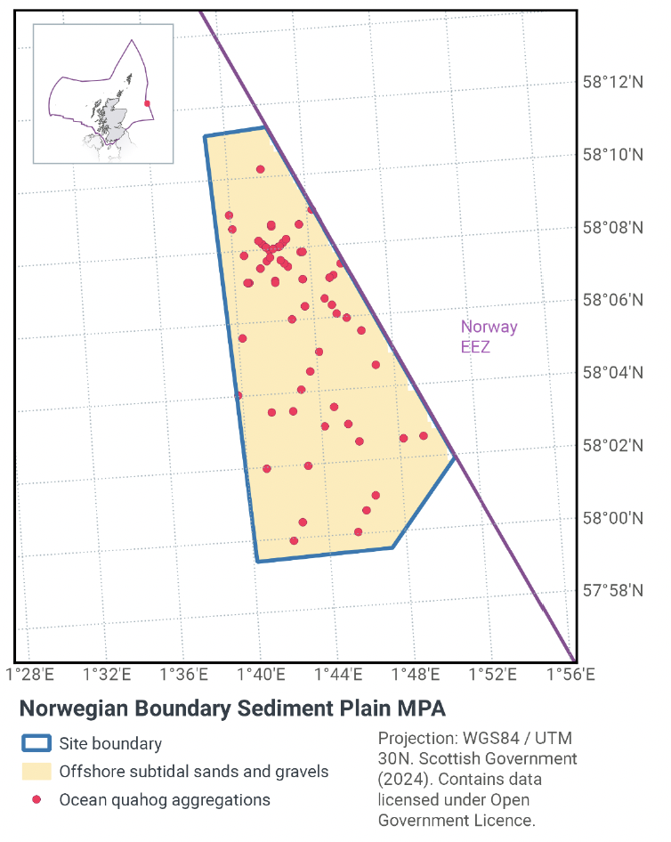
The Norwegian Boundary Sediment Plain NCMPA (Figure 1) lies to the east of Scotland, adjacent to the offshore limit of UK waters. A sandy plain in relatively shallow waters, the site ranges in depth from 80 - 120 m below sea-level. The NCMPA is designated for Ocean quahog aggregations (including sands and gravels as their supporting habitat).
The Norwegian Boundary Sediment Plain NCMPA covers 164 km2 and is home to a range of animals that live both in and on the sand and gravel habitats such as starfish, crabs, and the long-lived ocean quahog (Arctica islandica); the latter of which is considered to be Threatened and/or Declining across the North-east Atlantic by the OSPAR Commission. Ocean quahog filter food from passing currents and can use a shovel-like foot to bury into the sediment. They can burrow deep into the sediment to escape predators and live for long periods of time without food or oxygen.
Ocean quahog are documented as a potential food source for several species of fish including cod. Although they are not specific to one type of habitat, sands and gravels are the ocean quahog's preferred habitat. The main threat to ocean quahog is disturbance of the seabed, most often from bottom fishing activities, but licensed activities, such as oil, gas and aggregate extraction, can also directly and indirectly affect this species.
Offshore subtidal sand and gravel habitats are also protected to support the protection of ocean quahog in the context of providing habitat suitable for ocean quahog colonisation. Ocean quahog are typically found buried in medium- to fine-grained sands, sandy mud and silty sand in water depths of 4–400 m. Survey data from this NCMPA have confirmed the presence of ocean quahog within the depth range and sediment types in which they are expected to occur.
The conservation objectives for the Norwegian Boundary Sediment Plain Nature Conservation Marine Protected Area (NCMPA) are that the protected features:
- so far as already in favourable condition, remain in such condition; and
- so far as not already in favourable condition, be brought into such condition, and remain in such condition.
JNCC’s view on the overall condition of the site’s qualifying features is that the features are in unfavourable condition.
With respect to the Ocean quahog aggregations (including supporting sedimentary habitats) within the NCMPA, this means that the quality and quantity of its habitat and the composition of its population in terms of number, age and sex ratio are such as to ensure that the population is maintained in numbers which enable it to thrive.
Any temporary reduction of numbers is to be disregarded if the population is sufficiently thriving and resilient to enable its recovery. Any alteration to that feature brought about entirely by natural processes is to be disregarded.
Further information regarding the designation and conservation objectives for the protected features of Norwegian Boundary Sediment Plain NCMPA is available on the JNCC Norwegian Boundary Sediment Plain NCMPA webpage.
1.3 Activities assessed
The assessments consider the impacts of fisheries activities at each NCMPA in terms of the conservation objectives stated for the designated sites. This was deemed appropriate in order to assist in identifying potential management measures.
In this context, the implications of the fishing activity in view of the conservation objectives for the NCMPA are being assessed through the fisheries screening stage (Part A), the fisheries assessment (Part B), and the in combination (cumulative effect) assessment (Part C).
Fisheries assessments use the best available evidence to fully consider potential impacts of commercial fishing activity, and in-combination (cumulative) effects with other activities, against the conservation objectives for the site. If the assessment concludes that use of certain fishing gear types would or might hinder the achievement of the conservation objectives of the site, management measures will be considered.
Commercial sea fishing activity has the potential to vary in nature and intensity over time. This assessment considers fishing activity based on activity levels and type between 2015-2019. This date range was considered to provide the best available data on current fishing activity levels for the assessment. Using a five-year date range provides an average view of fishing activity within the site; latter years (2020 – 2021) were not considered representative of regular fishing activity due to the Covid pandemic. The selected date range (2015 – 2019) was used consistently across all assessments within the consultation package. Changes in fishing activity after this time period may be considered in future reviews of this assessment (see Section 6).
Contact
Email: marine_biodiversity@gov.scot
There is a problem
Thanks for your feedback