Draft Fisheries Assessment – Norwegian Boundary Sediment Plain NCMPA: Fisheries management measures within Scottish Offshore Marine Protected Areas (MPAs)
These assessments look at the fishing activity occurring within each offshore MPA and SAC and assess the potential impacts of this activity on the protected features within each site. This assessment is for Norwegian Boundary Sediment Plain NCMPA.
4. Part C Assessment – In Combination Assessment
Part C of this assessment considers the cumulative impacts, which may occur over space and time, in relation to activities occurring within the NCMPA. Activities assessed in this section include the following:
- Fishing activity/pressure combinations which were excluded in Part A of this assessment as not being capable of impacting;
- Fishing interactions assessed in Part B that would not hinder the conservation objectives for the site; and
- Activities occurring within Norwegian Boundary Sediment Plain NCMPA that are not related to fishing.
Demersal trawls and demersal seines were not considered to hinder the achievement of conservation objectives on their own and so they are assessed in combination with other activities occurring at the site in this Part C.
4.1 In-combination assessment overview
4.1.1 Other offshore region activities screening
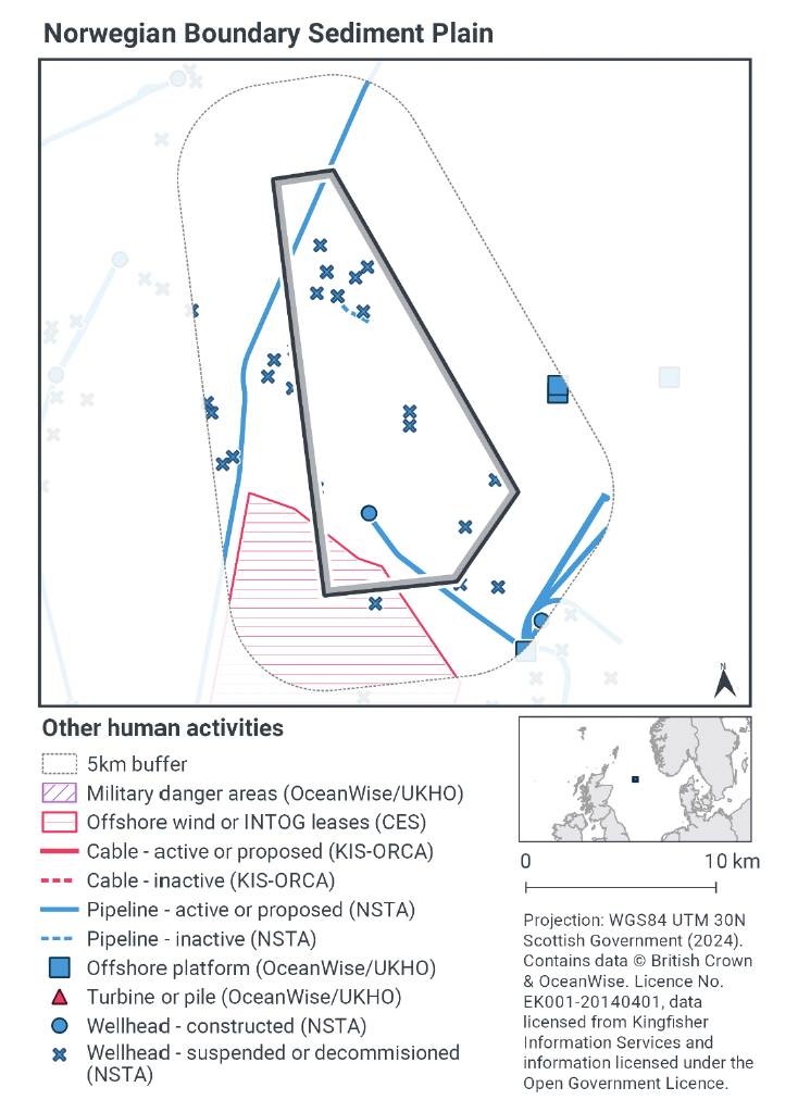
To determine activities, not related to fishing activities, to be included within this part of the assessment, a distance of 5 km was selected as suitable to capture any potential source receptor pathways that could impact the site in combination with effects of the fishing activities assessed. A 5 km buffer was therefore applied to the site boundary to identify relevant activities.
Activities not related to fishing activities were identified using the Scottish Government’s marine mapping tool. The JNCC Conservation Advice package, and other resources on the JNCC Site Information Centre for Norwegian Boundary Sediment Plain NCMPA, were also screened for activities occurring in the site that should be considered in the in-combination assessment.
The map to display offshore region activities (see Fig. 6) was derived from OceanWise’s Marine Themes Vector data (July 2023 version), Crown Estate Scotland leases (September 2023 version), Kingfisher Information Services Offshore Renewable Cable Awareness (KIS-ORCA, as of December 2023 held under licence) and North Sea Transition Authority (NSTA, as of December 2023, data held under Oil and Gas Authority open licence). The Marine Themes “Industrial” was filtered to show offshore region platforms, wellheads, piles, turbines, cables, and pipelines. Features marked as “not in use”, “not present”, “decommissioned”, or “removed” were excluded. The “Administrative” data were filtered to only show military exercise areas which included danger areas.
4.1.2 Other offshore region activities occurring within Norwegian Boundary Sediment NCMPA
The screening exercise using the Scottish Government’s marine mapping tool identified a number of other offshore activities taking place within the site or within 5 km of the site boundary. The activities found were one active and multiple decommissioned well heads, one active gas pipeline, one hydrocarbon pipeline and a decommissioned pipeline.
Screening did not identify any current cables, turbines or piles, or offshore region platforms within the site (Figure 4). An offshore platform is located approximately 5 km east of the site along with further pipelines.
An offshore region site for Innovation and Targeted Oil and Gas (INTOG) overlaps the southern west corner of the site. This is an area where projects targeting oil and gas decarbonisation will be considered however there are currently no proposed projects, or infrastructure in place for this site and subsequently these were not deemed to have potential for in-combination effects at this point in time. The UK oil and gas regulator Offshore Petroleum Regulator for Environment and Decommissioning would be responsible for making the decision on whether a proposed activity and/or development is capable of affecting the protected features of a Nature Conservation NCMPA.
4.2 Potential pressures exerted by fishing and other activities
Risks associated with oil and gas production and pipelines were assessed for the active wellhead and pipelines in the site. The active pipelines are currently in place, removing the risk of any pressures associated with laying, burial and protection, or decommissioning.
The JNCC PAD indicated six pressures exerted by oil and gas infrastructure operation and maintenance, and pipelines to be of a medium-high risk. Those that are considered a low risk are not assessed.
The six pressures are:
- Abrasion/disturbance of the substrate on the surface of the seabed;
- Penetration and/or disturbance of the substrate below the surface of the seabed, including abrasion;
- Habitat structure changes – removal of substratum (extraction);
- Introduction of other substances (solid, liquid or gas);
- Hydrocarbon & PAH contamination. Includes those priority substances listed in Annex II of Directive 2008/105/EC and;
- Smothering and siltation rate changes (light).
Three of these pressures above overlap with those exerted by demersal trawls and seines; abrasion/disturbance of the substrate on the surface of the seabed;
penetration and/or disturbance of the substrate below the surface of the seabed, including abrasion and smothering and siltation rate changes (light). These three pressures will be assessed in section 4.5.
4.3 Significance of effects/impact to protected features
Of the pressures identified, the protected features of the site are considered to be sensitive to three of these. These three pressures are Abrasion/disturbance of the substrate on the surface of the seabed; Penetration and/or disturbance of the substrate below the surface of the seabed, including abrasion and Smothering and siltation rate changes (Light) and also overlap with those exerted by demersal trawls and demersal seines.
As the pipelines are in situ and therefore not subject to pressures related to laying or decommissioning, the pressures identified in section 4.4 occur where the pipeline needs to be reburied or uncovered for repair. The frequency of the activity will be very low.
The active wellhead is located in the south west corner of the site, there is very little fishing activity occurring here at less than 12 hours per year per grid cell of demersal trawl or demersal seine annually. When taking into account the additional pressure exerted by fishing activity, in combination with pressures exerted by activity around the wellhead, this is likely to be a minimal increase in pressure.
Licensable activities such as oil and gas exploration and production taking place or that may take place within this NCMPA are managed in accordance with the clauses set out under Section 126 of The Marine & Coastal Access Act (2009). Under this clause, JNCC has a statutory responsibility to advise the regulator on developments that are capable of impacting the protected features of the NCMPA and that may hinder the achievement of the site's conservation objectives. JNCC considers the existing marine licensing process is sufficient to ensure the management of licensable activities taking place, or that could take place in the future, on the protected features of this NCMPA.
All these pressure-feature interactions for the fishing gears were not considered likely to affect the protected features of the site in Part B for the fishing activity levels within the site. When taken into account with the pressures exerted by oil and gas infrastructure operation and maintenance, and pipelines, as the frequency of the activity is considered to be very low, no further management is considered.
Accordingly, the assessment did not identify any in-combination activities that were considered likely to affect the protected features of the site of Norwegian Boundary Sediment Plain NCMPA.
4.4 Part C conclusion
Scottish Ministers conclude that the remaining fishing activities (demersal trawl and demersal seine) in-combination with other relevant activities will not hinder the achievement of the conservation objectives for Norwegian Boundary Sediment Plain NCMPA.
Contact
Email: marine_biodiversity@gov.scot
There is a problem
Thanks for your feedback