Draft Fisheries Assessment – Pobie Bank Reef SAC: Fisheries management measures within Scottish Offshore Marine Protected Areas (MPAs)
These assessments look at the fishing activity occurring within each offshore MPA and SAC and assess the potential impacts of this activity on the protected features within each site. This assessment is for Pobie Bank Reef SAC.
1 Introduction
1.1 Scope of the Pobie Bank Reef SAC assessment
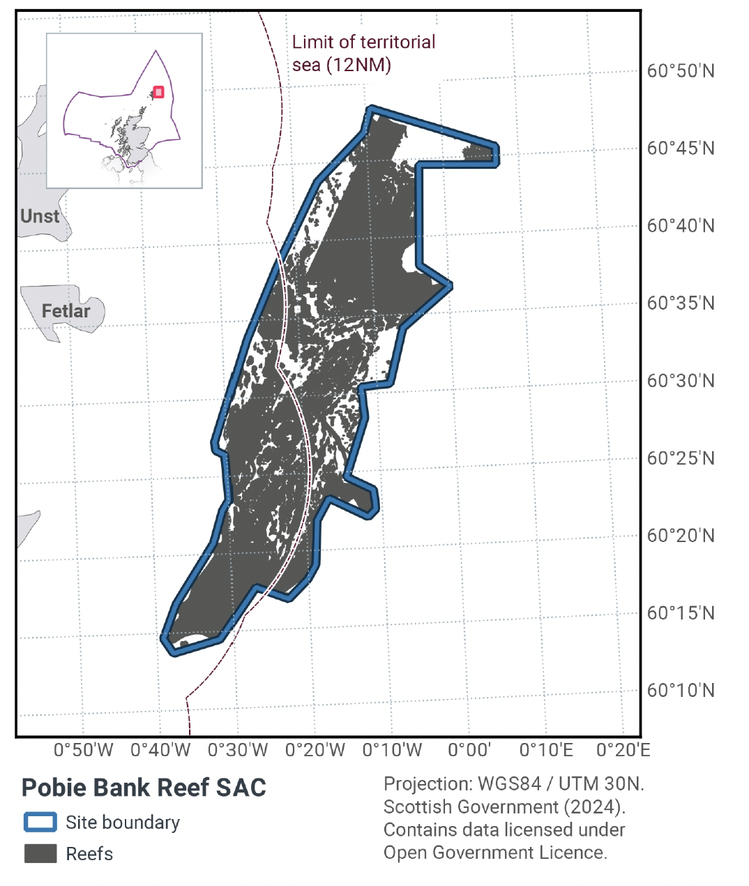
The geographic scope of this assessment covers the whole of the Pobie Bank Reef SAC, including portion within both the offshore (12-200 nautical mile, nm) and inshore regions (0-12 nm) (Figure 1). The purpose of this assessment is to determine whether the current levels of fishing activity occurring within the site are compatible with the conservation objectives of the Pobie Bank Reef SAC and to identify options for management measures.
In this assessment, Scottish Ministers use the best available evidence to review the site characteristics and current fishing activity (Part A), both taken alone and in combination with other relevant activities (Part C) to determine if there is the potential for these activities to have a likely significant effect (LSE) on the protected feature of the site (Annex I Reef). Any fishing activities with the potential for LSE, either alone or in combination with other relevant activities, are considered further to assess whether they could result in an adverse effect on site integrity (Part B).
Where there is the potential for an adverse effect on site integrity, management measures are identified for the site by Scottish Ministers.
These measures are considered in light of the conservation objectives, biological characteristics of the protected features, current activity levels, and existing fisheries restrictions for Pobie Bank Reef SAC. A final decision on which measures, if any, are to be adopted, will follow upon a statutory consultation exercise and will take into account all relevant statutory obligations incumbent upon Scottish Ministers.
A methodology document has been prepared to aid understanding of these draft assessments.
1.2 Site description
Pobie Bank Reef SAC (Figure 1) is located in the North Sea approximately 20 km east of Unst, Fetlar and Whalsey in Shetland, and is separated from Shetland by the Unst Basin. The SAC is approximately 70 km long (crest running NNE to SSW) and up to 21 km wide, with an area of 856 km2. Depth within the site ranges from 70 m to over 100 m; the average seabed depth within the site boundary is approximately 90 m. The reef is located on a bank of metamorphic and sedimentary rocks covered by a patchy veneer of sediment, ranging from sandy gravels to slightly gravelly sands. The bank overlays a flat plain of sedimentary rock, known as the East of Shetland Platform. The site lies across the 12 nm territorial sea limit and therefore advice is jointly delivered by the Joint Nature Conservation Committee (JNCC) and Scottish Natural Heritage (operating name of and hereinafter referred to as NatureScot).
In the central section of the reef, very large, rugged bedrocks outcrop from areas of sand and this represents the most topographically complex area. In most areas these outcrops are surrounded by large boulders and cobbles in a sandy matrix. Towards the north and south of the reef, bedrock outcrops are smoother and integrated with extensive areas of stony reef.
Pobie Bank reef’s stony and bedrock reef (Table 1; Figure 1) provides a habitat to an extensive community of encrusting and robust sponges and bryozoans, which are found throughout the site. In the shallowest areas the bedrock and boulders also support encrusting coralline algae. Axinellid cup sponges (Axinella infundibuliformis) are common on the bedrock and stony reef at depth ranges of 70 m to over 100 m. The bryozoan Omalosecosa ramulosa is also common on these reefs, but this species is rare in inshore sites in the Northern North Sea regional sea. In the deepest areas (greater than 100 m), low-lying silty bedrock is commonplace, supporting small erect sponges, cup corals (Caryophyllia (Caryophyllia) smithii) and the brittlestar Ophiura albida.
The Pobie Bank Reef SAC provides geographic representation of the Annex I reef habitat in Scottish seas, and is one of eight SACs hosting this feature in Scottish seas. The Pobie Bank Reef SAC is located in OSPAR Region II, within which there are five protected areas for this feature.
The Conservation Objectives for the Annex I Reef at Pobie Bank Reef are:
Subject to natural change, maintain or restore the reef in/to favourable condition, such that:
- the natural environmental quality and processes supporting the habitat
- the extent of the habitat on site
- the physical structure, community structure, function, diversity and distribution of the habitat and typical species representative of the reef in the Northern North Sea regional sea
are maintained or restored, thereby ensuring the integrity of the site, and also making an appropriate contribution to favourable conservation status of the Annex 1 habitats (see ‘Conservation Objectives and Advice on Operations (2013)’ in the Pobie Bank Reef MPA: Relevant Documentation & Conservation Advice 2013).
The condition of the reef feature at Pobie Bank Reef SAC is uncertain, resulting from a lack of detailed information on levels of exposure to human activities and their ecological impact on the feature at this site. Further information will be required to assess and monitor favourable condition of the reef feature at this offshore region SAC. There is no direct evidence to date that the feature has been damaged by human activities (as at 2013). The most recent survey of Pobie Bank Reef SAC was completed in 2023. However, analysis of that survey is ongoing and not currently available to use in this assessment. The best available evidence indicates that demersal fishing occurs over the reef feature, exposing it to pressures to which it is sensitive and subsequently it is assessed as moderately vulnerable. Although it is likely that bottom trawlers avoid the hard substrate to prevent damage to their gear, according to NatureScot and JNCC Conservation Objectives and Advice on Operations, the best available evidence (as at 2013) was not of sufficient spatial resolution to confirm this and so the objective was set to maintain or restore.
More information regarding the conservation objectives for the protected features of Pobie Bank Reef SAC is available in the NatureScot and JNCC Conservation Objectives and Advice on Operations for the site.
| Reef type | Habitat area within SAC (km2) |
|---|---|
| Bedrock (high confidence) | 166.1 |
| Stony (high confidence) | 107.2 |
| Bedrock and stony (high confidence) | 305.2 |
| Bedrock (potential) | 69.1 |
| Total | 647.7 |
1.3 Activities assessed
The process followed to conduct this ‘Fisheries Assessment’ is in line with the process for a Habitats Regulation Appraisal, as required under Article 6(3) of Council Directive 92/43/EEC of 21 May 1992 on the conservation of natural habitats and of wild fauna and flora (the Habitats Directive); for sites within the offshore region under Regulation 28 of the Conservation of Offshore Marine Habitats and Species Regulations 2017; and for sites wholly or partly within the inshore region under Regulation 48(1) of the Conservation (Natural Habitats, & c.) Regulations 1994.
In this context, fishing activity within the SAC is considered to be the plan or project, and the implications of the fishing activity in view of the conservation objectives for the SAC are being assessed through the fisheries screening stage (Part A), the fisheries assessment (Part B), and the in combination (cumulative effect) assessment (Part C).
Fisheries assessments use the best available evidence to fully consider potential impacts of commercial fishing activity, and in-combination (cumulative) effects with other plans and projects, against the conservation objectives for the site. If the assessment concludes that use of certain fishing gear types is not compatible with the conservation objectives of the site, management measures will be considered.
Commercial sea fishing activity has the potential to vary in nature and intensity over time. This assessment considers fishing activity based on activity levels and type between 2015-2019. This date range was considered to provide the best available data on current fishing activity levels for the assessment. Using a five-year date range provides an average view of fishing activity within the site; latter years (2020 – 2021) were not considered representative of regular fishing activity due to the Covid pandemic. The selected date range (2015 – 2019) was used consistently across all assessments within the consultation package. Changes in fishing activity after this period may be considered in future reviews of this assessment (see Section 6).
Contact
Email: marine_biodiversity@gov.scot
There is a problem
Thanks for your feedback