Draft Fisheries Assessment – Pobie Bank Reef SAC: Fisheries management measures within Scottish Offshore Marine Protected Areas (MPAs)
These assessments look at the fishing activity occurring within each offshore MPA and SAC and assess the potential impacts of this activity on the protected features within each site. This assessment is for Pobie Bank Reef SAC.
3 Part B Assessment – Fisheries assessment
3.1 Fisheries assessment overview
Part B of this assessment meets the requirements for an appropriate assessment under Article 6(3) of the Habitats Directive 1992 and Regulation 28 of the Conservation of Offshore Marine Habitats and Species Regulations 2017, and Regulation 48(1) of the Conservation (Natural Habitats, & c.) Regulations 1994.
The fishing activities identified in Part A, at the levels identified in the relevant date range, which have been included for assessment in Part B are mobile demersal fishing (trawls and seines) and static demersal fishing (anchored nets/lines). The only pressures associated with these fishing activities that have been included in Part B are:
- Abrasion/disturbance of the substrate on the surface of the seabed;
- Penetration and/or disturbance of the substrate below the surface of the seabed; including abrasion (except for anchored nets/lines);
- Changes in suspended solids (water clarity) (except for anchored nets/lines);
- Smothering and siltation rate changes (light) (except for anchored nets/lines);
- Removal of target species (except for trawls and seines); and
- Removal of non-target species.
3.2 Fishing activity descriptions
3.2.1 Existing management within Pobie Bank Reef SAC
No existing fisheries management measures or other fisheries restrictions were identified within the site.
3.2.2 Fishing activity within Pobie Bank Reef SAC
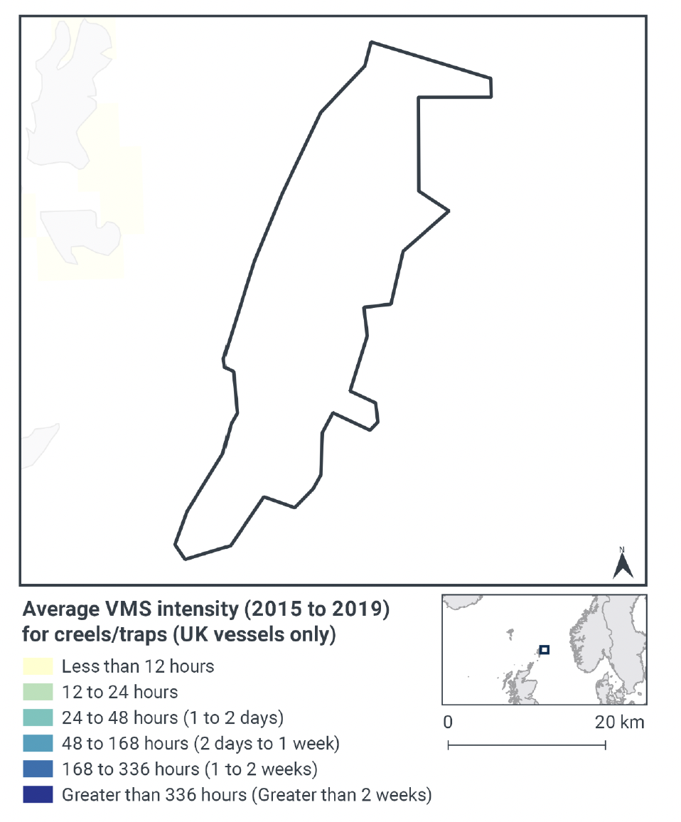
The Pobie Bank Reef SAC overlaps ICES rectangles 49E9, 50E9 and 50F0 in the Northern North Sea (ICES Division 4a), in the East Shetland region. The aggregated gear methods used by UK vessels in this site are demersal trawls, demersal seines, anchored nets/lines and pelagic fishing (Table 2, in Section 2 - Part A). The NatureScot and JNCC Conservation Objectives and Advice on Operations for the site (published 2013), suggested that creeling may take place in the site, although there were no data on the intensity of creeling in the area at that time. Analysis of more recent VMS data (2015 – 2019) did not identify any creeling activity in the site for vessels over 12 m (Figure 2). Based on data from 2015 – 2019, fishing with pots and traps on vessels under 12 m does occur within Pobie Bank Reef SAC. However, as stated in the section 2.2 given the errors with the positional information for these data and lack of intensity information associated with the data, the decision was made to exclude them from the assessment.
Pelagic fishing (mid-water trawls) was not considered capable of affecting the reef feature of Pobie Bank Reef SAC and so is not considered further (see JNCC Fisheries Management Options Paper: Pobie Bank Reef Special Area of Conservation): demersal trawls, demersal seines, and anchored nets/lines are considered in more detail in the following sections.
In addition to UK activity, vessels from Norway (40 vessels), France (22 vessels), Denmark (13 vessels), Germany (10 vessels) and Netherlands (8 vessels) may also operate in the site, based on VMS data from 2015-2019. However, it is not possible to accurately determine the gear types associated with the VMS data for these non-UK vessels, or whether they were actively fishing at the time.
3.2.3 Demersal trawls
The aggregated gear method of demersal trawls includes multiple gears that operated within the Pobie Bank Reef SAC between 2015 and 2019. These include bottom otter trawls, multi-rig trawls, pair trawls, and other not specified bottom trawl types. Similar pressures are exerted by the different gears used for demersal trawling, subsequently the aggregated gear type of ‘demersal trawl’ was used to map activity across the site.
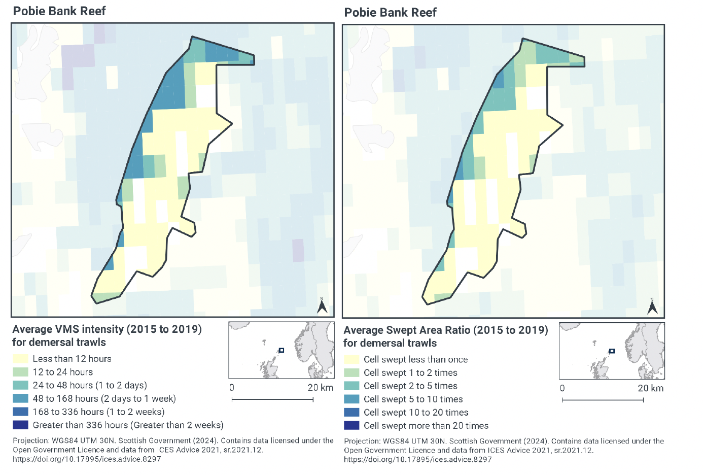
According to the VMS, intensity averaged over 2015 to 2019 (Figure 3), demersal trawling is concentrated in the north, northwest and west part of the site (48 – 168 fishing hours per year per grid cell), with additional areas of higher intensity in the north and northwest of the site (24 – 48 fishing hours per year per grid cell). Small areas of lower fishing activity also occur in the north, west, south and east of the site (12 – 24 fishing hours per year per grid cell). The remainder of the site, particularly the east, central potion, and south, has lower fishing intensity (less than 12 fishing hours per year per grid cell). These activity levels are comparable to fishing activity information within the NatureScot and JNCC Conservation Objectives and Advice on Operations for the site, where VMS data indicated otter trawling effort was relatively low (not exceeding an average of 50 hours per year per grid cell over the period 2006 – 2009).
Swept-Area Ratio (SAR) information averaged over the same time period shows similar patterns of fishing intensity as the VMS data (Figure 3). The highest SAR values are in the northwest and west (cells swept 5 – 10 or 2 – 5 times per year per grid cell). Small areas of lower fishing activity also occur in the north, west, south, and east of the site (cells swept 1 – 2 times per year per grid cell). The remainder of the site, particularly the east, central potion, and south, had low SAR values (cells swept less than once per year per grid cell).
The locations identified as having higher fishing intensity through VMS and SAR; particularly in the northeast, central-east, and southeast; have the potential to overlap with the reef feature.
3.2.4 Demersal seines
Scottish fly/seine and anchor seine were the two gear types within the aggregated demersal seine gear type that were operating within the Pobie Bank Reef SAC between 2015 and 2019. Fishing with these gears is referred to as the aggregated gear type of ‘demersal seines’ in the following sections to align with the approach taken for the rest of the assessment.
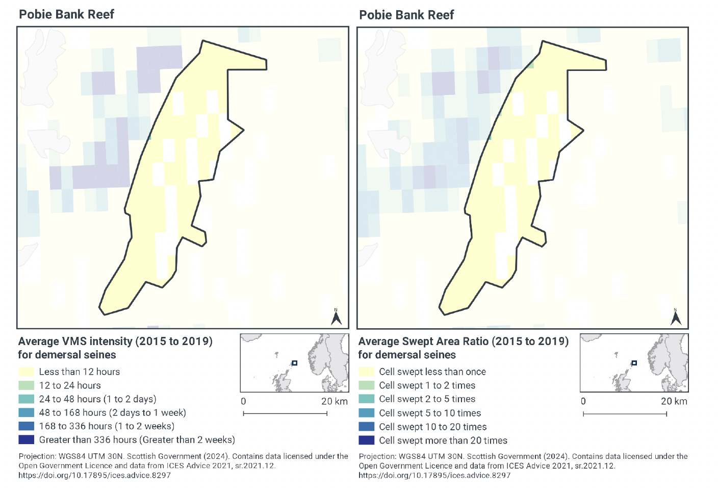
According to the VMS, intensity averaged over 2015 to 2019, there are very low levels of demersal seine activity occurring across the site, apart from some central areas where no activity was recorded. Except for one very small patch on the west of the site, fishing intensity is less than 12 hours annually throughout the site (Figure 4).
Swept-Area Ratio (SAR) information averaged over the same time period shows similar patterns of fishing intensity as the VMS data (Figure 4). Except for a few small patches on the west of the site with slightly higher values, SAR values were low throughout the site (cells swept less than once annually).
Overlap with the reef feature is possible across the parts of the site where fishing activity occurs.
3.2.5 Anchored nets/lines
The aggregated gear method of anchored nets/lines includes multiple gears that operated within the Pobie Bank Reef SAC between 2015 and 2019. These include set gillnets, longlines (not specified), set longlines, and hooks and lines (not specified). Fishing with these gears is referred to as the aggregated gear type of ‘anchored nets/lines’ in the following sections to align with the approach taken for the rest of the assessment.
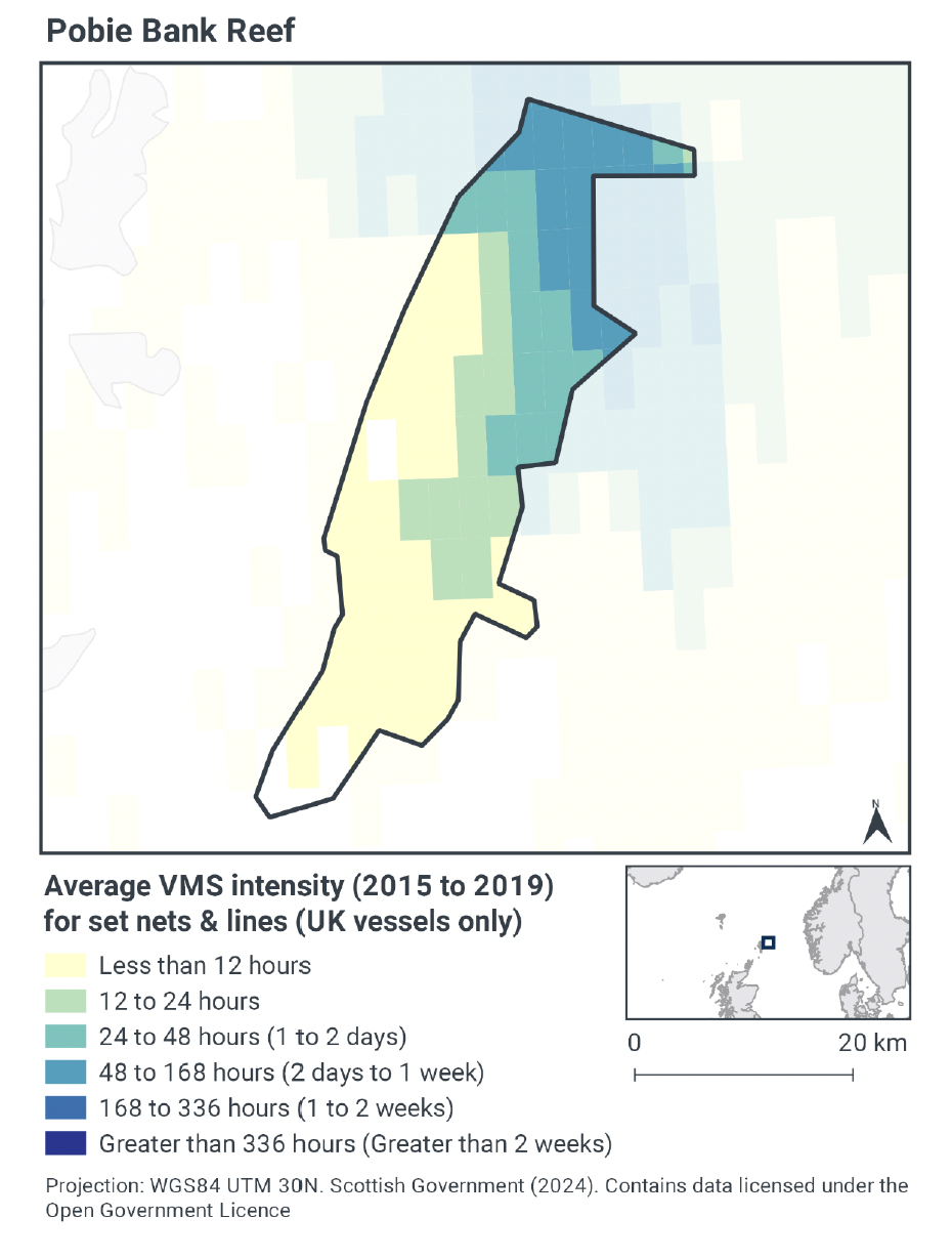
According to the VMS, intensity averaged over 2015 to 2019, anchored nets/lines occurred throughout the site, except for the far south of the site and a small area on the west (Figure 5). The highest concentration of anchored nets/lines was in the northeast (48 – 168 fishing hours per year per grid cell), decreasing in intensity moving southwest towards the centre of the site (24 – 48 through to 12 – 24 fishing hours per year per grid cell). The remainder of the site from the centre to the southwest is fished at lower levels (less than 12 fishing hours per year per grid cell).
Swept-Area Ratio information is not available for static fishing, such as anchored nets/lines. Based on the VMS data, anchored nets/lines have the potential to overlap with the reef feature, including in the areas of higher fishing activity.
3.2.6 Fishing activity summary
Fishing activities using demersal trawls, demersal seines, and anchored nets/lines all occur within the Pobie Bank Reef SAC. Demersal trawling occurs at higher intensity in the north, northwest, and west of the site. Demersal seines are used at low levels throughout the site. Anchored nets/lines are deployed at higher intensity in the north and northeast of the site. There is the potential for all of these gear types to overlap with the reef feature.
3.3 Fishing activity effects overview
The following sections explore the pressures associated with fishing activity (demersal trawls, demersal seines, anchored nets/lines) within the Pobie Bank Reef SAC that were identified as potentially having likely significant effects (LSE) on the reef feature. The pressures considered in the following sections are:
- Abrasion/disturbance of the substrate on the surface of the seabed;
- Penetration and/or disturbance of the substrate below the surface of the seabed; including abrasion (except for anchored nets/lines);
- Changes in suspended solids (water clarity) (except for anchored nets/lines);
- Smothering and siltation rate changes (light) (except for anchored nets/lines);
- Removal of target species (except for trawls and seines); and
- Removal of non-target species.
These six pressures were associated with mobile demersal fishing activity (trawls and seines) and static demersal fishing (anchored nets/lines) and are discussed under the aggregated fishing gear types of ‘mobile demersal gears’ and ‘static demersal gear’. Five of these pressures, with the exception of removal of target species, have the potential to be exerted by mobile demersal gear. The two pressures attributed to static demersal gear are abrasion/disturbance of the substrate on the surface of the seabed and removal of non-target species.
Given the absence of a detailed JNCC Advice on Operations spreadsheet for this site, the detailed pressure information for this section is based on information from JNCC PAD and the Advice on Operations spreadsheet for Stanton Banks which is also designated for Annex I Reefs.
3.3.1 Impacts of mobile demersal gears (trawls and seines) on Annex I Reef
As detailed in the JNCC Marine Pressures-Activities Database (PAD) v1.5 2022, abrasion/disturbance of the substrate on the surface of the seabed occurs where gear makes contact with the seafloor. The area affected is determined by the footprint of the gear and the amount of movement across the seabed. The different gear components will make variable contributions to the total physical disturbance of the seabed and its associated biota, and hence the pressure will vary according to factors such as gear type, design/modifications, size and weight, method of operation (including towing speed) and habitat characteristics (e.g. topography) (Lart, 2012; Polet & Depestele, 2010; Suuronen et al., 2012). Towed bottom fishing gears are used to catch species that live in, on or in association with the seabed and therefore are designed to remain in close contact with the seabed. That interaction with the seabed can lead to disturbance of the upper layers of the seabed, direct removal, damage, displacement or death of the benthic flora and fauna; short-term attraction of scavengers; and the alteration of habitat structure (Kaiser et al., 2003; Gubbay & Knapman, 1999; Sewell & Hiscock, 2005; Collie et al., 2000; Kaiser et al., 2002).
Benthic seines are generally of lighter construction as there are no trawl doors or warps, resulting in less disturbance of the seabed than trawling (Polet & Depestele, 2010; Donaldson et al., 2010; Suuronen et al., 2012). As a relative comparison of gear types, otter trawls tend to have less physical impact on the seafloor than beam trawls (and dredges) with their heavy tickler chains, although the doors of an otter trawl do create recognisable scour of the seabed (Hinz et al., 2012; Polet & Depestele, 2010; Lart, 2012; Paschen et al., 2000). The magnitude of the immediate response to fishing disturbance, cumulative effects and recovery times varies significantly according to factors such as the type of fishing gear and fishing intensity, the habitat and sediment type, and levels of natural disturbance and among different taxa (Collie et al., 2000; Boulcott et al., 2014; Kaiser et al., 2006; Hinz et al., 2009; Kaiser et al., 2001).
Changes in suspended solids and siltation rates may result from physical disturbance to the seabed, along with hydrodynamic action caused by the passage of towed gear, leading to entrainment and suspension of the substrate behind and around the gear components and subsequent siltation (Sewell et al., 2007; Gubbay & Knapman, 1999; Lart, 2012; Kaiser et al. 2002; Riemann & Hoffmann, 1991; O’Neill et al., 2008; Dale et al., 2011; O’Neil & Summerbell, 2011. The quantity of suspended material and its spatial and temporal persistence will depend on factors associated with the gear (e.g. weight, towing speed), sediment (e.g. particle size composition), the intensity of the activity and the background hydrographic conditions (Sewell et al., 2007; Kaiser et al., 2002).
Turbid plumes can reduce light levels while sediment remobilisation and deposition can affect the settlement, feeding and survival of biota through smothering of feeding and respiratory organs. Prolonged exposure of an area to these pressures may result in changes in sediment composition (Sewell et al., 2007; Gubbay & Knapman, 1999; Kaiser et al., 2002; O’Neil & Summerbell, 2011).
Bycatch (i.e. discarded catch) is associated with almost all fishing activities and is related to factors such as gear type and its design (i.e. its selectivity), the target species and effort. There are significant concerns over the impacts of discards on marine ecosystems including changes in population abundance and demographics of affected species and altered species assemblages and food web structures (Alverson et al., 1994; Kaiser et al., 2001). As with other benthic towed gears, discarding of fish species from demersal seine net fisheries can be significant (Polet & Depestele, 2010; ICES, 2011). These are relatively few studies of the non-fish bycatch composition for demersal seines, however, it is probably similar to that of demersal trawls e.g. crustaceans and other invertebrates, etc., although quantities of such bycatch are likely to be lower than that of other gear types such as beam trawls (Suuronen et al., 2012; ICES, 2011; Donaldson et al., 2010; Walsh & Winger, 2011). Mixed-species and shrimp/prawn demersal trawl fisheries are associated with the highest rates of discarding and pose the most complex problems to resolve (Alverson et al., 1994; Feekings et al., 2012; Catchpole et al., 2005). Benthic trawls most frequently result in bycatch of fish crustaceans and other invertebrates and less frequently turtles and birds (Gubbay & Knapman, 1999; Sewell & Hiscock, 2005; ICES, 2013; Pierpoint, 2000; Bergmann & Moore, 2001; Catchpole et al., 2005; Tulp et al., 2005).
As detailed in the JNCC Fisheries Management Options Paper: Pobie Bank Reef Special Area of Conservation, whilst it is unlikely that mobile bottom contact gear can affect the long-term natural distribution of bedrock and stony reef features, there is evidence to indicate that the use of bottom contacting mobile gears can impact the structure and function of the habitat and the long term survival of its associated species. The use of towed fishing gears is likely to cause damage or death of fragile, erect species, such as sponges and corals (Løkkeborg, 2005; Freese et al., 1999). Other species such as hydroids, anemones, bryozoans, tunicates, and echinoderms may also be vulnerable (McConnaughey et al., 2000; Sewell & Hiscock, 2005). Where fragile, slow growing species occur, even low levels of fishing have the potential to change the structure and function of the habitats and may result in the loss of some characteristic species.
According to the NatureScot and JNCC Conservation Objectives and Advice on Operations for the site (published 2013), the reef may be exposed to physical disturbance and abrasion due to otter trawling and this extends over the reef feature, primarily targeting pockets of interspersed sediment throughout the reef. Scottish seine fishing occurs in the site but has lower abrasion pressure compared to demersal trawling. Set gillnetting and longlining fishing also occur over the feature targeting demersal species, although it is considered likely that any boats conducting longlining would be drifting as opposed to anchoring. The most recent NatureScot and JNCC Conservation Objectives and Advice on Operations for the site indicated that mobile demersal fishing (including demersal trawling and demersal seining) poses a high risk to the Pobie Bank reef feature. The Pobie Bank reefs and associated biological communities were assessed as moderately vulnerable to 1) physical damage through physical disturbance or abrasion; and 2) biological disturbance through selective extraction of species, resulting from demersal fishing.
Considering the current levels of mobile demersal trawl and seine fishing activity within the site, and information on the impacts of abrasion/disturbance of the substrate on the surface of the seabed and removal of non-target species, demersal trawling and demersal seining are causes for concern for the reef feature of Pobie Bank Reef SAC. This aligns with the 2023 JNCC Fisheries Management Options Paper: Pobie Bank Reef Special Area of Conservation, which advises that the option of ‘no additional management’ for mobile demersal fishing would pose significant risk of not achieving the conservation objectives for the reef feature.
There is a risk that abrasion/disturbance of the substrate on the surface of the seabed and removal of non-target species caused by mobile demersal gear (trawls and seines) may not help the achievement of favourable condition. Even if the impacts across gear types vary, mobile demersal fishing gears are likely to have negative impacts on biological communities across the Pobie Bank Reef SAC and these gears are not considered compatible with restoring the Annex I reef feature to favourable condition.
Through physical impacts from gear interacting with the seabed, mobile demersal gear has the potential to affect maintaining or restoring reef in/to favourable condition, such that the natural environmental quality and processes supporting the habitat, the extent of the habitat on site, and the physical structure, community structure, function, diversity and distribution of the habitat and typical species representative of the reef in the Northern North Sea regional sea are maintained or restored. Accordingly, Scottish Ministers conclude that demersal trawls and seines are not compatible with the conservation objectives of the site at current activity levels and may result in an adverse effect on site integrity.
3.3.2 Impacts of static demersal gears (anchored nets/lines) on Annex I Reef
As detailed in the JNCC Marine Pressures-Activities Database (PAD) v1.5 2022, abrasion/disturbance of the substrate on the nets/lines themselves and any footropes and anchors. This is most likely to happen during retrieval of the gear if it is dragged along the seabed before ascent, although disturbance of the seabed can occur while the gear is fishing if movement (particularly of any anchors) occurs during rough weather, for example, or otherwise. Such physical disturbance can result in epifauna, especially emergent species such as erect sponges and coral, being dislodges (including snagged in the net) or damaged, although there are limited studies of such effects (Lart, 2012; Polet & Depestele, 2010; Sewell & Hiscock, 2005; Suuronen et al., 2000; Auster & Langton, 1999).
Bycatch (i.e. discarded catch) is associated with almost all fishing activities and is related to factors such as the gear type and its design (i.e. its selectivity), the targeted species and effort. Anchored nets, including gill and trammel nets, can result in the entanglement and bycatch of a range of fauna including mammals, turtles, fish, elasmobranchs, crustaceans and other invertebrates and birds (Gubbay & Knapman, 1999; ICES, 2013; WWT, 2012; Žydelis et al., 2009; Pierpoint, 2000; Oliver et al., 2015) the consequences of which can be significant to species and populations (Reeves et al., 2013; Furness, 2003; Tasker et al., 2000). Further, ghost fishing has been associated with lost gear (Matsuoka et al., 2005). Although highly selective for the larger pelagic fish, longlines can cause by-catch of large and frequently long-lived species including invertebrates (Hall et al., 2000; Gubbay & Knapman, 1999; Sewell & Hiscock, 2005; Dayton et al., 1995). In the UK, long line fishing is operated on a small scale by only a few inshore vessels in different parts of the country .
Static gear may affect reef features through the targeted removal of species, such as spiny lobster (Palinurus elephas) and salmon (Salmo salar). Nets and lines may also impact species which may be associated with reef features or form part of the features or sub-features (e.g. crab and lobster (Homarus Gammarus)) (Gubbay & Knapman, 1999; Sewell & Hiscock, 2005; JNCC and Natural England, 2011).
As detailed in the JNCC Fisheries Management Options Paper: Pobie Bank Reef Special Area of Conservation, mechanical impacts of static gear (e.g., weights and anchors hitting the seabed, hauling gear over seabed, rubbing/entangling effects of ropes) can damage some species (Eno et al., 1996). Other species appear to be resilient to individual fishing operations, but the effects of high fishing intensity are unknown (Eno et al., 2001). Recovery will be slow (Foden et al., 2010) resulting in significant reduction or even loss of characteristic species. The individual impact of a single fishing operation may be slight but cumulative damage may be significant (Eno et al., 2001; Foden et al., 2010).
Considering the current levels of static demersal anchored nets/lines fishing within the site, and information on the impacts of abrasion/disturbance of the substrate on the surface of the seabed and removal of target and non-target species, anchored nets/lines fishing is not currently a cause of concern for the reef feature of Pobie Bank Reef SAC. This aligns with the 2023 JNCC Fisheries Management Options Paper: Pobie Bank Reef Special Area of Conservation, which advises that the option of ‘no additional management’ is considered sufficient for bottom contacting static gear (including the aggregated anchored nets/lines gear type) to achieve the conservation objectives for the reef feature. However, if monitoring showed evidence of detrimental effects as a result of static gear activity in the future, additional management may be required.
Given the evidence above, the impacts of abrasion/disturbance of the substrate on the surface of the seabed and removal of target and non-target species from demersal static gear (anchored nets/lines) within Pobie Bank Reef SAC at current activity levels would not affect maintaining or restoring the reef feature in/to favourable condition, such that the natural environmental quality and processes supporting the habitat, the extent of the habitat on site, and the physical structure, community structure, function, diversity and distribution of the habitat and typical species representative of the reef in the Northern North Sea regional sea are maintained or restored. Accordingly, Scottish Ministers conclude that demersal static gear (anchored nets/lines) alone are compatible with the conservation objectives of the site at current activity levels and will not result in an adverse effect on site integrity.
3.4 Part B Conclusion
The assessment of fishing pressures at current activity levels on reef features of the Pobie Bank Reef SAC has indicated that an adverse effect on site integrity cannot be ruled out where mobile demersal fishing (demersal trawl and demersal seine) activities occur. As such Scottish Ministers conclude that management measures to restrict mobile demersal gears would be required within Pobie Bank Reef SAC to ensure the integrity of the site. Section 5 contains further details on potential measures.
Scottish Ministers conclude that the remaining static demersal fishing activities (anchored nets/lines), when considered in isolation and at current levels, are compatible with the conservation objectives of the site and will not result in an adverse effect on site integrity for Pobie Bank Reef SAC.
Contact
Email: marine_biodiversity@gov.scot
There is a problem
Thanks for your feedback