Draft Fisheries Assessment – Scanner Pockmark SAC: Fisheries management measures within Scottish Offshore Marine Protected Areas (MPAs)
These assessments look at the fishing activity occurring within each offshore MPA and SAC and assess the potential impacts of this activity on the protected features within each site. This assessment is for Scanner Pockmark SAC.
1. Introduction
1.1 Scope of the Scanner Pockmark SAC assessment
The geographic scope of this assessment covers the whole of the Scanner Pockmark Special Area of Conservation (SAC) within the Scottish offshore region (12-200 nautical miles, nm) (Figure 1). The purpose of this assessment is to determine whether the current levels of fishing activity occurring within the site are compatible with the conservation objectives of the Scanner Pockmark SAC and to identify options for management measures.
In this assessment, Scottish Ministers use the best available evidence to review the site characteristics and current fishing activity (Part A), both taken alone and in combination with other relevant activities (Part C) to determine if there is the potential for these activities to have a likely significant effect (LSE) on the protected feature of the site (Submarine structures made by leaking gases). Any fishing activities with the potential for LSE, either alone or in combination with other relevant activities are considered further to assess whether they could result in an adverse effect on site integrity (Part B).
Where there is the potential for an adverse effect on site integrity, management measures are identified for the site by Scottish Ministers. These measures are considered in light of the conservation objectives, biological characteristics, current fishing activity and existing fisheries restrictions for Scanner Pockmark SAC. A final decision on which measures, if any, are to be adopted will follow upon a statutory consultation exercise and will take into account all relevant statutory obligations incumbent upon Scottish Ministers.
A methodology document has been prepared to aid understanding of these assessments.
1.2 Site description
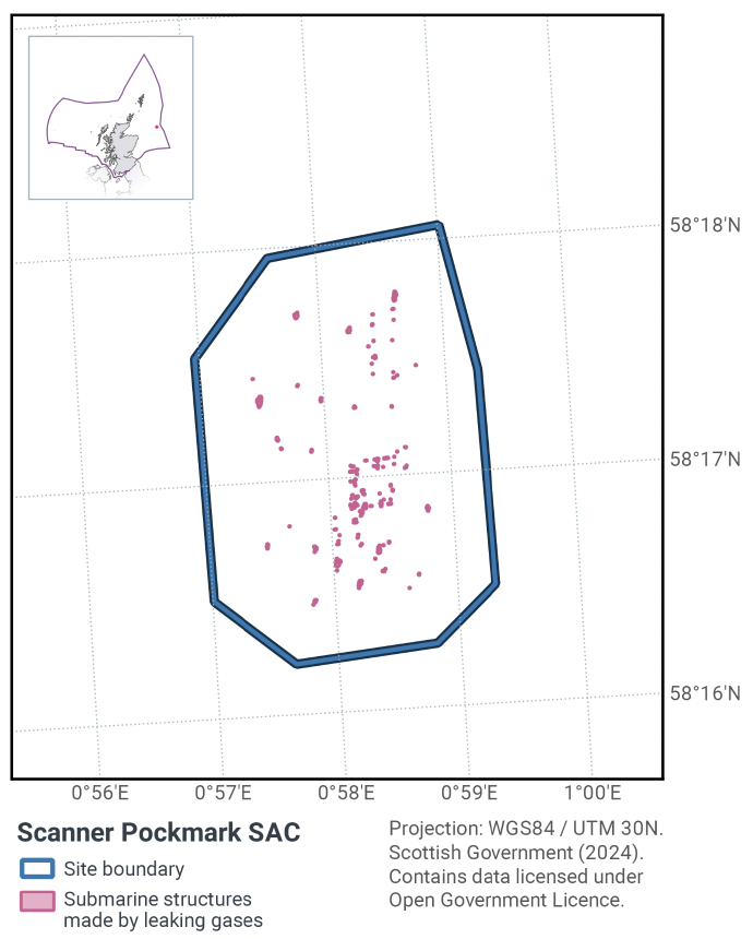
The Scanner Pockmark SAC is located in the Northern North Sea Regional, approximately 185km off the north-east coast of Scotland near the centre of the Witch Ground Basin (Figure 1). The Scanner pockmark itself, together with additional pockmark depressions, make up the Scanner Pockmark SAC. A total of 67 pockmarks have been identified within the site boundary. The pockmarks were created by the expulsion of fluids and have been maintained by active gas seepage.
The Scanner pockmark complex in the south of the site is a large seabed depression of approximately 320,000 m2 containing two deep areas about 17 meters below the surrounding seafloor. Carbonate blocks known as 'Submarine structures made by leaking gases' form when methane is released from the seabed and reacts with the surrounding seawater and have been recorded in the base of these pockmarks. The northern section of the site contains the Scotia pockmark complex with two deep sections and active methane seeps. These large pockmarks reach a depth of approximately 15 meters below the surrounding sea floor.
The pockmark contains large blocks of the Annex I habitat “Submarine structures made by leaking gases”, for which the site is designated. These carbonate blocks lie in the base of the pockmark and support fauna more typically associated with rocky reef, as well as highly specific chemosynthetic micro-organisms, which feed on discharged methane and its by-product, hydrogen sulphide.
The Conservation Objectives for the Annex I habitats Submarine structures made by leading gases at Scanner Pockmarks are:
Subject to natural change, maintain or restore the Annex I habitat Submarine structures made by leaking gases to ‘Favourable Condition’, such that:
- the extent and distribution of the qualifying habitat in the site;
- the structure and function of the qualifying habitat in the site;
- the supporting processes on which the qualifying habitat relies
are maintained or restored, thereby ending the integrity of the site and also making an appropriate contribution to favourable condition status of Annex I habitats (see the Scanner Pockmark SAC: Relevant Documentation & Conservation Advice 2018). The feature condition has been assessed by JNCC as being ‘Unfavourable’, although it should be noted that it is not considered feasible to restore some of the feature’s attributes using management intervention.
More information regarding the designation of the Scanner Pockmark SAC is available in the Standard Data Form.
More information regarding the conservation objectives for the protected feature of Scanner Pockmark SAC is available within the site’s conservation advice package available on JNCC’s site information centre.
1.3 Activities assessed
The process followed to conduct this ‘Fisheries Assessment’ is in line with the process for a Habitats Regulation Appraisal, as required under Article 6(3) of Council Directive 92/43/EEC of 21 May 1992 on the conservation of natural habitats and of wild fauna and flora (the Habitats Directive); for sites within the offshore region under Regulation 28 of the Conservation of Offshore Marine Habitats and Species Regulations 2017.
In this context, fishing activity within the SAC is considered to be the plan or project, and the implications of fishing activity in view of the conservation objectives for the SAC are being assessed through the fisheries screening stage (Part A), the fisheries assessment (Part B), Fisheries assessments use the best available evidence to fully consider potential impacts of commercial fishing activity, and in-combination (cumulative) effects with other plans and projects, against the conservation objectives for the site. If the assessment concludes that use of certain fishing gear types is not compatible with the conservation objectives of the site, management measures will be considered.
Commercial sea fishing activity has the potential to vary in nature and intensity over time. This assessment considers fishing activity based on activity levels and type between 2015-2019. This date range was considered to provide the best available data on current fishing activity levels for the assessment. Using a five year date range provides an average view of fishing activity within the site; latter years (2020 – 2021) were not considered representative of regular fishing activity due to the Covid pandemic. The selected date range (2015 – 2019) was used consistently across all assessments within the consultation package. Changes in fishing activity after this time period may be considered in future reviews of this assessment (see Section 6).
Contact
Email: marine_biodiversity@gov.scot
There is a problem
Thanks for your feedback