Draft Fisheries Assessment – Scanner Pockmark SAC: Fisheries management measures within Scottish Offshore Marine Protected Areas (MPAs)
These assessments look at the fishing activity occurring within each offshore MPA and SAC and assess the potential impacts of this activity on the protected features within each site. This assessment is for Scanner Pockmark SAC.
3. Part B Assessment – Fisheries Assessment
3.1 Fisheries assessment overview
Part B of this assessment meets the requirements for an appropriate assessment under Article 6(3) of Council Directive 92/43/EEC of 21 May 1992 on the conservation of natural habitats and of wild fauna and flora (the Habitats Directive) and Regulation 28 of the Conservation of Offshore Marine Habitats and Species Regulations 2017.
The fishing activities and pressures identified in Part A, at the levels identified in the relevant date range, which have been included for assessment in Part B, is demersal trawl fishing activity. The only pressures associated with these fishing activities that have been included in Part B are:
- abrasion/disturbance of the substrate on the surface of the seabed,
- penetration and/or disturbance of the substrate below the surface of the seabed, including abrasion,
- removal of non-target species,
- smothering and siltation rate changes (Light) and
- changes in suspended solids (water clarity).
3.2 Fishing Activity Descriptions
3.2..1 Existing management of fishing activity within Scanner Pockmark SAC
No existing fisheries restrictions were identified for the site.
3.2..2 Fishing activity within Scanner Pockmark SAC
The Scanner Pockmark SAC lays within ICES rectangle 45F0 in the Northern North Sea (ICES Division 4a), in the Fladen region. The main gear types for UK vessels are demersal and midwater trawls, predominantly targeting Nephrops, herring and monk/anglerfish.
VMS-based estimates and ICES rectangle landings statistics indicate that over-12 m demersal trawls and midwater trawls are the predominant UK vessels that operated within the site over the period 2015-2019.
For the over-12 m vessels, based on VMS data from 2015-2019, demersal trawls operate throughout the site with a relatively even distribution. Midwater trawl activity was recorded at one location in the north eastern part of the site.
In addition to UK activity, vessels from Denmark (5 vessels), Norway, Sweden and Netherlands (number of vessels cannot be disclosed) may also operate in the site, based on VMS data from 2015-2019. However, it is unclear what gear types these vessels operate, nor whether they were actively fishing at the time.
3.2..3 Demersal Trawls
The aggregated gear method of demersal trawls includes multiple gears that operated within the Scanner Pockmark SAC between 2015 and 2019. These include bottom otter trawl, multi-rig trawls and Nephrops trawls (Table 2). The target species for these gear types are demersal fish or Nephrops. Similar pressures are exerted by the different gears used for demersal trawling, subsequently the aggregated gear type of ‘demersal trawl’ was used to map activity across the site.
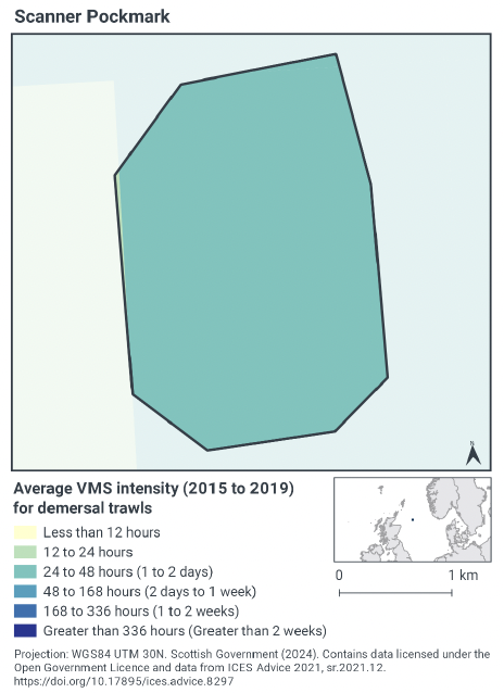
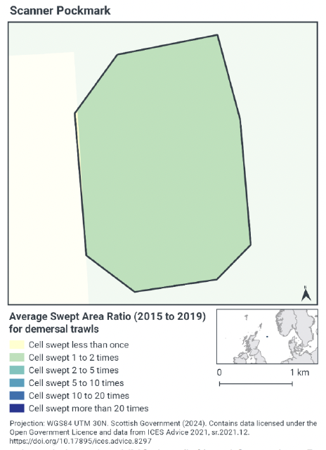
According to VMS intensity averaged over 2015 to 2019, demersal trawling activity occurs throughout the site (Figure 2), with 24 - 48 fishing hours occurring within the site per year per grid cell.
Swept-Area Ratio (SAR) information averaged over the same time period shows similar patterns of fishing intensity as the VMS data (Figure 2), with cells being swept 1 – 2 times per year per grid cell.
3.2..4 Fishing activity summary
The most common fishing activity within Scanner Pockmark SAC is demersal trawling. The protected feature, Submarine structures made by leaking gases, is distributed throughout Scanner Pockmark SAC, and the fishing activity is also distributed across the whole site.
3.3 Fishing activity effects overview
The following sections explore the impacts associated with fishing activity (demersal trawls) within the Scanner Pockmark SAC that were identified as potentially having likely significant effects on the Submarine structures made by leaking gases feature. The pressures considered in the following sections are:
- Abrasion/disturbance of the substrate on the surface of the seabed;
- Penetration and/or disturbance of the substrate below the surface of the seabed, including abrasion;
- Changes in suspended solids (water clarity);
- Smothering and siltation rate changes (light); and
- Removal of non-target species.
Given the similarity between ‘abrasion/disturbance of the substrate on the surface of the seabed’ and ‘penetration and/or disturbance of the substrate below the surface of the seabed’, these two pressures are considered together in the text below. ‘Smothering and siltation rate changes (light)’ and ‘changes in suspended solids (water clarity)’ are also considered together. All pressures with the potential for likely significant effects are discussed under the aggregated fishing gear type of ‘mobile demersal trawling’.
The detailed pressure information for this section is based on the Advice on Operations for Scanner Pockmark SAC, the Feature Activity Sensitivity Tool (FeAST), and the site summary document within the consultation package.
3.3..1 Impacts of mobile demersal gears (trawls) on the pockmarks geodiversity feature on which the Submarine structures made by leaking gases are dependent
Consideration of exposure to and the effect of a pressure on submarine structures formed by leaking gases feature within the Scanner Pockmark SAC includes the consideration of exposure to and the effect of that pressure on any ecological or geomorphological process on which the conservation of the protected feature is wholly or in part dependant. In this light, consideration is also given to the sensitivity of the pockmarks geodiversity feature to mobile demersal trawls, particularly as infilling for some pockmarks within the site obscured carbonate structures and bacterial mats previously recorded in 1985 and 1990 (JNCC, 2020).
According to FeAST, pockmarks are formed by the expulsion of fluids from the seabed, typically in a single event which fluidises the sediment and lifts it into the water column. This event will have occurred at some point in the past: present day gas seepage observed in many pockmarks is generally no more than a gentle bubble which is insufficient to erode the seabed sediments (Judd, 2001). Accordingly, FeAST considered the resilience of pockmarks to surface and subsurface abrasion/penetration as ‘none’ as the feature has little or no capacity to regenerate. Where the pressure is confined to the surface of the feature alone, the feature resistance to surface abrasion is considered to be high. Where sub-surface abrasion/penetration occurs, because pockmarks are likely to comprise of soft, erodible silty clays, the feature resistance is considered to be medium. Overall, pockmarks have low sensitivity to surface abrasion and medium sensitivity to sub-surface abrasion/penetration. Pockmarks are not sensitive to changes in suspended solids (water clarity) and the pressure smothering and siltation rate changes (light) is not relevant for pockmarks as geodiversity features. Removal of non-target species is not relevant for pockmarks, which are geodiversity features. In terms of other pressures exerted by mobile demersal trawls, pockmarks are not sensitive to physical change (to another seabed type) or physical change (to another sediment type) and the remaining pressures associated with mobile demersal trawls are not relevant to geodiversity features, such as pockmarks.
3.3..2 Impacts of mobile demersal gears (trawls) on submarine structures made by leaking gases
As detailed in the Advice on Operations for Scanner Pockmark SAC, abrasion/disturbance of the substrate on the surface of the seabed and penetration and/or disturbance of the substrate below the surface of the seabed, including abrasion, occur where gear makes contact with the seafloor. The area affected is determined by the footprint of the gear and the amount of movement across the seabed. The different gear components will make variable contributions to the total physical disturbance of the seabed and its associated biota, and hence the pressure will vary according to factors such as gear type, design/modifications, size and weight, method of operation (including towing speed) and habitat characteristics (e.g. topography) (Lart, 2012; Polet & Depestele, 2010; Suuronen et al., 2012). Towed bottom fishing gears are used to catch species that live in, on or in association with the seabed and therefore are designed to remain in close contact with the seabed. That interaction with the seabed can lead to disturbance of the upper layers of the seabed, direct removal, damage, displacement or death of the benthic flora and fauna; short-term attraction of scavengers; and the alteration of habitat structure (Kaiser et al., 2003; Gubbay & Knapman, 1999; Sewell & Hiscock, 2005; Collie et al., 2000; Kaiser et al., 2002).
As a relative comparison of gear types, otter trawls tend to have less physical impact on the seafloor than beam trawls (and dredges) with their heavy tickler chains, although the doors of an otter trawl do create recognisable scour of the seabed (Hinz et al., 2012; Polet & Depestele, 2010; Lart, 2012; Paschen et al. 2000). The magnitude of the immediate response to fishing disturbance, cumulative effects and recovery times varies significantly according to factors such as the type of fishing gear and fishing intensity, the habitat and sediment type, and levels of natural disturbance and among different taxa (Collie et al., 2000; Boulcott et al., 2014; Kaiser et al., 2006; Hinz et al., 2009; Kaiser et al., 2001).
Bycatch (i.e. discarded catch) is associated with almost all fishing activities and is related to factors such as gear type and its design (i.e. its selectivity), the target species and effort. There are significant concerns over the impacts of discards on marine ecosystems including changes in population abundance and demographics of affected species and altered species assemblages and food web structures (Alverson et al., 1994; Kaiser et al, 2001). Mixed-species and shrimp/prawn demersal trawl fisheries are associated with the highest rates of discarding and pose the most complex problems to resolve (Alverson et al., 1994; Feekings et al., 2012; Catchpole et al., 2005). Benthic trawls most frequently result in bycatch of fish crustaceans and other invertebrates and less frequently turtles and birds (Gubbay & Knapman, 1999; Sewell & Hiscock, 2005; ICES, 2013; Pierpoint, 2000; Bergmann & Moore, 2001; Catchpole et al., 2005; Tulp et al., 2005).
Changes in suspended solids (water quality) and siltation rate changes (light), including smothering, may result from physical disturbance of the sediment, along with hydrodynamic action caused by the passage of towed gear, leading to entrainment and suspension of the substrate behind and around the gear components and subsequent siltation (Sewell et al., 2007; Gubbay & Knapman, 1999; Lart, 2012; Kaiser et al., 2002; Riemann & Hoffmann, 1991; O’Neill et al., 2008; Dale et al., 2011; O’Neill & Summerbell, 2011). The quantity of suspended material, its spatial and temporal persistence and subsequent patterns of deposition will depend on factors associated with the gear (such as type/design, weight, towing speed), sediment (particle size, composition, compactness), the intensity of the activity, and the background hydrographic conditions (Sewell et al., 2007; Connor et al., 2004; Dale et al., 2011; O’Neill et al., 2008). Turbid plumes can reduce light levels and smother feeding and respiratory organs. Sediment remobilisation and deposition can affect the settlement, feeding, and survival of biota through smothering of feeding and respiratory organs. Prolonged exposure of an area to these pressures may result in changes in sediment composition, including through suspension and transport of finer material. There are also concerns over resuspension of phytoplankton cysts and copepod eggs (Kaiser et al., 2001; Sewell et al., 2007; Gubbay & Knapman, 1999; Kaiser et al., 2002; O’Neill & Summerbell, 2011).
Direct evidence of impacts of demersal mobile gears (trawls) to submarine structures made by leaking gasses or to the pockmarks feature on which the submarine structures are dependent is limited. However, the biological communities that develop on exposed structures formed by the leaking gases typically include many of the same species that can be found on subtidal rocky habitats in similar environmental conditions, and it is likely that the effects of fishing will be similar.
The use of demersal mobile fishing gears is likely to cause damage or death of fragile, erect species, such as sponges and corals (Freese et al., 1999; Løkkeborg, 2005). Other species such as hydroids, anemones, bryozoans, tunicates and echinoderms are vulnerable to mobile fishing gear (McConnaughey et al., 2000; Sewell & Hiscock, 2005). Recovery is likely to be slow (Foden et al., 2010). Where fragile, slow growing species occur, even low levels of fishing have the potential to change the structure and function of the habitats and may result in the loss of some characteristic species.
VMS data shows that moderate levels of mobile demersal trawling take place across Scanner Pockmark SAC.
Given the evidence above the impacts of abrasion/disturbance of the substrate on the surface of the seabed, penetration and/or disturbance of the substrate below the surface of the seabed, including abrasion, removal of non-target species, smothering and siltation rate changes (light), and changes in suspended solids (water clarity) from demersal trawling alone within Scanner Pockmark SAC at current levels of activity have the potential to affect the conservation objectives to maintain or restore the submarine features made by leaking gases, such that the extent and distribution, structure and function and supporting processes are maintained or restored. Accordingly, Scottish Ministers conclude that demersal trawls alone are not compatible with the conservation objectives of the site and may result in an adverse effect on site integrity at current levels of activity.
3.4 Part B conclusion
The assessment of fishing pressures on Annex I Submarine structures made by leaking gases in Scanner Pockmark SAC has shown that an adverse effect on site integrity cannot be ruled out where demersal trawling activities occur. At present, no other types of demersal fishing activities are known to take place within Scanner Pockmark SAC. As such, Scottish Ministers concludes that management measures to restrict these mobile demersal gear would be required within Scanner Pockmark SAC to ensure site integrity. Section 5 contains further details on potential measures.
Contact
Email: marine_biodiversity@gov.scot
There is a problem
Thanks for your feedback