Draft Fisheries Assessment – Solan Bank Reef SAC: Fisheries management measures within Scottish Offshore Marine Protected Areas (MPAs)
These assessments look at the fishing activity occurring within each offshore MPA and SAC and assess the potential impacts of this activity on the protected features within each site. This assessment is for Solan Bank Reef SAC.
1 Introduction
1.1 Scope of the Solan Bank Reef SAC assessment
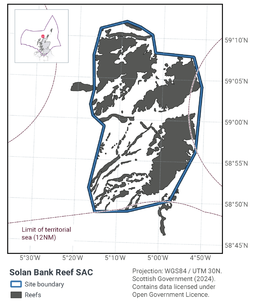
The geographic scope of this assessment covers the whole of the Solan Bank Reef SAC, including portions within both the offshore (12 – 200 nautical miles, nm) and inshore (0 – 12 nm) regions (Figure 1). The purpose of this assessment is to determine whether the current levels of fishing activity occurring within the site are compatible with the conservation objectives of the Solan Bank Reef SAC and to identify options for management measures.
In this assessment, Scottish Ministers use the best available evidence to review the site characteristics and current fishing activity (Part A), both taken alone and in combination with other relevant activities (Part C), to determine if there is the potential for these activities to have a likely significant effect (LSE) on the protected feature of the site (Annex I Reef). Any fishing activities with the potential for LSE, either alone or in combination with other relevant activities are considered further to assess whether they could result in an adverse effect on site integrity (Part B).
Where there is the potential for an adverse effect on site integrity, management measures are identified for the site by Scottish Ministers. These measures are considered in light of the conservation objectives, biological characteristics, current activity levels, and existing fisheries restrictions for Solan Bank Reef SAC.
A final decision on which measures, if any, are to be adopted will follow upon a statutory consultation exercise and will take into account all relevant statutory obligations incumbent upon Scottish Ministers.
A methodology document has been prepared to aid understanding of these assessments.
1.2 Site description
Solan Bank Reef SAC (Figure 1) is located approximately 50 km from the Scottish mainland, north of Cape Wrath. The reef is located on the Solan Bank High, a Precambrian geological feature of metamorphic basement rock 130 km long and 25 km wide with sections of sand and clay. The site is surrounded by the North Rona, North Lewis, North Minch and West Orkney basins and between the East Rona High to the west and Nun Rock-Sule Skerry High to the east. The majority of the site lies in water depths of 60–80 m. However, to the south-east of the site an outcrop of bedrock reef rises to approximately 20 m below the sea surface, while the north of the site extends to more than 90 m water depth. The site lies across the 12 nm territorial sea limit. Advice on this SAC is therefore jointly delivered by the Joint Nature Conservation Committee (JNCC) and Scottish Natural Heritage (operating name of and hereinafter referred to as NatureScot).
The site represents the Annex I reef sub-types 'bedrock' and 'stony' reef (Table 1; Figure 1). Bedrock outcrops create areas of high topography, with linear features (thought to be bedrock joint planes) forming cliffs of up to 10 m in height above the surrounding seabed. Elsewhere the bedrock forms smooth and undulating features known as roches moutonnées, created by the scour effect of moving glacial ice. Stony reef comprised of boulders and cobbles with a sandy veneer occurs in ridges to the north-west and south-west of the site; these most likely represent glacial moraine ridges (the tracks of sediment carried by glacial ice). Boulders and cobbles also occur in the larger crevices in the bedrock while smaller rock fissures are filled with a mixture of coarse sand and shell/gravel veneer.
The reefs are characterised by encrusting fauna, mainly encrusting bryozoans and encrusting coralline algae in the shallower areas. Cup corals are present throughout the site, and brittlestars are common on both the bedrock and stony reef. Areas of flatter bedrock subject to sediment scour have a lower diversity of fauna than more sheltered areas. The highly scoured reef is mainly colonised by the keel worm Spirobranchus triqueter, while a range of sponges, bryozoans and hydroids occur on less scoured reef areas. Water movement created by tidal streams and wave action is greater in shallower areas and here there is a higher abundance of species such as the soft coral Alcyonium digitatum, the cup coral Caryophyllia (Caryophyllia) smithii and the jewel anemone Corynactis viridis. Foliose red algae and kelp grow in the shallowest locations where there is sufficient light penetration.
The Solan Bank Reef SAC provides geographic representation of the Annex I reef habitat in Scottish seas, and is one of eight SACs hosting this feature in Scottish seas. The Solan Bank Reef SAC is located near the border of OSPAR Region II & III, within which there are 29 protected areas for this feature (Celtic III Seas: 24; Greater North Sea II: 5).
The Conservation Objectives for the Annex I Reef at Solan Bank Reef are:
Subject to natural change, maintain or restore the reef in/to favourable condition, such that:
- the natural environmental quality and processes supporting the habitat
- the extent of the habitat on site
- the physical structure, community structure, function, diversity and distribution of the habitat and typical species representative of the reef in the Northern North Sea regional sea
are maintained or restored, thereby ensuring the integrity of the site and also making an appropriate contribution to favourable conservation status of the Annex 1 habitats (see ‘Conservation Objectives and Advice on Operations (2013)’ in the Solan Bank Reef MPA: Relevant Documentation & Conservation Advice 2012).
The condition of the reef feature at Solan Bank Reef SAC is uncertain, resulting from a lack of detailed information on levels of exposure to human activities and their ecological impact on the feature at this site. Further information will be required to assess and monitor favourable condition of the reef feature at this offshore region SAC. There is no direct evidence to date that the feature has been damaged by human activities (as at 2012), however best available evidence indicates that demersal fishing occurs over the reef feature, exposing it to pressures to which it is sensitive and subsequently it is assessed as moderately vulnerable. Although it is likely that bottom trawlers avoid the hard substrate to prevent damage to their gear, according to the NatureScot and JNCC Conservation Objectives and Advice on Operations, the best available evidence (as at 2012) was not of sufficient spatial resolution to confirm this and so the objective was set to maintain or restore.
More information regarding the conservation objectives for the protected features of Solan Bank Reef SAC is available in the NatureScot and JNCC Conservation Objectives and Advice on Operations for the site.
| Reef type | Habitat area within SAC (km2) |
|---|---|
| Deep circalittoral bedrock reef | 295.1 |
| Infralittoral bedrock reef | 0.4 |
| Shallow circalittoral bedrock reef | 29.3 |
| Stony reef | 60.3 |
| Total | 385.1 |
1.3 Activities assessed
The process followed to conduct this ‘Fisheries Assessment’ is in line with the process for a Habitats Regulation Appraisal, as required under Article 6(3) of Council Directive 92/43/EEC of 21 May 1992 on the conservation of natural habitats and of wild fauna and flora (the Habitats Directive); for sites within the offshore region under Regulation 28 of the Conservation of Offshore Marine Habitats and Species Regulations 2017; and for sites within the inshore region under Regulation 48(1) of the Conservation (Natural Habitats, & c.) Regulations 1994.
In this context, fishing activity within the SAC is considered to be the plan or project, and the implications of the fishing activity in view of the conservation objectives for the SAC are being assessed through the fisheries screening stage (Part A), the fisheries assessment (Part B), and the in combination (cumulative effect) assessment (Part C).
Fisheries assessments use the best available evidence to fully consider potential impacts of commercial fishing activity, and in-combination (cumulative) effects with other plans and projects, against the conservation objectives for the site. If the assessment concludes that use of certain fishing gear types is not compatible with the conservation objectives of the site, management measures will be considered.
Commercial sea fishing activity has the potential to vary in nature and intensity over time. This assessment considers fishing activity based on activity levels and type between 2015-2019. This date range was considered to provide the best available data on current fishing activity levels for the assessment. Using a five year date range provides an average view of fishing activity within the site; latter years (2020 – 2021) were not considered representative of regular fishing activity due to the Covid pandemic. The selected date range (2015 – 2019) was used consistently across all assessments within the consultation package. Changes in fishing activity after this time period may be considered in future reviews of this assessment (see Section 6).
Contact
Email: marine_biodiversity@gov.scot
There is a problem
Thanks for your feedback