Draft Fisheries Assessment – Stanton Bank Reef SAC: Fisheries management measures within Scottish Offshore Marine Protected Areas (MPAs)
These assessments look at the fishing activity occurring within each offshore MPA and SAC and assess the potential impacts of this activity on the protected features within each site. This assessment is for Stanton Bank Reef SAC.
1 Introduction
1.1 Scope of the Stanton Bank SAC assessment
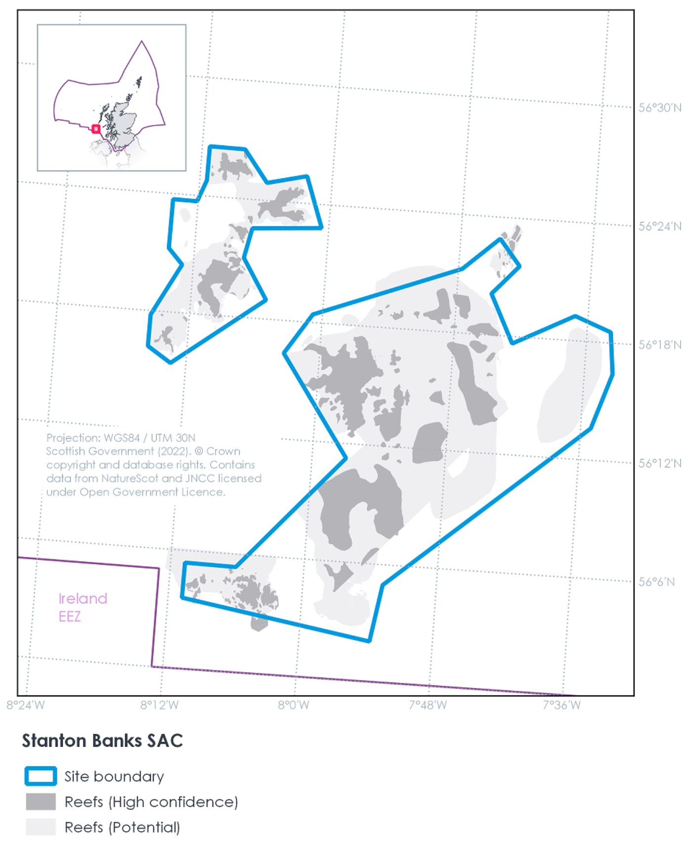
The geographic scope of this assessment covers the whole of the Stanton Bank SAC, located in the Scottish offshore (Figure 1). The purpose of this assessment is to determine whether the current levels of fishing activity occurring within the site are compatible with the conservation objectives of the Stanton Bank SAC and to identify options for management measures.
In this assessment, Scottish Ministers use the best available evidence to review the site characteristics and current fishing activity (Part A), both taken alone and in combination with other relevant activities (Part C) to determine if there is the potential for these activities to have a likely significant effect (LSE) on the protected feature of the site (Annex I Reef). Any fishing activities with the potential for LSE, either alone or in combination with other relevant activities, are considered further to assess whether they could result in an adverse effect on site integrity (Part B).
Where there is potential for an adverse effect on site integrity, management measures are identified for the site by Scottish Ministers. These measures are considered in light of the conservation objectives, biological characteristics of the protected features, current activity levels, and existing fisheries restrictions for Stanton Bank SAC. A final decision on which measures, if any, are to be adopted, will follow upon a statutory consultation exercise and will take into account all relevant statutory obligations incumbent upon Scottish Ministers.
A methodology document has been prepared to aid understanding of these draft assessments.
1.2 Site description
Stanton Banks SAC (Figure 1) is located in the Scottish Continental Shelf south of the Outer Hebrides and lies approximately 124 km west of the UK mainland, 43 km west-south-west of Tiree and 83 km north-north-east of Malin Head, Ireland.
The site represents the Annex I reef sub-types 'bedrock' and 'stony' reef (Table 1; Figure 1). Surveys of the Stanton Banks reef has shown it to be a rocky landscape with deep gullies. Although the rocky outcrops have been rounded by glacial action, they remain deeply fissured and extremely rugged. The rocky outcrops rise from the seabed at 190 m below sea-level to approximately 30 m below sea-level, encompassing a vertical rise of approximately 160 m. The major gullies within the site are approximately 100 m wide and up to 30 m deep, with other minor gullies typically measuring 20–40 m wide.
The bedrock outcrops are heavily encrusted with coralline algae, keel worms and brittlestars such as Ophiura albida, with clusters of sponges including cup-shaped axinellid sponges (Axinella infundibuliformis). On the slopes, there is a transition from smooth bedrock to fissured rock outcrops, boulder and cobble with feather stars (Leptometra celtica), dead man's fingers (Alcyonium digitatum) and robust hydroids (Tubularia spp.). The lower circalittoral zone of the Stanton Banks is characterised by smooth, silty bedrock dominated by extensive encrusting coralline red algae, numerous barnacles, brittlestars, small sponge crusts (including Hymedesmia (Hymedesmia) paupertas), cup-shaped axinellid sponges (A. infundibuliformis) and massive sponges (Mycale (Mycale) lingua and Pachymatisma johnstonia). Starfish (such as Luidia ciliaris, Porania (Porania) pulvillus, Crossaster papposus) and sea urchins (Echinus esculentus) are also common.
Surrounding the Annex 1 rocky reef feature, the banks are fringed with stony reef comprising of boulders and cobbles, graduating into coarse and mixed sediments. Many of the cobbles are covered by encrusting sponges (including H. paupertas), hydroids and bryozoans. Crabs (Cancer pagurus) and squat lobsters (Galatheoidea sp.) are also present. There have been reports of cold-water coral at the site, but JNCC documentation on Stanton Bank has no direct evidence to support this.
The Stanton Bank SAC provides geographic representation of the Annex I reef habitat in Scottish seas, and is one of eight SACs hosting this feature in Scottish seas. The Stanton Bank SAC is located in the OSPAR Celtic Seas Region III, within which there are 24 protected areas for this feature.
The conservation objectives for the Stanton Banks SAC are:
For the feature to be in favourable condition thus ensuring site integrity in the long term and contribution to Favourable Conservation Status of Annex I Reefs.
This contribution would be achieved by maintaining or restoring, subject to natural change:
- The extent and distribution of the qualifying habitat in the site;
- The structure and function of the qualifying habitat in the site; and
- The supporting processed on which the qualifying habitat relies.
The condition of the reef feature at Stanton Banks SAC has been assessed by JNCC as unfavourable. Thus, the reef feature needs to be restored to favourable condition. More information on the condition of the reef feature and conservation objectives of Stanton Banks SAC is available in the Stanton Banks MPA – Conservation Advice 2018.
| Reef type | Habitat area within SAC (km2) |
|---|---|
| Bedrock | 160.31 |
| Bedrock and/or stony | 317.47 |
| Stony reef | 74.59 |
| Total | 552.37 |
1.3 Activities assessed
The process followed to conduct this ‘Fisheries Assessment’ is in line with the process for a Habitats Regulation Appraisal, as required under Article 6(3) of Council Directive 92/43/EEC of 21 May 1992 on the conservation of natural habitats and of wild fauna and flora (the Habitats Directive) and for sites within the offshore region under Regulation 28 of the Conservation of Offshore Marine Habitats and Species Regulations 2017.
In this context, fishing activity within the SAC is considered to be the plan or project, and the implications of the fishing activity in view of the conservation objectives for the SAC are being assessed through the fisheries screening stage (Part A), the fisheries assessment (Part B), and the in combination (cumulative effect) assessment (Part C).
Fisheries assessments use the best available evidence to fully consider potential impacts of commercial fishing activity, and in-combination (cumulative) effects with other plans and projects, against the conservation objectives for the site. If the assessment concludes that use of certain fishing gear types is not compatible with the conservation objectives of the site, management measures will be considered.
Commercial sea fishing activity has the potential to vary in nature and intensity over time. This assessment considers fishing activity based on activity levels and type between 2015-2019. This date range was considered to provide the best available data on current fishing activity levels for the assessment. Using a five year date range provides an average view of fishing activity within the site; latter years (2020 – 2021) were not considered representative of regular fishing activity due to the Covid pandemic. The selected date range (2015 – 2019) was used consistently across all assessments within the consultation package. Changes in fishing activity after this time period may be considered in future reviews of this assessment (see Section 6).
Contact
Email: marine_biodiversity@gov.scot
There is a problem
Thanks for your feedback