Draft Fisheries Assessment – Turbot Bank NCMPA: Fisheries management measures within Scottish Offshore Marine Protected Areas (MPAs)
These assessments look at the fishing activity occurring within each offshore MPA and SAC and assess the potential impacts of this activity on the protected features within each site. This assessment is for Turbot Bank NCMPA.
3. Part B – Fisheries Assessment
3.1 Fisheries assessment overview
Part B of this assessment considers if there would be a risk of the fishing activities identified in Part A, at the levels identified in the relevant date range, hindering the achievement of the conservation objectives for the NCMPA, in order to consider whether, and if so, which, management measures might be appropriate for the MPA, taking into account all relevant statutory obligations incumbent upon the Scottish Ministers.
The fishing activities and pressures identified in Part A which have been included for assessment in Part B, are demersal trawls, demersal seines and boat dredge and the pressures abrasion/disturbance of the substrate on the surface of the seabed; penetration and/or disturbance of the substrate below the surface of the seabed, including abrasion; changes in suspended solids (water clarity); and smothering and siltation rate changes (light).
3.2 Fishing activity descriptions
3.2.1 Existing management of fishing activity within the Turbot Bank NCMPA
The NCMPA sits within the sandeel Area 4 management unit for which there was a very limited Total Allowable Catch for sandeel. In addition, a small area to the west of the NCMPA overlaps with the East of UK sandeel closure area which was introduced to prevent localised depletion of sandeel (Article 29a Council Regulation (EC) No 227/2013). A reduced fishery for scientific investigation is permitted within the closed area although this option has not been taken up in recent years.
The Scottish Government has prohibited fishing for sandeel in all Scottish waters. The Sandeel (Prohibition of Fishing) (Scotland) Order 2024 came into force on 26 March 2024 ahead of the 2024 fishery season and will apply to all vessels (UK and EU) fishing within Scottish waters.
3.2.2 Fishing Activity within the MPA
The Turbot Bank NCMPA overlaps ICES rectangles 43E8 and 43E9 and sits within ICES Division 4b. VMS-based estimates and ICES rectangle landings statistics indicate that vessels utilising boat dredges are the predominant UK vessels that operated within the site over the period 2015-2019.
A bottom trawl fishery for haddock and associated whitefish is widespread throughout the NCMPA together with a lower intensity Scottish seine (fly-shooting) whitefish fishery. Although landings from both fisheries have fluctuated over the years, it is clear that they are longstanding fisheries. A significant scallop dredge fishery occurs in the vicinity of the MPA.
For the over-12 m vessels, based on VMS data from 2015-2019, boat dredge operated across the majority of the site. Demersal trawl and demersal seine also occurred at lower levels, also utilising the majority of the site.
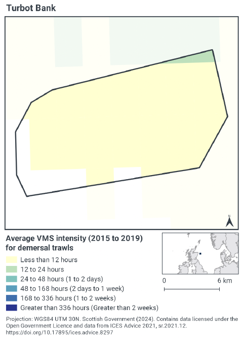
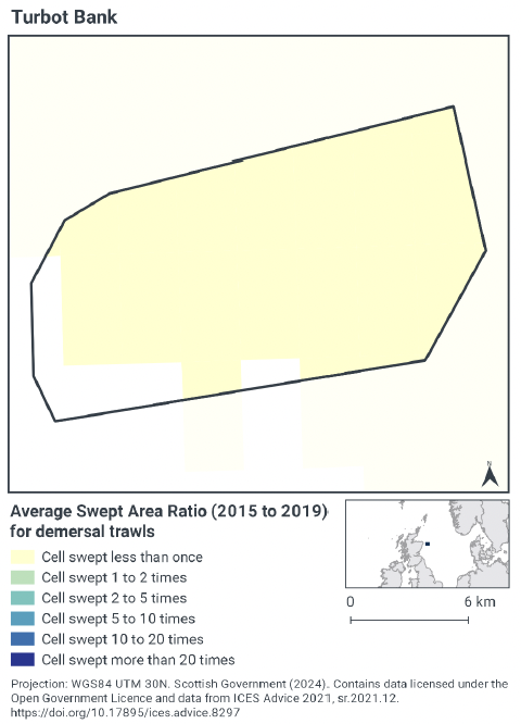
3.2.3 Demersal Trawls
The aggregated gear method of demersal trawls includes the multiple gears (OTB, OTT, PTB and TB) that operated within the Turbot Bank NCMPA between 2015 and 2019. These include bottom otter trawls, multi-rig trawls, pair trawls, and other not specified bottom trawl types (Table 1).
The target species for these gear types are demersal fish, nephrops and molluscs. Similar pressures are exerted by the different gears used for demersal trawling, subsequently the aggregated gear type of ‘demersal trawl’ was used to map activity across the site.
Based on the VMS, demersal trawl activity occurred at less than 12 hours of activity per year per grid cell (averaged 2015-2019). The north-east corner showed a partial square within the site with a higher value of 12 to 24 hours per year per grid cell.
Swept-Area Ratio (SAR) information averaged over the same time period shows similar patterns of fishing intensity as the VMS data (Figure 2) with the majority of the site showing as being swept, and at a value off less than once per year per grid cell between 2015-2019.
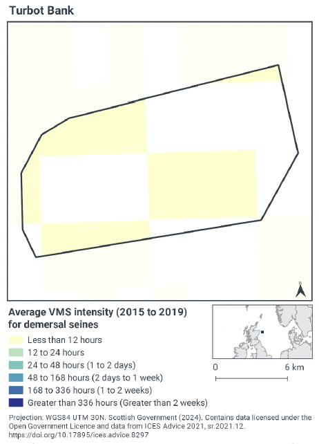
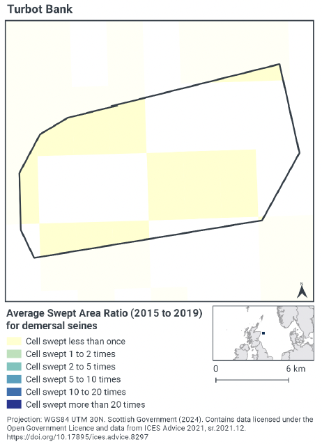
3.2.4 Demersal Seines
Scottish Seines were found to operate within the Turbot Bank NCMPA between 2015 and 2019 (Table 1). These seines target demersal fish.
Based on the VMS, demersal seine activity within Turbot Bank NCMPA occurred in the west and central region of the site up to a maximum of 12 hours per year per grid cell (Figure 3).
Swept-Area Ratio (SAR) information averaged over the same time period shows similar patterns of fishing intensity as the VMS data (Figure 3), with areas of low fishing intensity dispersed throughout the site, which were swept less than once per year per grid between 2015-2019.
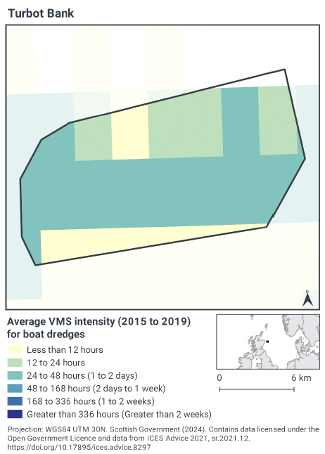
3.2.5 Boat Dredge
Fishing with the gear type towed dredge was identified during activity screening as an activity occurring within the site during the assessment period (2015-2019). Vessels utilising this gear were shown to target mollusc species.
The VMS data (Figure 4) showed that the majority of dredge activity occurred in central a lateral band across the site and at a lower level to the north. The central region shows activity occurring at 24 – 48 hours per year per grid cell, and at a lower level of less than 24 hours per year per grid cell in the northern area of the site.
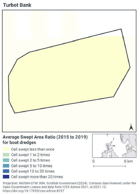
SAR information averaged over the same time period shows an equal distribution of all cells being sept less than once across the full site.
3.2.6 Summary of fishing activity within Turbot Bank MPA
Fishing activities using demersal trawls, demersal seines and boat dredge all occur within Turbot Bank MPA. The majority of this fishing activity within the site is undertaken by boat dredge across central portions of the site on average 1-2 days per year. Demersal trawl activity predominantly occurred at low levels across the full site, and demersal seines occurring with a scattered distribution at a low level.
3.3 Fishing activity effects overview
The following sections explore the pressures associated with fishing activity (demersal trawls, demersal seines, and boat dredge) within the Turbot Bank NCMPA that were considered capable of impacting the sandeel feature. The pressures considered in the following sections are:
- Abrasion/disturbance of the substrate on the surface of the seabed;
- Penetration and/or disturbance of the substrate below the surface of the seabed, including abrasion;
- Changes in suspended solids (water clarity); and
- Smothering and siltation rate changes (light).
All four pressures, as exerted by mobile demersal fishing (trawls, seines and boat dredges), were considered capable of impacting the sandeel feature.
Given the similarity between ‘abrasion/disturbance of the substrate on the surface of the seabed’ and ‘penetration and/or disturbance of the substrate below the surface of the seabed’, these two pressures are considered together in the text below. ‘Smothering and siltation rate changes (light)’ and ‘changes in suspended solids (water clarity)’ are also considered together. All pressures considered capable of impacting are discussed under the aggregated fishing gear types of ‘mobile demersal gears’.
In the absence of a detailed JNCC Advice on Operations spreadsheet for this site, the detailed pressure information for this section is based on information from the Management Options paper for Turbot Bank MPA, JNCC PAD and FeAST and JNCC and NatureScot Fisheries Management Guidance document for Sandeels.
3.3.1 Impacts of demersal mobile gear (trawls, seines and boat dredge) on sandeel
Demersal trawl, demersal seine and boat dredge are associated with abrasion/disturbance of the substrate on the surface of the seabed; penetration and/or disturbance of the substrate below the surface of the seabed, including abrasion; changes in suspended solids (water clarity) and smothering and siltation rate changes (light) (Table 4). These are pressures to which sandeel are considered sensitive, or require assessment, Table 3.
There is little evidence regarding the sensitivity of sandeel to other demersal towed gears. The larger mesh trawl and seine nets used to catch whitefish and nephrops do not generally catch sandeel and therefore are not expected to have any direct impact through removal of target species or abrasion/disturbance of the substrate.
There is some evidence that scallop dredges can kill sandeel buried in the sediment (Eleftheriou & Robertson, 1992). Whilst the inshore species of sandeel explored in this study is a different species from the one on which sandeel fisheries are focused (Ammodytes marinus) and the results weren’t quantified, the authors highlighted the mortality should be taken into account when considering the possible effects that commercial dredging might have on sandeel fishing grounds. Furthermore, work from Marine Scotland Science has shown that even when equipped with a fine mesh net to sample sandeel, the efficiency is < 12% (MSS, unpublished data) and not therefore considered to pose a significant risk. Video evidence during tows shows that most sandeels escape the dredge, with the addition of the hood (fine mesh net) increasing catchability. However, there is potential for sandeels that escape dredges to be injured and subsequently die so levels of mortality could be different to levels of catchability.
Towed bottom fishing gears are used to catch species that live in, on or in association with the seabed and therefore are designed to remain in close contact with the seabed. That interaction with the seabed can lead to disturbance of the upper layers of the seabed. Sandeels are reactive to disturbance near the seabed and will emerge from the sediment with the passing of fishing gear. A possible effect would be the energetic costs of repeated disturbance, i.e. from multiple fishing events, particularly during the overwintering period. This could result in effects on their survivability due to increased predation, reduced foraging, and lower reproductive success from higher energy outputs e.g. from increase burst swimming. Whilst empirical evidence is lacking, expert opinion supports this rationale.
Surface abrasion, and siltation can potentially impact sandeel indirectly. Sandeel are a burrowing species associated with sandy sediments, foraging over the sediments they inhabit. The sensitivity of sandeel to these pressures within the site relates to the species preference for sand ripple sediments, (Wright et al. 2000). The habitat within the Turbot Bank NCMPA is mixed ground type (areas of rough substrate within the areas of sediment). Data shows the site is largely comprised of offshore subtidal sands and gravels (JNCC, 2014).
Tien et al. (2017), used a model (GLMM) to examine the presence of three sandeel species A. tobianus, H. lanceolatus and A. marinus off the Dutch coast in relation to sediment characteristics (particle size), water velocity near the seabed, and to fishing effort of the beam trawl fishery targeting flatfish and shrimp. Beam trawls targeting flatfish use tickler chains which dig through the top layer of sediment to target the partially buried fish. The presence of all three species was found at lower levels of fishing effort and not at higher levels of intensity. Presence of A. marinus and A. tobianus was negatively correlated with flatfish fishing effort. This relationship was not found for the shrimp fishery for these two species and Tien et al. (2017) outline that that the shrimp fishery uses lighter gear that doesn’t dig into the seabed which may offer an explanation. No beam trawling activity was found to occur within the site and the targeted fishery for demersal trawl gear types was a mix of demersal and nephrop.
The siltation pressure identified with the demersal mobile gears within the site is classified as ‘light siltation’ (<5 cm). The predominant risk of pressure is that it may completely smother smaller species and habitats, particularly sessile organisms. As a comparatively larger, mobile species which routinely burrows 15-20 cm within sediment, it is not anticipated that sandeel will be adversely impacted from this level of siltation.
Sediment wave fields, sand banks and sand wave fields represent features under the Marine Geomorphology of the Scottish Shelf Seabed category and are predominantly formed by the action of tidal currents. As long as current patterns and flow rates are maintained, these features are likely to be maintained over time, even if subject to physical disturbance, (Brooks, 2013). Accordingly, no impacts are associated with demersal mobile gear.
Given the evidence above, the impacts of the identified pressures from demersal mobile gears alone within Turbot Bank NCMPA at current activity levels would not hinder conservation objectives for the sandeel feature. Accordingly, Scottish Ministers conclude that demersal mobile gear (trawls, seines and boat dredge) alone at current activity levels will not hinder the achievement of the conservation objectives for the Turbot Bank MPA.
3.4 Part B Conclusion
The assessment of fishing pressures on the protected features of Turbot Bank NCMPA has shown that several different fisheries currently exist within the NCMPA. When considered in isolation and at current levels, these will not hinder the achievement of the conservation objectives for the Turbot Bank MPA. This is supported by the JNCC and NatureScot Fisheries Management Guidance document for Sandeels, and Management Options paper for Turbot Bank MPA.
Scottish Ministers conclude that remaining mobile demersal fishing activities, when considered in isolation and at current levels, will not hinder the achievement of the conservation objectives of Turbot Bank NCMPA and no further management measures are required within the site.
Contact
Email: marine_biodiversity@gov.scot
There is a problem
Thanks for your feedback