Draft Fisheries Assessment – West of Scotland NCMPA: Fisheries management measures within Scottish Offshore Marine Protected Areas (MPAs)
These assessments look at the fishing activity occurring within each offshore MPA and SAC and assess the potential impacts of this activity on the protected features within each site. This assessment is for West of Scotland NCMPA.
1. Introduction
1.1 Scope of the West of Scotland NCMPA assessment
The geographic scope if this assessment covers the whole of the West of Scotland NCMPA (Figure 1 and 2). The purpose of this assessment is to determine whether the current levels of fishing activities would or might hinder the conservation objectives of West of Scotland NCMPA and to identify options for management measures.
In this assessment, the Scottish Ministers use the best available evidence to review the site characteristics and current fishing activity (Part A), both taken alone and in combination with other relevant activities (Part C), to determine if the fishing activities are capable of affecting the protected features. Any fishing activities capable of affecting the protected features, either alone or in combination with other relevant activities, are considered further to assess whether they would or might hinder the achievement of the conservation objectives (Part B).
Where there is the potential for the achievement of the conservation objectives to be hindered, management measures are identified for the site by the Scottish Ministers. These measures are considered in light of the conservation objectives, biological characteristics, current fishing, other activity levels and existing fisheries restrictions for West of Scotland NCMPA. A final decision on which measures, if any, are to be adopted, will follow upon a statutory consultation exercise and will take into account all relevant statutory obligations incumbent upon Scottish Ministers.
A methodology document has been prepared to aid understanding of these assessments.
1.2 Site description
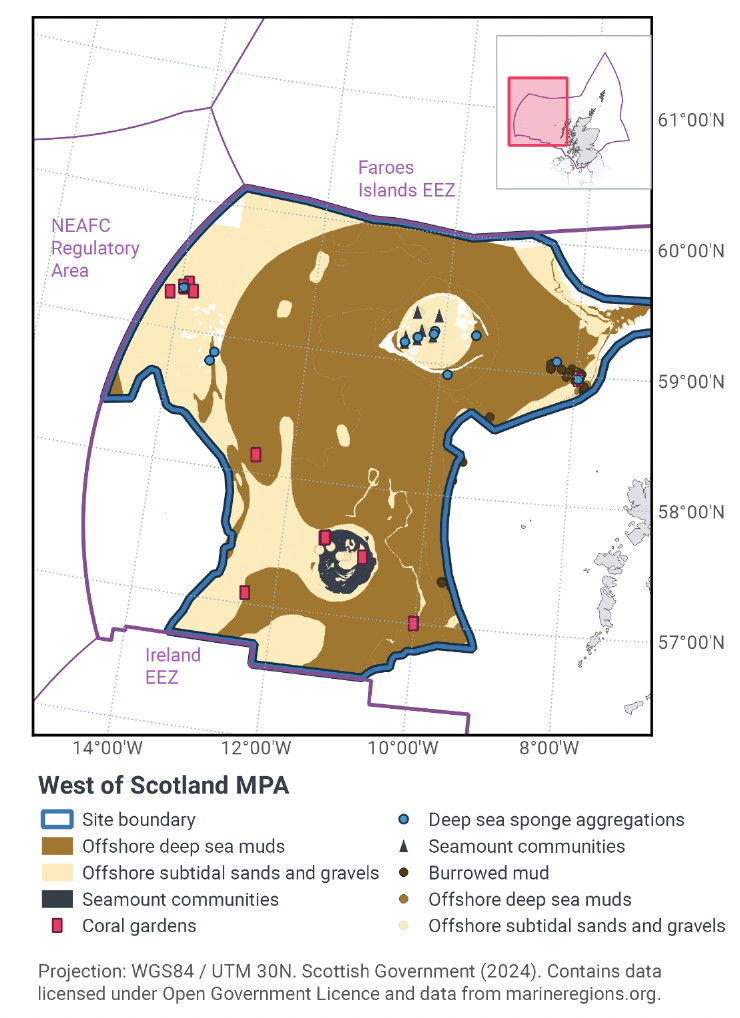
The West of Scotland deep-sea marine reserve (Figure 1 and 2) is 107,718 km2 in size. The shallowest area within the NCMPA is approximately 400 m below sea-level and the deepest section is 2,500 m below sea-level. It covers a diverse marine landscape to the west of Scotland; from the steep gradient of the continental slope across the sediment plains of the Rockall Trough, to the slopes of George Bligh Bank and Rockall Bank, with two isolated seamounts (Anton Dohrn and Rosemary Bank). It is the geological and geomorphological features that define this marine landscape, with volcanic igneous rock protrusions forming the seamounts and the large banks at the western extent of the deep-sea marine reserve. Slide deposits are a characteristic feature along the Scottish continental slope, while other geomorphological and glacial remnant features (such as sediment wave fields, scour moats, turbidite accumulations, and iceberg plough marks) form the landscape of the seabed (Brooks et al. 2011).
The West of Scotland NCMPA has been designated for the following protected features:
- Habitat features:
- Burrowed mud (including sea-pens)
- Coral gardens
- Cold-water coral reefs (including Lophelia pertusa reefs)
- Deep-sea sponge aggregations
- Offshore deep-sea muds
- Offshore sands and gravels
- Seamount communities
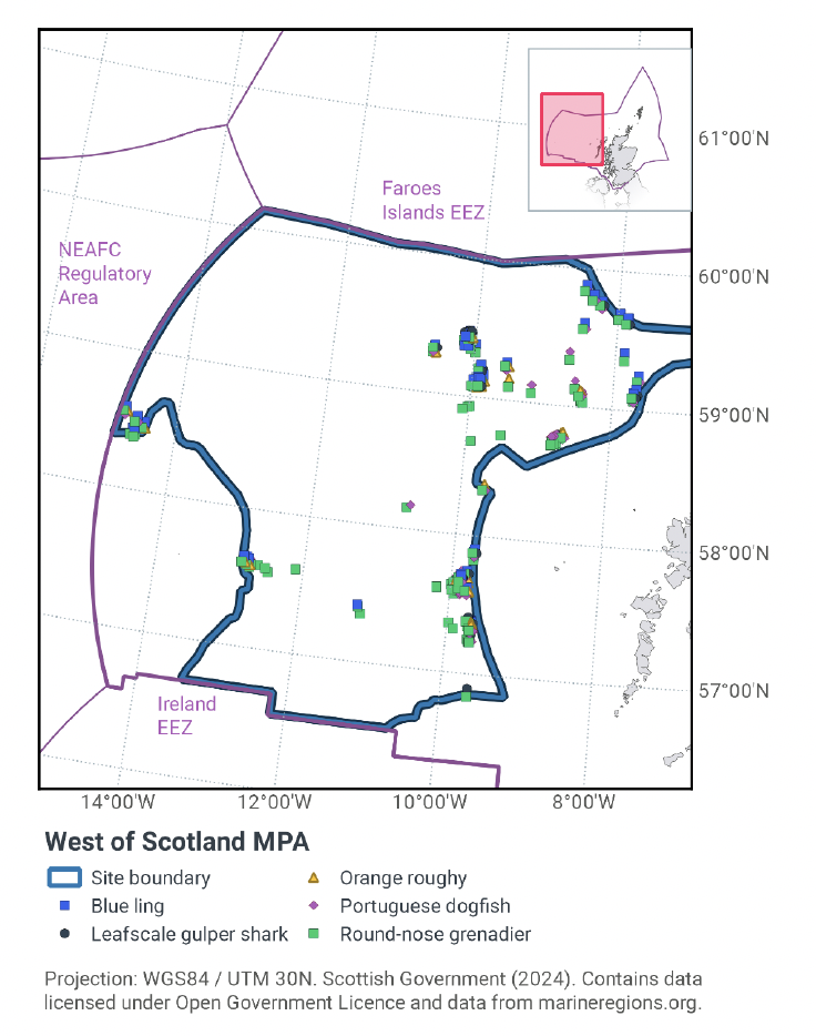
- Species features:
- Blue ling (Molva dypterygia)
- Leafscale gulper shark (Centrophorus squamosus) / gulper shark (Centrophorus granulosus)
- Orange roughy (Hoplostethus atlanticus)
- Portuguese dogfish (Centroscymnus coelolepis)
- Round-nose grenadier (Coryphaenoides rupestris)
- Large scale feature:
- Seamount
- Geological and geomorphological features:
- A range of features representative of the Key Geodiversity Areas
All of the protected biodiversity features of the deep-sea marine reserve are Priority Marine Features (PMFs); these are habitats and species considered to be of conservation priority in Scotland’s seas. Coral gardens, cold-water coral reefs (including Lophelia pertusa reefs), deep-sea sponge aggregations, seamount communities, leafscale gulper shark (Centrophorus squamosus), gulper shark (Centrophorus granulosus), orange roughy (Hoplostethus atlanticus) and Portuguese dogfish (Centroscymnus coelolepis) are also listed as OSPAR Threatened and/or Declining habitats or species in the North-East Atlantic region. Burrowed mud (including sea-pens), coral gardens, cold-water coral reefs (including Lophelia pertusa reefs), deep-sea sponge aggregations and seamount communities are all Vulnerable Marine Ecosystems (VMEs) as identified by the joint International Council for the Exploration of the Sea (ICES) / North-west Atlantic Fisheries Organisation (NAFO) Working Group on Deep-Water Ecology (WGDEC) for the North-east Atlantic. These are habitats/ecosystems that are classified as vulnerable due to the characteristics they possess e.g. they may be fragile and susceptible to damage.
Deep-sea sponge aggregations, cold-water coral reefs and coral gardens are known as ‘habitat formers’. The physical structures they create provide an environment that other species can colonise, and they support a diverse community of associated species (OSPAR 2009, 2010a, 2010b). Sponges may also play a significant role in silicon regulation by providing a long-term sink for silicon (Maldonado et al. 2012, Tréguer and Rocha, 2013), while coral skeletons act as a long-term store of carbon (OSPAR, 2009).
The deep-sea marine reserve protects six deep-sea fish species (blue ling (Molva dypterygia), orange roughy, Leafscale gulper shark / gulper shark, Portuguese dogfish, and round-nose grenadier (Coryphaenoides rupestris). Leafscale gulper shark and gulper shark are presented as a feature complex due to difficulties in their identification. The NCMPA contains characteristic habitat for round-nose grenadier, leafscale gulper shark, gulper shark, and Portuguese dogfish. Round-nose grenadier are resident within the MPA, and this is one of only 17 locations globally where gulper shark has been reported. The NCMPA protects important aspects of these species' life-cycles, such as spawning areas (Large et al. 2010; Moura et al. 2014). There is limited understanding on the majority of these species, however, and further scientific research is required to assess the importance of the site for these species.
The two seamounts (Rosemary Bank and Anton Dohrn) are protected as large-scale features of the deep-sea marine reserve and for the rich Seamount communities they support (Figure 1 and 2). The seamounts create a very different environment to the sedimentary plains of the Rockall Trough. The dynamic hydrographic environment surrounding the seamounts increases food availability to suspension feeders such as sponges and corals that colonise the seamounts. Many fish species such as blue ling, black scabbard (Aphanopus carbo) and mesopelagic lantern fish (Lampanyctus sp.) are attracted to seamounts for feeding or spawning. The concentrations of fish and other prey species around seamounts also attracts larger predators and marine mammals such as Atlantic white-sided dolphin (Lagenorhynchus acutus) and sperm whale (Physeter macrocephalus), which have been observed in high numbers around these features (Clarke 2007, Macleod et al. 2003, Weir et al. 2001). Further details of the NCMPA can be found in the West of Scotland NCMPA Ecological Overview document available on JNCC’s site information centre.
The conservation objectives for the protected features within the West of Scotland NCMPA are: Subject to natural change, recover the burrowed mud, coral gardens, cold-water coral reefs, deep-sea sponge aggregations, offshore deep-sea muds, offshore sands and gravels and seamount communities to favourable condition, such that:
- their extent is stable or increasing;
- their structures and functions, quality, and the composition of their characteristic biological communities are such as to ensure that they are in a condition which is healthy and not deteriorating.
Subject to natural change, conserve the blue ling and recover the leafscale gulper shark, gulper shark, orange roughy, Portuguese dogfish and round-nose grenadier to favourable condition, such that:
- the quality and quantity of its habitat;
- the composition of its population is such to ensure that the population is maintained in numbers which enable it to thrive.
Subject to natural change, conserve the geological and geomorphological features characterising the protected Key Geodiversity Areas within the deep-sea marine reserve; bioherm reefs, continental slope turbidite canyons, erosional scour fields, iceberg ploughmarks, ice-distal and glacimarine facies, ice-proximal and ice-contact facies (e.g. mega-scale glacial lineations), large bank (Palaeogene igneous centre), parasitic cones, prograding wedge, scour moat, seamount, sediment drifts, sediment wave field, slide deposit, slide scars, small scale ridges, sub-glacial tills, turbidite accumulations and the large-scale feature seamounts, such that:
- their extent, component elements and integrity are maintained; Their structure and functioning are unimpaired; and
- their surface remains sufficiently unobscured for the purposes of determining whether the aforementioned points are satisfied.
For burrowed mud, coral gardens, cold-water coral reefs, deep-sea sponge aggregations, offshore deep-sea muds, offshore sands and gravels, seamount communities, leafscale gulper shark, gulper shark, orange roughy, Portuguese dogfish and round-nose grenadier, the feature condition has been assessed by JNCC as being ‘Unfavourable’. For Blue ling, the feature condition has been assessed by JNCC as being ‘Favourable’.
With regards to the scope of this assessment, JNCC considers that the large-scale feature and/or geomorphological features are unlikely to be impacted by fishing activities within the site. As such, these features are not considered further in this assessment. More information regarding the designation of the West of Scotland NCMPA is available in the Designation Order.
More information regarding the conservation objectives and feature condition for the protected features of West of Scotland NCMPA is available within the site’s Conservation Objectives and Management Advice document.
With regards to the scope of this assessment, JNCC considers that the seamount large scale feature is unlikely to be impacted by fishing activities within the site. As such, this feature is not considered further in this assessment. For the geological and geomorphological features, iceberg plough mark fields and bioherm reefs may be sensitive to the pressures associated with fishing activities occurring within the MPA, however these geographically overlap with other features of the NCMPA (i.e. iceberg plough mark fields overlap Offshore sands and gravels, and bioherm reefs overlap Seamount communities, cold-water coral reefs, and coral garden features). Therefore, the assessment for the biodiversity features will also apply to these iceberg plough mark fields and bioherm reefs features, so these geological and geomorphological features have therefore not been considered further in this assessment. JNCC also considered the other geological and geomorphological features to be unlikely to be impacted by fishing activities within the site. As such, these other features are not considered further in this assessment.
1.3 Activities assessed
The assessments consider the impacts of fisheries activities at each NCMPA in terms of the conservation objectives stated for the protected sites. This was deemed appropriate/necessary to do, in order to assist in identifying potential management measures.
In this context, the implications of the fishing activity in view of the conservation objectives for the NCMPA are being assessed through the fisheries screening stage (Part A), the fisheries assessment (Part B), and the in combination (cumulative effect) assessment (Part C).
Fisheries assessments use the best available evidence to fully consider potential impacts of commercial fishing activity, and in-combination (cumulative) effects with other activities, against the conservation objectives for the site. If the assessment concludes that use of certain fishing gear types would or might hinder the achievement of the conservation objectives of the site, management measures will be considered.
Commercial sea fishing activity has the potential to vary in nature and intensity over time. This assessment considers fishing activity based on activity levels and type between 2015-2019. This date range was considered to provide the best available data on current fishing activity levels for the assessment. Using a five year date range provides an average view of fishing activity within the site; latter years (2020 – 2021) were not considered representative of regular fishing activity due to the Covid pandemic. The selected date range (2015 – 2019) was used consistently across all assessments within the consultation package. Changes in fishing activity after this time period may be considered in future reviews of this assessment (see Section 6).
Contact
Email: marine_biodiversity@gov.scot
There is a problem
Thanks for your feedback