Draft Fisheries Assessment – West of Scotland NCMPA: Fisheries management measures within Scottish Offshore Marine Protected Areas (MPAs)
These assessments look at the fishing activity occurring within each offshore MPA and SAC and assess the potential impacts of this activity on the protected features within each site. This assessment is for West of Scotland NCMPA.
4. Part C Assessment- In combination assessment
4.1 In combination assessment overview
Part C of this considers the cumulative impacts, which may occur over space and time, in relation activities occurring within the MPA. Activities assessed in this section include the following:
- Fishing activity/pressure combinations which were excluded in Part A of this assessment as not being capable of impacting the feature;
- Fishing interactions assessed in Part B that would not hinder the conservation objectives for the site; and
- Activities occurring within West of Scotland NCMPA that are not related to fishing.
Fishing activities including demersal trawls, demersal seines and anchored nets/lines have been identified in Part B as requiring management and will therefore not be considered in Part C. Pelagic fishing however was not considered to have a significant effect on their own and is assessed in combination with other activities occurring at the site in Part C.
4.2 Other offshore region activities screening
To determine activities, not related to fishing activities, to be included within this part of the assessment, a distance of 5 km was selected as suitable to capture any potential source receptor pathways that could impact the site in combination with effects of the fishing activities assessed. A 5 km buffer was therefore applied to the site boundary to identify relevant activities.
Activities not related to fishing activities were identified using the Scottish Government’s marine mapping tool. The JNCC Conservation Advice package, and other resources on the JNCC Site Information Centre for West of Scotland MPA, were also screened for activities occurring in the site that should be considered in the in-combination assessment.
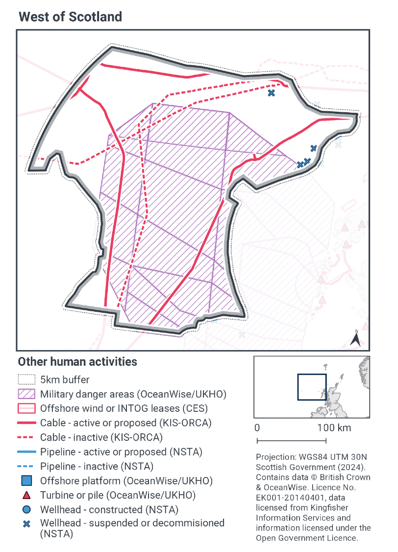
The map to display offshore region activities (see Figure 6) was derived from OceanWise’s Marine Themes Vector data (July 2023 version), Crown Estate Scotland leases (September 2023 version), Kingfisher Information Services Offshore Renewable Cable Awareness (KIS-ORCA, as of December 2023 held under licence) and North Sea Transition Authority (NSTA, as of December 2023, data held under Oil and Gas Authority open licence). The Marine Themes “Industrial” was filtered to show offshore region platforms, wellheads, piles, turbines, cables, and pipelines. Features marked as “not in use”, “not present”, “decommissioned”, or “removed” were excluded. The “Administrative” data were filtered to only show military exercise areas which included danger areas.
4.3 Other offshore region activities occurring within West of Scotland NCMPA
The screening exercise using the Scottish Government’s marine mapping tool identified the presence of cables and wellheads within the site, and a military danger area overlapping a large proportion of the site (see Figure 6). Table 6 provides a list of the relevant activities, including cable, wellheads and military activity which were considered in combination with the fishing activities occurring within West of Scotland NCMPA.
The Activities and Management section of the JNCC Site Information Centre for West of Scotland did not indicate any other activities occurring within the site.
| Relevant activity | Description |
|---|---|
| Oil and gas infrastructure (wellheads) | A number of wellheads are located within the north east corner of the MPA, however these are all suspended or decommissioned. |
| Telecommunication cables | Five telecommunications cables run through the site, and these are a mixture of both active, proposed and inactive cables. |
| Military danger areas | A large proportion of the site overlaps a military danger area, including that associated with Military of Defence practice areas. This is a surface or firing danger area, including for torpedo exercise. |
4.4 Potential pressures exerted by fishing and other activities
To identify the specific pressures that the activities exert on the West of Scotland NCMPA features, the JNCC Marine Pressures-Activities Database (PAD) v1.5 2022 was used (Table 7).
Table 7 shows that there are no pressures caused by pelagic activities or telecommunications cables that have the potential for in-combination effects. Table 7 details the pressures exerted by the telecommunication cables activities (Y- pressure exerted, N- pressure not exerted) and the associated risk profile, as taken from the JNCC Pressures Activities Database (PAD) v1.5.
Neither of the activities undertaken within the military dangers area (surface or firing danger area) and the activities of the suspended or decommissioned oil and gas infrastructure (wellheads) were likely to have pressures of concern that could overlap with those exerted by pelagic fishing and to which the protected features of the site is sensitive.
It is only those pressures that are associated with the fishing activities (not assessed in Part B) and the other relevant activities, that have been discussed below. Any pressures that are only associated with the relevant activities, and not the fishing activities, are not within the scope of this assessment.
| PAD Pressure | Fishing activity | Telecommunications cables | ||
|---|---|---|---|---|
| Pelagic Fishing | Decommissioning | Laying, burial and protection | Operation & maintenance | |
| Above water noise | Y- Low risk | Y- Low risk | Y- Low risk | Y- Low risk |
| Abrasion/disturbance of the substrate on the surface of the seabed | N | Y - Medium-high | Y - Medium-high | Y - Medium-high |
| Barrier to species movement | Y- Low risk | N | N | N |
| Changes in suspended solids (water clarity) | N | Y- Low risk | Y- Low risk | Y- Low risk |
| Collision ABOVE water with static or moving objects not naturally found in the marine environment (e.g., boats, machinery, and structures) | Y- Low risk | Y- Low risk | Y- Low risk | Y- Low risk |
| Collision BELOW water with static or moving objects not naturally found in the marine environment (e.g., boats, machinery, and structures) | Y- Low risk | Y- Low risk | Y- Low risk | Y- Low risk |
| Deoxygenation | Y- Low risk | Y- Low risk | Y- Low risk | N |
| Habitat structure changes - removal of substratum (extraction) | N | Y- Low risk | N | N |
| Hydrocarbon & PAH contamination. Includes those priority substances listed in Annex II of Directive 2008/105/EC. | Y- Low risk | Y- Low risk | Y- Low risk | Y- Low risk |
| Introduction of light | Y- Low risk | Y- Low risk | Y- Low risk | Y- Low risk |
| Introduction or spread of invasive non-indigenous species (INIS) | Y- Low risk | N | Y- Low risk | Y- Low risk |
| Litter | Y- Low risk | Y- Low risk | Y- Low risk | Y- Low risk |
| Nutrient enrichment | N | Y- Low risk | Y- Low risk | N |
| Organic enrichment | Y- Low risk | N | N | N |
| Penetration and/or disturbance of the substrate below the surface of the seabed, including abrasion | N | Y - Medium-high | Y- Low risk | Y - Medium-high |
| Physical change (to another seabed type) | N | Y- Low risk | Y - Medium-high | Y- Low risk |
| Physical change (to another sediment type) | N | Y- Low risk | Y- Low risk | Y- Low risk |
| Removal of non-target species | Y - Medium-high | N | N | N |
| Removal of target species | Y - Medium-high | N | N | N |
| Smothering and siltation rate changes (Light) | N | N | N | Y- Low risk |
| Synthetic compound contamination (incl. pesticides, antifoulants, pharmaceuticals). Includes those priority substances listed in Annex II of Directive 2008/105/EC. | Y- Low risk | Y- Low risk | Y- Low risk | Y- Low risk |
| Transition elements & organo-metal (e.g. TBT) contamination. Includes those priority substances listed in Annex II of Directive 2008/105/EC. | Y- Low risk | Y- Low risk | Y- Low risk | Y- Low risk |
| Underwater noise changes | Y- Low risk | Y- Low risk | Y- Low risk | Y- Low risk |
| Vibration | N | Y- Low risk | Y- Low risk | Y- Low risk |
| Visual disturbance | Y- Low risk | Y- Low risk | Y- Low risk | Y- Low risk |
| Water flow (tidal current) changes, including sediment transport considerations | N | Y- Low risk | Y- Low risk | Y- Low risk |
4.5 Part C Conclusion
Scottish Ministers conclude that the remaining fishing activities (pelagic fishing) in-combination with other relevant activities will not hinder the achievement of the conservation objectives for West of Scotland NCMPA.
Contact
Email: marine_biodiversity@gov.scot
There is a problem
Thanks for your feedback