Draft Fisheries Assessment – Wyville-Thomson Ridge SAC: Fisheries management measures within Scottish Offshore Marine Protected Areas (MPAs)
These assessments look at the fishing activity occurring within each offshore MPA and SAC and assess the potential impacts of this activity on the protected features within each site. This assessment is for Wyville-Thomson Ridge SAC.
1. Introduction
1.1 Scope of the Wyville Thomson Ridge SAC assessment
The geographic scope of this assessment covers the whole of Wyville Thomson Ridge SAC, within the Scottish offshore marine region (12- 200 nautical miles, nm). The purpose of this assessment is to determine whether the current levels of fishing activity occurring within the site are compatible with the conservation objectives of the Wyville Thomson Ridge SAC and to identify options for management measures.
In this assessment, Scottish Ministers uses the best available evidence to review the site characteristics and current fishing activity (Part A), both taken alone and in combination with other relevant activities (Part C), to determine if there is the potential for these activities to have a likely significant effect (LSE) on the protected feature of the site (Annex I Reef). Any fishing activities with the potential for LSE either alone or in combination with other relevant activities are considered further to assess whether they could result in an adverse effect on site integrity (Part B).
Where there is the potential for an adverse effect on site integrity, management measures are identified for the site by Scottish Ministers. These measures are considered in light of the conservation objectives, biological characteristics, current fishing activity and existing fisheries restrictions for Wyville Thomson Ridge SAC. A final decision on which measures, if any, are to be adopted will follow upon a statutory consultation exercise and will take into account all relevant statutory obligations incumbent upon Scottish Ministers.
A methodology document has been prepared to aid understanding of these assessments.
1.2 Site description
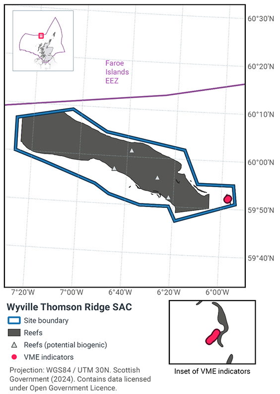
The Wyville Thomson Ridge SAC (Figure 1) is located approximately 150 km north west of Cape Wrath and extends in a north westerly direction towards the Faeroe Bank. Wyville-Thomson Ridge SAC is approximately 20 km wide and 70 km long and rises from over 1000 m depth to less than 400 m at the summit. The Ridge divides the warmer waters of the Rockall Trough from the cooler waters of the Faroe-Shetland Channel, and is a transitional area between the two water masses.
The ridge is composed of extensive areas of stony reef interspersed with gravel areas and bedrock reef along its flanks. The stony reef is thought to have been formed by the ploughing movement of icebergs through the seabed at the end of the last ice age. These iceberg ‘ploughmarks’ consist of ridges of boulders, cobbles and gravel where finer sediments have been winnowed away by high energy currents at the site, interspersed with finer sediment troughs up to 10 m deep (Masson, Bett, & Jacobs, 2000).
The bedrock and stony reef areas in the site support diverse biological communities representative of hard substrate in deep water, including a range of sponges; stylasterid, cup and soft corals; brachiopods; bryozoans; dense beds of feather stars and brittle stars; sea urchins, sea cucumbers and sea spiders (Masson, Bett, & Jacobs, 2000);(Howell, Davies, Hughes, & Narayanaswamy, 2007)(Henry & Roberts, 2014); (Morris, Stamp, & Goudge, 2014). Communities on the bedrock reef vary in species composition between the two sides of the site due to the influences of different water masses on either side of the ridge (Howell, Davies, Hughes, & Narayanaswamy, 2007).
In 2019, ICES received 405 new records of vulnerable marine ecosystems (VME) indicators and/or VME habitats in EU waters, some of which are located in the Wyville Thomson Ridge SAC (ICES, 2019). These records are found in association with the protected feature of the site (Figure 1). VMEs are particularly sensitive to demersal static gears (in addition to demersal mobile gears) and the available records provide evidence of the existence or potential for VME habitats.
JNCC conservation advice statements (2018) state the overall condition of the site’s qualifying feature is in unfavourable condition and therefore needs to be restored to favourable condition.
The conservation objectives for Annex I Reef At Wyville Thomson Ridge SAC are:
subject to natural change, maintain or restore the reef in/to favourable condition, such that:
- The extent and distribution of the qualifying habitat in the site;
- The structure and function of the qualifying habitat in the site; and
- The supporting processes on which the qualifying habitat relies
are maintained or restored, thereby ensuring the integrity of the site and also making an appropriate contribution to conservation status of Annex I habitats (see ‘Conservation objective and Advice on Operations’ 2018) in the Wyville-Thomson Ridge SAC: Relevant Documentation & Conservation Advice 2018.
1.3 Activities assessed
The process followed to conduct this ‘Fisheries Assessment’ is in line with the process for a Habitats Regulation Appraisal, as required under Article 6(3) of Council Directive 92/43/EEC of 21 May 1992 on the conservation of natural habitats and of wild fauna and flora (the Habitats Directive) and for sites within the offshore region under Regulation 28 of the Conservation of Offshore Marine Habitats and Species Regulations 2017.
In this context, fishing activity within the SAC is considered to be the plan or project, and the implications of fishing activity in view of the conservation objectives for the SAC are assessed through the fisheries screening stage (Part A), the fisheries assessment (Part B), and the in combination (cumulative effect) assessment (Part C).
Fisheries assessments use the best available evidence to fully consider potential impacts of commercial fishing activity, and in-combination (cumulative) effects with other plans and projects, against the conservation objectives for the site. If the assessment concludes that use of certain fishing gear types is not compatible with the conservation objectives of the site, management measures will be considered.
Commercial sea fishing activity has the potential to vary in nature and intensity over time. This assessment considers fishing activity based on activity levels and type between 2015-2019. This date range was considered to provide the best available data on current fishing activity levels for the assessment. Using a five year date range provides an average view of fishing activity within the site; latter years (2020 – 2021) were not considered representative of regular fishing activity due to the Covid pandemic. The selected date range (2015 – 2019) was used consistently across all assessments within the consultation package. Changes in fishing activity after this time period may be considered in future reviews of this assessment (see Section 6).
Contact
Email: marine_biodiversity@gov.scot
There is a problem
Thanks for your feedback