Draft Fisheries Assessment – Wyville-Thomson Ridge SAC: Fisheries management measures within Scottish Offshore Marine Protected Areas (MPAs)
These assessments look at the fishing activity occurring within each offshore MPA and SAC and assess the potential impacts of this activity on the protected features within each site. This assessment is for Wyville-Thomson Ridge SAC.
4. Part C Assessment – In combination assessment
4.1 In-combination assessment overview
This section assess the in-combination provision within under Article 6(3) of Council Directive 92/43/EEC of 21 May 1992 on the conservation of natural habitats and of wild fauna and flora (the Habitats Directive) to take account of the cumulative impacts, which may occur over space and time, in relation to plans or projects which are completed, approved but uncompleted, or proposed. In this context of this assessment, activities considered as compatible with the conservation objectives of Wyville Thomson Ridge SAC in combination with other relevant activities taking place which includes the following:
- Fishing activity/pressure combinations which were excluded in Part A of this assessment as having no likely significant impact;
- Fishing interactions assessed in Part B but not resulting in adverse effects; and
- Plans and projects occurring within Wyville Thomson Ridge SAC that are not related to fishing.
Part B of the assessment identified the potential for adverse effects on the protected features from demersal trawl, however this was not found for demersal static gear (line fishing). Accordingly, line fishing will be assessed within Part C of this assessment.
Although pelagic fishing was shown to occur in the site, as in Part A, pelagic mid-water trawl fishing has been classified as not relevant to the protected features within the site as the activity and feature do not interact. Therefore, there is no potential for in-combination effects.
4.2 Other offshore region activities screening
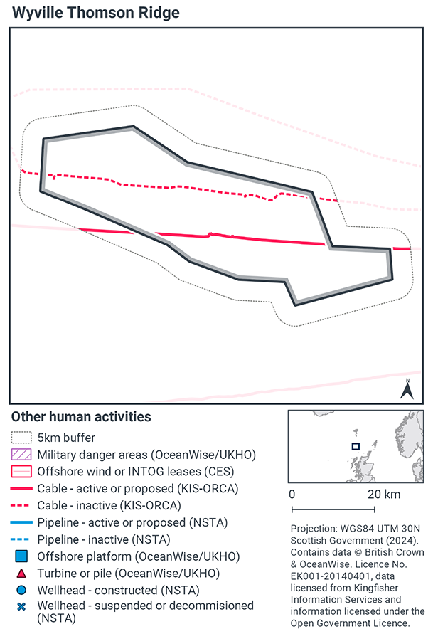
To determine plans and projects not related to fishing activities, a distance of 5 km was selected as suitable to capture any potential source receptor pathways that could impact the site in combination with effects of the fishing activities assessed. A 5 km buffer was therefore applied to the site boundary to identify relevant plans and projects.
Plans and projects not related to fishing activities were identified using the Scottish Government’s marine mapping tool. The NatureScot and JNCC Conservation Objectives and Advice on Operations, and other resources on the JNCC Site Information Centre for Wyville Thomson Ridge SAC, were also screened for activities occurring in the site that should be considered in the in-combination assessment.
The map to display offshore region activities (Figure 4) was derived from OceanWise’s Marine Themes Vector data (July 2023 version), Crown Estate Scotland leases (September 2023 version), Kingfisher Information Services Offshore Renewable Cable Awareness (KIS-ORCA, as of December 2023 held under licence) and North Sea Transition Authority (NSTA, as of December 2023, data held under Oil and Gas Authority open licence). The Marine Themes “Industrial” was filtered to show offshore region platforms, wellheads, piles, turbines, cables, and pipelines. Features marked as “not in use”, “not present”, “decommissioned”, or “removed” were excluded. The “Administrative” data were filtered to only show military exercise areas which included danger areas.
4.3 Other offshore region activities occurring with Wyville Thomson Ridge Reef SAC
The screening exercise using the Scottish Government’s marine mapping tool identified two cables present in the site as subsea telecommunications cables. The exercise did not identify any current pipelines, turbines or piles, wellheads, or offshore region platforms within the site (Figure 4). These findings are supported by the JNCC Site information for Wyville Thomson Ridge SAC which confirms that the area is currently not exploited for oil and gas, so no pipelines or installations occur at the site, and that two telecommunication cables cross the MPA.
Of the two telecommunication cables crossing the site, one was identified as disused/inactive, and the second as active.
4.4 Potential pressures exerted by fishing and other plans or projects
Both telecommunication cables that cross the site are currently in place, removing the risk of any pressures associated with laying, burial and protection, or decommissioning.
Risks associated with operation and maintenance were assessed for the active cable which laterally crosses the southern area of the site. The JNCC Advice on Operations highlighted the Annex I Reef feature to be sensitive to the following pressures associated with operation and maintenance of telecommunication cables:
- Abrasion/disturbance of the substrate on the surface of the seabed;
- Hydrocarbon & PAH contamination;
- Introduction of light;
- Introduction or spread of non-indigenous species;
- Litter;
- Penetration and/or disturbance of the substrate below the surface of the seabed, including abrasion;
- Physical change (to another seabed type);
- Physical loss (to land or freshwater habitat);
- Siltation rate changes (low), including smothering (depth of vertical sediment overburden);
- Synthetic compound contamination (including pesticides, antifoulants, pharmaceuticals);
- Transition elements & organo-metal (e.g. TBT) contamination and
- Vibration
All demersal fishing activity found to take place within the site was assessed within Part B of this assessment and therefore there are no additional fishing activities identified as requiring assessment within Part C.
4.5 Significance of effects/impacts to protect features
Three pressures exerted by the active telecommunication cable located in the site would overlap with the pressures associated with demersal trawl and/or line fishing that have been identified in Part B of this assessment.
These pressures are:
- Abrasion/disturbance of the substrate on the surface of the seabed
- Penetration and/or disturbance of the substrate below the surface of the seabed, including abrasion and
- Siltation rate changes (low), including smothering (depth of vertical sediment overburden).
Due to the sensitivity of the protected feature to the three pressures identified, management would be required to mitigate the in-combination effects of operation and maintenance of the active telecommunications cable, with demersal trawl, and line fishing. As Part B has identified the requirement of management measures for demersal fishing trawl activity which exerts these pressures, this would remove the in-combination effect of pressures on the protected feature.
Of the three identified pressures, abrasion/disturbance of the substrate on the surface of the seabed was the only pressure exerted at a medium-high level by line fishing. If the cable needs to be reburied or uncovered for repair, abrasion and physical disturbance will occur. Usually, free-swimming burial machines are deployed for repair and maintenance to shallow bury exposed sections of cable into the seabed. The Advice on Operations for the site shows that the frequency of the activity will be very low.
There is a spatial overlap between the telecommunication cables and line fishing within the site, however as the frequency of activity related to the operation and maintenance of the in-situ cables is considered to be very low, no further management is considered.
Subsequently, the assessment did not identify any in-combination activities that could adversely affect the site integrity of Wyville Thomson Ridge SAC.
4.6 Part C Conclusion
Scottish Ministers conclude that remaining fishing activities in-combination with other relevant activities are compatible with the conservation objectives of the site and will not adversely affect the site integrity of Wyville Thomson Ridge SAC.
Contact
Email: marine_biodiversity@gov.scot
There is a problem
Thanks for your feedback