Extending marine planning zones: consultation
Consultation paper on proposals to extend marine planning zones out to 12 nautical miles
Proposal to extend marine planning zones
There is now growing interest within the fish and shellfish farming sector to develop farms beyond 3 nautical miles from the coast, with developments in technology making farms in this region feasible. This type of innovative development has the potential to reduce environmental interactions and to support fish health and welfare in line with the aims of our Vision for Sustainable Aquaculture. There is also increasing interest in the potential for shellfish farms located beyond 3 nautical miles, including through co-location opportunities with other structures.
It is therefore proposed that the marine planning zones should be extended to 12 nautical miles as originally intended (excluding those marine planning zones that are enclosed by other marine planning zones), to enable businesses to explore opportunities to develop fish and shellfish farms in this zone.
It is considered that the proposed approach to extend all zones out to 12 nautical miles will mean there would be consistency in planning requirements for fish farm developments within the 0-12 nautical mile zone across Scotland. The existing planning process is already well understood by businesses, regulators and other stakeholders.
Extension of the marine planning zones would be carried out by the means of an affirmative Scottish Statutory Instrument (SSI) to amend The Town and Country Planning (Marine Fish Farming) (Scotland) Order 2007
Question 1(a):
Do you agree with the proposal to extend marine planning zones out to 12 nautical miles?
☐ Agree ☐ Disagree
Question 1(b)
Where applicable, please give reasons for your answer.
Mapping work has been undertaken to extend the existing marine planning zones out to 12 nautical miles. The methodology used to define the boundaries of the current marine planning zones can be viewed in the Consultation Paper on Defining Marine Boundaries for Fish Farming, published on 31 October 2005.
In respect of the proposed extensions to the marine planning zones, the original delineations between each coastal local authority remain the same, with those lines extended out to 12 nautical miles by aligning with Scottish Marine Region boundaries where adjacent, and by using a method involving Thiessen polygons elsewhere.
The Thiessen polygon method involves using a computer program that converts the existing polygon boundaries into points, then partitions the 12 nautical mile area into regions closest to those points. Thiessen polygons are also known as Voronoi cells.
The coordinates of these maps will be used to define each marine planning zone in the SSI.
An illustrative map of the proposed marine planning zones, extended out to 12 nautical miles, is provided below
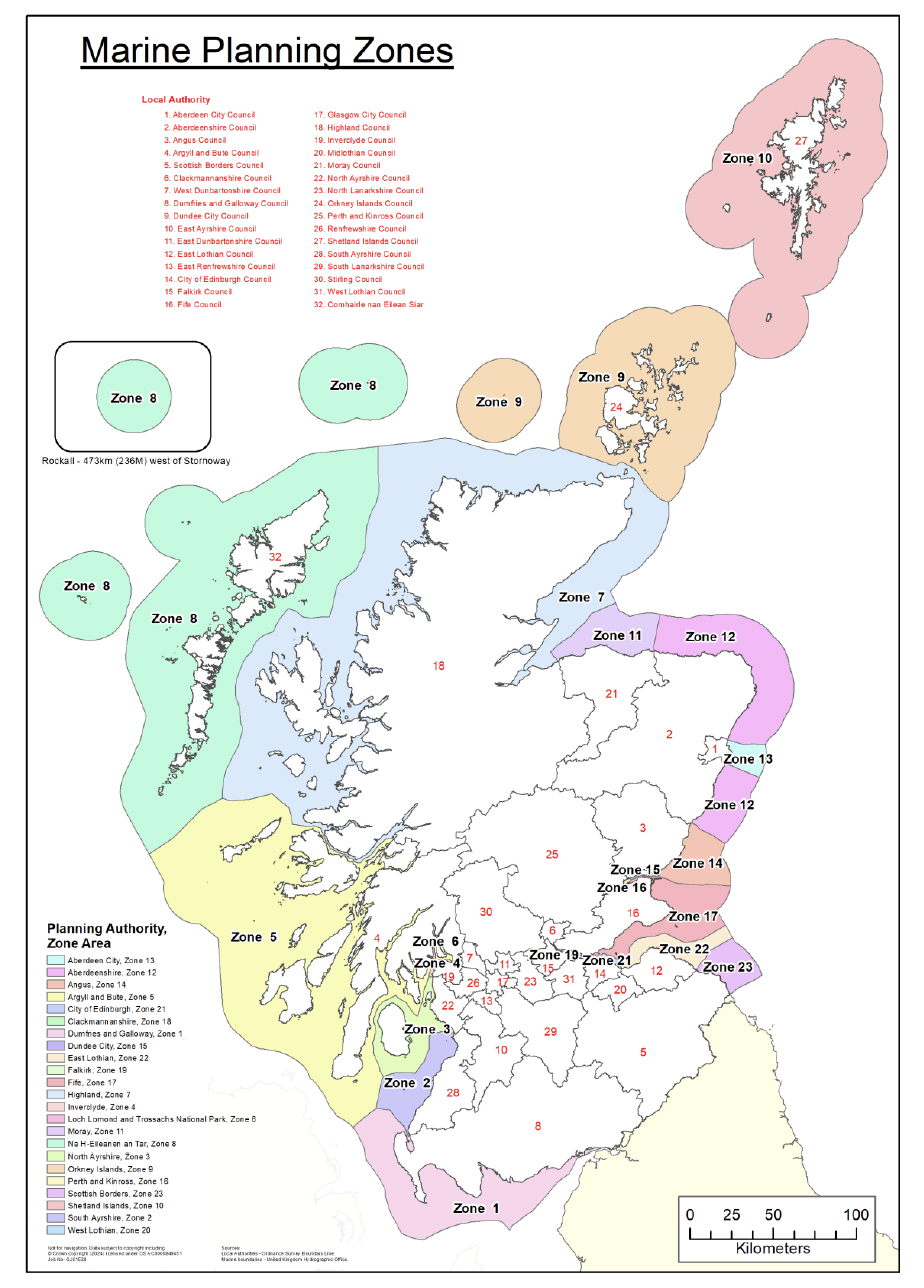
(0-12 nautical miles)
Not for navigation. Data subject to copyright including © Crown copyright (2024) licensed under OS AC0000849451. Job No. GJ01538
Sources:
Local Authorities – Ordnance Survey Boundary Line
Marine Boundaries – United Kingdom Hydrographic Office
An interactive map of the proposed marine planning zones, extended out to 12 nautical miles, can be viewed on marine.gov.scot NMPi. Additional information about the map layer can be viewed at Proposed Marine Planning Zones Extension (0-12 nautical miles) | marine.gov.scot
The finalised interactive map will be available to access on NMPi once the SSI is in force.
Question 2(a):
Do you agree with the proposed marine planning zones, extended out to 12 nautical miles, as presented in the illustrative and interactive maps?
☐ Agree ☐ Disagree
Question 2(b)
Where applicable, please give reasons for your answer.
Contact
Email: AquacultureReview@gov.scot
There is a problem
Thanks for your feedback