Fisheries Management Measures within Scottish Offshore Marine Protected Areas (MPAs) - Site Proposal Document
This document describes the process, justification and evidence used to develop site specific management measures. It outlines key information for each site including their features, and risks of potential pressures.
10. Firth of Forth Banks Complex MPA
10.1 Description and background
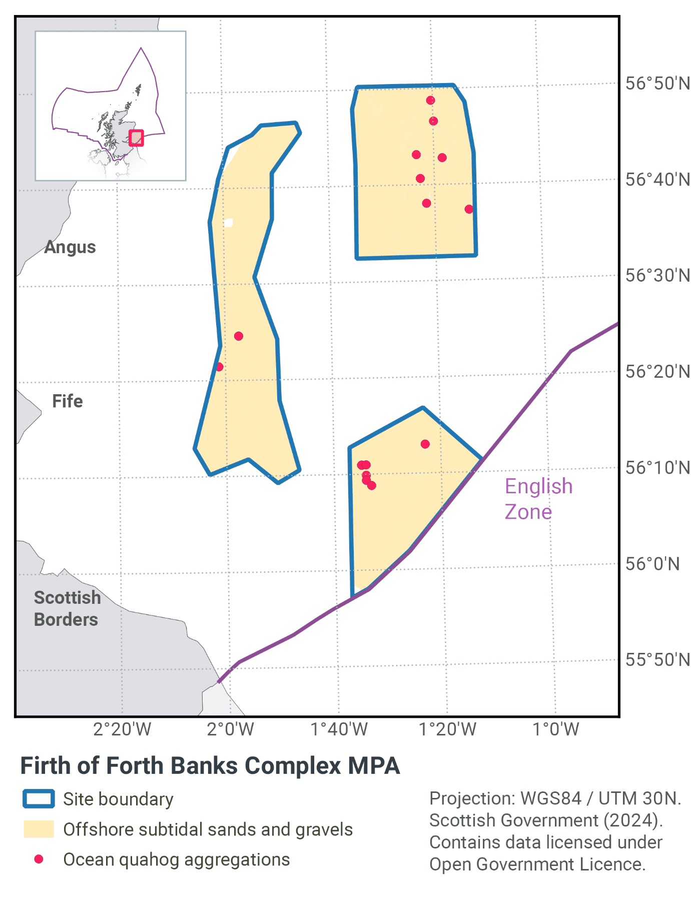
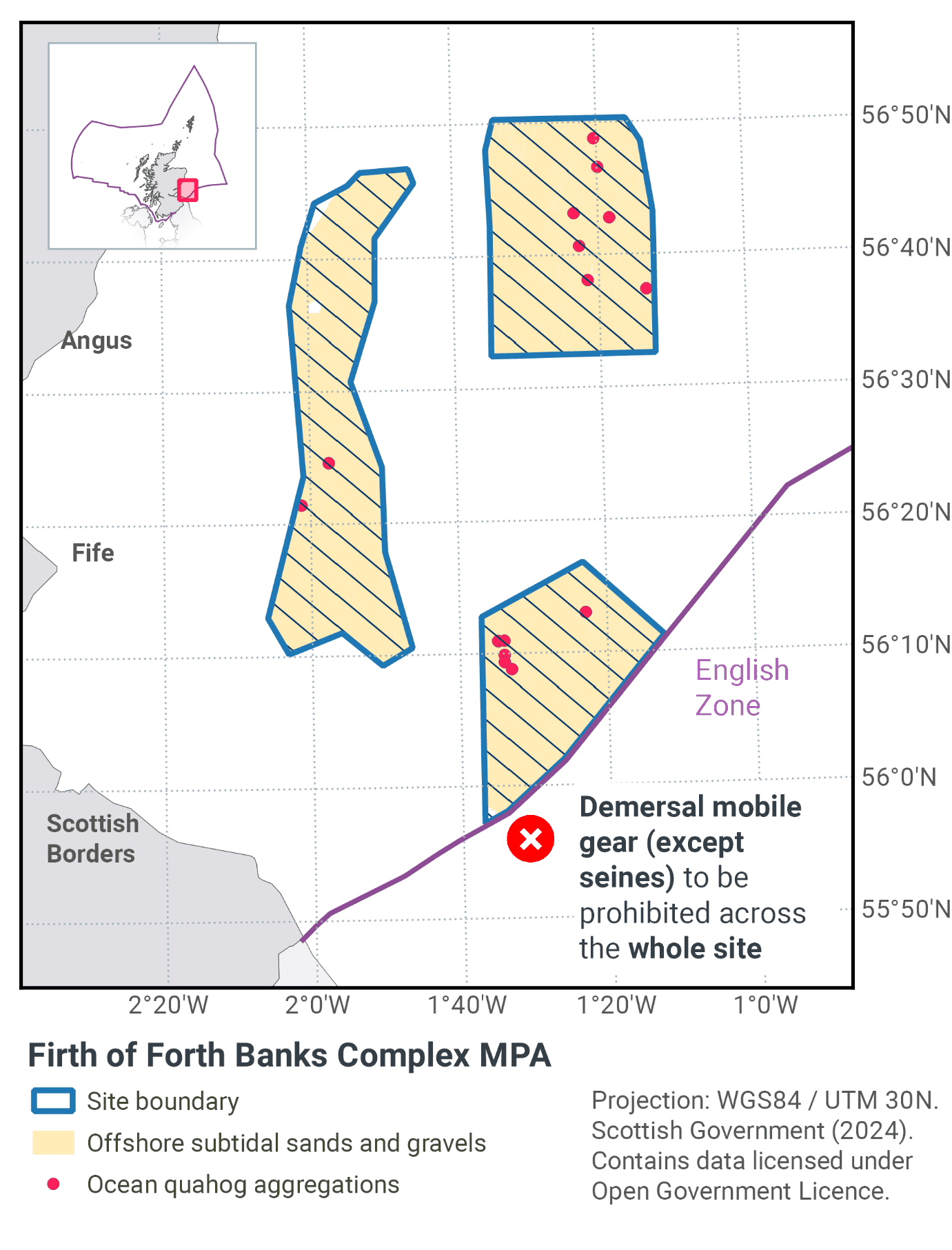
The Firth of Forth Banks Complex MPA is located to the east of Scotland in the outer Firth of Forth, as shown in Figure 18 and Figure 20. The MPA is a composite site made up of three components; Berwick Bank, Montrose Bank and the Wee Bankie (including Scalp Bank). The MPA covers an area of 2,130 km2 and is composed of a series of underwater banks and mounds which are overlaid with a mix of sands and gravels (Figure 19).
Strongly influenced by water currents, the conditions create a mosaic of different habitat types. This mosaic is driven by the interaction between the bank features and oceanic currents, resulting in varying sedimentary deposition rates and a patchwork of different sediment types. The predominant seabed habitats are sands and coarse sediments within the circalittoral and deep circalittoral biological zones across the MPA.
The eastern area has seabed habitats comprising of offshore deep circalittoral sands with small banks of offshore deep circalittoral coarse sediment. As the seabed shallows toward the Wee Bankie area, the raised banks are coarse sedimentary becoming more reflective of shallower inshore sedimentary habitats. This pattern remains the case over the raised areas of this region, with the troughs and deeper channels holding circalittoral muddy sands and deep circalittoral sands (Sotheran & Crawford-Avis, 2014a & b).
The mosaic of sands and gravels support a variety of species, including the ocean quahog (Arctica islandica) which can be found living buried in the sandier sediments. Ocean quahogs are typically found below the surface of medium-to fine-grained sand, sandy mud and silty-sand (Sabatini & Pizzolla, 2008) and in water depths of 4 to over 400 m (Witbaard & Bergman, 2003). Survey data from the MPA confirm that ocean quahog is present within the depth range and sediment types in which they are expected to occur.
Further information can be found in the Site Information Centre.
10.2 Site Features
The Firth of Forth Banks Complex MPA is designated for the following protected features:
- Ocean Quahog aggregations
- Offshore subtidal sands and gravels
- Shelf banks and mounds
- Wee Bankie Key Geodiversity Area.
Ocean quahog aggregations are considered to be Threatened and/or Declining in OSPAR region II (Greater North Sea). The Wee Bankie and Berwick Bank are also considered to have wider functional significance to the overall health and biodiversity of Scotland’s seas; Wee Bankie for foraging seabirds (Daunt et al., 2008; Camphuysen et al., 2011) and grey seals (McConnell et al., 1999, Jones et al., 2013), and Berwick Bank for foraging grey seals (Prime and Hammond, 1990; McConnell et al., 1999; Jones et al., 2013) and as a spawning ground for plaice, the larvae of which may be important source of recruits for the wider region (Lockwood & Lucassen, 1984).
The MPA also represents a wide range of different types of offshore subtidal sand and gravel habitats on the continental shelf. It is considered to be a relatively isolated system and localised hydrodynamics have a positive effect on productivity in the area (Scott et al., 2010).
More information regarding the site selection process for the Firth of Forth Banks Complex MPA is available in the detailed assessment against the Scottish MPA Selection Guidelines.
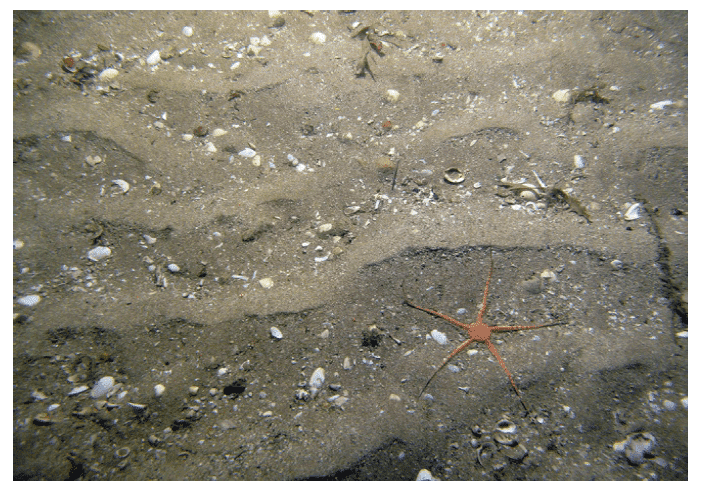
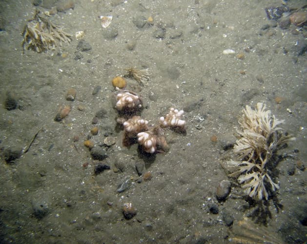
Figure 19. Example images of offshore subtidal sands and gravels feature from Firth of Forth Banks Complex MPA (© JNCC/Marine Scotland Science/Cefas/NLB). a) Brittle star (Ophiuroidea) on rippled sand; b) Dead man's fingers (Alcyonium digitatum), brittle stars (Ophiophrix fragilis) and horn wrack (Flustra foliacea) on gravel and pebbles.
10.3 Site Boundary
The boundary has been set in accordance with the boundary setting principles outlined in the MPA Selection Guidelines.
The MPA is a composite site composed of three components that have been drawn to reflect the distribution and extent of the features for which the MPA was designated. This has included survey records of ocean quahog and areas of sediments considered suitable for ocean quahog colonisation (Sabatini & Pizzolla, 2008). The boundary also encompasses examples of as many different types of offshore sand and gravel habitats as possible that are considered representative of the wider Firth of Forth Banks area. This decision is supported by full coverage seabed habitat mapping (Sotheran & Crawford-Avis, 2014a & b); EUSeaMap and biotope assignment from photographic image and grab samples (Axelsson et al., 2014; Goudge & Morris, 2014; Pearce et al., 2014).
Confidence in the presence and extent of the protected features has been set out in the Data Confidence Assessment.
10.4 Conservation objectives
JNCC’s view on the overall condition of the site’s qualifying features is that Offshore subtidal sands and gravels, and Ocean quahog aggregations are in in unfavourable condition and therefore needs to be restored to favourable condition.
Shelf banks and mounds, and Wee Bankie Key Geodiversity Area are considered to be in favourable condition and therefore need to be maintained in favourable condition.
The conservation objectives for the Firth of Forth Banks Complex MPA are that the protected features:
- so far as already in favourable condition, remain in such condition; and
- so far as not already in favourable condition, be brought into such condition, and remain in such condition
The full conservation advice documents can be found on the JNCC website. This includes the formal conservation advice for the site, background information and the full conservation objectives.
10.5 Pressure from demersal mobile fishing gear
In general, the impact of mobile gear on sand and gravel sediments is relatively well understood. Trawling and dredging tends to cause increased mortality of fragile and long-lived species and favour opportunistic, disturbance-tolerant species, however, the tolerance to disturbance is linked to the energy levels of the area. In higher energy locations, fauna tend to be more adapted to disturbance and as a result tend to be more tolerant of fisheries related disturbance than lower energy locations (Dernie et al., 2003; Hiddink et al., 2006; Kaiser et al., 2006). Stable gravels often support a ‘turf’ of fragile species which are easily damaged by trawling and recover slowly (Collie et al., 2005; Foden et al., 2010).
Evidence suggests that ocean quahog can be caught or damaged by beam trawls (Klein & Witbaard 1993; Witbaard & Klein 1994), and population density has been found to be inversely related to beam trawling effort (Craymeersch et al., 2000). There is insufficient evidence to assess the mortality at a population level caused by otter trawling on ocean quahog. No evidence was found on the effects of shellfish dredging. However, the physical effects of scallop dredging on seabed sediments are similar to those of beam trawls (penetration to depths >5 cm) and so the effects on ocean quahog are likely to be similar. Hydraulic gears penetrate sediments more deeply than other gears and so could be expected to cause a greater mortality, particularly where ocean quahog is the target species (although there is no known direct exploitation of the species in this country).
As with demersal trawls and dredges, demersal seines may impact the structure and function of sedimentary habitats and the long-term survival of their associated species. There are currently no direct studies on the physical impacts of demersal seines. Modelling studies suggest that demersal seines have a large overall footprint (i.e. the surface area covered during one hour fishing) (Eigaard et al. 2016). Hiddink et al. (2017) suggest that depletion of biota is highly correlated with seabed penetration depth by trawls. Seines lack the heavy gear components (e.g. otter doors, trawl shoes) of other mobile demersal gears (Suuronen et al. 2012; Donaldson et al. 2010) and therefore, despite the relatively large footprint, impacts associated with penetration into the sediment are likely to be lower. Eigaard et al. (2016) modelled surface (<2cm) and subsurface (>2cm) impacts and found that demersal seines have some of the smallest proportions of subsurface impact.
10.6 Pressure from demersal static fishing gear
Although the individual impact of a single static fishing operation may be slight, cumulative damage may be significant (Eno et al., 2001; Foden et al., 2010), however sensitivity to low intensity potting is considered low (Hall et al., 2008). Overall, the protected features within the site are not considered to be sensitive to static gear activity.
10.7 Levels of fisheries management considered
Table 14 provides a summary of the fisheries management advice set out against the various options that have been considered.
(Table 14) Summary of fisheries management advice for Firth of Forth Banks Complex MPA
Fisheries management options considered for demersal mobile gears
No additional management: There is a risk of not achieving the conservation objectives for ocean quahog aggregations and offshore subtidal sands and gravels.
Reduce / limit pressures: This level of management would reduce, but not entirely eliminate, the risk of not achieving the conservation objectives for ocean quahog aggregations and offshore subtidal sands and gravels. Appropriate management for ocean quahog could include restrictions on gears known to impact the species, such as scallop and hydraulic dredging. Appropriate management for offshore subtidal sands and gravels could include a zoned approach, where management measures that apply to damaging gears are introduced to protect a proportion of the feature representing the full diversity of sand and gravel habitats across the complex. There may be a greater requirement for restrictions on gears that penetrate deeply into the sediment. Restrictions could be permanent in some cases or temporary/adaptive in others.
Remove / avoid pressures: This level of management would minimise the risk of not achieving the conservation objectives for ocean quahog aggregations and offshore subtidal sands and gravels to the lowest possible levels. This is likely to include restrictions on gears that could impact the features, such as otter trawling, scallop and hydraulic dredging.
Fisheries management options considered for demersal static gears
No additional management: It is unlikely that any additional management of creeling and potting activities will be required, as the risk of not achieving the conservation objectives for ocean quahog aggregations and offshore subtidal sands and gravels associated with these activities is likely to be minimal. However, if static gear fishing intensity increased or monitoring showed evidence of detrimental effects, it may be necessary to apply limits in the future.
10.8 Other fisheries measures which apply to the MPA
Commercial sandeel fishing has been prohibited since 2000 (Regulation (EU) 2019/1241). If this restriction was not in place, and sandeel stocks were healthy, then there would probably be considerably more demersal mobile fishing pressure within the MPA. Therefore, this existing measure is furthering the conservation objectives.
10.9 Proposed fisheries management and rationale
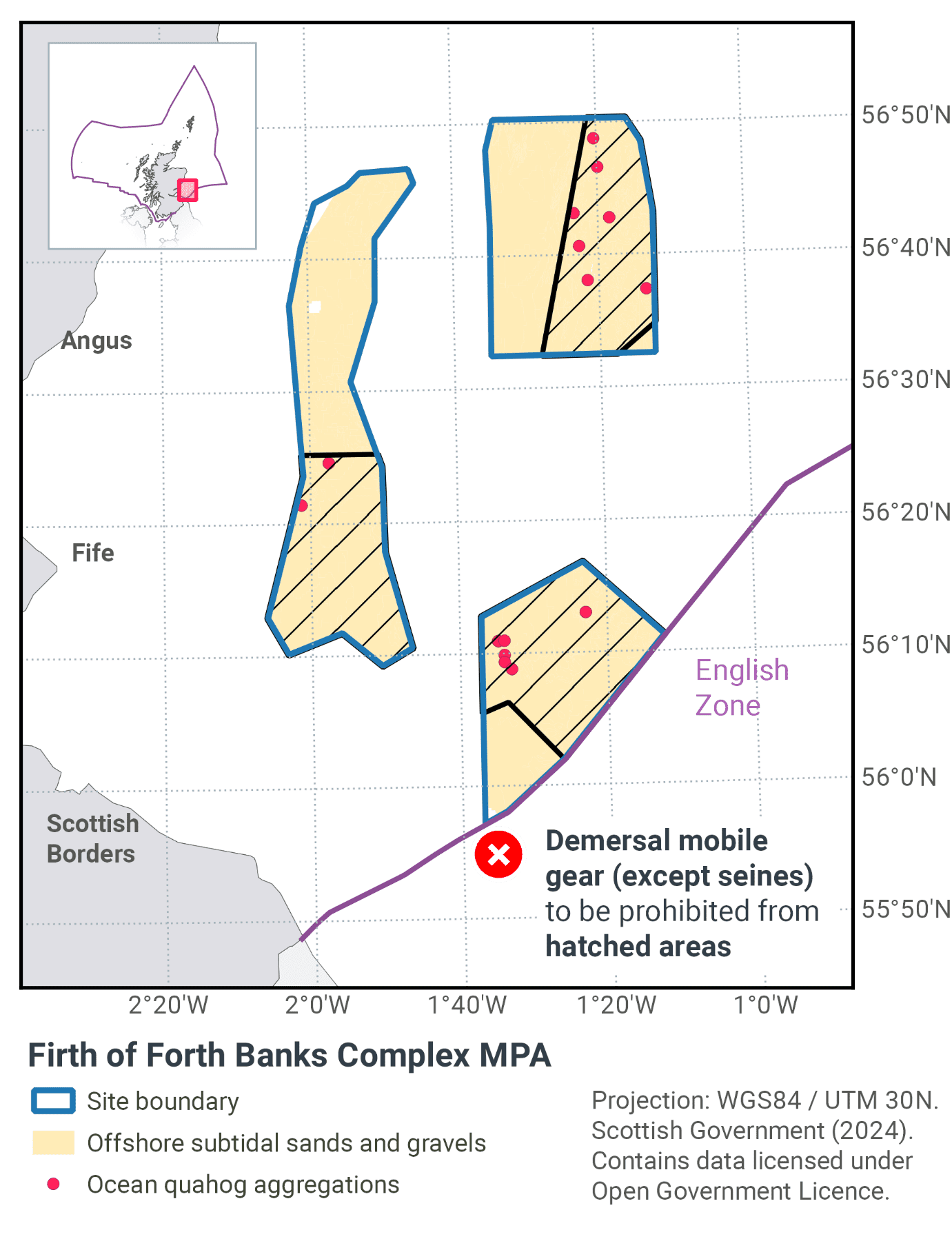
Table 15 and Figure 20 provides details of the proposed fisheries management approach and further explanation is provided. Figure 21 shows the proposed fisheries management for full site prohibitions.
(Table 15) Proposed fisheries management approach for Firth of Forth Banks Complex MPA
Protected feature: Ocean quahog aggregations
Gear type: Demersal mobile (excluding seines)
Proposed management: Remove / avoid pressures
Measures: Management of demersal mobile gear (excluding seines) to protect the entirety of the area in which the feature has been identified.
Protected feature: Offshore subtidal sands and gravels
Gear type: Demersal mobile (excluding seines)
Proposed management: Reduce/ limit pressure
Measures: Zonal management to ensure a proportion of each component biotope is protected from demersal mobile gear (excluding seines)
Protected feature: Ocean quahog aggregations, offshore sands and gravels
Gear type: Demersal static
Proposed management: No additional management
Measures: No demersal static gear measures applied
The management zones have been focused around the distribution of ocean quahog aggregations. In doing so, a proportion of each offshore subtidal sand and gravel biotope is included in these zones. It was very clear from the stakeholder workshop that seine net operations would have little or no effect on the habitats and therefore no management is proposed for that gear type. The same is true for static gears.
By managing a proportion of each biotope of the sands and gravels habitat, then condition is likely to improve upon removal of fishing pressure. Therefore, the site will be moving towards achieving its conservation objectives.
Ocean quahog is listed as an OSPAR threatened and/or declining species in OSPAR region II. These measures would make a significant contribution towards recovery of the species. They should also further progress towards Good Environmental Status in the Greater North Sea, particularly in relation to Descriptors 1 (biological diversity) and 6 (sea-floor integrity).
Contact
Email: marine_biodiversity@gov.scot
There is a problem
Thanks for your feedback