Fisheries Management Measures within Scottish Offshore Marine Protected Areas (MPAs) - Site Proposal Document
This document describes the process, justification and evidence used to develop site specific management measures. It outlines key information for each site including their features, and risks of potential pressures.
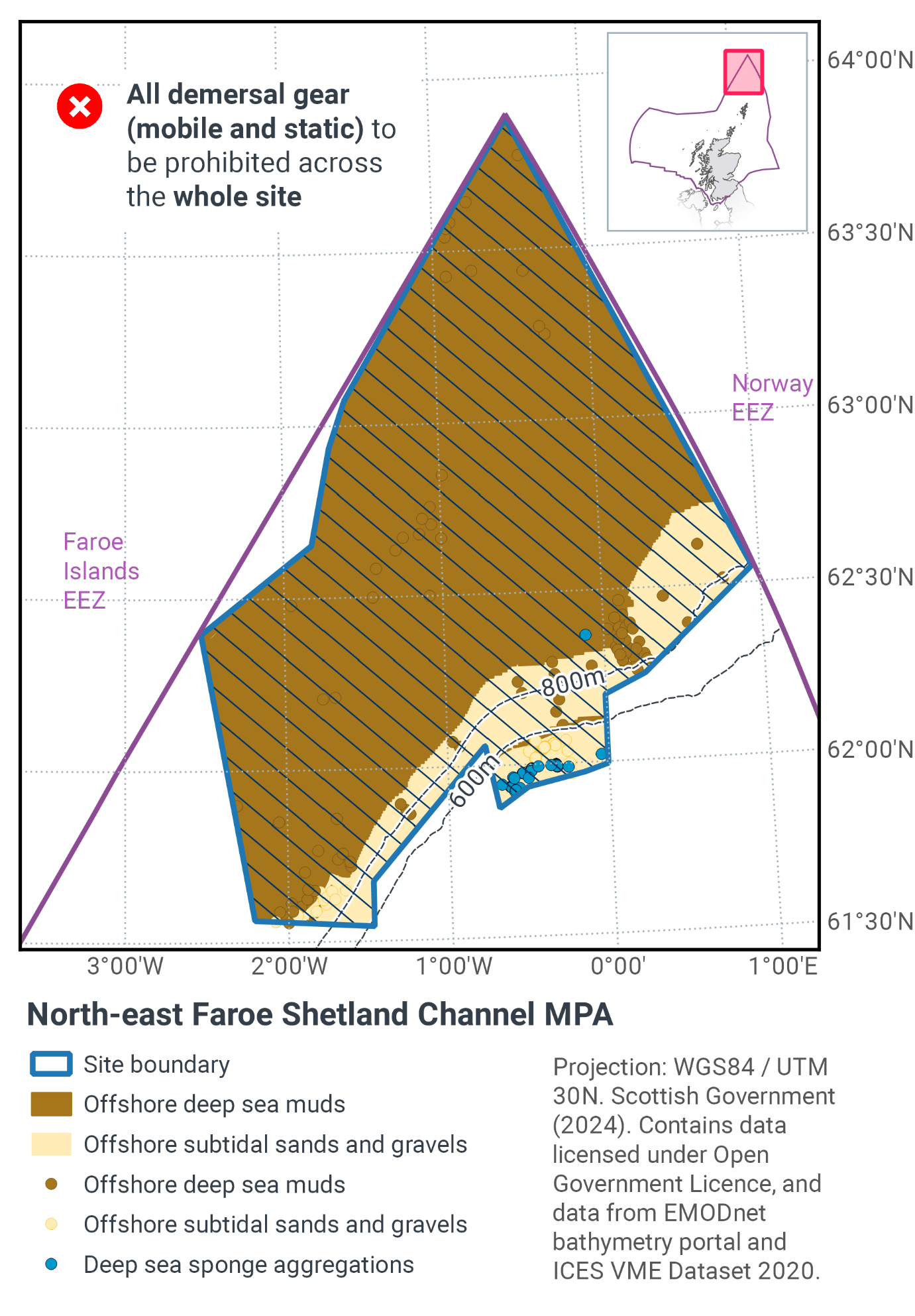
11. North-East Faroe-Shetland Channel MPA
11.1 Description and background
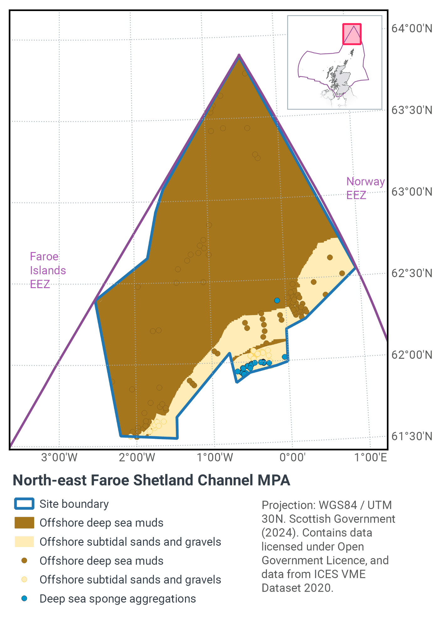
Located to the far north-east of Scottish waters this MPA covers over 23,000 km2 of the north-eastern reaches of the Faroe-Shetland Channel, as shown in Figure 22 and Figure 24. Example images of protected features are shown in Figure 23.
The MPA has a depth range of 330 m – 2420 m extending from the edge of the continental slope down into cooler Arctic influenced waters. The habitats present are strongly influenced by the environmental conditions in the region, which includes a dynamic mixing zone where warmer Atlantic waters flow over cooler Arctic waters.
At depths of 400-600 m, the combination of seabed type and plentiful supply of nutrients are ideal for the establishment of deep-sea sponges. Up to 50 sponge species can be found within the sponge fields, many of which are different to those found in the surrounding areas.
The type of deep-sea sponge aggregation which occurs within the North-East Faroe-Shetland Channel MPA is boreal ‘ostur’ (Howell et al., 2007; Henry & Roberts, 2014). Boreal ‘ostur’ sponge aggregations typically have a high abundance of species of giant sponge (Demospongia). Deeper than 800m, the muddy seabed is home to species tolerant of the cold Arctic-influenced waters.
Sedimentary features within the site are representative of offshore subtidal sands and gravels with sediment type and associated biological communities typically varying with depth. These habitats range from cobbles and boulders in shallower areas of the slope, to finer-grained sands and muds in deeper areas down the slope and in the channel itself (Bett, 2000).
Further information can be found in the Site Information Centre.
11.2 Site Features
The North-East Faroe-Shetland Channel MPA is designated for the following protected features:
- Deep sea sponge aggregations
- Offshore subtidal sands and gravels
- Offshore deep sea muds
- Continental slope
- A wide range of geological and geomorphological features representative of the West Shetland Margin Palaeo-depositional, Miller Slide and Pilot Whale Diapirs Key Geodiversity Areas.
The boreal ostur variant of deep-sea sponge aggregations has only been recorded in the North Sea in Scottish waters. The deep-sea sponge aggregations conform to the OSPAR definition of this Threatened and / or Declining habitat (OSPAR, 2010b). They are also classed as a Vulnerable Marine Ecosystem (VME) according to FAO international guidelines (FAO, 2009). Therefore, this MPA makes a contribution to global commitments to protect VMEs.
More information regarding the site selection process for the North-East Faroe-Shetland Channel MPA is available in the detailed assessment against the Scottish MPA selection guidelines.
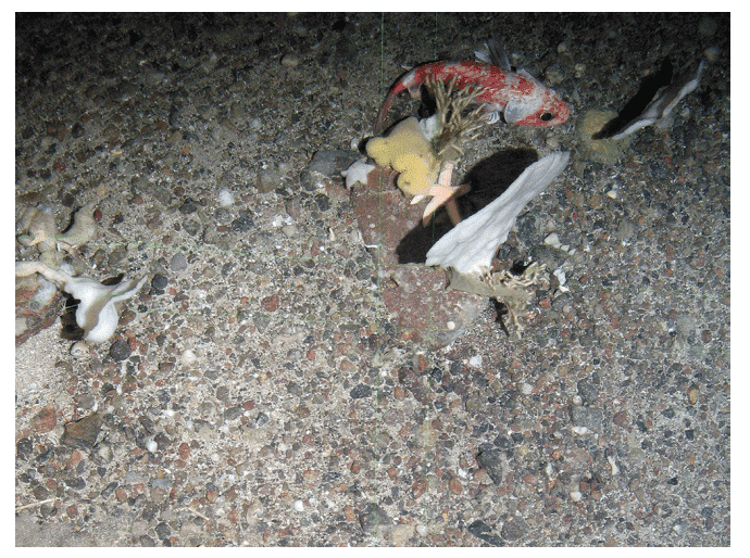
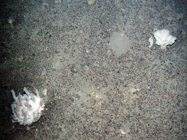
Figure 23. Examples images representative of some of the features within the North-East Faroe-Shetland Channel MPA (© JNCC): a) Rockfish and sponges on offshore subtidal sands and gravels and b) Cathedral sponge with pencil urchins on offshore subtidal sands and gravels.
11.3 Site Boundary
The boundary has been set in accordance with the boundary setting principles outlined in the MPA Selection Guidelines.
It has been drawn to encompass all ground-truthed records of deep-sea sponge aggregations in this part of the Faroe-Shetland Channel that have been verified with high or medium confidence (Henry & Roberts, 2014). The isobaths used to draw the MPA boundary encompass the 400-600 m depth band where deep-sea sponge aggregations are recorded in the Faroe-Shetland Channel (Axelsson, 2003; Howell et al., 2007).
The boundary also captures the range of as many different types of Arctic influenced sediments as possible, and captures variation in benthic biological diversity with depth as highlighted by Bett (2012). The 400-1500 m depth band was used to help define the boundary. This aims to include the full range of environmental conditions within the Faroe-Shetland Channel, from the highly dynamic and varied water masses at 300-600 m, to the Arctic waters where temperatures can be sub-zero at >600 m (Bett, 2012). The MPA also includes the benthic diversity and abundance maxima present in the intermediate water masses between 400 and 700 m (Bett, 2000; Bett, 2001; Narayanaswamy et al., 2005; Narayanaswamy et al., 2010).
Confidence in the presence and extent of the protected features has been set out in the Data Confidence Assessment.
11.4 Conservation objectives
JNCC’s view on the overall condition of the site’s qualifying features is that, other than Deep-sea sponge aggregations, the features are in favourable condition and therefore need to be maintained to favourable condition, and for Deep-sea sponge aggregations to be recovered from unfavourable, to favourable condition.
The conservation objectives for the North-East Faroe-Shetland Channel Nature MPA are that the protected features:
- so far as already in favourable condition, remain in such condition; and
- so far as not already in favourable condition, be brought into such condition, and remain in such condition.
The full conservation advice documents can be found on the JNCC website. This includes the formal conservation advice for the site, background information and the full conservation objectives.
11.5 Pressure from demersal mobile fishing gear
Studies on deep-sea sponge aggregations have found that trawling damages, displaces and removes sponges through direct physical impact as well as from disturbed sediment resettling and causing smothering beyond the path of the trawl itself (OSPAR, 2010b; ICES, 2007; ICES, 2010). Deep-sea sponges have some capacity for recovery from mild damage, but significant disturbance, damage or smothering may result in sponges being unlikely to survive (ICES, 2007; ICES, 2010).
In general, the impact of demersal mobile gear on offshore subtidal sands and gravels is relatively well understood. In high energy locations (i.e. of wave and/or tide exposed) the associated fauna tend to be well adapted to disturbance and as a result are more tolerant of fishing-related disturbance (Dernie et al., 2003; Hiddink et al., 2006). In lower energy locations, such as muddy sands and sand in deep water, sediments tend to be more stable and their associated fauna less tolerant of disturbance (Hiddink et al., 2006; Kaiser et al., 2006).
Stable gravels often support a ‘turf’ of fragile species which are easily damaged by trawling and recover slowly (Collie et al., 2005; Foden et al., 2010). Trawling and dredging tends to cause increased mortality of fragile and long-lived species and favour opportunistic, disturbance-tolerant species (Eleftheriou & Robertson, 1992; Bergman & van Santbrink, 2000). Some particularly sensitive species may disappear entirely (Bergman & van Santbrink, 2000). There is a possibility that exposure to demersal mobile gears may result in some degree of modification relative to the un-impacted state (Bergman & van Santbrink, 2000; Kaiser et al., 2006).
Studies have shown that areas of offshore deep-sea mud habitats subject to mobile fishing activity support a modified biological community with lower diversity, reduction or loss of long-lived filter-feeding species and increased abundance of opportunistic scavengers (Tuck et al., 1998; Ball et al., 2000). This effect was greatest in the more heavily fished offshore areas suggesting that impact is related to the intensity of fishing (Ball et al., 2000). Furthermore, modelling studies suggest that the greatest impact is produced by the first pass of a trawl (Hiddink et al., 2006). As with the sands and gravel feature, there is a possibility that exposure to demersal mobile gears may result in some degree of modification.
11.6 Pressure from demersal static fishing gear
Deep-sea sponge aggregations are considered to be sensitive to static gear activity. Sponges may become caught or entangled in static gears and damaged on the seabed, or brought to the surface. In certain conditions, for example during retrieval, static gears may move laterally across the seabed resulting in impacts (Sampio et al,. 2012; Ewing and Kilpatrick, 2014, cited by Clark et al., 2016). By-catch by longliners of hexactinellid and demospongid sponges has been documented within the North-east Atlantic (Muñoz et al., 2011) and in the Antarctic (Bowden, 2010). While the extent of damage caused by individual static gear fishing events is likely to be lower than that for trawling Pham et al., 2014), the effect of cumulative damage may be significant.
The offshore subtidal sands and gravels are not considered to be sensitive to the level of abrasion caused by demersal static gears (Hall et al., 2008; Tyler-Walters et al., 2009; Tillin et al., 2010). The extent of direct impact on the faunal community is expected to be minimal and seabed structure will be maintained.
Evidence regarding the impacts of static gear fishing on offshore deep-sea mud habitats is largely derived from studies on the effects of such activity on burrowed mud habitats. In general, the available research suggests that if fishing activity is low the direct impact on mud habitat is likely to be minimal and seabed structure is likely to be maintained in a slightly modified state (Eno et al., 1996; Kinnear et al., 1996; Eno et al., 2001; Adey, 2007). The impacts of repeated exposure to these types of fishing gear at high levels of fishing activity are less well understood (Eno et al., 2001; Adey, 2007).
11.7 Levels of fisheries management considered
Table 16 provides a summary of the fisheries management advice set out against the various options that have been considered.
(Table 16) Summary of fisheries management advice for North-East Faroe-Shetland Channel MPA
Fisheries management options considered for Demersal mobile gears
No additional management: There is a risk of not achieving the conservation objectives for offshore subtidal sands and gravels and offshore deep-sea muds. The conservation objective would not be achieved for deep-sea sponge aggregations and therefore this level of management should not be applied in areas where deep-sea sponge aggregations occur (400 to 600m).
Reduce / limit pressures: This level of management would reduce, but not entirely eliminate, the risk of not achieving the conservation objectives for offshore deep-sea muds and offshore subtidal sands and gravels. Appropriate management could include a zoned approach where management measures are introduced to protect specific depth corridors representative of the range of sedimentary communities on the continental slope. The depth corridors selected would need to take into consideration any management proposed within the other MPAs on the continental slope, to ensure that the depth-based variation of sedimentary communities are adequately represented within managed zones. There may be a greater requirement for restrictions on gears that penetrate deeply into the sediment. Restrictions could be permanent in some cases or temporary/adaptive in others. The conservation objective for deep-sea sponge aggregations would not be achieved and therefore this level of management should not be applied in areas where deep sea sponge aggregations occur (400 to 600m).
Remove / avoid pressures: This level of management would reduce the risk of not achieving the conservation objectives for offshore deep-sea muds and offshore subtidal sands and gravels to the lowest possible levels. This is the only option that would allow the conservation objective to be achieved for deep-sea sponge aggregations and therefore this level of management should be applied in areas where deep-sea sponge aggregations occur (400 to 600 m).
Fisheries management options considered for demersal static gears
No additional management: This level of management is considered to be sufficient for demersal static gear, to achieve the conservation objectives for offshore deep-sea muds and offshore subtidal sands and gravels. However, the conservation objective would not be achieved for deep-sea sponge aggregations and JNCC recommend that this level of management should not be applied in areas where deep-sea sponge aggregations occur (depths between 400 to 600 m).
Remove / avoid pressures: This is the only option that would achieve the conservation objective for deep-sea sponge aggregations and JNCC recommend that this level of management should be applied in areas where deep-sea sponge aggregations occur (depths between 400 to 600m).
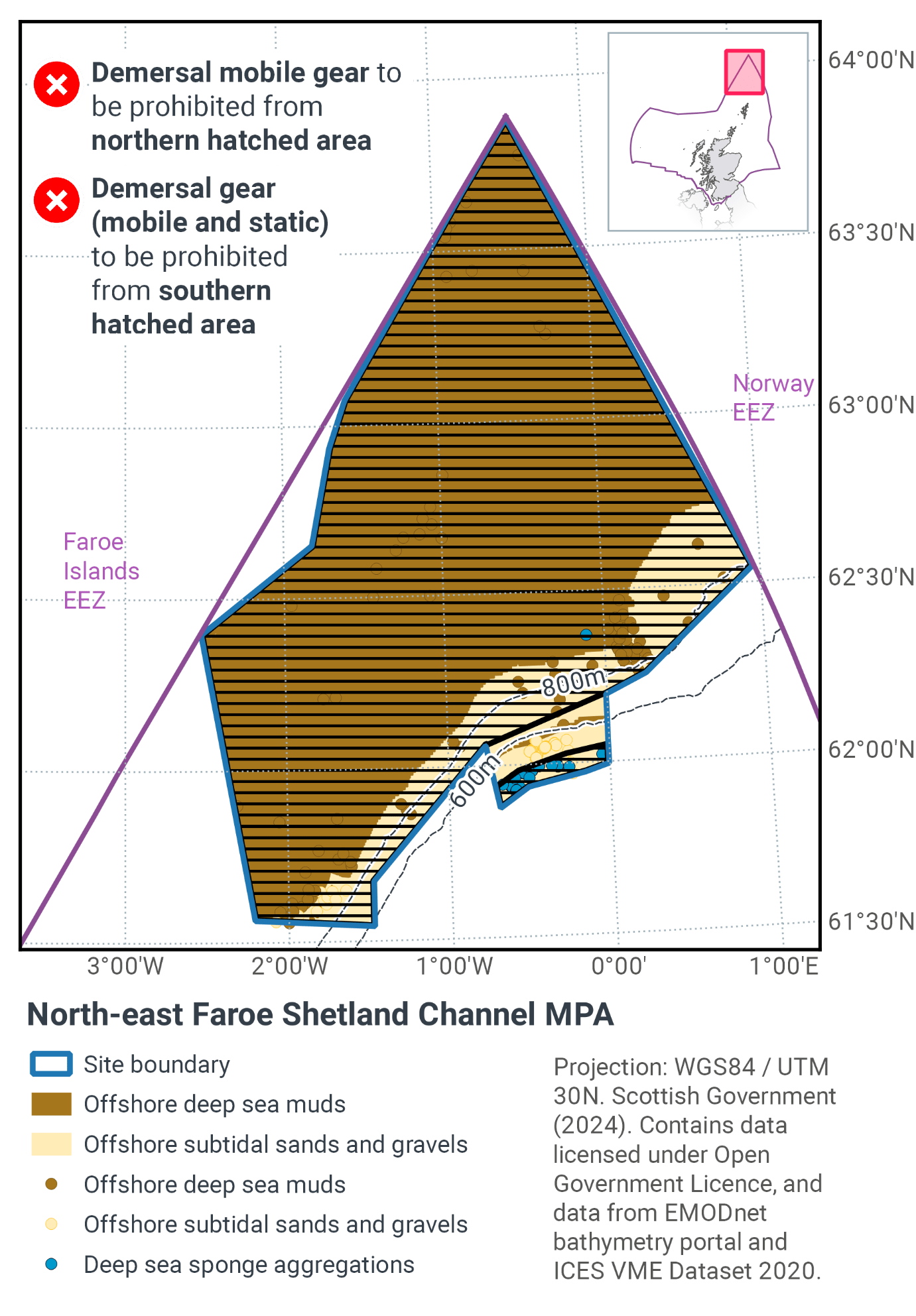
11.8 Proposed fisheries management and rationale
Table 17 and Figure 24 provides details of the proposed management approach and further explanation is provided below. Figure 25 shows the proposed fisheries management for full site prohibitions.
The geodiversity features are considered to have a low sensitivity to the pressures associated with marine activities taking place within the MPA . As such, JNCC considers there is no significant risk of the features not achieving their conservation objectives and so they have not been reported further in the context of the management options presented below. Further information is available within the MPA Management Options Paper.
(Table 17) Proposed management approach for Northeast Faroe-Shetland Channel MPA
Protected feature: Deep-sea sponge aggregations
Gear type: Demersal mobile
Gear type: Demersal static
Proposed management: Remove / avoid pressures
Proposed management: Reduce / limit pressure
Measures: Zonal exclusion of all demersal mobile and demersal static gears from where records of deep-sea sponge aggregations have been found.
Protected feature: Offshore sands and gravels and Deep-sea muds
Gear type: Demersal mobile
Proposed management: Reduce / limit pressure
Measures: Zonal exclusion of demersal mobile gears from depths greater than 700m.
Deep-sea sponge aggregations are considered to be a VME (FAO, 2009). They are sensitive to impact from all demersal fishing types (mobile and static). Therefore, there is no alternative to excluding all of these fishing methods from that part of the MPA.
Deep-sea sponge aggregations are also listed by OSPAR as being a threatened and /or declining species in the north-east Atlantic. These measures will make a contribution to recovery of these species. They should also further progress towards Good Environmental Status in the Greater North Sea, particularly in relation to Descriptors 1 (biological diversity) and 6 (sea-floor integrity).
For the deeper part of the site the accepted advice is to reduce or limit pressure. Currently there is no significant activity in this area. Therefore, the conclusion is to prevent pressure being exerted in the future. Crucially from a fisheries perspective this approach enables demersal mobile gear to still be used in a small but productive part of the MPA, without detriment to the known distribution of the protected features.
Contact
Email: marine_biodiversity@gov.scot
There is a problem
Thanks for your feedback