Fisheries Management Measures within Scottish Offshore Marine Protected Areas (MPAs) - Site Proposal Document
This document describes the process, justification and evidence used to develop site specific management measures. It outlines key information for each site including their features, and risks of potential pressures.
12. North-West Orkney
12.1 Description and background
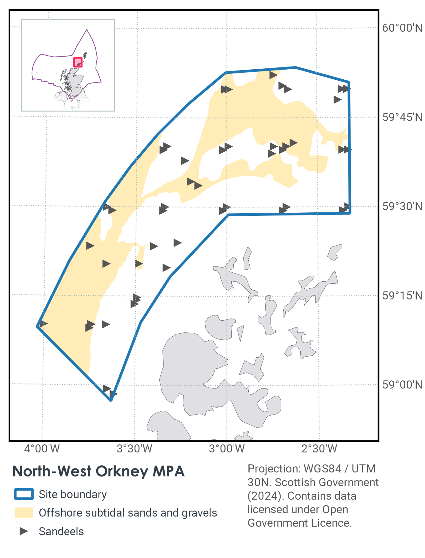
The North-west Orkney MPA lies to the north and west of Orkney and is considered an area important for sandeels (Figure 26). The MPA plays an important role in supporting wider populations of sandeels in Scottish waters. The area also encompasses several sand banks, and sand and sediment wave fields of geological importance. The area of the North-west Orkney MPA covers an area of approximately 4,365 km2.
The high density of emergent larvae and simulations of larval transport indicate this spawning area is an important source of larvae that populate sandeel grounds around Shetland and south to the Moray Firth (Proctor et al., 1998). Newly hatched sandeel larvae from this region are exported by currents to sandeel grounds around Shetland and the Moray Firth. The persistence of sandeels spawning in the area is evident from larval surveys ranging from 1950 (Langham, 1971; Proctor et al., 1998), through to 2005 (Lynam et al., 2013).
The MPA sits partially within the Fair Isle Strait Marine Process Bedforms Key Geodiversity Area and includes sediment wave fields, sand banks and sand wave fields representative of this Key Geodiversity Area (Brooks et al., 2013).
Further information can be found in the Site Information Centre.
12.2 Site features
The North-West Orkney MPA is designated for the following protected features:
- Sandeels
- Sand banks, sand wave fields and sediment wave fields representative of the Fair Isle Strait Marine Process Bedforms Key Geodiversity Area
Sandeels are considered to be a priority in terms of marine conservation in Scotland’s seas and appropriate for spatial management. The MPA makes a contribution to the MPA network for its sandeel population. The export of larval recruits also minimise the risk to the depletion of grounds around Shetland and south of the Moray Firth.
The geodiversity features representative of the Fair Isle Strait Marine Process Bedforms Key Geodiversity Area are regarded as scientifically important for the study of marine shelf processes and the relationship between currents, bed sediments and bed forms (Brooks et al., 2013).
12.3 Site Boundary
The boundary has been set in accordance with the boundary setting principles outlined in the MPA Selection Guidelines.
The MPA boundary encompasses a highly productive sandeel spawning ground based on the densities of newly emergent sandeel larvae recorded (Wright & Bailey 1996), which are an important source of recruits for export to adult populations in grounds around Shetland and south of the Moray Firth (Proctor et al., 1998).
12.4 Conservation Objectives
JNCC’s view on the overall condition of the site’s qualifying features is they are in favourable condition and therefore need to be maintained in favourable condition.
The Conservation Objective for the North-west Orkney Nature Conservation Marine Protected Area is that the protected features listed below –
- so far as already in favourable condition, remain in such condition; and
- so far as not already in favourable condition, be brought into such condition, and remain in such condition.
The full conservation advice documents can be found on the JNCC website. This includes the formal conservation advice for the site, background information and the full conservation objectives.
12.5 Pressure from demersal mobile fishing gear
The protected feature is not considered to be sensitive to pelagic/non-bottom contact gears or bottom-contact gears targeting other species with the exception of hydraulic dredging. The sensitivity of sandeels to hydraulic methods is likely to pose the greatest risk of all demersal mobile gear used in Scotland based on the extent to which they penetrate/disturb the sediment.
The larger mesh trawl and seine nets used to catch whitefish and nephrops do not generally catch sandeels and therefore are not expected to have any direct impact. The mixed ground type (areas of rough substrate within the areas of sediment suitable for sandeel colonisation) is also unsuitable for demersal trawling, meaning pressures arising from this gear which may impact the feature would not be exerted on the feature within the site. Further information on JNCCs wider advice in regards to sandeels can be found in the Sandeel Fisheries Management Guidance.
Shelf tidal bedform features such as these within the site are active, and are maintained under a specific range of tidal current conditions. As such, in the event that physical damage occurs, they are likely to be able to recover relatively quickly (Brooks, 2013). It is not thought that there are any activities taking place within or in proximity to the MPA that may alter tidal current conditions. Sediment wave fields, sand wave fields and sand banks are at low risk of damage by human activity across Scotland’s seas. Consequently, it is considered that the geodiversity protected features are unlikely to have been significantly modified by human activity.
12.6 Pressure from demersal static fishing gear
Sandeels are not caught by static gears and the impact of these gears is therefore considered to be minimal.
It is not thought that there are any activities taking place within or in proximity to the MPA that may alter tidal current conditions. Sediment wave fields, sand wave fields and sand banks are at low risk of damage by human activity across Scotland’s seas.
12.7 Levels of fisheries management considered
Although several different fisheries currently exist within the MPA, none of these fisheries are currently considered likely to affect the sandeel feature. Furthermore, targeted sandeel fishing is now prohibited within Scottish waters.
12.8 Proposed fisheries management and rationale
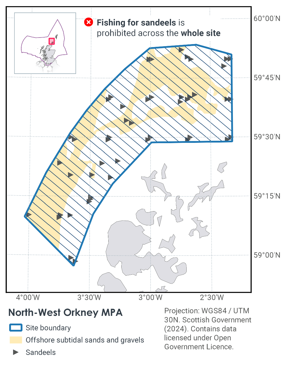
The Scottish Government, in line with JNCC advice, consider no additional management of fishing activity is necessary at the current time to achieve the conservation objective for the sandeel feature. Figure 27 shows the current prohibitions on fishing within North-West Orkney MPA. However, if monitoring showed evidence of detrimental effects to the protected feature as a result fisheries activity in the future, additional management may need to be considered.
On 31 January, the Cabinet Secretary for Rural Affairs, Land Reform and Islands announced that the Scottish Government would be proceeding with prohibiting fishing for sandeel in all Scottish waters. The Sandeel (Prohibition Of Fishing) (Scotland) Order 2024 came into force on 26 March 2024 ahead of the 2024 fishery season and applies to all vessels (EU and UK) fishing in these waters. The decision follows a detailed analysis of all responses and representations received to the 12-week consultation on this issue and which closed on 13 October 2023.
Sediment wave fields, sand banks and sand wave fields represent features under the Marine Geomorphology of the Scottish Shelf Seabed category, and are predominantly formed by the action of tidal currents. As long as current patterns and flow rates are maintained, these features are likely to be maintained over time, even if subject to physical disturbance. As such, JNCC do not consider there to be a significant risk of features not achieving their stated conservation objectives and so the features have not been considered further in the context of the management options presented below.
Contact
Email: marine_biodiversity@gov.scot
There is a problem
Thanks for your feedback