Fisheries Management Measures within Scottish Offshore Marine Protected Areas (MPAs) - Site Proposal Document
This document describes the process, justification and evidence used to develop site specific management measures. It outlines key information for each site including their features, and risks of potential pressures.
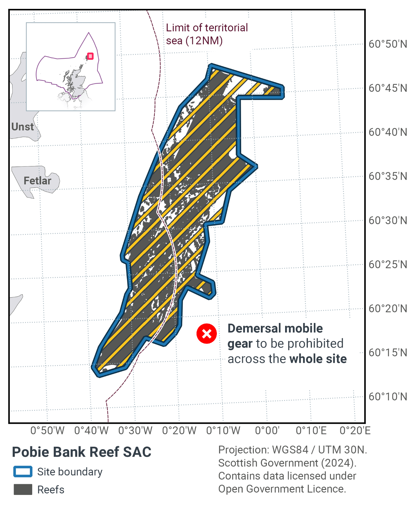
14. Pobie Bank Reef SAC
14.1 Description and background
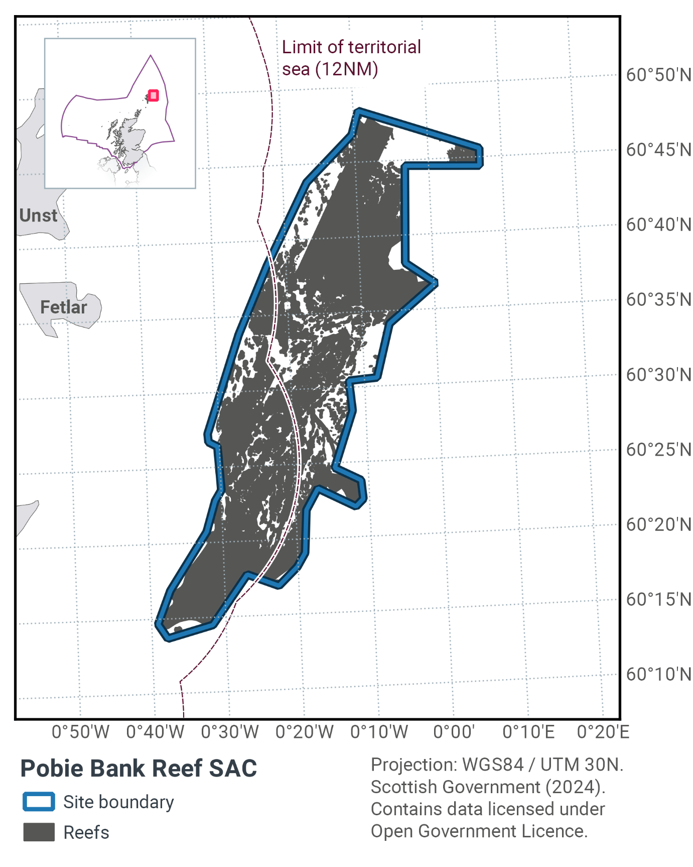
Pobie Bank Reef SAC is located in the North Sea, approximately 20 km east of Unst, Fetlar and Whalsay in Shetland and is separated from Shetland by the Unst Basin. The SAC, as shown in Figure 32 and Figure 34, is approximately 70 km long and 21 km wide. The depth within the SAC ranges from 70 m to over 100 m.
The reef is located on a bank of metamorphic and sedimentary rocks covered by a patchy veneer of sediment. Pobie Bank is a topographically complex area where the reef is composed of very large, rugged bedrock outcrops from areas of surrounding sandy sediment. These outcrops are generally surrounded by large boulders and cobbles in a sandy matrix. Towards the north and south of the reef, bedrock outcrops are smoother and integrated with extensive areas of stony reef.
Pobie Bank Reef SAC is designated for the Annex I habitat reefs, containing the subtypes of bedrock and stony reef. Bedrock reefs are made from continuous outcroppings of bedrock, including pinnacles, pavements, ridges and banks. They may also have a non-continuous, mobile veneer of sediment (Johnston et al. 2002). Stony reefs consistent of aggregations of boulders and cobbles, with finer sediments in-between. The stony reef definition was further clarified in the report by Irving (2009), which specified that stony reef should be topographically distinct from the surrounding sea floor, with ten percent or more of the seabed substratum composed of particles greater than 64mm across, i.e. cobbles and boulders, though this may be patchy in distribution.
The Annex I reef layer includes datasets from a wide range of different sources which were combined to produce the map of Annex I reefs in UK waters. Information on the methodology, and which EUNIS codes are included within each reef subtype is available from JNCC (2013). The Annex I Reef layer for Pobie Bank Reef SAC has been informed by multiple surveys, including from 2013. The development of the management proposal for the site is based on the 2013 survey, which collected ground truth and high resolution multibeam data for four areas within the site to better ascertain the distribution of bedrock and stony reef. This data provided updated information on the extent of, and confidence in Annex I reef in the site.
The reef provides a habitat to an extensive community of encrusting and robust sponges and bryozoans. In the shallowest areas, the bedrock and boulders also support encrusting coralline algae. Axinellid cup sponges (Axinella infundibuliformis) are common on the bedrock and stony reef at depth ranges of 70 m to over 100 m. The bryozoan Omalosecosa ramulosa is also common on these reefs, and is rare in inshore sites in this regional sea. In the deepest areas (>100 m), low-lying silty bedrock is commonplace, supporting small erect sponges, cup corals (Caryophyllia smithii) and the brittlestar Ophiura albida (Figure 33).
Further information can be found in the Site Information Centre.
14.2 Site Features
The Pobie Bank Reef MPA is designated for the following protected features:
- Bedrock and stony reef (Annex I Reefs).
Pobie Bank Reef SAC is contributed to the MPA Network for Annex I reef habitat. It represents an excellent and extensive example of hard bedrock and stony reef of medium to high topographic complexity, in deep circalittoral waters. Designation of this SAC increased the geographic range of representation of this habitat type in the UK Network.
The total area of the SAC is 966 km2 with 648 km2 of reef feature, the reef components are shown in Table 20.
Annex I Reef type |
Area of habitat within SAC (km2) |
|---|---|
Bedrock |
235.23 |
Stony |
107.26 |
Bedrock and stony |
305.21 |
Total |
647.70 |
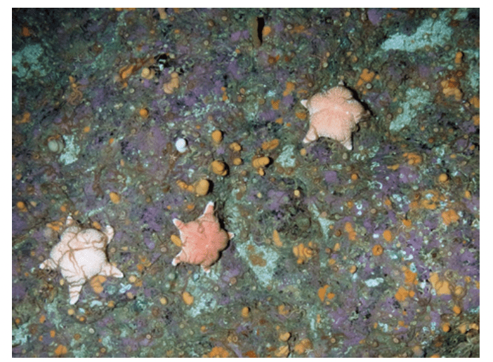
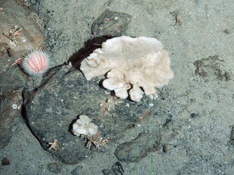
Figure 33. Feature images from Pobie Bank Reef SAC, showing a) cushion stars (Hippasteria phrygiana) on bedrock with encrusting coralline algae (Corallinaceae), dead man's fingers (Alcyonium digitatum) and brittle stars (Ophiothrix fragilis), and b) sponge (Phykellia sp.) and the sea urchin (Strongylocentrotus droebachiensis) on a cobble © JNCC/Cefas
14.3 Site Boundary
The boundary for Pobie Bank Reef SAC has been defined using the JNCC marine SAC boundary definition guidelines (JNCC, 2012a). It is a relatively simple polygon enclosing the minimum area necessary to ensure protection of the Annex I habitat. The site boundary includes a 300 m buffer around the reef habitat which is three times the maximum reef depth of 100 m. The Annex I reef feature was interpreted from acoustic and ground truth data collected during surveys in 2003 and 2006. Areas of lowest data confidence were excluded from the site.
14.4 Conservation objectives
JNCC’s view on the overall condition of the site’s qualifying feature is uncertain due to insufficient evidence to determine the condition status.
The conservation objective for Pobie Bank Reef SAC is to, subject to natural change, maintain/restore the reef at/to favourable condition, such that:
- the natural environmental quality and processes supporting the habitat,
- the extent of the habitat on site, and
- the physical structure, community structure , function, diversity and distribution of the habitat and typical species representative of the reef in the Northern North Sea regional sea
are maintained or restored, thereby ensuring the integrity of the site and also making an appropriate contribution to favourable conservation status of the Annex 1 reef habitat.
The full conservation advice documents can be found on the JNCC website. This includes the formal conservation advice for the site, background information and the full conservation objectives.
14.5 Pressure from demersal mobile fishing gear
Whilst it is unlikely that demersal mobile gear can affect the long-term natural distribution of bedrock and stony reef features, there is evidence to indicate that the use of demersal mobile gears can impact the structure and function of the habitat and the long-term survival of its associated species.
The use of demersal mobile fishing gears is likely to cause damage or death of fragile, erect species, such as sponges and corals through abrasion and siltation/smothering pressures (Freese et al., 1999; Løkkeborg, 2005). Other species such as hydroids, anemones, bryozoans, tunicates and echinoderms may also be vulnerable (McConnaughey et al., 2000; Sewell & Hiscock, 2005). Where fragile, slow growing species occur, even low levels of fishing have the potential to change the structure and function of the habitats and may result in the loss of some characteristic species.
14.6 Pressure from demersal static fishing gear
Mechanical impacts of static gear (e.g. weights and anchors hitting the seabed, hauling gear over seabed, rubbing/entangling effects of ropes) can damage some species (Eno et al., 1996). Other species appear to be resilient to individual fishing operations, but the effects of high fishing intensity are unknown (Eno et al., 2001). Recovery will be slow (Foden et al., 2010) resulting in significant reduction or even loss of characteristic species. The individual impact of a single fishing operation may be slight but cumulative damage may be significant (Eno et al., 2001; Foden et al., 2010).
14.7 Levels of fisheries management considered
Table 21 provides a summary of the management advice from JNCC set out against the various options that have been considered.
(Table 21) Summary of fisheries management advice for Pobie Bank Reef MPA
Fisheries management options considered for demersal mobile gear
No additional management: There is a significant risk of not achieving the conservation objectives for the reef features.
Reduce / limit pressures: This level of management would reduce the risk of not achieving the conservation objectives for the reef feature. Appropriate management could include exclusion of demersal gears over the main areas of bedrock and stony reef, allowing fishing to continue in fishable areas around the features. There may be some locations where reef presence is unknown or uncertain, and there would therefore be a risk of localised damage to the structure and function of reef communities in these areas. The location of areas to be covered by management restrictions would include a buffer zone to reduce any risk of accidental contact with the feature.
Remove / avoid pressures: This level of management would reduce the risk of not achieving the conservation objectives for the reef feature to the lowest possible levels. Restrictions would be required for all demersal mobile gears within the full extent of the site boundary. The site boundary already includes a buffer zone based on a ratio of 3:1 fishing warp length to depth around the known features to reduce any risk of accidental contact with the feature.
Fisheries management options considered for demersal static gear
No additional management: This level of management is considered to be sufficient for demersal static gear, to achieve the conservation objectives for the reef feature. However, if static gear fishing intensity increased or monitoring showed evidence of detrimental effects, it may be necessary to apply limits in the future.
Reduce / limit pressures: This level of management would further reduce the risk of not achieving the conservation objectives for the reef feature. However, if static gear fishing intensity increased or monitoring showed evidence of detrimental effects, it may be necessary to apply limits in the future where appropriate management could include partial closure of the feature and/or limits on the amount of gear that can be deployed.
14.8 Proposed fisheries management and rationale
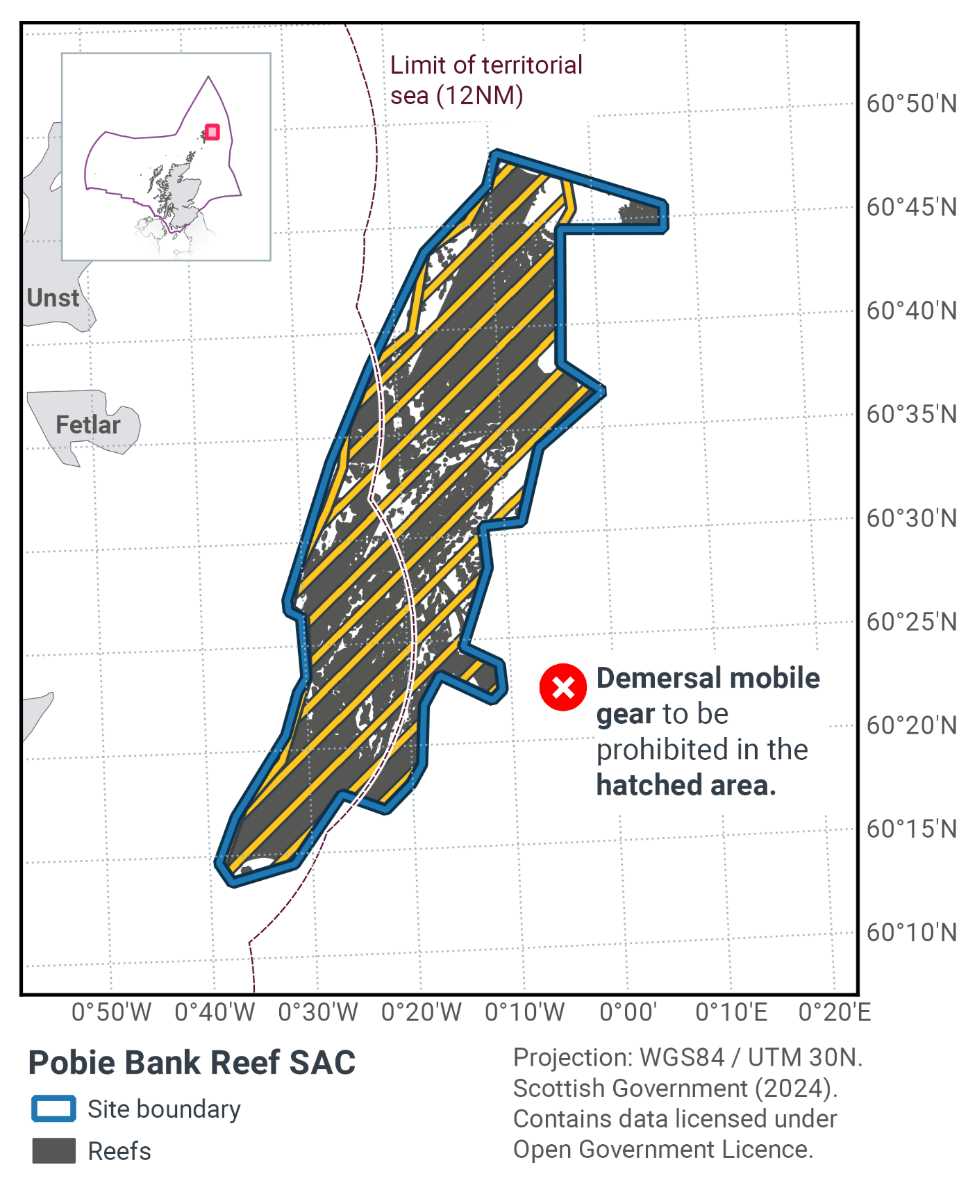
Table 22 and Figure 34 provides details of the proposed management approach and further explanation is provided below. Figure 35 shows the proposed fisheries management for full site prohibitions.
Protected feature |
Gear type |
Proposed management |
Measures |
|---|---|---|---|
Bedrock and Stony reef |
Demersal mobile gear |
Remove / avoid pressures |
Prohibit all demersal mobile gear fisheries from 98.51% of the reef habitat |
Demersal static gear |
No additional management |
No demersal static gear measures applied |
The management boundary has been drawn closer to the reef feature than the SAC boundary. At the stakeholder workshop it was evident that vessels tow their gear parallel to the reef meaning gear width is the determining metric rather than water depth / warp length. The amount of reef that will be exposed to fishing pressure is insignificant when compared to the scale of the habitat within this SAC. Table 23 shows the percentages of habitat protected from mobile gear to be 98% from the proposed zonal fisheries management measures.
The management measures will contribute to achieving favourable conservation status for Annex I reef in the Atlantic marine region. They should also further progress towards Good Environmental Status in the Greater North Sea, particularly in relation to Descriptors 1 (biological diversity) and 6 (sea-floor integrity).
Annex I Reef habitat type |
Habitat within SAC (km2) |
Habitat within management zone (km2) |
% habitat protected from demersal mobile gear |
|---|---|---|---|
Bedrock |
235 |
235 |
100 |
Stony |
107 |
98 |
92 |
Bedrock and stony |
305 |
305 |
100 |
Total |
647 |
638 |
99 |
Contact
Email: marine_biodiversity@gov.scot
There is a problem
Thanks for your feedback