Fisheries Management Measures within Scottish Offshore Marine Protected Areas (MPAs) - Site Proposal Document
This document describes the process, justification and evidence used to develop site specific management measures. It outlines key information for each site including their features, and risks of potential pressures.
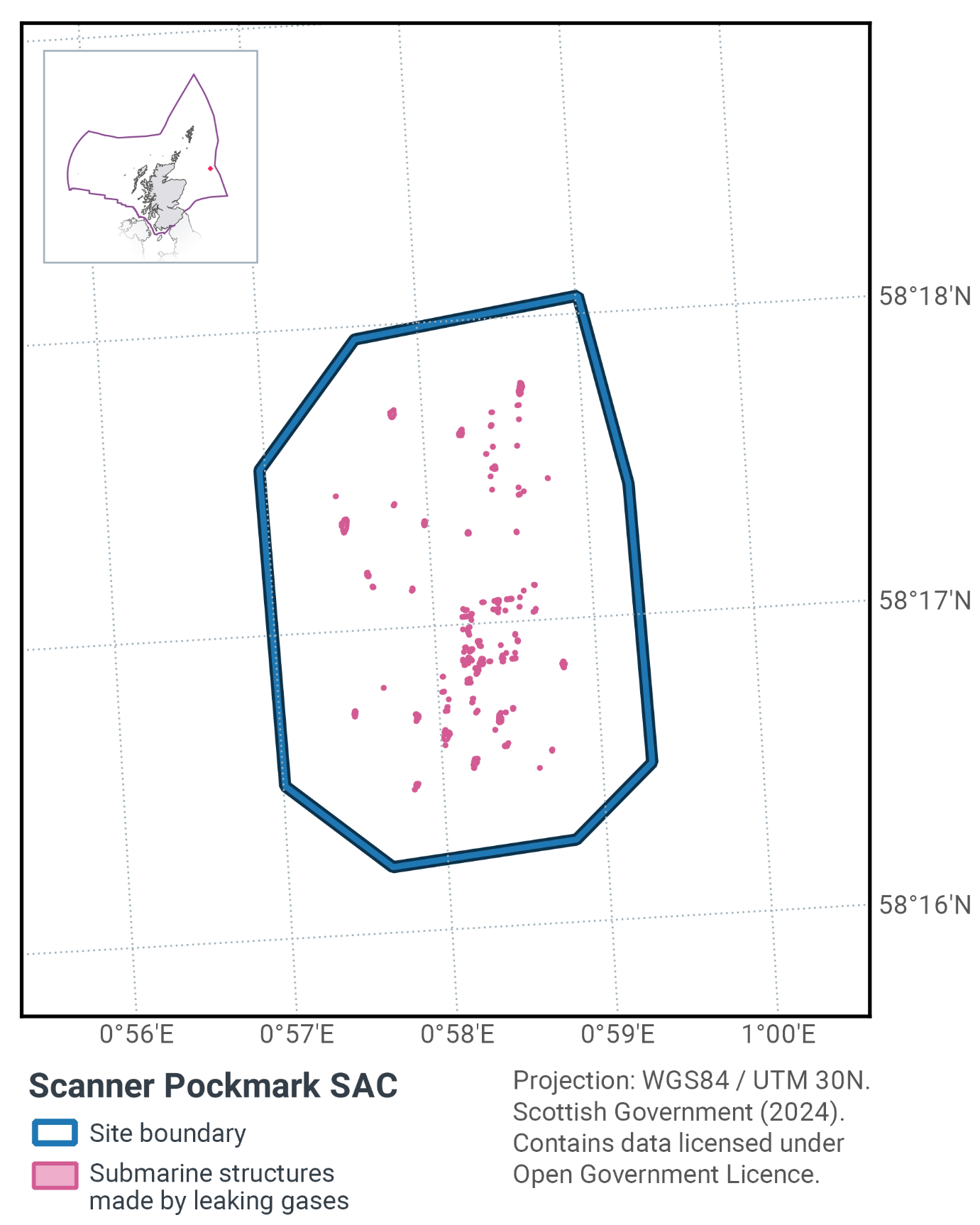
15. Scanner Pockmark SAC
15.1 Description and background
The Scanner Pockmark SAC contains 61 pockmarks of varying sizes. Four of these are unusually large and occur in two pockmark complexes; Scanner and Scotia. The SAC itself is just 3 km2 in area, as shown in Figure 36 and Figure 38.
The pockmarks were created by the expulsion of shallow methane gas and have been maintained by active gas seepage. At the base of the pockmarks, blocks of ‘methane derived authigenic carbonate’ (MDAC) have been recorded. These carbonate rocks, formed by the precipitation of calcium carbonate and cementation of the surrounding sediment, have been identified as the Annex I habitat ‘submarine structures made by leaking gases’ (Habitats Directive feature H1180).
There is some evidence of chemosynthetic bacteria in the Scanner Pockmark SAC, which grow by oxidising sulphur and may support some of the site’s other notable fauna. The most important species present from a conservation perspective is the gutless nematode Astomonema southwardorum, which may derive some of its nutrition from chemosynthetic bacteria (Austin et al., 1993). Other important species associated with the gas seepage in the pockmark are the bivalves Thyasira sarsi and Lucinoma borealis.
The presence of carbonate structures formed from leaking gases was confirmed by survey using ROV (remotely operated vehicle), but the location and extent of carbonate blocks has not been precisely mapped. The latest survey data indicates the location of all pockmarks within the site and further locations where there could be MDAC or other hard substrate types on the seafloor (Figure 37; Gafeira & Long, 2015).
Further information can be found in the Site Information Centre.
15.2 Site Features
The Scanner Pockmark SAC is designated for the following features:
- Submarine structures made by leaking gases.
The Scanner Pockmark SAC is in the northern North Sea, and represents the Annex I feature submarine structures made by leaking gases (H1180) in the UK Sites network. The faunal communities are representative of those present on submarine structures made by leaking gases, consisting principally of anemones (Bolocera tuediae, Urticina felina and Metridium senile), as well as chemosynthetic organisms (Dando et al., 1991). However, the morphology of the carbonate structures is fairly homogenous and the habitat is not especially extensive at the base of the pockmark. There are two pockmark complexes within the site, known as Scanner and Scotia.
The Scanner pockmark complex comprises two large pockmarks with a combined area of approximately 0.32 km2 and depths of up to 16m below the surrounding sea floor. These pockmarks have a considerably greater volume than more typical pockmarks in the vicinity of the site.
The Scotia pockmark complex is formed by the Northern Scotia pockmark (approximately 0.076 km2 in size with a depth of 12m below the level of the surrounding seabed) and the Southern Scotia pockmark (least 0.072 km2 with a depth of 14.5 m). Numerous surveys since the 1990s have found evidence for the active seepage of methane in this complex, but the location and extent of carbonate blocks has not been precisely mapped.
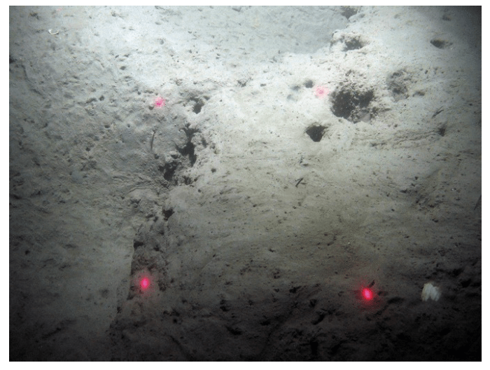
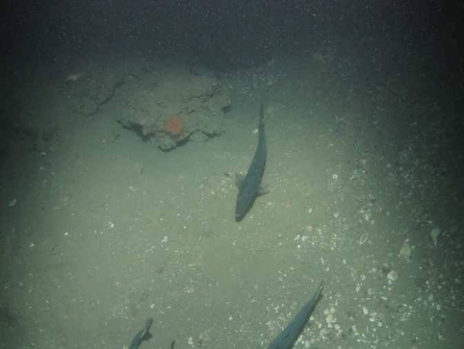
Figure 37: Images representing a) Nephrops (Nephrops norvegicus) burrows in soft sediment within the Scanner Pockmark SAC ©JNCC/Cefas. Image b) is representative of the submarine structures formed by leaking gases, showing methane derived authigenic carbonate protruding from sediment with a colourful anemone (Urticina sp.) ©JNCC/Cefas
15.3 Site Boundary
The site was defined using the JNCC marine SAC boundary definition guidelines (JNCC, 2012a). The boundary was drawn around the known extent of the pockmarks at the time in a simple polygon. The site area was 3.35 km2 when designated and comprised a simple polygon to encompass known records of submarine structures made by leaking gases in the vicinity.
A survey of the site, conducted in 2012 and commissioned by JNCC, discovered a further 6 pockmarks outside the original site boundary. An amendment to the site boundary for Scanner Pockmark SAC to encompass these features and including a buffer of 495 m measured from the edge of the pockmark depression (this equates to three times the maximum water depth of 165 m) was consulted on in 2017 and approved and submitted to the European Commission in September 2018.
15.4 Conservation objectives
JNCC’s view on the overall condition of the site’s qualifying feature is that it is in unfavourable condition noting it is not considered feasible to restore some of the feature’s attributes using management intervention.
For the feature to be in favourable condition thus ensuring site integrity in the long term and contribution to Favourable Conservation Status of Annex I Submarine structures made by leaking gases.
This contribution would be achieved by maintaining or restoring, subject to natural change:
- The extent and distribution of the qualifying habitat in the site;
- The structure and function of the qualifying habitat in the site; and
- The supporting processes on which the qualifying habitat relies.
The full conservation advice documents can be found on the JNCC website. This includes the formal conservation advice for the site, background information and the full conservation objectives.
15.5 Pressure from demersal mobile fishing gear
Direct evidence of impacts of demersal mobile gears to submarine structures made by leaking gasses is limited. However, the biological communities that develop on exposed structures typically include many of the same species that can be found on subtidal rocky habitats in similar environmental conditions, and it is likely that the effects of fishing will be similar.
The use of demersal mobile fishing gears is likely to cause damage or death of fragile, erect species, such as sponges and corals (Freese et al., 1999; Løkkeborg, 2005). Other species such as hydroids, anemones, bryozoans, tunicates and echinoderms are vulnerable to mobile fishing gear (McConnaughey et al., 2000; Sewell & Hiscock, 2005). Recovery is likely to be slow (Foden et al., 2010). Where fragile, slow growing species occur, even low levels of fishing have the potential to change the structure and function of the habitats and may result in the loss of some characteristic species.
15.6 Pressure from demersal static fishing gear
There is no direct evidence from which to determine impacts of demersal static gears on submarine structures made by leaking gases. However, the biological communities that develop on exposed structures typically include many of the same species that can be found on subtidal rocky habitats in similar environmental conditions, and it is likely that the effects of fishing will be similar.
Mechanical impacts of static gear (e.g. weights and anchors hitting the seabed, hauling gear over seabed, rubbing/entangling effect of ropes) can damage some species (Eno et al., 1996). Other species appear to be resilient to individual fishing operations, but the effects of high fishing intensity are unknown (Eno et al., 2001). Recovery may be slow, resulting in significant reduction or even loss of characteristic species (Foden et al., 2010). The individual impact of a single fishing operation may be slight but cumulative damage may be significant (Eno et al., 2001; Foden et al., 2010).
15.7 Levels of fisheries management considered
Table 24 provides a summary of the management advice set out against the various options that have been considered.
(Table 24) Summary of fisheries management advice for Scanner Pockmark SAC
Fisheries management options considered for demersal mobile gear
No additional management: There is a significant risk of not achieving the conservation objectives for the submarine structures made by leaking gases.
Reduce / limit pressures: This level of management would reduce, but not entirely eliminate, the risk of degradation to the submarine structures made by leaking gases feature as a result of direct impact from fishing activities. Appropriate management could include closure of the known extent of the feature within the site. However, a risk of impact with patches of feature not identified during survey would remain. As current evidence suggests that the feature is not exposed, the risk of damage to the feature is likely to be highest for heavy gear components thus restrictions may be appropriate for these gears. Areas to be covered by management restrictions would include a buffer zone around the known features equal to three times the water depth to reduce any risk of accidental contact with the feature.
Remove / avoid pressures: This level of management would reduce the risk of degradation to any submarine structures made by leaking gases feature within the site boundary to the lowest possible levels. Due to the potential for re-exposure of feature, restrictions would be required for all demersal mobile gears within the full extent of the site boundary. The boundary already includes a buffer zone around the known features equal to three times the water depth to reduce any risk of accidental contact with the feature.
Fisheries management options considered for demersal static gear
No additional management: The risk of deterioration of the submarine structures made by leaking gases from demersal static gears is considered minimal. This level of management is considered appropriate for all demersal static gears. However, if static gear fishing were to increase and monitoring showed evidence of detrimental effects, it may be necessary to apply restrictions in the future.
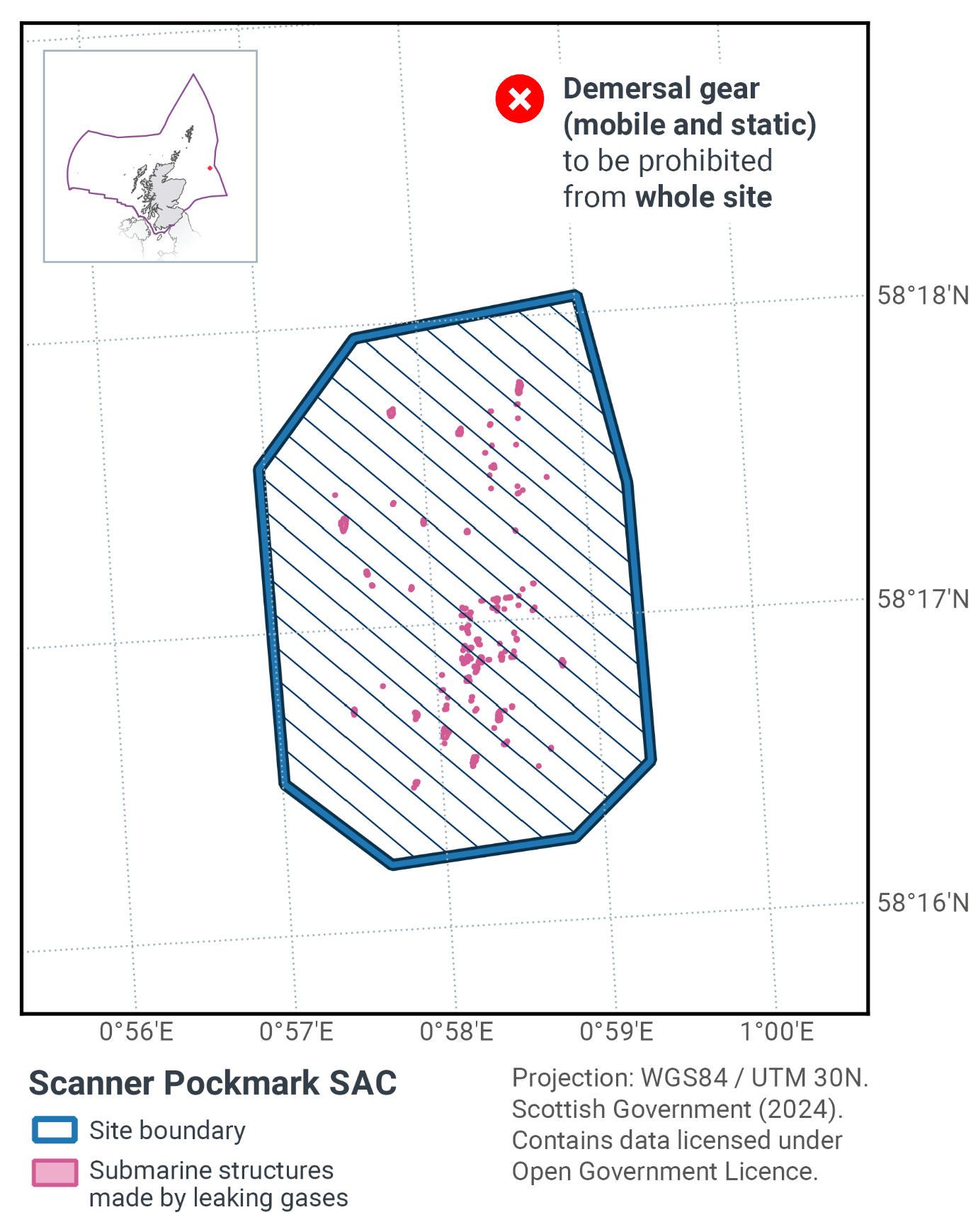
15.8 Proposed fisheries management and rationale
Table 25 and Figure 38 provide details of the proposed management approach and further explanation is provided below.
Protected feature |
Gear type |
Proposed management |
Measures |
|---|---|---|---|
Submarine structures made by leaking gases |
Demersal mobile |
Remove / avoid pressures |
Prohibit all demersal mobile fisheries from the SAC. |
Demersal static |
Remove / avoid pressures |
Prohibit all demersal static fisheries from the SAC. |
The submarine structures are in effect irreplaceable. If the carbonate substrate was damaged or removed from the site, then recovery would be virtually impossible. Therefore, the risk of fishing impact has to be reduced to the lowest possible level.
Management measures are proposed for demersal mobile gears to remove the risk to achieving the conservation objective posed by these gears. In addition, while the risk to achieving the conservation objective posed by demersal static gears is considered minimal, the scale of this site means that control and enforcement of fishing activity within the SAC would be very difficult. Therefore, the practical approach is to prohibit all demersal mobile and demersal static gears across the whole SAC; thereby limiting this site to single management proposal.
The measures should also help to improve the status of the seapens and burrowing megafauna Threatened and/or Declining habitat in OSPAR region II through its incidental protection as these are found in the immediate area surrounding the submarine structures (JNCC, 2018). They should also further progress towards Good Environmental Status in the Greater North Sea, particularly in relation to Descriptors 1 (biological diversity) and 6 (sea-floor integrity).
Contact
Email: marine_biodiversity@gov.scot
There is a problem
Thanks for your feedback