Fisheries Management Measures within Scottish Offshore Marine Protected Areas (MPAs) - Site Proposal Document
This document describes the process, justification and evidence used to develop site specific management measures. It outlines key information for each site including their features, and risks of potential pressures.
18. Darwin Mounds SAC
18.1 Description and background
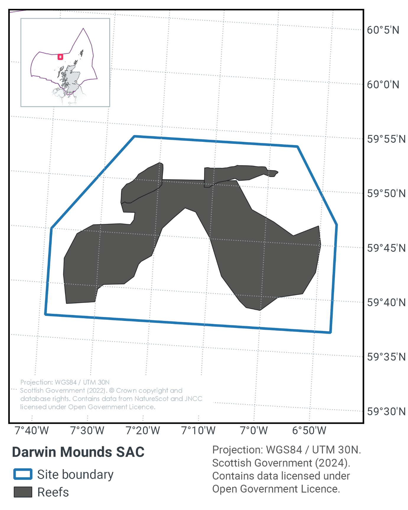
The Darwin Mounds SAC is located approximately 160 km north-west of Cape Wrath, Scotland, at the north end of the Rockall Trough, as shown in Figure 45. The site depth varies from 710 m to 1,129 m and consists of a large number of coral-topped 'sand volcanoes' composed of sand overlying mud. The individual mounds are up to 75 m wide and 5 m high and are morphologically unique in UK waters. The mounds themselves are unusual geological features that are thought to have been formed by fluid expulsion from the seabed. The mounds are most elevated to the north of the site and diminish in height to the south. There are two denser regions of mounds in the north-east and north-west of the site. The north-east field of the Darwin Mounds SAC measures approximately 13 km by 9 km and contains approximately 150 mounds, whereas the north-west field measures approximately 13 km by 4 km and contains approximately 75 mounds.
The mounds in the northern part of the site showed an acoustic signature of a "tail" which generally lies to the south-west of the mound feature consisting of elongate to oval patches up to 500 m long. The 'tail' feature of the mounds is thought to be unique globally. The tails are not topographically distinct from the surrounding seabed but are covered with a fine veneer of sand.
Further information can be found in the Site Information Centre.
18.2 Site Features
The Darwin Mounds SAC is designated for the following protected feature:
- Stony, bedrock and biogenic reefs (Annex I Reefs).
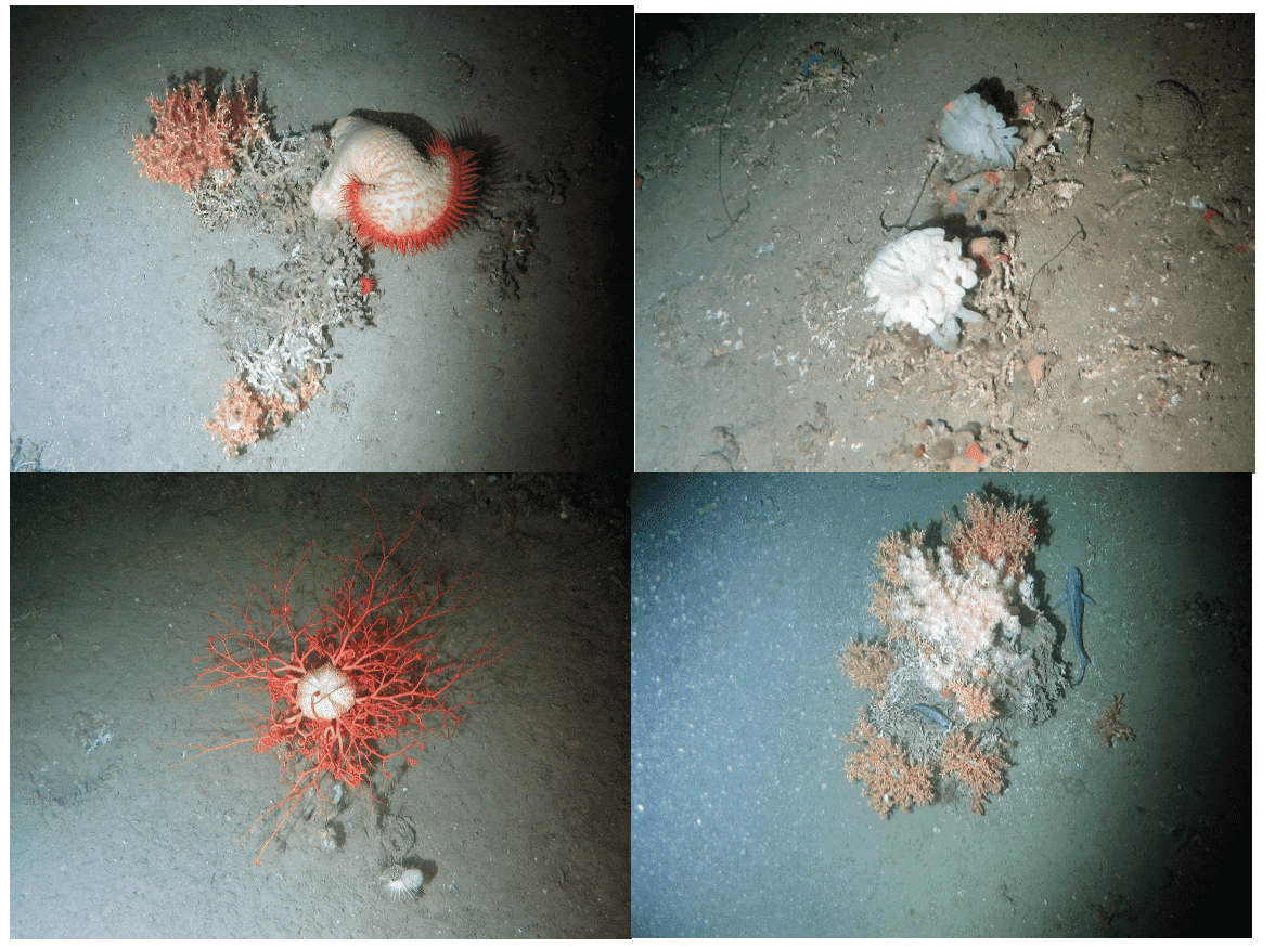
The tail feature of the mounds supports substantial numbers of the xenophyophore Syringammina fragilissima (a single-celled organism that can grow up to 20 cm in diameter), in densities greater than the surrounding seabed.
On the majority of the mounds there are also multiple colonies of Lophelia pertusa growing Figure 46, which in many cases have formed thickets which arise from the surface of the mound. This site was the first observed record of cold-water coral reefs growing on sand at the time of discovery. Like the topography of the mounds, the frequency of coral communities diminishes towards the south of the mound field. Although the reef habitat on top of the mounds is formed primarily from Lophelia pertusa, another cold-water coral – Madrepora oculata – is also present. The thickets of cold-water corals provide a habitat for echiuran worms, brittlestars, brisingiid starfish and sponges. Various fish have been observed among the mounds, but not at higher densities than the wider environment.
18.3 Site Boundary
The boundary of the Darwin Mounds SAC is a simple polygon, fully enclosing the minimum area necessary to ensure protection of the Annex I feature. The boundary has been aligned with the area permanently closed to bottom trawling by Common Fisheries Policy and Animals (Amendment etc.) (EU Exit) Regulations 2019 (S.I. 2019, No. 1312)
As bottom trawling is a significant threat to the feature of interest, the proposed boundary includes a margin to ensure its protection. The maximum depth of water around the feature is 1,000–1,100 m. Fishing vessels which are bottom trawling in the region need a minimum towline length of twice the depth of water in which they are fishing. Assuming a ratio of 2:1 fishing warp length to depth, the proposed boundary is defined to include a margin of 2,200 m from the cold-water coral reefs.
18.4 Conservation objectives
JNCC’s view on the overall condition of the site’s qualifying feature is that it is in unfavourable condition and therefore needs to be restored to favourable condition.
The conservation objective for the Darwin Mounds SAC are for the feature to be in favourable condition thus ensuring site integrity in the long term and contribution to Favourable Conservation Status of Annex I Reefs.
The full conservation advice documents can be found on the JNCC website. This includes the formal conservation advice for the site, background information and the full conservation objectives.
18.5 Pressure from demersal mobile fishing gear
Demersal mobile gears reduce the long-term natural distribution of cold water coral (biogenic reef) features, as well as impacting the structure and function of the habitat and the long term survival of its associated species. The passage of mobile fishing gear may increase mortality of the coral by crushing, burying or wounding corals, increasing susceptibility to infection and epifaunal recruitment that may eventually smother corals (Fosså et al., 2002).
The passing of a heavy trawl reduces the three-dimensional structure of the coral to rubble, decreasing the complexity of the habitat with impacts on the associated community composition (Koslow et al., 2001; Fosså et al., 2002). Indirect impacts on cold water coral reefs from trawling are from increased levels of suspended particles in the water column causing smothering and polyp mortality (Larsson & Purser, 2011).
Given the slow growth rate of the reefs, they may take centuries to recover from damage, if at all (ICES, 2010).
18.6 Pressure from demersal static fishing gear
Demersal static gears are likely to reduce the long-term natural distribution of cold water coral (biogenic reef) features, as well as impacting the structure and function of the habitat and the long term survival of its associated species. The impacts are considered to be lower than for demersal mobile gear types (Pham et al., 2014), however impacts to habitats and biota may occur during certain conditions. For example, hooks, lines, nets and ropes entangle corals and may pluck them during hauling (Grehan et al., 2004; ICES, 2010, Sampaio et al., 2012). Physical damage to the seabed has been observed which may be caused by dragged anchors (Grehan et al., 2004; ICES, 2010). The individual impact of a single fishing operation may be slight but cumulative damage can be significant. Given the slow growth rate of the reefs, they may take centuries to recover from damage, if at all (ICES, 2010).
18.7 Levels of fisheries management considered
As existing legislation fulfils the management criteria, (see 17.9), these measures (a full site closure to all demersal mobile and demersal static gears) will remain the same and will be taken forward into a the relevant order for this site. No additional advice is required as the current measures suffice.
18.8 Other fisheries measures which apply to the site
Existing management measures in place within Darwin Mounds SAC were implemented through the technical regulations process. An emergency fisheries closure for demersal towed gear under Regulation (EC) 602/2004 was introduced at the site in August 2003 to protect deep-water coral reefs. In March 2004, this became a permanent fisheries closure for demersal towed gear and has since been implicitly repealed and replaced by an SAC designation in 2008, and Regulation (EU) 2019/1241, protecting sensitive habitats including VMEs. This regulation prohibits the deployment of any bottom trawl or similar towed nets across the full area of the site.
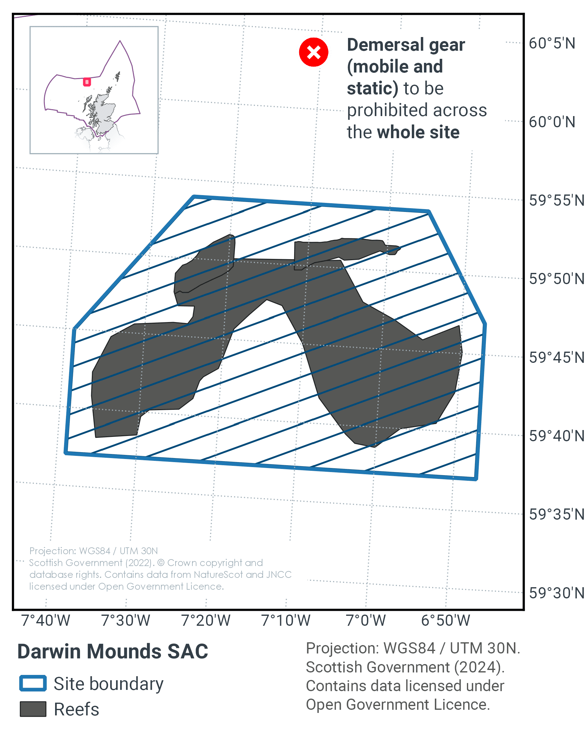
18.9 Proposed fisheries management and rationale
Table 30 and Figure 47 provide details of the proposed management option and further explanation is provided below.
Protected feature |
Gear type |
Proposed management |
Measures |
|---|---|---|---|
Stony, bedrock and biogenic reef |
Demersal mobile |
Remove / avoid pressures |
Prohibit all demersal mobile and static gears from the SAC |
Demersal static |
Remove / avoid pressures |
Prohibit all demersal static gears from the SAC |
The presence of biogenic reef with the site means that the measures need to manage both demersal mobile and static fishing gears. These measures will help improve the conservation status of Annex I reef in the Atlantic marine biogeographic region.
In addition the measures will also contribute to the recovery of Lophelia pertusa, listed by OSPAR as Threatened and/or Declining habitat in OSPAR region V. They should also further progress towards Good Environmental Status in the Celtic Seas, particularly in relation to Descriptors 1 (biological diversity) and 6 (sea-floor integrity).
Contact
Email: marine_biodiversity@gov.scot
There is a problem
Thanks for your feedback