Fisheries Management Measures within Scottish Offshore Marine Protected Areas (MPAs) - Site Proposal Document
This document describes the process, justification and evidence used to develop site specific management measures. It outlines key information for each site including their features, and risks of potential pressures.
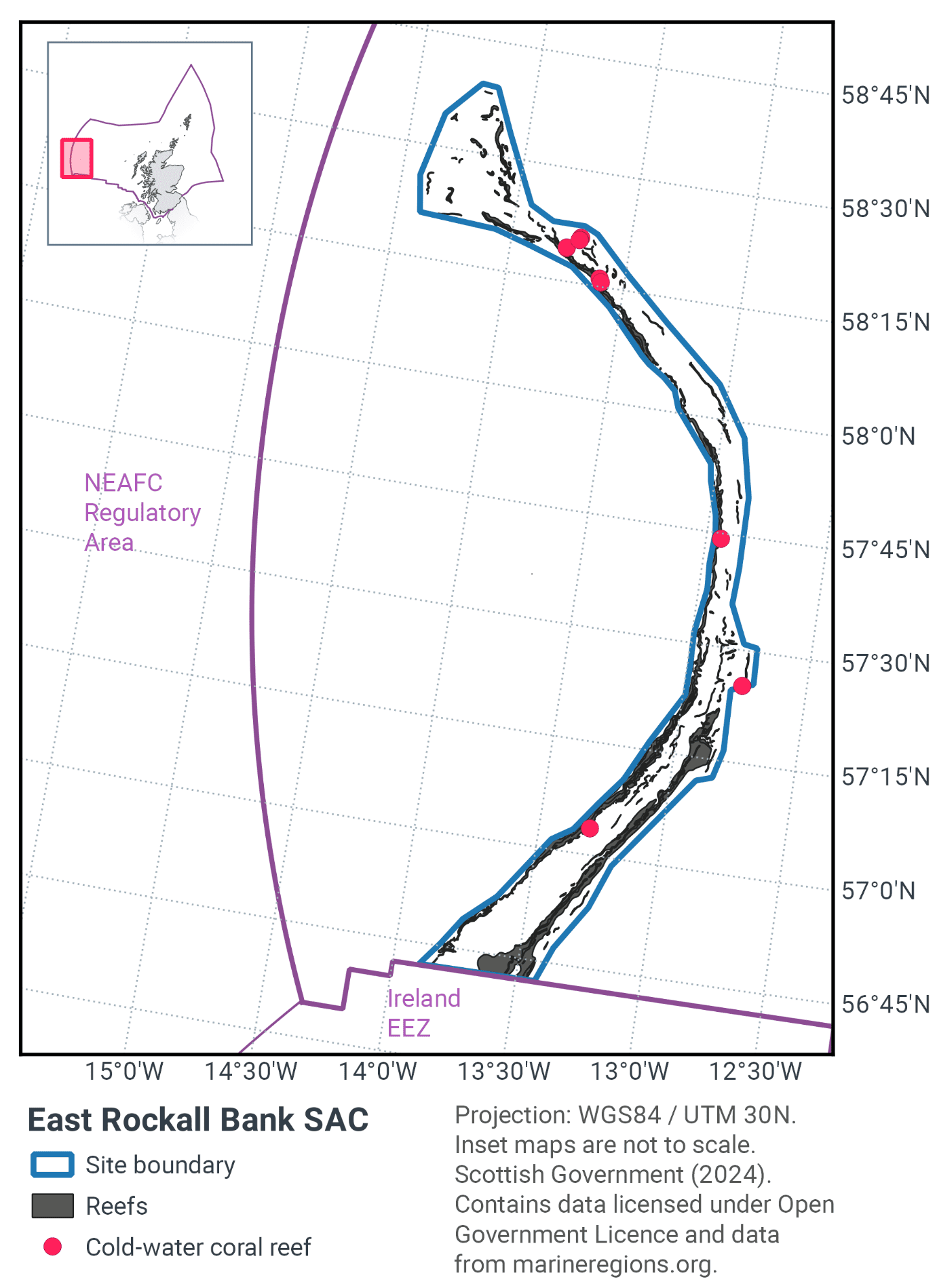
19. East Rockall Bank SAC
19.1 Description and background
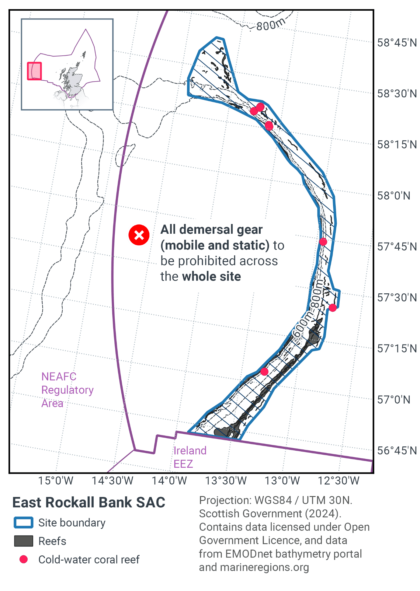
East Rockall Bank SAC is located about 320 km west of the Outer Hebrides on the West coast of Scotland, as shown in Figure 48. The site runs along the eastern flank of Rockall Bank, a geological feature approximately 450 km long and 200 km wide, orientated northeast to southwest, ranging in depth from 0 m (where a rocky ‘island’ outcrop breaks the surface) to 1000 m (Howell et al., 2009). The eastern edge of Rockall Bank forms a scalloped faulted scarp slope, which descends steeply down into the Rockall Trough at around 1000 to 1500 m water depth (Howell et al., 2009; Long et al., 2010).
The site comprises steep slopes, mixed substrates of boulder, cobbles and pebbles with areas of exposed bedrock and bedrock outcrop, with no one habitat type dominating (Howell et al., 2009).
The site represents a range of Annex I reef subtypes - hard bedrock reef of low topographic complexity, stony, and biogenic Lophelia pertusa reef in the deep circalittoral to bathyal zone. Therefore the site makes a contribution to the UK Network.
Further information can be found in the site information centre.
19.2 Site Features
The East Rockall Bank SAC is designated for the following protected features:
- Stony, bedrock and biogenic reefs (Annex I Reefs).
Bedrock and stony reef along a steep cliff feature supports stylasterid corals and lobose and encrusting sponges. This habitat has not been observed elsewhere within the UK continental shelf, likely due to the depth of the feature which is shallower than most other deep sea structures (Long et al., 2010). Sediment in-filled dead Lophelia pertusa framework representing biogenic reef is situated on small mound features. Live biogenic reef is also represented on parasitic cones and in association with bedrock reef to the north of the site.
The OSPAR listed Threatened and/or Declining habitats Deep-sea sponge aggregations and coral gardens are both known to occur in the site Figure 49.
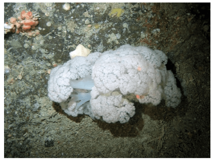
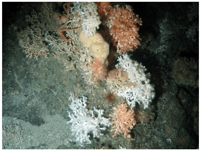
Figure 49. Feature images from East Rockall Bank SAC, showing a) soft coral (Nephtheidae) on rock with sponges (Porifera) and sea anemones (Anthozoa), and b) live cold water coral (Lophelia pertusa) with sponges and a crab (Brachyura) on rock ©NOC.
The area of the SAC is 3,695 km2 with reef habitat distributed throughout in the proportions in the Table 31 below.
Reef type |
Total area of habitat within SAC (km2) |
|---|---|
Bedrock |
313 |
Biogenic |
3 |
Stony |
314 |
Total |
630 |
19.3 Site Boundary
The boundary for the East Rockall Bank SAC was defined using the JNCC marine SAC boundary definition guidelines (JNCC, 2012a). The Annex I reef habitats are located at depths between 400 m and 600 m on the western side of the site, and between 1000 m and 1200 m on the eastern side. A buffer of 2 times water depth was applied ranging from 800 m at the shallowest part, to 2400 m at the deepest part.
19.4 Conservation objectives
JNCC’s view on the overall condition of the site’s qualifying feature is that it is in unfavourable condition and therefore needs to be restored to favourable condition.
The Conservation Objectives for the East Rockall Bank SAC are for the feature to be in favourable condition thus ensuring site integrity in the long term and contribution to Favourable Conservation Status of Annex I Reefs.
This contribution would be achieved by maintaining or restoring, subject to natural change: • The extent and distribution of the qualifying habitat in the site; • The structure and function of the qualifying habitat in the site; and • The supporting processes on which the qualifying habitat relies.
The full conservation advice documents can be found on the JNCC website. This includes the formal conservation advice for the site, background information and the full conservation objectives.
19.5 Pressure from demersal mobile fishing gear
Whilst it is unlikely that demersal mobile gears can affect the long-term natural distribution of bedrock and stony reef features, there is evidence to indicate that their use can impact the structure and function of the habitat and the long term survival of its associated species.
The use of demersal mobile fishing gears is likely to cause damage or death of fragile, erect species, such as sponges and corals (Freese et al., 1999; Løkkeborg, 2005). Other species such as hydroids, anemones, bryozoans, tunicates and echinoderms may also be vulnerable (McConnaughey et al., 2000; Sewell & Hiscock, 2005). Where fragile, slow growing species occur, even low levels of fishing have the potential to change the structure and function of the habitats and may result in the loss of some characteristic species.
Demersal mobile gears reduce the long-term natural distribution of cold-water coral (biogenic reef) features, as well as impacting the structure and function of the habitat and the long term survival of its associated species. The passage of mobile fishing gear may increase mortality of the coral by crushing, burying or wounding corals, increasing susceptibility to infection and epifaunal recruitment that may eventually smother corals (Fosså et al., 2002).
The passing of a heavy trawl reduces the three-dimensional structure of the coral to rubble, decreasing the complexity of the habitat with impacts on the associated community composition (Koslow et al., 2001; Fosså et al., 2002). Indirect impacts on cold water coral reefs from trawling are from increased levels of suspended particles in the water column causing smothering and polyp mortality (Larsson & Purser, 2011). Given the slow growth rate of the reefs, they may take centuries to recover from damage, if at all (ICES, 2010).
19.6 Pressure from demersal static fishing gear
Mechanical impacts of demersal static gear (e.g. weights and anchors hitting the seabed, hauling gear over seabed, rubbing/entangling effects of ropes) can damage some species (Eno et al.,1996). Other species appear to be resilient to individual fishing operations, but the effects of high fishing intensity are unknown (Eno et al., 2001). Recovery will be slow (Foden et al., 2010) resulting in significant reduction or even loss of characteristic species. The individual impact of a single fishing operation may be slight but cumulative damage may be significant (Eno et al., 2001; Foden et al., 2010).
Demersal static gears are likely to reduce the long-term natural distribution of cold-water coral (biogenic reef) features, as well as impacting the structure and function of the habitat and the long term survival of its associated species. The impacts are considered to be lower than for demersal mobile gear types (Pham et al., 2014), however impacts to habitats and biota may occur during certain conditions. For example, hooks, lines, nets and ropes entangle corals and may pluck them during hauling (Grehan et al., 2004; ICES, 2010, Sampaio et al., 2012). Physical damage to the seabed has been observed which may be caused by dragged anchors (Grehan et al., 2004; ICES, 2010). The individual impact of a single fishing operation may be slight but cumulative damage can be significant. Given the slow growth rate of the reefs, they may take centuries to recover from damage, if at all (ICES, 2010).
19.7 Levels of fisheries management considered
Table 32 provides a summary of the management advice set out against the various options that have been considered.
(Table 32) Summary of fisheries management advice for East Rockall Bank SAC
Fisheries management options considered for demersal mobile gear
No additional management: The conservation objectives for the biogenic reef feature would not be met under this level of management. There is a significant risk of not achieving the conservation objectives for the bedrock and stony reef features.
Reduce / limit pressures: This level of management would reduce the risk of not achieving the conservation objectives for the reef features. Appropriate management could include exclusion of demersal mobile gears over the main areas of bedrock and stony reef and all known areas of biogenic reef, allowing fishing to continue in fishable areas between the features. It is possible that some very small areas of unknown bedrock, stony and biogenic reef exist and there would therefore be a risk of localised damage to the structure and function of reef communities in these areas. The location of areas to be covered by management restrictions would include a buffer zone to reduce any risk of accidental contact with the feature.
Remove / avoid pressures: This level of management would reduce the risk not achieving the conservation objectives for the reef feature within the site boundary to the lowest possible levels.
Fisheries management options considered for demersal static gear
No additional management: The conservation objectives would not be met for biogenic reef. There is a risk of not achieving the conservation objectives for the bedrock and stony reef features.
Reduce / limit pressures: This level of management would reduce the risk of not achieving the conservation objectives for the reef feature. Appropriate management could include closure of the known extent of the biogenic reef feature within the site. The location of areas to be covered by management restrictions would include a buffer zone to reduce any risk of accidental contact with the feature.
Remove / avoid pressures: This level of management would reduce the risk of not achieving the conservation objectives for the reef feature within the site boundary to the lowest possible levels.
19.8 Other fisheries measures which apply to the site
Regulation (EU) 2019/1241 prohibits the deployment of any bottom-set gillnets, trammel nets and entangling nets where the chartered water depth is deeper than 600m to protect fish stocks, this applies to a substantial portion of this site making a contribution to furthering the conservation objectives of the site.
It should be noted that the part of this proposal to prohibit trawling in waters greater than 800 m depth has been encompassed in the new EU-wide Deep Sea Fisheries Regulation (EU) 2016/2336). This came into force in January 2017 and was transposed into UK legislation via The Common Fisheries Policy and Aquaculture (Amendment etc.) (EU Exit) Statutory Instrument (S.I.) 2019 No. 753. The Deep Sea Fisheries Regulation (now retained via Regulation (EU) 2019/1241) also includes provisions to protect areas containing Vulnerable Marine Ecosystems in waters greater than 400 m depth.
19.9 Proposed fisheries management and rationale
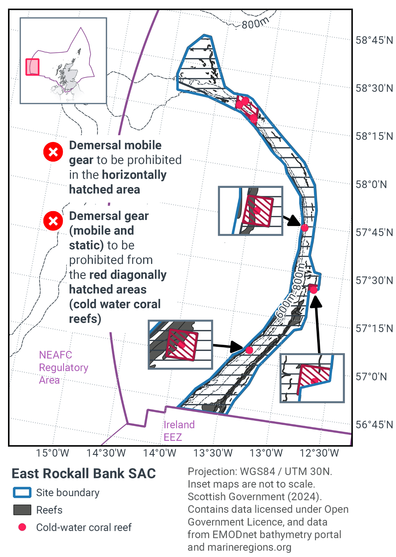
Table 33 and Figure 50 provide details of the proposed management approach and further explanation is provided below. Figure 51 shows the proposed fisheries management for full site prohibitions.
Protected feature |
Gear type |
Proposed management |
Measures |
|---|---|---|---|
Stony and bedrock reef |
Demersal mobile gear |
Reduce / limit pressure |
Prohibit all demersal mobile gear from 93.7% of the reef habitat. |
Demersal static gear |
No additional management |
No management for demersal static gear over stony and bedrock reef |
|
Biogenic reef |
Demersal mobile gear |
Remove / avoid pressures |
Prohibition of demersal mobile gear in all areas of known/predicted biogenic reef. |
Demersal static gear |
Remove / avoid pressures |
Prohibition of demersal static gear in all areas of known/predicted biogenic reef. |
Of the area of bedrock and stony reef, 6.3% would remain open to demersal mobile gears. Demersal static gears are prohibited in areas of known or predicted biogenic reef. Some areas the management boundary have been drawn closer to the reef feature than the SAC boundary. At the stakeholder workshop it was evident that vessels tow their gear parallel to the reef and therefore it has been decided that gear width may be used as the determining metric rather than water depth / warp length. This is a policy decision and whilst there is an increased risk of exposure it is not considered to be significant in this case.
The amount of reef that will be exposed to continued fishing pressure is very low when compared to the scale of the habitat within this SAC.
The measures will contribute to achieving favourable conservation status of Annex I reefs in the Atlantic Marine Biogeographic region. They will also contribute to VME protection and the recovery of the OSPAR listed Threatened and/or Declining habitats deep-sea sponge aggregations, coral gardens, and Lophelia pertusa.
Table 34 and Table 35 detail the proportion of each Annex I reef subtype that would be protected from demersal mobile gear and demersal static gear respectively.
Reef type |
Total area of habitat within SAC (km2) |
Area within demersal mobile management zone (km2) |
% reef habitat protected by demersal mobile management zone |
|---|---|---|---|
Bedrock |
313 |
274 |
87.6% |
Biogenic |
3 |
3 |
100% |
Stony |
314 |
313 |
99.7% |
Total |
630 |
590 |
93.7% |
Reef type |
Total area of habitat within SAC (km2) |
Area with demersal static management zone (km2) |
% reef habitat protected by demersal static management zone |
|---|---|---|---|
Bedrock |
313 |
0 |
0.00% |
Biogenic |
3 |
3 |
100.00% |
Stony |
314 |
0 |
0.00% |
Total |
630 |
3 |
0.4% |
Contact
Email: marine_biodiversity@gov.scot
There is a problem
Thanks for your feedback