Fisheries Management Measures within Scottish Offshore Marine Protected Areas (MPAs) - Site Proposal Document
This document describes the process, justification and evidence used to develop site specific management measures. It outlines key information for each site including their features, and risks of potential pressures.
20. Geikie Slide and Hebridean Slope MPA
20.1 Description and background
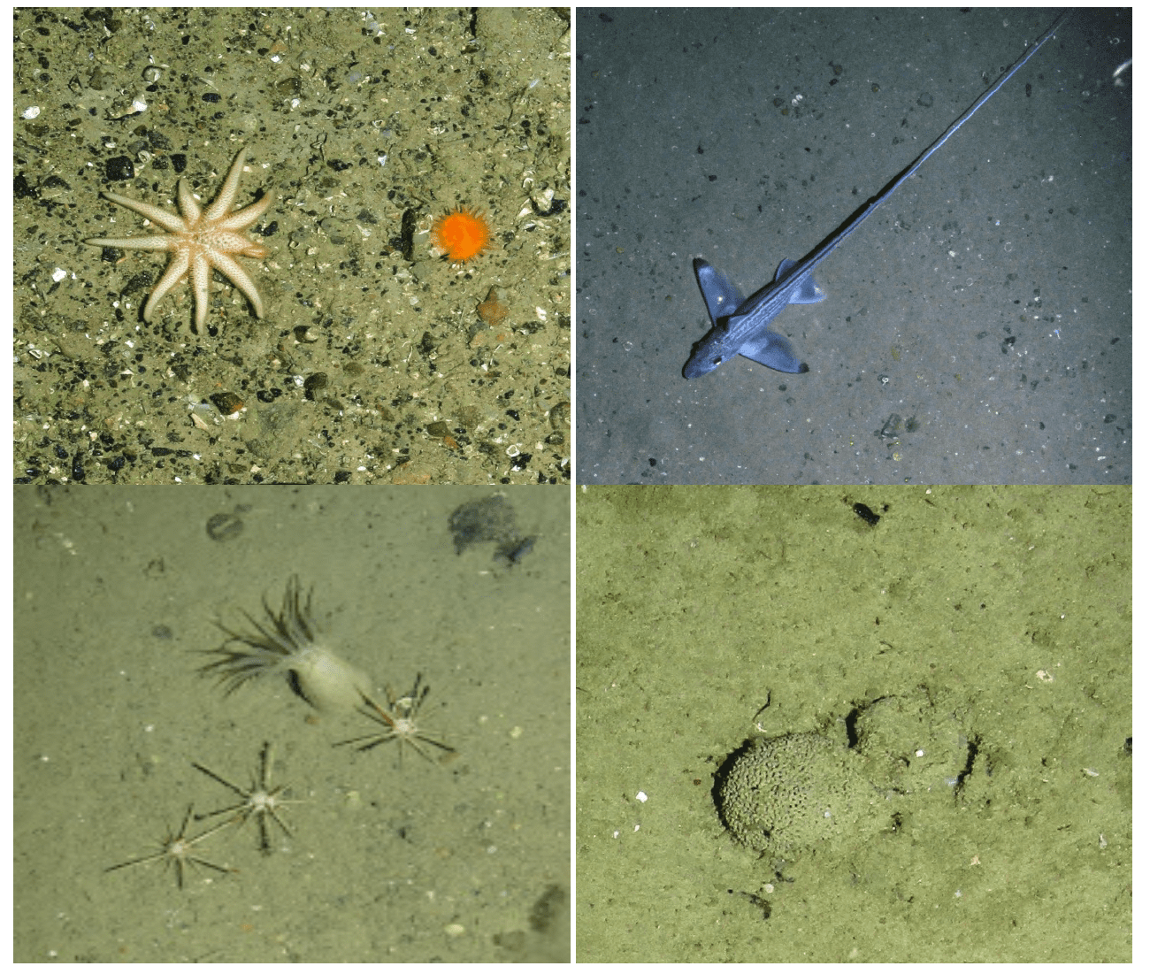
The Geikie Slide and Hebridean Slope MPA is located to the north-west of Scotland and follows the seabed from a depth of 200 m into the deep water (>1700 m) of the Rockall Trough, as shown in Figure 52 Habitats within the MPA vary down the slope with a range of Atlantic-influenced sediments. These include deep sea mud and offshore subtidal sand and gravel, including a deep-water variant of the seapens and burrowing megafauna biotope (Figure 53).
The site also includes the geomorphological slide deposit feature representative of The Geikie Slide Key Geodiversity Area (Brooks et al., 2013) as well as a section of the large scale feature the Hebridean continental slope. The MPA covers an area of 2,215 km2 and the protected habitat features are present across most of the site.
Further information can be found in the Site Information Centre.
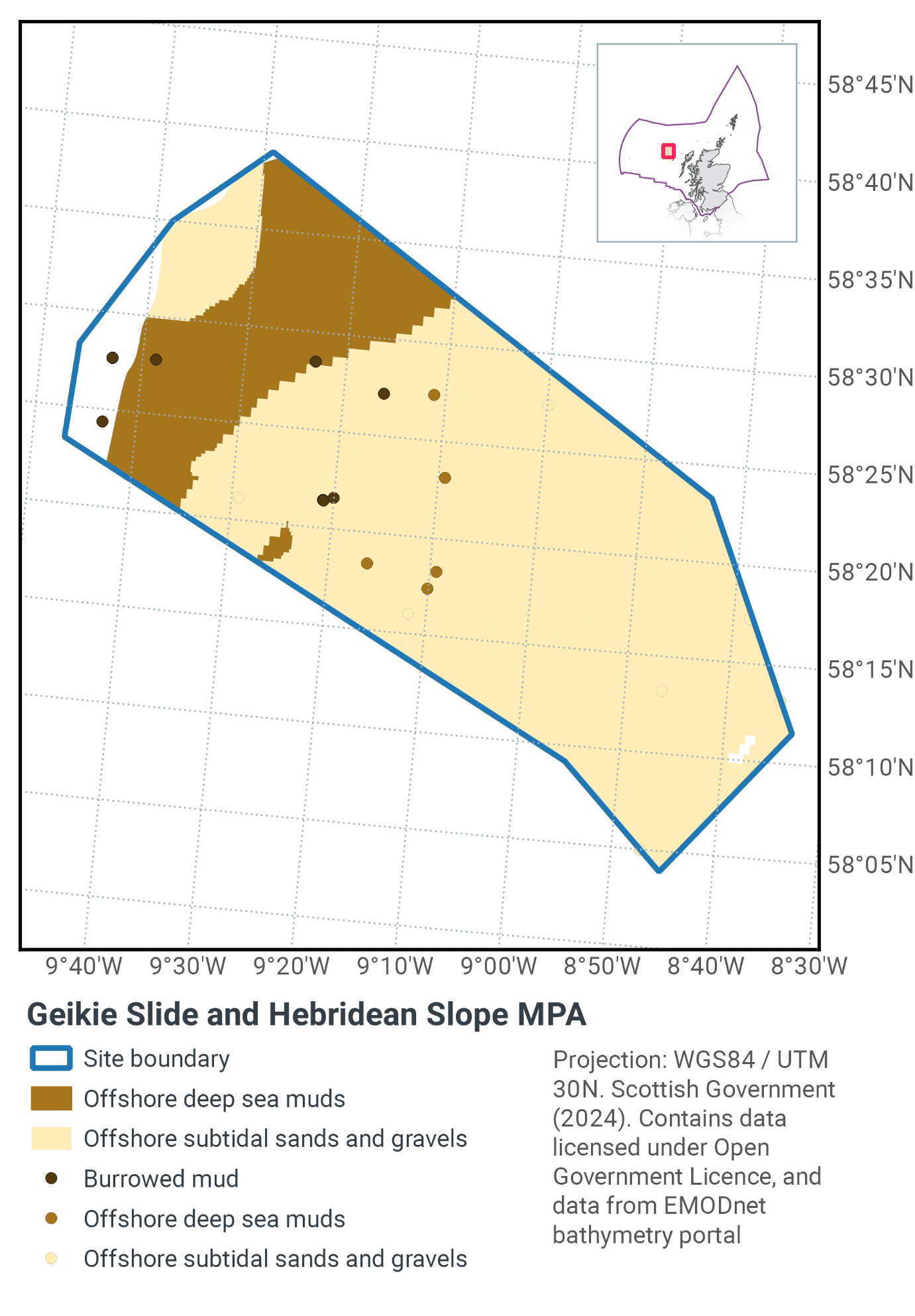
20.2 Site Features
The Geikie Slide and Hebridean Slope MPA is designated for the following protected features:
- Burrowed mud (seapens and burrowing megafauna),
- Offshore subtidal sands and gravels
- Offshore deep-sea muds
- Continental slope
- Slide deposits and slide scars representative of the Geikie Slide Key Geodiversity Area
The MPA encompasses all records of burrows from Scottish Government deep-water towed video surveys. It also includes evidence of seapen by-catch recorded from Scottish Government trawl surveys which is indicative of the OSPAR threatened and/or declining habitat “Sea-pen and Burrowing Megafauna Communities”. The MPA boundary creates a corridor down the slope that includes examples of the different biological zones that characterise the Hebridean slope.
More information regarding the site selection process for the Geikie Slide and Hebridean Slope MPA is available in the detailed assessment against the Scottish MPA Selection guidelines.
20.3 Site Boundary
The boundary was set in accordance with the boundary setting principles outlined in the MPA Selection Guidelines. It focuses on the area of greatest feature data record holdings and was designed to represent all depth strata of the continental slope. This was to provide the best opportunity for representation of the full range of associated biological communities which are reported to vary with depth (Hughes et al., 2014). The boundary also incorporates a submarine landslide feature called the Geikie Slide from which the site takes its name.
Confidence in the presence and extent of the protected features has been set out in the Data Confidence Assessment.
20.4 Conservation objectives
JNCC’s view on the overall condition of the site’s qualifying features Burrowed mud, offshore subtidal sands and gravels and offshore deep-sea muds is that they are in unfavourable condition and therefore need to be restored to favourable condition.
Continental shelf and Slide deposits and slide scars representative of the Geikie Slide Key Geodiversity Area are considered to be in favourable condition and therefore need to be maintained in favourable condition.
The Conservation Objective for the Geikie Slide and Hebridean Slope MPA is that the protected features listed below - • so far as already in favourable condition, remain in such condition; and • so far as not already in favourable condition, be brought into such condition, and remain in such condition
The full conservation advice documents can be found on the JNCC website. This includes the formal conservation advice for the site, background information and the full conservation objectives.
20.5 Pressure from demersal mobile fishing gear
Studies have shown that areas of mud habitats (which include burrowed mud and offshore deep-sea mud) subject to demersal mobile fishing activity support a modified biological community with lower diversity, reduction or loss of long-lived filter-feeding species and increased abundance of opportunistic scavengers (Ball et al., 2000; Tuck et al., 1998). This effect was greatest in the more heavily fished offshore areas suggesting that impact is related to the intensity of fishing (Ball et al., 2000). Furthermore, modelling studies suggest that the greatest impact is produced by the first pass of a trawl (Hiddink et al., 2006).
Where sand and gravel sediments occur in high energy locations (i.e. of wave and/or tide exposed) the associated fauna tend to be well adapted to disturbance and as a result are more tolerant of fishing-related disturbance (Dernie et al., 2003; Hiddink et al., 2006). However, in lower energy deep water locations such as the Geikie Slide and the Hebridean Slope MPA, sediments tend to be more stable and their associated fauna less tolerant of disturbance (Hiddink et al., 2006; Kaiser et al., 2006). Stable gravels often support a ‘turf’ of fragile species which are easily damaged by trawling and recover slowly (Collie et al., 2005; Foden et al., 2010).
Trawling and dredging tends to cause increased mortality of fragile and long-lived species and favour opportunistic, disturbance-tolerant species (Eleftheriou & Robertson, 1992; Bergman & van Santbrink, 2000). Some particularly sensitive species may disappear entirely (Bergman & van Santbrink, 2000). The net result is benthic communities modified to varying degrees relative to the un-impacted state (Bergman & van Santbrink, 2000; Kaiser et al., 2006).
20.6 Pressure from demersal static fishing gear
Features in the Geikie Slide and Hebridean Slope MPA are not considered to be sensitive to static gears.
20.7 Levels of fisheries management considered
Table 36 provides a summary of the management advice set out against the various options that have been considered.
(Table 36) Summary of fisheries management advice for Geikie Slide and Hebridean Slope MPA
Fisheries management options considered for demersal mobile gear
No additional management: There is a risk of not achieving the conservation objectives for burrowed mud, offshore deep sea mud, and offshore subtidal sands and gravels.
Reduce / limit pressures: This level of management would reduce, but not entirely eliminate, the risk of not achieving the conservation objectives for burrowed mud, offshore deep sea mud, and offshore subtidal sands and gravels. Appropriate management could include restrictions on fishing with damaging gears over a proportion of each feature’s extent, and there may be a greater requirement for restrictions on gears that penetrate deeply into the sediment.
Remove / avoid pressures: This level of management would reduce the risk of not achieving the conservation objectives for burrowed mud, offshore deep sea mud, and offshore subtidal sands and gravels to the lowest possible levels.
Fisheries management options considered for demersal static gear
No additional management: JNCC consider this level of management to be sufficient for demersal static gears to achieve the conservation objectives for burrowed mud, offshore deep sea muds, and offshore subtidal sands and gravels.
20.8 Other fisheries measures which apply to the site
Regulation (EU) 2019/1241 prohibits the deployment of any bottom-set gillnets, trammel nets and entangling nets where the chartered water depth is deeper than 600m to protect fish stocks, this applies to a substantial portion of this site making a contribution to furthering the conservation objectives of the site.
It should be noted that the part of this proposal to prohibit trawling in waters greater than 800 m depth has been encompassed in the new EU-wide Deep Sea Fisheries Regulation (EU) 2016/2336). This came into force in January 2017 and was transposed into UK legislation via The Common Fisheries Policy and Aquaculture (Amendment etc.) (EU Exit) Statutory Instrument (S.I.) 2019 No. 753.
20.9 Proposed fisheries management and rationale
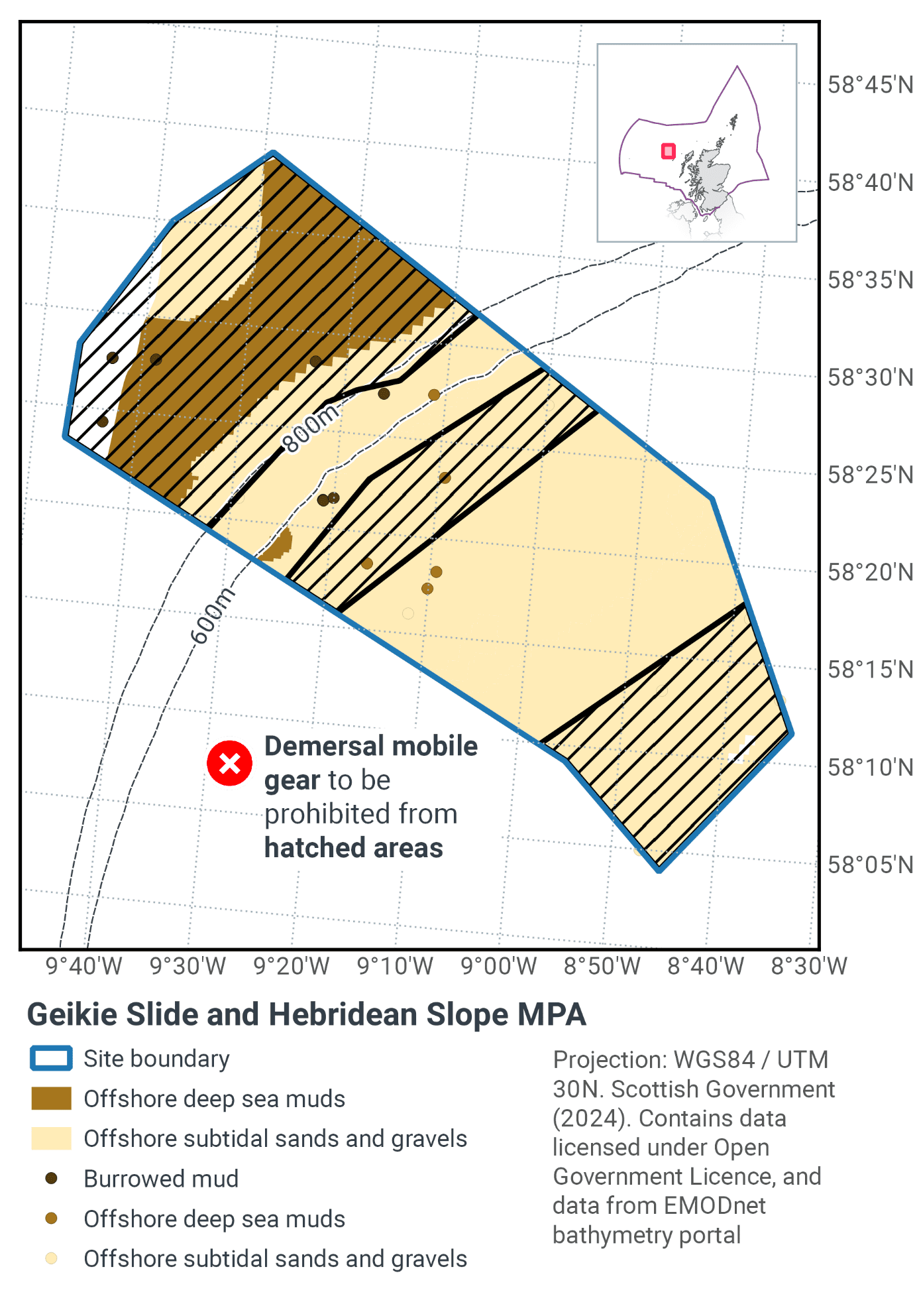
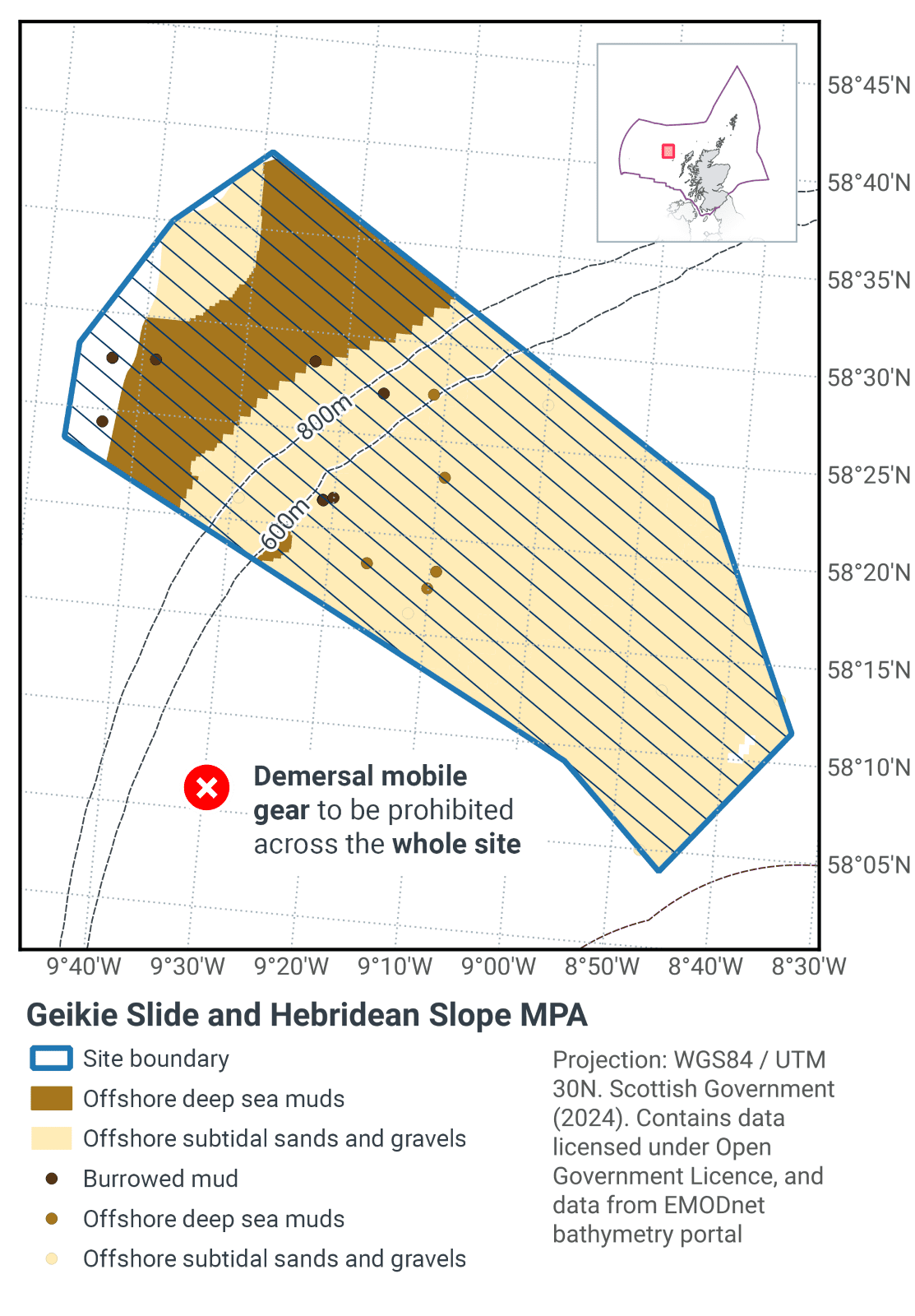
Table 37 and Figure 54 provide details of the proposed management approach and further explanation is provided below. Figure 55 shows the proposed fisheries management for full site prohibitions.
The continental slope and slide deposit geodiversity feature are considered to have a low sensitivity to the pressures associated with marine activities taking place within the MPA. As such, JNCC do not consider there is a significant risk to the features achieving their conservation objectives and so the features have not been considered further in the context of the management options presented below. Further information is available within the JNCC MPA Management Options Paper.
Protected feature |
Gear type |
Proposed management |
Measures |
|---|---|---|---|
Burrowed mud (seapens and burrowing megafauna), offshore subtidal sands and gravels, offshore deep-sea muds |
Demersal mobile gear |
Reduce / limit pressure |
Zonal restriction to remove pressure from a proportion of each habitat across various depth ranges. No demersal mobile gear fishing deeper than 800m. |
Demersal static gear |
No additional management |
No additional management required for demersal static gear |
Management measures will be applied to the upper, middle, and lower parts of the slope. This approach is designed to ensure that a proportion of each protected feature is represented across different depth zones. This means that a range of the biological communities present from the upper shelf to the base of the slope will be covered within the management zones.
The measures will help further the recovery of the OSPAR threatened and/or declining habitat sea-pen and burrowing megafauna communities. They should also further progress towards Good Environmental Status in the Celtic Seas, particularly in relation to Descriptors 1 (biological diversity) and 6 (sea-floor integrity).
The remainder of the site will effectively remain as fishing corridors to enable trawling to continue through the MPA on a somewhat restricted basis.
The lower management boundary for demersal mobile gears has been drawn on the 800 m contour. In waters deeper than 800 m the collateral damage to vulnerable species exceeds the commercial return from trawl fisheries (Clarke et al., 2015). Therefore, continued trawl activity below that depth would not be considered a sustainable use of the MPA. In addition, proposing a restriction to all demersal mobile-gear would aid compliance and enforcement of the northern portion of the site, where this site boundary overlaps with the West of Scotland MPA, and provides consistency of management measures across overlapping sites.
Contact
Email: marine_biodiversity@gov.scot
There is a problem
Thanks for your feedback