Fisheries Management Measures within Scottish Offshore Marine Protected Areas (MPAs) - Site Proposal Document
This document describes the process, justification and evidence used to develop site specific management measures. It outlines key information for each site including their features, and risks of potential pressures.
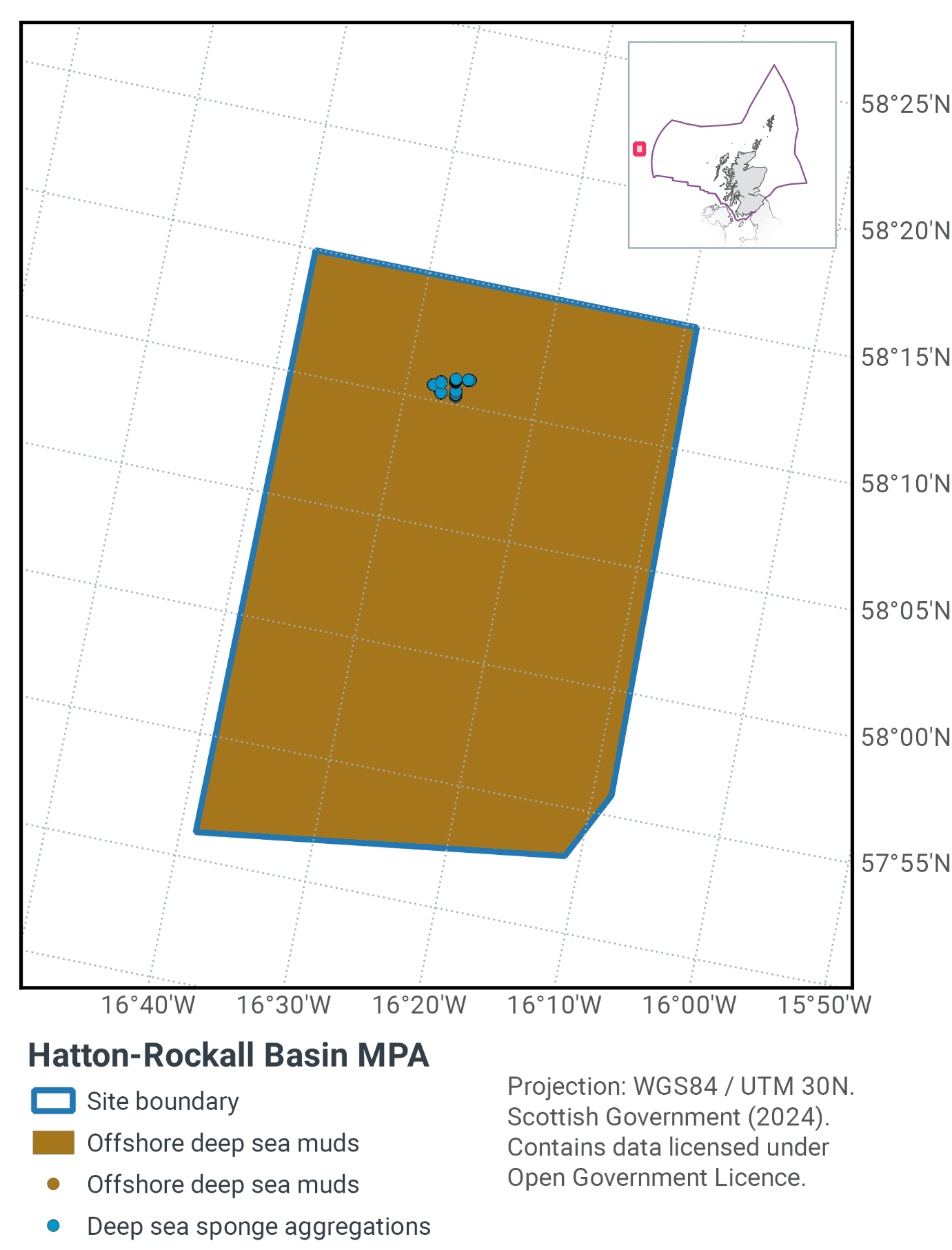
22. Hatton Rockall Basin MPA
22.1 Description and background
The Hatton-Rockall Basin MPA is situated in a deep-water basin to the far west of Scotland (Figure 58). Water depth at the site is over 1 km and the muddy sediments present support a range of species adapted to life at this depth.
Different types of animals can be found living in, and on, the muddy seabed within the MPA. Echinoderms, are some of the most common animals found here, including sea cucumbers, starfish and sea urchins. The MPA also includes aggregations of deep-sea sponges, such as the birds-nest sponge. Associated with the harder edges of the polygonal faults, the sponge aggregations are hotspots of biodiversity, supporting many other species. The spine-like ‘spicule’ remnants left behind by dead sponges cover the seabed, preventing burrowing animals from establishing. This barrier enables animals that live on the seabed surface to thrive, including mats of brittlestars that wave their arms in the passing currents in pursuit of food.
Further information can be found in the site information centre.
22.2 Site features
The Hatton Rockall Basin MPA is designated for the following protected features:
- Deep-sea sponge aggregations
- Offshore deep sea muds
- Sediment drifts and polygonal faults representative of Hatton Bank (and adjacent sea floor) Key Geodiversity Area.
22.3 Site Boundary
The site is a simple polygon drawn to include all verified records of deep-sea sponges within the entire Hatton-Rockall Basin. The boundary has also been drawn to incorporate significant areas of both types of offshore deep-sea muds present in the region.
22.4 Conservation Objectives
JNCC’s view on the overall condition of the site’s qualifying features is uncertain.
The Conservation Objective for the Hatton-Rockall Basin Nature Conservation Marine Protected Area is that the protected features:
- so far as already in favourable condition, remain in such condition; and
- so far as not already in favourable condition, be brought into such condition, and remain in such condition.
The full conservation advice documents can be found on the JNCC website. This includes the formal conservation advice for the site, background information and the full conservation objectives.
22.5 Pressure from demersal mobile fishing gear
Studies have shown that areas of mud habitats (which include burrowed mud and offshore deep-sea mud) subject to demersal mobile fishing activity support a modified biological community with lower diversity, reduction or loss of long-lived filter-feeding species and increased abundance of opportunistic scavengers (Ball et al., 2000; Tuck et al., 1998). This effect was greatest in the more heavily fished offshore areas suggesting that impact is related to the intensity of fishing (Ball et al., 2000). Furthermore, modelling studies suggest that the greatest impact is produced by the first pass of a trawl (Hiddink et al., 2006).
As with demersal trawls and dredges, demersal seines may impact the structure and function of sedimentary habitats and the long-term survival of their associated species. There are currently no direct studies on the physical impacts of demersal seines. Modelling studies suggest that demersal seines have a large overall footprint (i.e. the surface area covered during one hour fishing) (Eigaard et al. 2016). Hiddink et al. (2017) suggest that depletion of biota is highly correlated with seabed penetration depth by trawls. Seines lack the heavy gear components (e.g. otter doors, trawl shoes) of other demersal mobile gears (Suuronen et al. 2012; Donaldson et al. 2010) and therefore, despite the relatively large footprint, impacts associated with penetration into the sediment are likely to be lower. Eigaard et al. (2016) modelled surface (<2cm) and subsurface (>2cm) impacts and found that demersal seines have some of the smallest proportions of subsurface impact.
The use of demersal mobile fishing gears is likely to cause damage or death of fragile, erect species, such as sponges and corals (Freese et al., 1999; Løkkeborg, 2005). Other species such as hydroids, anemones, bryozoans, tunicates and echinoderms may also be vulnerable (McConnaughey et al., 2000; Sewell & Hiscock, 2005). Where fragile, slow growing species occur, even low levels of fishing have the potential to change the structure and function of the habitats and may result in the loss of some characteristic species.
22.6 Pressure from demersal static fishing gear
Mechanical impacts of demersal static gear (e.g. weights and anchors hitting the seabed, hauling gear over seabed, rubbing/entangling effects of ropes) can damage some species (Eno et al.,1996). Other species appear to be resilient to individual fishing operations, but the effects of high fishing intensity are unknown (Eno et al., 2001). Recovery will be slow (Foden et al., 2010) resulting in significant reduction or even loss of characteristic species.
Although the individual impact of a single fishing operation may be slight, cumulative damage may be significant (Eno et al., 2001; Foden et al., 2010), however sensitivity to low intensity potting is considered low (Hall et al., 2008). Overall, the protected feature within the site is not considered to be sensitive to demersal static gear activity.
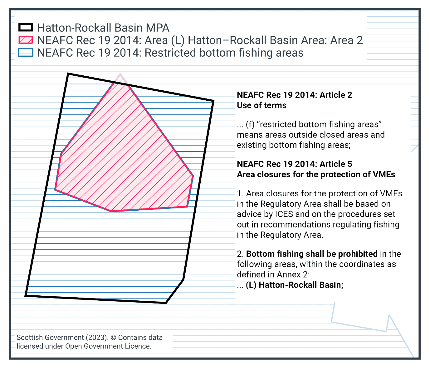
22.7 Other fisheries measures which apply to the site
Hatton-Rockall Basin NCMPA is situated in a "new bottom fishing area" under current NEAFC regulations. Any proposed new fishing activity would require an environmental assessment to show damage would not be caused to Vulnerable Marine Ecosystems (VMEs), which in this case constitutes one of the protected features of the site: Deep-sea sponge aggregations.
An area in the north of Hatton-Rockall Basin NCMPA is also closed to bottom fisheries under NEAFC Recommendation 19 2014: Protection of VMEs in NEAFC Regulatory Areas, as Amended by Recommendation 09:2015 and Recommendation 10:2018 to protect Vulnerable Marine Ecosystems (VMEs), namely deep-sea sponge aggregations (Figure 59).
22.8 Proposed fisheries management and rationale
Considering the management already in place, the site is considered to be sufficiently managed for the site conservation objectives and no further management is proposed, as shown in Figure 59.
Contact
Email: marine_biodiversity@gov.scot
There is a problem
Thanks for your feedback