Fisheries Management Measures within Scottish Offshore Marine Protected Areas (MPAs) - Site Proposal Document
This document describes the process, justification and evidence used to develop site specific management measures. It outlines key information for each site including their features, and risks of potential pressures.
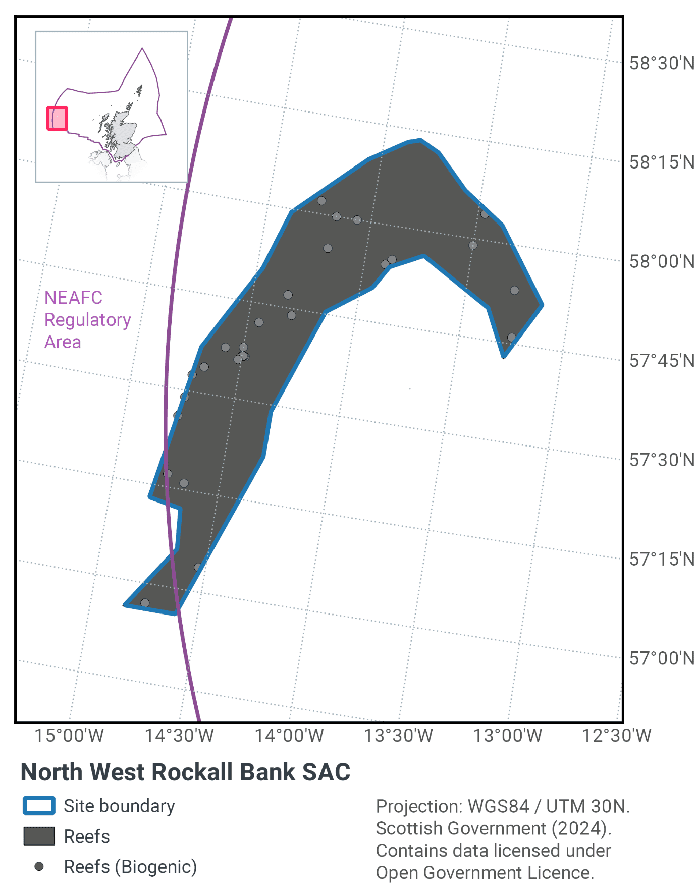
23. North West Rockall Bank SAC
23.1 Description and background
Rockall Bank is an offshore bank situated in the North-East Atlantic, approximately 400 km west of the Outer Hebrides, as shown in Figure 60. It is oriented northeast to southwest, and is approximately 450 km in length and 200 km wide. Depth ranges from over 1,000 m at the base of the Rockall Bank, to 200 m across much of the top. The centre of the bank breaks the surface forming a rocky island outcrop around 25 m wide and 20 m high. On account of their sheer size, oceanic banks such as Rockall cause the deviation of ocean currents along their flanks. This facilitates the colonization of habitat-forming corals which depend on a consistent supply of current-transported organic matter and zooplankton (Freiwald et al., 2004). Rockall Bank is potentially one of the most extensive sites for biogenic reef formed by cold water coral species in UK waters.
The northwest area of the Rockall Bank is covered in a layer of fine sediment, gravel, cobbles and boulders of glacial origin, some of which was shaped into characteristic ‘plough mark’ formations by icebergs during the last ice age. These iceberg plough marks are a variant of Annex I stony reef and consist of lines of cobbles and boulders with a sediment-filled furrow between. The wide variety of associated biological communities are dependent on this mixed sediment and stony substratum, rather than on the underlying bedrock. Included within areas of stony reef are sizeable patches of Annex I biogenic reef comprising the cold-water coral Lophelia pertusa and associated species, including erect sponges and the pencil urchin Cidaris cidaris. Stands of Madrepora oculata, another cold water coral species, are also present.
Further information can be found in the Site Information Centre.
23.2 Site Features
The North West Rockall Bank SAC is designated for the following protected features:
- Stony and biogenic reef (Annex I Reefs).
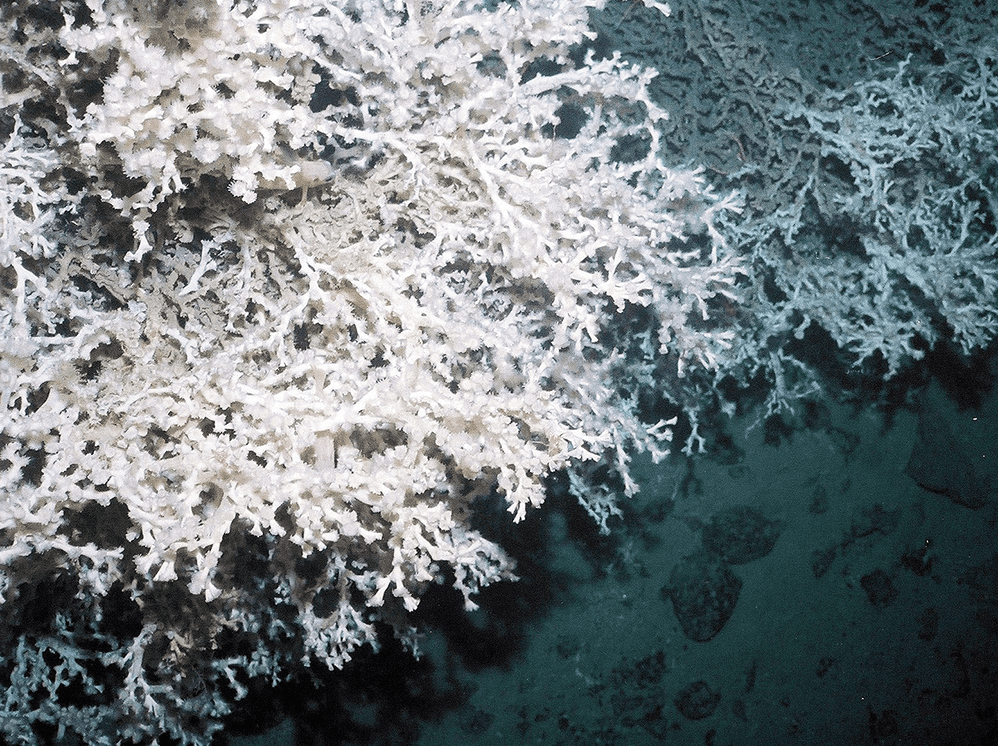
This site was designated because it contains sizeable patches of Annex I Lophelia pertusa reef (Figure 61) and associated species and therefore makes a valuable contribution to the UK Network. Additionally, iceberg ploughmarks within the site form a variant of Annex I stony reef and consist of lines of cobbles and boulders with a sediment-filled furrow between (Howell et al 2009). Coral rubble surrounds the living reefs in many places and supports fauna such as the squat lobster Munida rugosa, the holothurian Parastichopus tremulus, the pencil urchin Cidaris cidaris, brittle stars and encrusting yellow sponges. Strands of Madrepora oculata, another cold-water coral species, are also present (Howell et al., 2009). Evidence from the 1970s suggests that areas of Lophelia pertusa reef up to 30 m in diameter existed on the Northwest Rockall Bank SAC (Wilson, 1979a and 1979b; Davies and Roberts, 2006), though more recent surveys (albeit at different locations in this region) have recorded reefs smaller in size (Howell et al., 2009).
The area of the SAC is 4,365 km2 with reef habitat distributed throughout the site. Although point records in the form of survey ground truth data confirm the presence of Annex I stony and biogenic reef subtypes, high resolution data is not available across the site to allow for reef extents to be mapped at a fine scale. Given the records available, and what is known about the location and conditions associated with the site, it is likely that Annex I reef is distributed across the SAC, although there may be areas where it is patchy in distribution. Therefore, the estimated extent of reef habitat within the SAC is the same as the area of the site; 4,365 km2.
23.3 Site Boundary
The site boundary for North West Rockall Bank SAC was defined using JNCC’s marine SAC boundary definition guidelines (JNCC, 2012a). On the western side of the site, coral records occur in approximately 300 m water depth, so a margin of twice water depth (600 m) was applied to these points. On the eastern side of the site adjacent to Rockall Rock, coral records occur in approximately 200 m water depth, so a margin of twice water depth (400 m) was applied to these points. The site boundary extends slightly into waters under the jurisdiction of the North East Atlantic Fisheries Commission (NEAFC). It is notable that the site boundary follows, for the most part, the boundary of the EU/NEAFC demersal fishing closure (EC Regulation No 227/2013[1], NEAFC Recommendation 19:2014 as amended by Recommendation 09:2015 and 10:2018)[2].
23.4 Conservation objectives
JNCC’s view on the overall condition of the site’s qualifying feature is that it is in unfavourable condition and therefore needs to be restored to favourable condition.
The Conservation Objectives for the North West Rockall Bank SAC are for the feature to be in favourable condition thus ensuring site integrity in the long term and contribution to Favourable Conservation Status of Annex I Reefs.
The full conservation advice documents can be found on the JNCC website. This includes the formal conservation advice for the site, background information and the full conservation objectives.
23.5 Pressure from demersal mobile fishing gear
Whilst it is unlikely that demersal mobile gears can affect the long-term natural distribution of stony reef features, there is evidence to indicate that their use can impact the structure and function of the habitat and the long term survival of its associated species.
The use of demersal mobile fishing gears is likely to cause damage or death of fragile, erect species, such as sponges and corals (Freese et al., 1999; Løkkeborg, 2005). Other species such as hydroids, anemones, bryozoans, tunicates and echinoderms may also be vulnerable (McConnaughey et al., 2000; Sewell & Hiscock, 2005). Where fragile, slow growing species occur, even low levels of fishing have the potential to change the structure and function of the habitats and may result in the loss of some characteristic species.
Demersal mobile gears reduce the long-term natural distribution of cold-water coral (biogenic reef) features, as well as impacting the structure and function of the habitat and the long term survival of its associated species. The passage of demersal mobile fishing gear may increase mortality of the coral by crushing, burying or wounding corals, increasing susceptibility to infection and epifaunal recruitment that may eventually smother corals (Fosså et al., 2002).
The passing of a heavy trawl reduces the three-dimensional structure of the coral to rubble, decreasing the complexity of the habitat with impacts on the associated community composition (Koslow et al., 2001; Fosså et al., 2002). Indirect impacts on cold water coral reefs from trawling are from increased levels of suspended particles in the water column causing smothering and polyp mortality (Larsson & Purser, 2011). Given the slow growth rate of the reefs, they may take centuries to recover from damage, if at all (ICES, 2010).
23.6 Pressure from demersal static fishing gear
Mechanical impacts of demersal static gear (e.g. weights and anchors hitting the seabed, hauling gear over seabed, rubbing/entangling effects of ropes) can damage some species (Eno et al., 1996). Other species appear to be resilient to individual fishing operations but the effects of high fishing intensity are unknown (Eno et al., 2001).Recovery will be slow (Foden et al., 2010) resulting in significant reduction or even loss of characteristic species. The individual impact of a single fishing operation may be slight but cumulative damage may be significant (Eno et al., 2001; Foden et al., 2010).
Demersal static gears are likely to reduce the long-term natural distribution of cold water coral (biogenic reef) features, as well as impacting the structure and function of the habitat and the long term survival of its associated species.
The impacts are considered to be lower than for demersal mobile gear types (Pham et al. 2014), however impacts to habitats and biota may occur during certain conditions. For example, hooks, lines, nets and ropes entangle corals and ‘pluck’ them during hauling (Grehan et al., 2004; ICES, 2010; Sampaio et al. 2012). Physical damage to the seabed has been observed which may be caused by dragged anchors (Grehan et al., 2004; ICES, 2010). The individual impact of a single fishing operation may be slight but cumulative damage can be significant. Given the slow growth rate of the reefs, they may take centuries to recover from damage, if at all (ICES, 2010).
23.7 Levels of fisheries management considered
Table 38 provides a summary of the management advice set out against the various options that were considered.
(Table 38) Summary of fisheries management advice for North West Rockall Bank SAC
Fisheries management options considered for demersal mobile gear
No additional management: The conservation objectives for the biogenic reef feature would not be met under this level of management. There is a significant risk of not achieving the conservation objectives for the stony reef feature.
Reduce / limit pressures: This level of management would reduce the risk of not achieving the conservation objectives for the reef features. Management could include exclusion of demersal mobile gears over a proportion of the Annex I stony reef and all known areas of Annex I biogenic reef. The location of areas to be covered by management restrictions for Annex I biogenic reef could include a buffer zone to reduce any risk of accidental contact with the feature.
Remove / avoid pressures: This level of management would reduce the risk not achieving the conservation objectives for the Annex I reef feature within the site boundary to the lowest possible levels.
Fisheries management options considered for demersal static gears
No additional management: The conservation objectives would not be met for Annex I biogenic reef. There is a risk of not achieving the conservation objectives for the Annex I stony reef feature.
Reduce / limit pressures: This level of management would reduce the risk of not achieving the conservation objectives for the Annex I reef feature. Appropriate management could include closure of the known extent of the Annex I biogenic reef feature within the site. The location of areas to be covered by management restrictions for Annex I biogenic reef could include a buffer zone to reduce any risk of accidental contact with the feature.
Remove / avoid pressures: This level of management would reduce the risk of not achieving the conservation objectives for the Annex I reef feature within the site boundary to the lowest possible levels.
23.8 Other fisheries measures which apply to the site
The area of the site within Scottish waters that remains open to fishing, is protected
The North West Rockall Bank SAC boundary follows, for the most part, the boundary of the NEAFC/EC demersal fishing (NEAFC Recommendation 19:2014 as amended by Recommendation 09:2015 and 10:2018)[3]. However, there remain small areas of the SAC within the UK Exclusive Economic Zone (EEZ) which are not currently covered by the existing fisheries closure. Demersal fishing continues in areas of the SAC that lie outside of the current fisheries closure: these areas contain species that are typical of stony and biogenic reef and are highly sensitive to damage from demersal trawling. Evidence from surveys suggests there has been damage to a “coral mound” feature formed by Lophelia pertusa, located in an area of the site not covered by the NEAFC/EC closure. Further details relating to the existing closure, and evidence relating to the coral damage can be found in ANNEX 1.
23.9 Proposed fisheries management and rationale
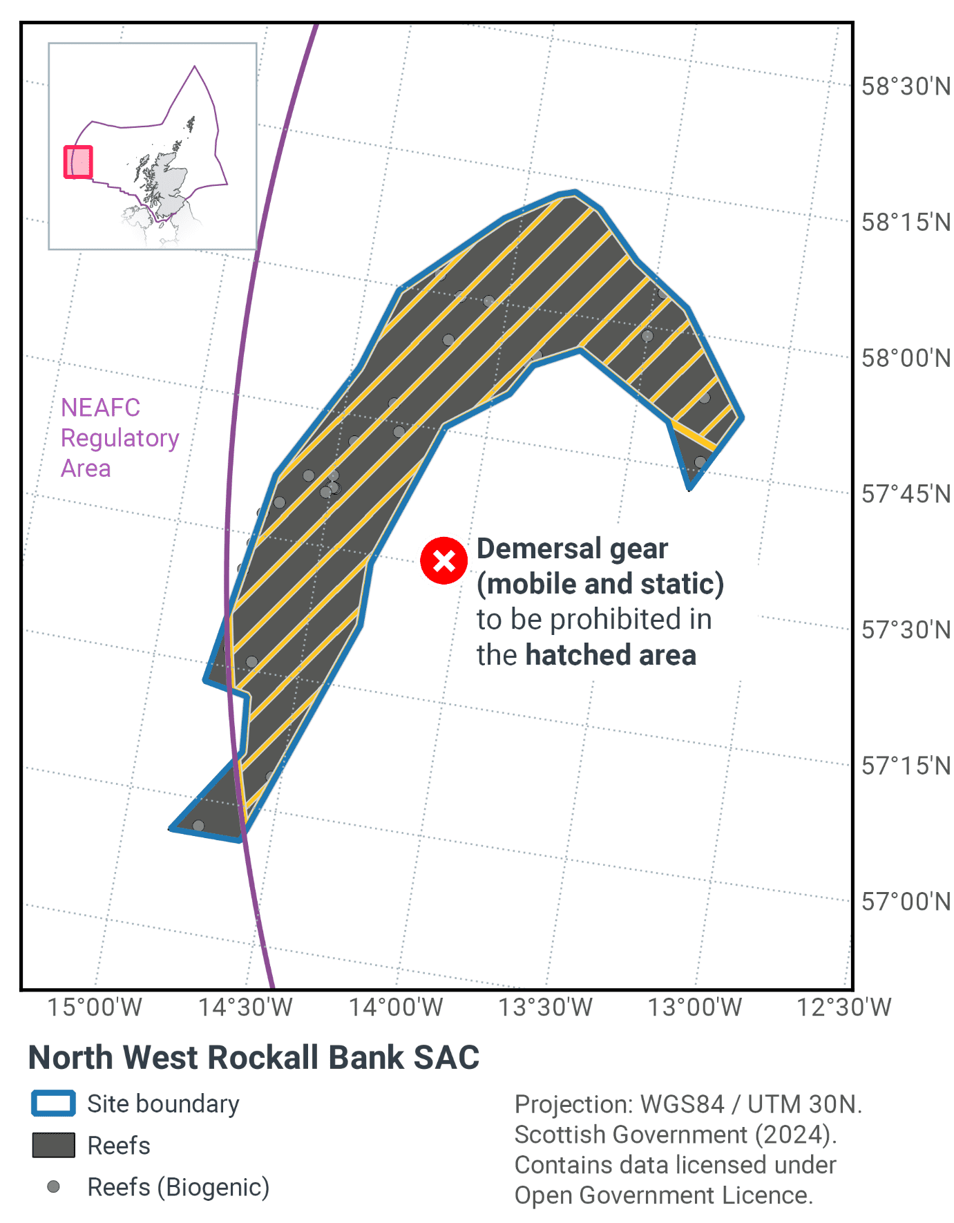
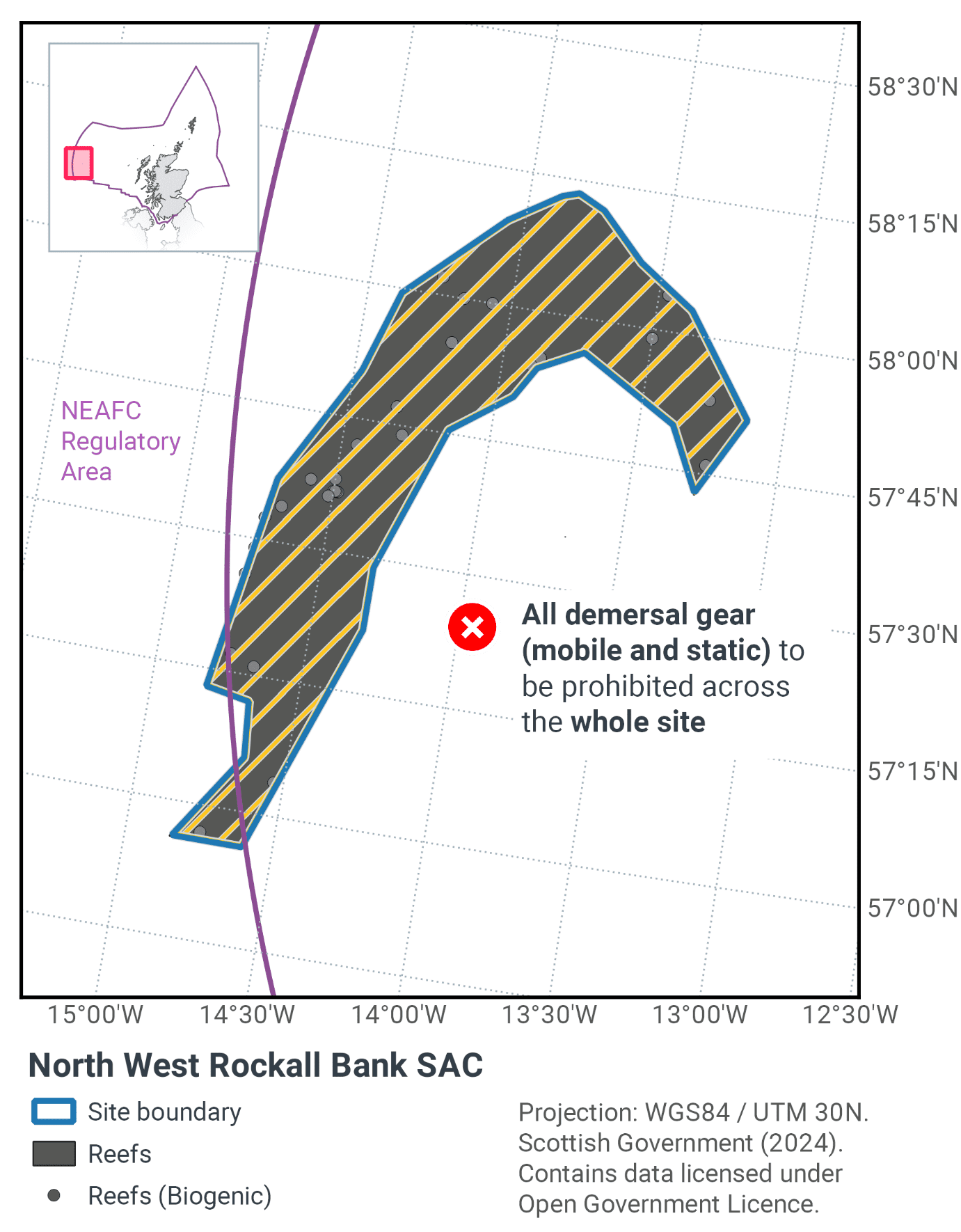
Table 39 and Figure 62 provides details of the proposed management approach and further explanation is provided. Figure 63 shows the proposed fisheries management for full site prohibitions.
Protected feature |
Gear type |
Proposed management |
Measures |
|---|---|---|---|
Stony and biogenic reef |
Demersal mobile gears |
Reduce / limit pressures |
Capture measures currently implemented under a NEAFC/EC demersal mobile and demersal static fishing closure. |
Demersal static gears |
Reduce / limit pressures |
The presence of Annex I biogenic reef within the site means that the measures need to manage both demersal mobile and demersal static fishing gears. These measures will help improve the conservation status of Annex I reef in the Atlantic marine biogeographic region. In addition, the measures will contribute to the recovery of cold-water coral reef and Lophelia pertusa. Both of these are listed by OSPAR as Threatened and/or Declining habitats in OSPAR region V and VMEs. They should also further progress towards Good Environmental Status, particularly in relation to Descriptors 1 (biological diversity) and 6 (sea-floor integrity).
The measures proposed will cover portions of the North West Rockall Bank SAC that are not currently subject to measures under the existing NEAFC/EC demersal fishing closure.
Under the proposed measures developed with industry, 98.24% of the Annex I reef (including stony and biogenic reef subtypes) would be protected from demersal mobile and demersal static fishing gears. It is not possible to provide figures for coverage of each reef subtype as high-resolution data is not available across the site to allow for reef extents to be mapped at a fine scale.
Contact
Email: marine_biodiversity@gov.scot
There is a problem
Thanks for your feedback