Fisheries Management Measures within Scottish Offshore Marine Protected Areas (MPAs) - Site Proposal Document
This document describes the process, justification and evidence used to develop site specific management measures. It outlines key information for each site including their features, and risks of potential pressures.
24. Solan Bank Reef SAC
24.1 Description and background
Solan Bank Reef SAC is located approximately 50 km north of Cape Wrath, as shown in Figure 64. The reef is located on the Solan Bank High, a Precambrian geological feature of metamorphic basement rock 130 km long and 25 km wide with sections of sand and clay. The site ranges in depth from 20 m to 100 m, with the majority being 60-80 m.
In places bedrock outcrops form cliffs of up to 10m in height above the surrounding seabed. Elsewhere the bedrock forms smooth and undulating features known as roches moutonnées (Sugden et al., 1992), created by the scour effect of moving glacial ice. Stony reef comprised of boulders and cobbles with a sandy veneer occurs in ridges to the north-west and south-west of the site; these most likely represent glacial moraine ridges (the tracks of sediment carried by glacial ice) (Whomersley et al., 2010).
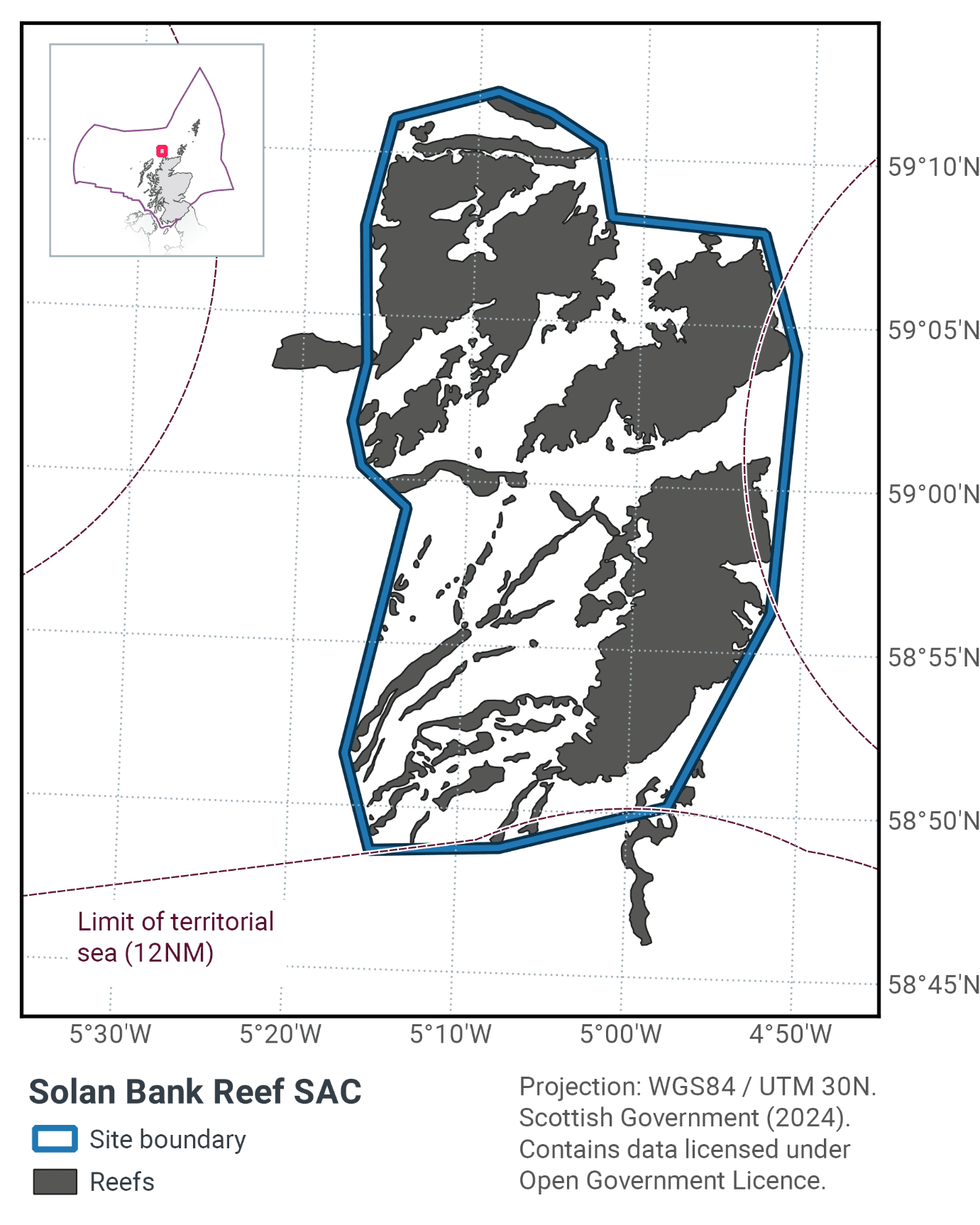
The reefs (Figure 65) are characterised by cup corals throughout, and by encrusting bryozoans and coralline algae in the shallower areas. Brittlestars are common on both the bedrock and stony reef. The highly scoured reef is mainly colonised by the keel worm Spirobranchus triqueter while a range of sponges, bryozoans and hydroids occur on less scoured reef areas (Whomersley et al., 2010). Water movement created by tidal streams and wave action is greater in shallower areas and here there is a higher abundance of species such as the soft coral Alcyonium digitatum, the cup coral Caryophyllia smithii and the jewel anemone Corynactis viridis. Foliose red algae and kelp grow in the shallowest locations where light penetrates the water.
Further information can be found in the Site Information Centre.
24.2 Site Features
The Solan Bank Reef SAC is designated for the following protected features:
- Stony and biogenic reef (Annex I Reefs).
Solan Bank Reef SAC is located in the Scottish Continental Shelf Regional Sea. It represents the Annex I reef subtypes hard bedrock reef and stony reef in the infralittoral, circalittoral and deep circalittoral zones. Therefore the site makes a contribution to the UK Network.
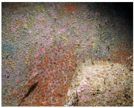
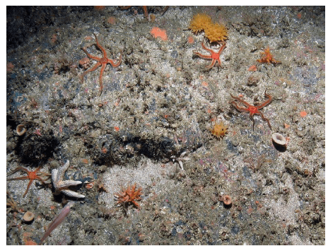
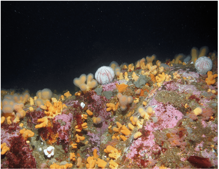
Figure 65. Feature images from Solan Bank SAC showing; a) Jewel anemones (Corynactis viridis) and encrusting coralline algae on exposed rock, b) Yellow hedgehog sponge (Polymastia boletiformis), black brittlestars (Ophiocomina nigra), branching calcareous bryozoa (Cheilostomatida) and encrusting sponges on rock with a sand veneer, and c) soft coral (Alcyonium digitatum), common sea urchin (Echinus esculentus) and encrusting coralline algae on shallow circalittoral bedrock reef © JNCC
The total area of the SAC is 856 km2, and consists of the following proportions of reef habitats shown in Table 40, which are distributed throughout the site
Reef type |
Habitat area within SAC (km2) |
|---|---|
Deep circalittoral bedrock reef |
295 |
Infralittoral bedrock reef |
0.4 |
Shallow circalittoral bedrock reef |
29 |
Stony reef |
60 |
Total |
384.4 |
24.3 Site Boundary
The site boundary for Solan Bank Reef has been defined using the JNCC marine SAC boundary definition guidelines (JNCC, 2012a). The boundary is a relatively simple polygon which includes a 300 m buffer, which is three times the maximum water depth at the site.
24.4 Conservation objectives
JNCC’s view on the overall condition of the site’s qualifying feature is uncertain due to insufficient evidence to determine the condition status.
The Conservation Objective for Solan Bank Reef is to maintain or restore the Annex I Reef at/to ‘Favourable Condition’.
The full conservation advice documents can be found on the JNCC website. This includes the formal conservation advice for the site, background information and the full conservation objectives.
24.5 Pressure from demersal mobile fishing gear
Whilst it is unlikely that demersal mobile gear can affect the long-term natural distribution of bedrock and stony reef features, there is evidence to indicate that the use of such gears can impact the structure and function of the habitat and the long term survival of its associated species.
The use of demersal mobile fishing gears is likely to cause damage or death of fragile, erect species, such as sponges and corals through abrasion, and siltration/smothering (Freese et al., 1999; Løkkeborg, 2005). Other species such as hydroids, anemones, bryozoans, tunicates and echinoderms may also be vulnerable (McConnaughey et al., 2000, Sewell & Hiscock, 2005).
Where fragile, slow growing species occur, even low levels of fishing have the potential to change the structure and function of the habitats and may result in the loss of some characteristic species.
24.6 Pressure from demersal static fishing gear
Mechanical impacts of demersal static gear (e.g. weights and anchors hitting the seabed, hauling gear over seabed, rubbing/entangling effects of ropes) can damage some species (Eno et al., 1996). Other species appear to be resilient to individual fishing operations but the effects of high fishing intensity are unknown (Eno et al., 2001). Recovery will be slow (Foden et al., 2010) resulting in significant reduction or even loss of characteristic species. The individual impact of a single fishing operation may be slight but cumulative damage may be significant (Eno et al., 2001; Foden et al., 2010).
24.7 Levels of fisheries management considered
Table 41 provides a summary of the management advice from JNCC set out against the various options that have been considered.
(Table 41) Summary of fisheries management advice for Solan Bank Reef SAC
Fisheries management options considered for demersal mobile gear
No additional management: There is a significant risk of not achieving the conservation objectives for the reef features.
Reduce / limit pressures: This level of management would reduce the risk of not achieving the conservation objectives for the reef feature. Appropriate management could include exclusion of demersal mobile gears over the main areas of bedrock and stony reef, allowing fishing to continue in fishable areas between the features. It is possible that these areas may include some areas where the distribution of reef is unknown or uncertain, and some very small areas of known Annex I reef. There would be a risk of localised damage to the structure and function of reef communities in these areas. The location of areas to be covered by management restrictions could include a buffer zone, where relevant, to further reduce any risk of accidental contact with the feature.
Remove / avoid pressures: This level of management would reduce the risk of not achieving the conservation objectives for the reef feature within the site boundary to the lowest possible levels. Restrictions would be required for all demersal mobile gears within the full extent of the site boundary.
Fisheries management options considered for demersal static gear
No additional management: This level of management is considered to be sufficient for demersal static gear to achieve the conservation objectives for the reef feature. However, if monitoring showed evidence of detrimental effects as a result of static gear activity in the future, additional management may be required.
Reduce / limit pressures: This level of management would further reduce the risk of not achieving the conservation objectives for the reef feature. If fishing activity were to rise to levels at which damage was occurring, appropriate management could include partial closure of the feature and/or limits on the amount of gear that can be deployed.
24.8 Proposed fisheries management and rationale
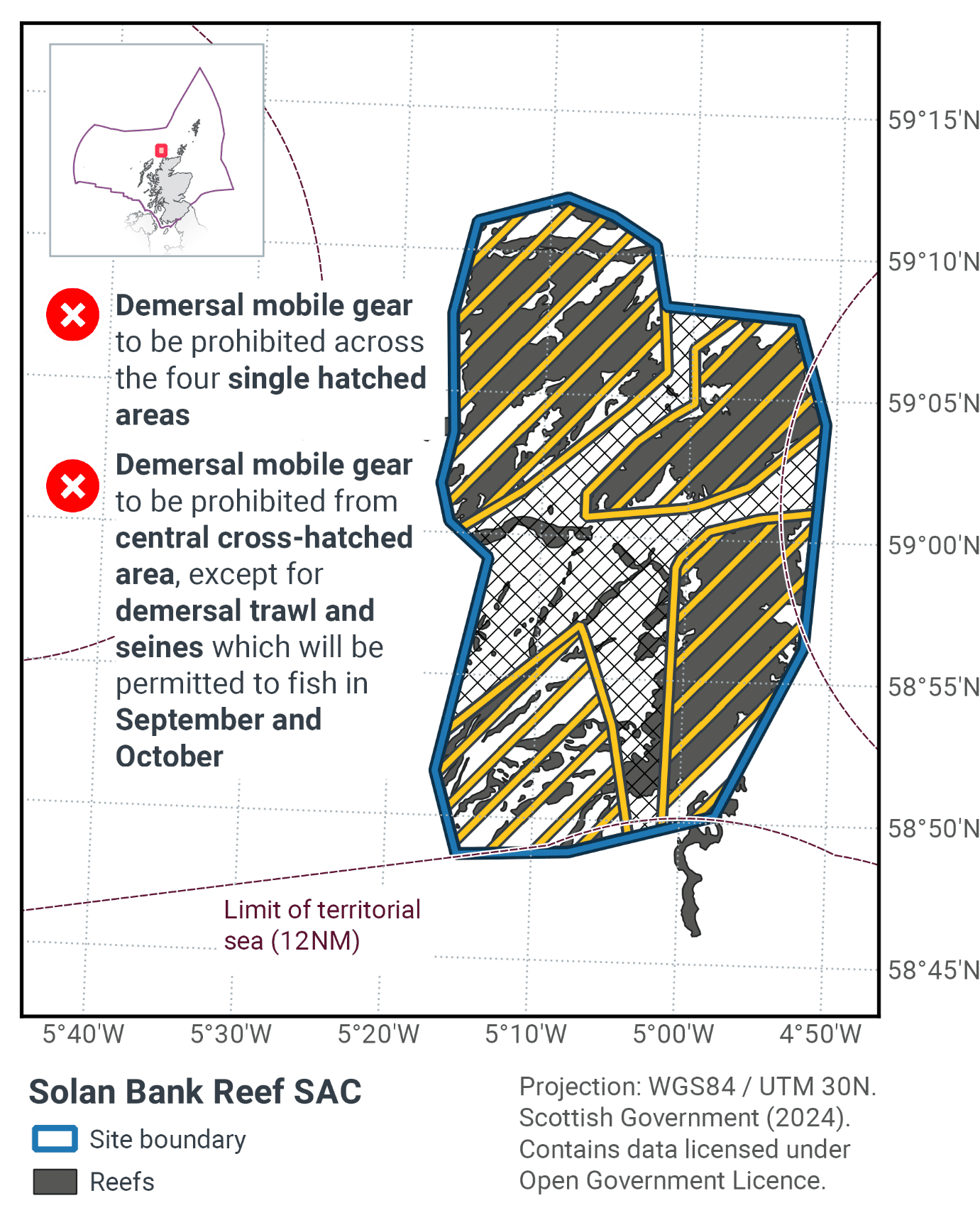
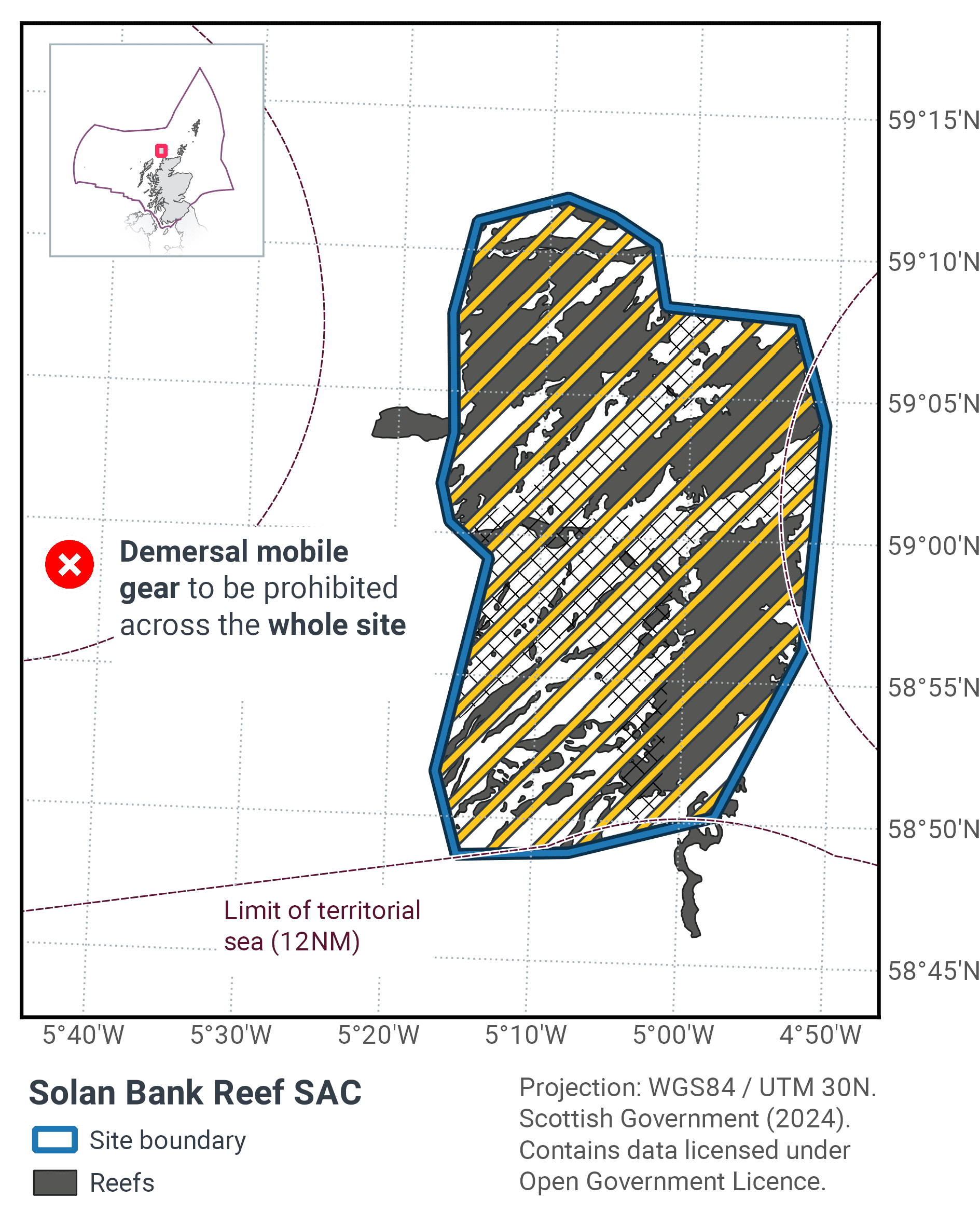
Table 42 and Figure 66 provides details of the proposed management approach and further explanation is provided below. Figure 67 shows the proposed fisheries management for full site prohibitions.
Protected feature |
Gear type |
Proposed management |
Measures |
|---|---|---|---|
Bedrock and stony reef |
Demersal mobile gear |
Reduce/limit pressure |
Prohibit activity within the Solan Bank Reef SAC, but with a zonal and temporal derogation for trawl and seine fisheries |
Demersal static gear |
No additional management |
No demersal static gear measures applied |
Temporal and spatial measures apply to the site with the full site closed to demersal mobile gears except in September and October where demersal trawls and seines will be permitted to fish a designated zone as shown in Figure 66. The zonal and temporal management arrangement is designed to enable limited trawl activity in gaps between the reef habitats, where a short but profitable haddock fishery takes place on an annual basis.
Table 43 provides details of the reef subtypes present within the SAC and the proportion of each that would be protected by the management measures. In this case 100% of reef habitat will be protected for 10 months of the year. In the other 2 months (September and October) 5.89% of bedrock reef and 26.72% of stony reef will be potentially exposed to fishing pressure from trawls and seines. In total this exposure equates to 8.13% of the total reef resource.
Reef type |
Habitat area within SAC (km2) |
% protected demersal mobile gears November – August inclusive |
Area within demersal mobile gear management zone (km2) applies September and October |
% protected demersal mobile gears September and October |
|---|---|---|---|---|
Deep circalittoral bedrock reef |
295 |
100 |
280 |
94 |
Infralittoral bedrock reef |
0.4 |
100 |
0.4 |
100 |
Shallow circalittoral bedrock reef |
29 |
100 |
29 |
99 |
Stony reef |
61 |
100 |
44 |
73 |
Total |
384.4 |
100 |
353.4 |
92 |
Contact
Email: marine_biodiversity@gov.scot
There is a problem
Thanks for your feedback