Fisheries Management Measures within Scottish Offshore Marine Protected Areas (MPAs) - Site Proposal Document
This document describes the process, justification and evidence used to develop site specific management measures. It outlines key information for each site including their features, and risks of potential pressures.
25. Stanton Banks SAC
25.1 Description and background
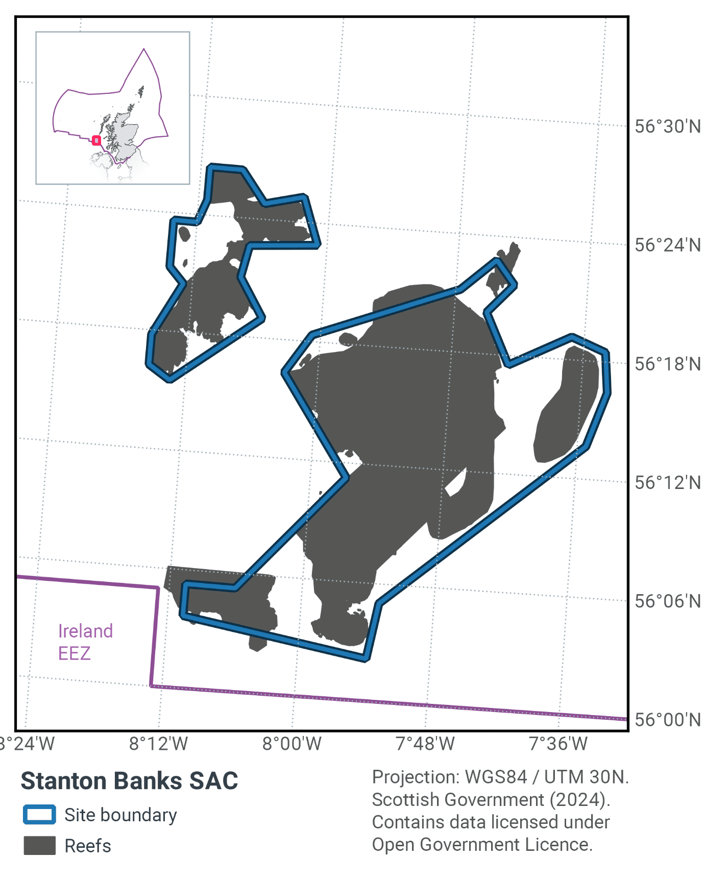
Stanton Banks SAC is located south of the Outer Hebrides, as shown in Figure 68. The Stanton Banks are a series of granite ridges up to 160 m tall that protrude from the seabed at 190 m deep.
The tops of these ridges are smooth and covered in encrusting species, such as red algae and small sponges. The inter-connecting gullies are filled with rippled coarse shell sand. The rougher sides of the ridges support species such as feather stars, dead man's fingers and hydroids. The smoother lower regions of the banks provide habitat for barnacles, brittlestars, cup-shaped sponges and massive sponges. On the edges of the ridges there are boulders and cobbles covered by coralline algae and keel worms.
More detailed site information can be found in the Site Information Centre.
25.2 Site Features
The Stanton Banks SAC is designated for the following protected features:
- Bedrock and stony reef (Annex I Reefs).
The bedrock outcrops are heavily encrusted with coralline algae, keel worms and brittlestars such as Ophiura albida, with clusters of sponges including cup-shaped axinellid sponges (Axinella infundifiliformis). On the slopes, there is a transition from smooth bedrock to fissured rock outcrops, boulders and cobbles with feather stars (Leptometra celtica), dead man's fingers (Alcyonium digitatum) and robust hydroids (Tubularia spp.). The lower circalittoral zone of the Stanton Banks SAC is characterised by smooth, silty bedrock dominated by extensive encrusting coralline red algae, numerous barnacles, brittlestars, small sponge crusts (including Hymedesmia paupertas), cup-shaped axinellid sponges (Axinella infundibuliformis) and massive sponges (Mycale lingua and Pachymatisma johnstonia). Starfish (such as Luidia ciliaris, Porania pulvillus, Crossaster papposus) and sea urchins (Echinus esculentus) are also common.
Surrounding the Annex 1 rocky reef feature, the banks are fringed with stony reef comprising of boulders and cobbles, graduating into coarse and mixed sediments. Many of the cobbles are covered by encrusting sponges (including Hymedesmia paupertas), hydroids and bryozoans. Crabs (Cancer pagarus) and squat lobsters (Galatheoidea sp.) are also present. There have been reports of cold-water coral at the site, but currently JNCC has no direct evidence to support this.
Reef type |
Habitat area within SAC (km2) |
|---|---|
Bedrock |
160 |
Bedrock and/or Stony |
317 |
Stony |
75 |
25.3 Site Boundary
The boundary for the Stanton Banks SAC has been defined using JNCC’s marine SAC boundary definition guidelines (JNCC, 2008) and information provided during public consultation on this site in 2007-2008. The proposed boundary is a complex polygon enclosing the minimum area necessary to ensure protection of the Annex I habitat. Coordinate points have been positioned as close to the edge of the interest features as possible, rather than being located at the nearest whole degree or minute point.
The proposed boundary includes a margin to allow for mobile gear on the seabed being at some distance from the location of a vessel on the sea surface. The maximum depth of water around the feature is 190m; therefore, assuming a ratio of 3:1 fishing warp length to depth, the proposed boundary is defined to include a margin of 570m from the bedrock reef. The reef habitat feature extent is drawn from interpolated data from British Geological Survey (BGS) mapped at a scale of 1:250,000 (Graham et al., 2001). Refer to Conservation Objectives and Advice on Operations documents written for Stanton Banks SAC for more detail.
25.4 Conservation objectives
JNCC’s view on the overall condition of the site’s qualifying feature is that it is in unfavourable condition and therefore needs to be restored to favourable condition.
The Conservation Objectives for the Stanton Banks SAC are for the feature to be in favourable condition thus ensuring site integrity in the long term and contribution to Favourable Conservation Status of Annex I Reefs.
This contribution would be achieved by maintaining or restoring, subject to natural change:
- The extent and distribution of the qualifying habitat in the site;
- The structure and function of the qualifying habitat in the site; and
- The supporting processes on which the qualifying habitat relies.
The full conservation advice documents can be found on the JNCC website. This includes the formal conservation advice for the site, background information and the full conservation objectives.
25.5 Pressure from demersal mobile fishing gear
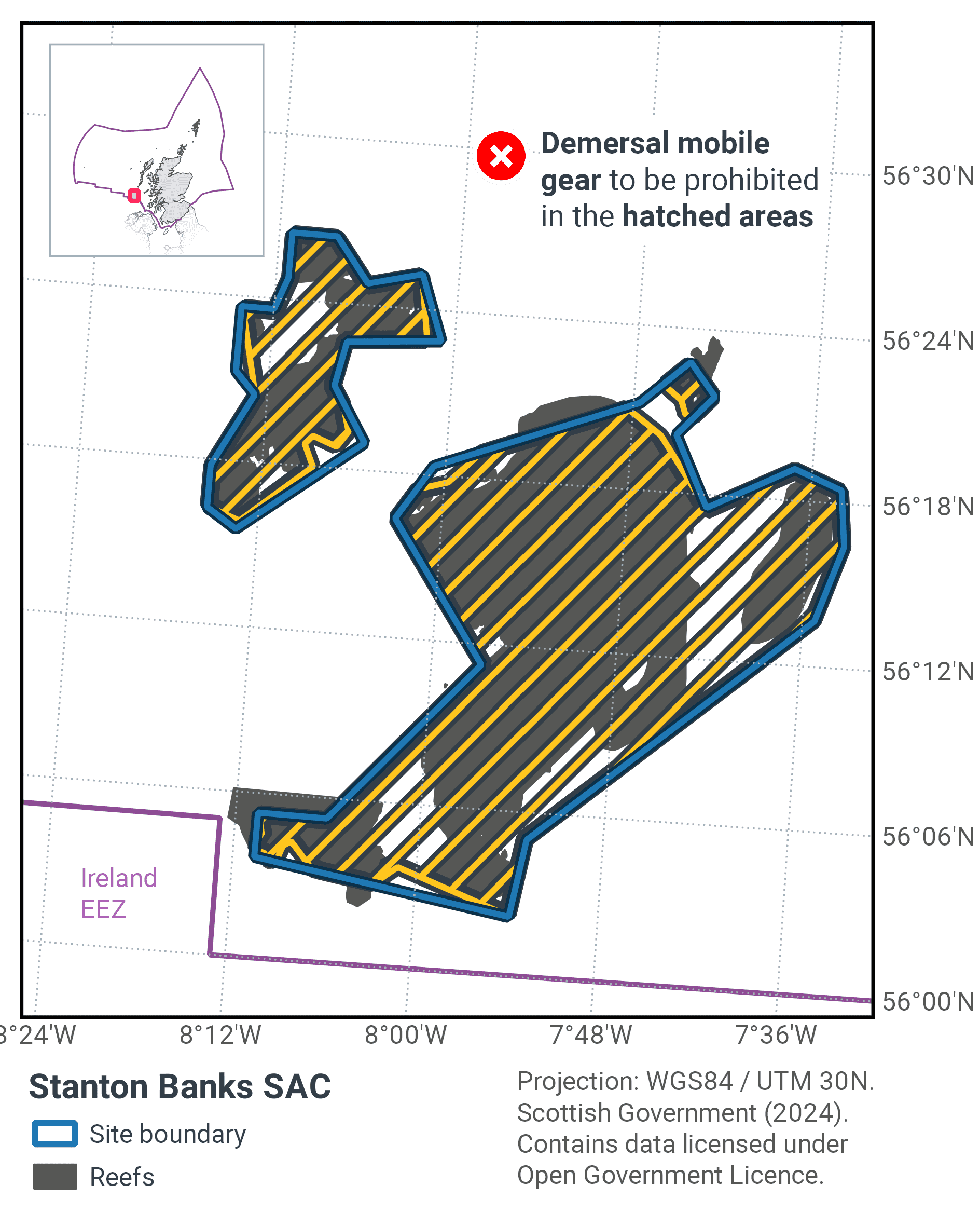
Five small areas have been identified within the site that are regularly fished by demersal trawlers targeting Nephrops norvegicus but do not contain Annex I reef features (see figure 2). It is not considered likely that fishing within these areas will have a significant effect on the Annex I features.
The remainder of the site is not currently fished by these gears but if fishing were to occur in the future, it is likely that there would be a significant effect: whilst it is unlikely that demersal mobile gears can affect the long-term natural distribution of granite bedrock reef features, there is some evidence to indicate that the use of demersal mobile gears can impact the structure and function of the habitat and the long term survival of its associated species.
The use of demersal mobile fishing gears is likely to cause damage or death of fragile, erect species, such as sponges and corals (Løkkeborg 2005, Freese et al. 1999). Other species such as hydroids, anemones, bryozoans, tunicates and echinoderms may also be vulnerable (McConnaughey et al. 2000, Sewell and Hiscock 2005). Recovery is likely to be slow (Foden et al. 2010). Where fragile, slow growing species occur, even low levels of fishing have the potential to change the structure and function of the habitats and may result in the loss of some characteristic species.
25.6 Pressure from demersal static fishing gear
Intensity of demersal static gear fishing in this site is low and it is considered unlikely that this activity poses a significant risk to the long-term natural distribution, structure and functions of the habitats or the long-term survival of associated species. If fishing intensity were to increase to high levels in the future, there is a risk of significant impact to the structure and functions of the habitats.
Mechanical impacts of demersal static gear (e.g. weights and anchors hitting the seabed, hauling gear over seabed, rubbing / entangling effect of ropes) can damage some species (Eno et al., 1996). Other species appear to be resilient to individual fishing operations but the effects of high fishing intensity are unknown (Eno et al., 2001). Recovery will be slow (Foden et al., 2010) resulting in significant reduction or even loss of characteristic species. The individual impact of a single fishing operation may be slight but cumulative damage may be significant (Eno et al., 2001, Foden et al., 2010). Sensitivity to low intensity potting is considered low (Hall et al., 2008, JNCC and Natural England, 2011).
25.7 Levels of fisheries management considered
Table 45 provides a summary of the management advice set out against the various options that have been considered.
(Table 45) Summary of fisheries management advice for Stanton Banks SAC
Fisheries management options considered for demersal mobile gear
No additional management: There is a significant risk of not achieving the conservation objectives for the reef features.
Reduce / limit pressures: This level of management would reduce the risk of not achieving the conservation objectives for the reef feature. Appropriate management could include exclusion of demersal mobile gears over the main areas of bedrock and stony reef, allowing fishing to continue in fishable areas between the features. It is possible that these areas may include some areas where the distribution of reef is unknown or uncertain, and some very small areas of known Annex I reef. There would be a risk of localised damage to the structure and function of reef communities in these areas. The location of areas to be covered by management restrictions could include a buffer zone, where relevant, to further reduce any risk of accidental contact with the feature.
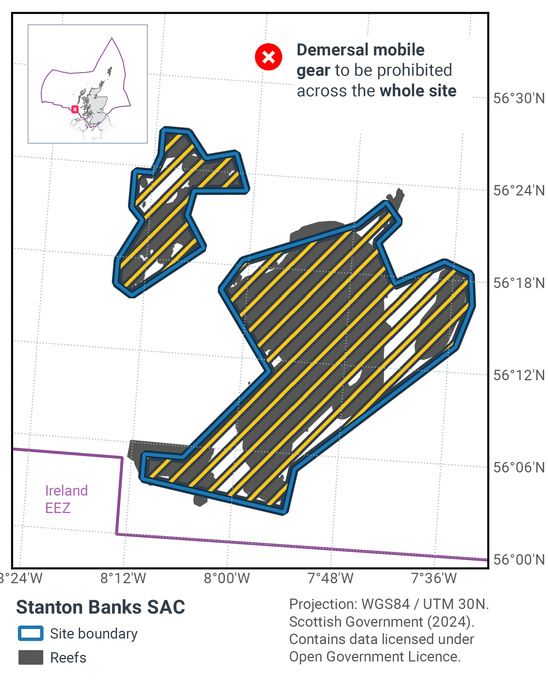
Remove / avoid pressures: This level of management would reduce the risk of not achieving the conservation objectives for the reef feature within the site boundary to the lowest possible levels. Restrictions would be required for all demersal mobile gears within the full extent of the site boundary.
Fisheries management options considered for demersal static gear
No additional management: This level of management is considered to be sufficient for demersal static gear to achieve the conservation objectives for the reef feature. However, if monitoring showed evidence of detrimental effects as a result of static gear activity in the future, additional management may be required.
Reduce / limit pressures: This level of management would further reduce the risk of not achieving the conservation objectives for the reef feature. If fishing activity were to rise to levels at which damage was occurring, appropriate management could include partial closure of the feature and/or limits on the amount of gear that can be deployed.
25.8 Proposed fisheries management and rationale
Proposed zonal measures are outlined in Table 46 and shown in Figure 69 with further explanation provided below. Proposed full site measures are outlined in Figure 70.
Protected feature |
Gear type |
Proposed management |
Measures |
|---|---|---|---|
Bedrock and stony reef |
Demersal mobile gear |
Reduce/limit pressure |
Prohibit activity across 99.71% of reef feature |
Demersal static gear |
No additional management |
No demersal static gear measures applied |
A zonal approach would be applied to the site for demersal mobile gear. Table 47 provides details of the reef subtypes present within the SAC and the proportion of each that would be protected by the management measures. In this case 99.71% of reef habitat would be protected.
Demersal fishing occurs in five small areas which are considered not likely to have a significant impact on features. In the remainder of the site towed gear can damage fragile erect species and recovery can be slow. These proposed measures protect the feature but does not impact existing trawl fisheries.
Reef type |
Total area of habitat within SAC (km2) |
Area within demersal mobile management zone (km2) |
% reef habitat protected by demersal mobile management zone |
|---|---|---|---|
Bedrock |
160 |
160 |
100% |
Bedrock and/or Stony |
317 |
316 |
99.68% |
Stony |
75 |
75 |
100% |
Total |
552 |
551 |
99.81% |
Contact
Email: marine_biodiversity@gov.scot
There is a problem
Thanks for your feedback