Fisheries Management Measures within Scottish Offshore Marine Protected Areas (MPAs) - Site Proposal Document
This document describes the process, justification and evidence used to develop site specific management measures. It outlines key information for each site including their features, and risks of potential pressures.
26. The Barra Fan and Hebrides Terrace Seamount MPA
26.1 Description and background
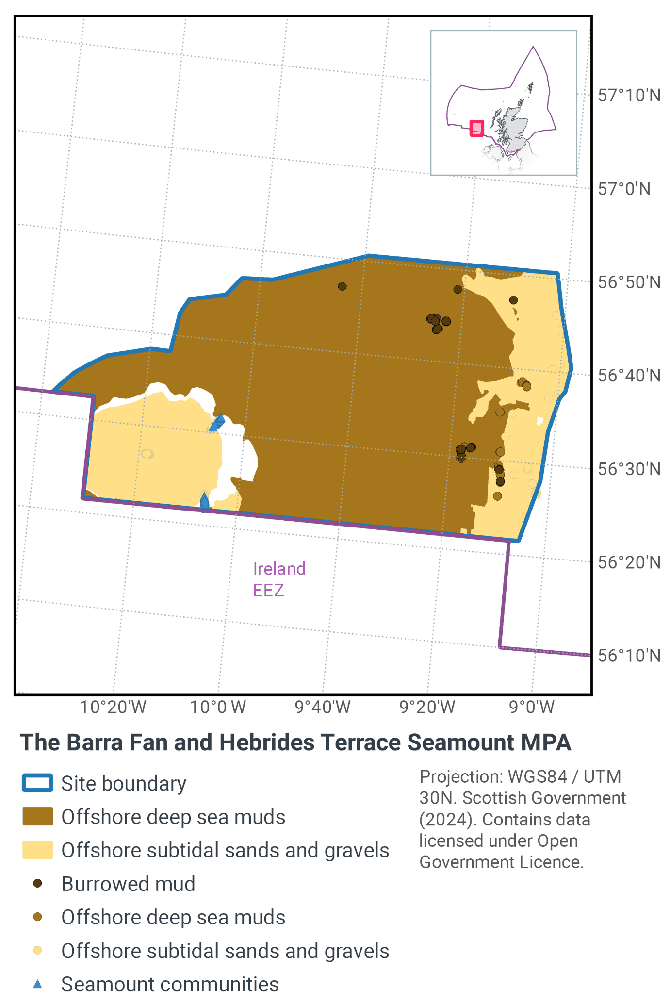
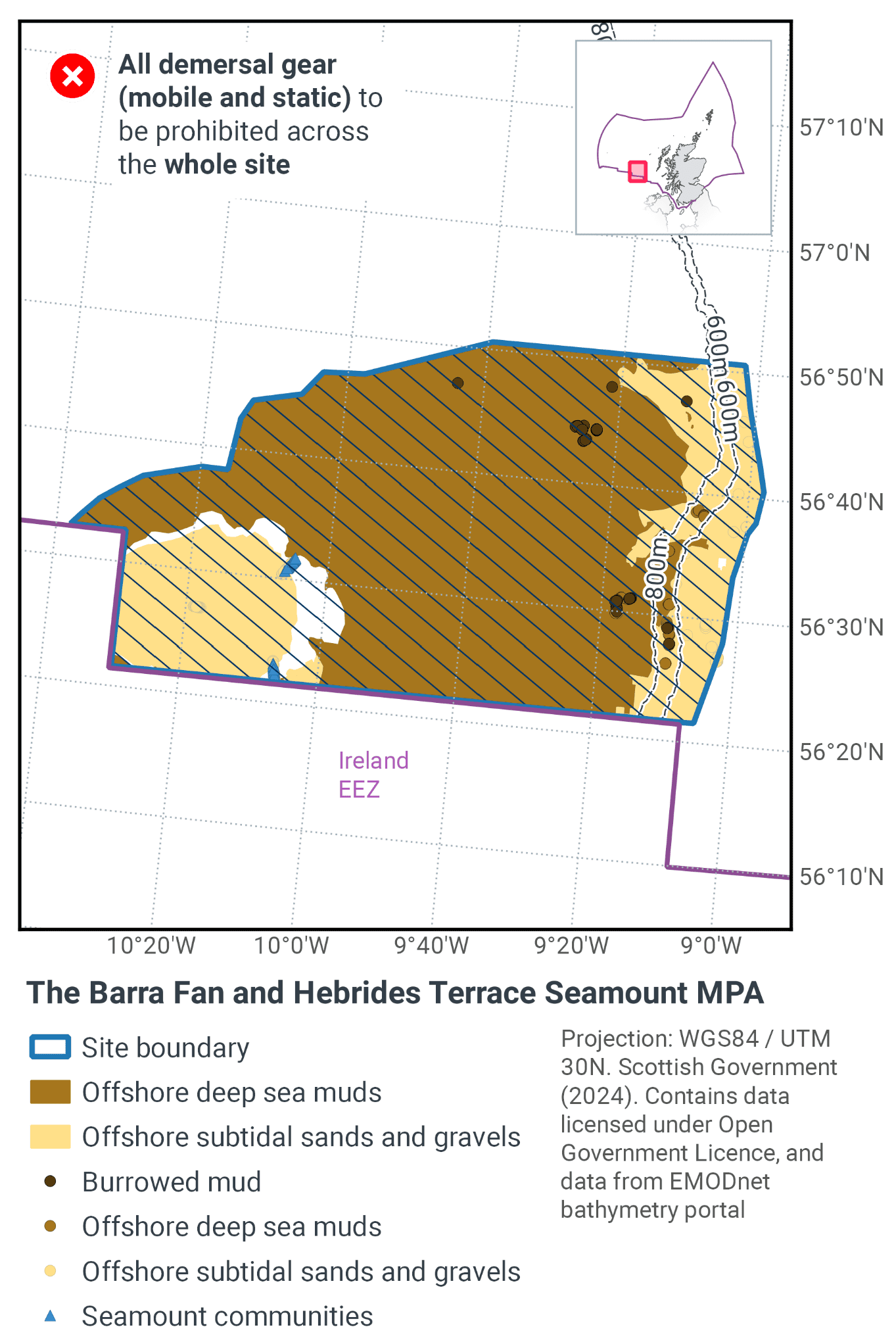
The Barra Fan and Hebrides Terrace Seamount MPA is located to the west of Scotland, as shown in Figure 71. The MPA ranges from the top of the Hebridean continental slope down into the Rockall Trough. The depth ranges around 200 m to below 2000 m and the site has an area of 4373 km2.
The continental slope captures the biological diversity of sediments that change with depth. The base of the continental slope provides conditions for the establishment of burrowed mud habitat; specifically seapens and burrowing megafauna communities. To the west of the site, the Hebrides Terrace Seamount rises to a height of almost 1 km above the surrounding seabed and is thought to represent a remnant of an ancient volcano. The seamount supports a diverse range of habitats and species including cold-water corals and deep sea sponges (Figure 72).
Further information can be found in the Site Information Centre.
26.2 Site Features
The Barra Fan and Hebrides Terrace Seamount MPA is designated for the following protected features:
- Burrowed mud (seapen and burrowing megafauna communities
- Seamount communities
- Offshore subtidal sand and gravels
- Offshore deep sea muds
- Orange roughy
- Iceberg ploughmark field, prograding wedges, continental slope turbidite canyons, slide deposits, scour moat, continental slope and Hebrides Terrace Seamount representative of The Barra Fan & The Peaches Slide Complex Key Geodiversity Areas
- Continental slope
- Seamount
All of the protected features of the site are considered to be a priority for marine conservation in Scotland’s seas and are considered appropriate for a spatial management approach.
Seapens and burrowing megafauna, orange roughy (Hoplostethus atlanticus) and seamounts are listed by the OSPAR Commission as Threatened and/or Declining. Therefore this MPA makes a significant contribution to meeting obligations under the OSPAR convention.
More information regarding the site selection process for the Barra Fan and Hebrides Terrace Seamount MPA is available in the detailed assessment against the Scottish MPA Selection Guidelines document.
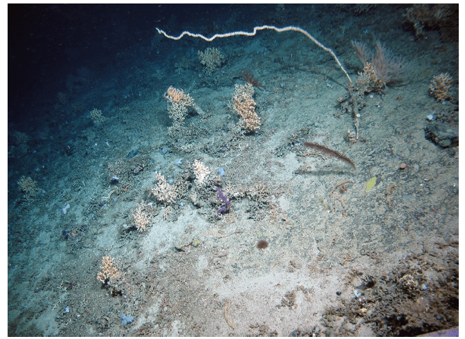
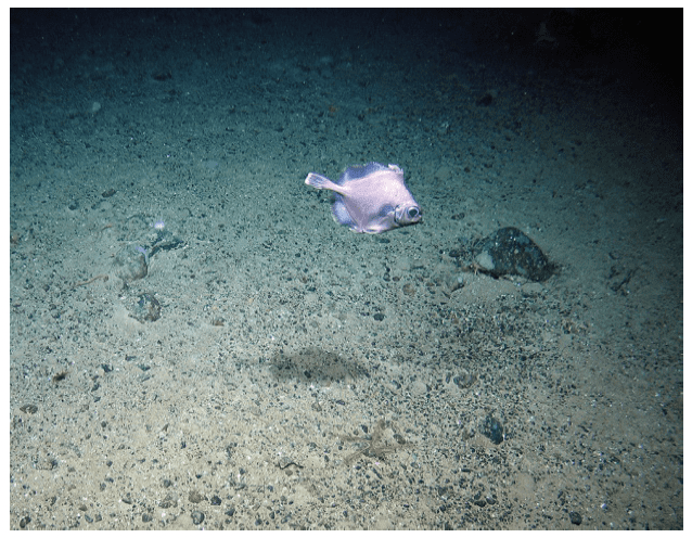
Figure 72. Examples of some of the protected features taken from the Barra Fan and Hebrides Terrace Seamount MPA, showing a) a range of coral species representing seamount communities, and b) boarfish sands and gravels ©Heriot-Watt University, JNCC and Natural Environment Research Council.
26.3 Site Boundary
The boundary has been set in accordance with the boundary setting principles outlined in the MPA Selection Guidelines.
The boundary has been drawn to capture the biological diversity of sediments that change with depth and includes all clustered records of burrowed mud and seapens. It overlaps all depth strata down the slope to provide representation of the full range of associated biological communities which are reported to vary with depth (Hughes et al., 2014).
To the west, the boundary has been drawn to encompass the full extent of The Hebrides Terrace Seamount in Scottish waters and encompasses numerous geodiversity interests including the Barra Fan and Peach Slide Complex Key Geodiversity Areas (Brooks et al., 2013).
Confidence in the presence and extent of the protected features has been set out in the Data Confidence Assessment.
26.4 Conservation objectives
JNCC’s view on the overall condition of the following site’s qualifying feature is that they are in unfavourable condition and therefore need to be restored to favourable condition. These features are:
- Burrowed mud (seapen and burrowing megafauna communities
- Seamount communities
- Offshore subtidal sand and gravels
- Offshore deep sea muds
- Orange roughy
- Iceberg ploughmark field
JNCC’s view on the overall condition of the following site’s qualifying feature is that they are in favourable condition and therefore need to be maintained at favourable condition. These features are:
- prograding wedges, continental slope turbidite canyons, slide deposits, scour moat, continental slope and Hebrides Terrace Seamount representative of The Barra Fan & The Peaches Slide Complex Key Geodiversity Areas
- Continental slope
- Seamount
The Conservation Objective for The Barra Fan Hebrides Terrace Seamount Nature Conservation Marine Protected Area is that the protected features:
- so far as already in favourable condition, remain in such condition; and
- so far as not already in favourable condition, be brought into such condition, and remain in such condition
The full conservation advice documents can be found on the JNCC website. This includes the formal conservation advice for the site, background information and the full conservation objectives.
26.5 Pressure from demersal mobile fishing gear
Studies have shown that areas of mud habitats (which include burrowed mud and offshore deep-sea mud) subject to demersal mobile fishing activity support a modified biological community with lower diversity, reduction or loss of long-lived filter-feeding species and increased abundance of opportunistic scavengers (Ball et al., 2000; Tuck et al., 1998). This effect was greatest in the more heavily fished offshore areas suggesting that impact is related to the intensity of fishing (Ball et al., 2000). Furthermore, modelling studies suggest that the greatest impact is produced by the first pass of a trawl (Hiddink et al., 2006).
Where sand and gravel sediments occur in high energy locations (i.e. of wave and/or tide exposed) the associated fauna tend to be well adapted to disturbance and as a result are more tolerant of fishing-related disturbance (Dernie et al., 2003; Hiddink et al., 2006). However, in lower energy deep water locations such as The Barra Fan and the Hebrides Terrace Seamount MPA, sediments tend to be more stable and their associated fauna less tolerant of disturbance (Hiddink et al., 2006; Kaiser et al., 2006). Stable gravels often support a ‘turf’ of fragile species which are easily damaged by trawling and recover slowly (Collie et al., 2005; Foden et al., 2010).
Trawling and dredging tend to cause increased mortality of fragile and long lived species and favour opportunistic, disturbance-tolerant species (Eleftheriou & Robertson, 1992; Bergman & van Santbrink, 2000). Some particularly sensitive species may disappear entirely (Bergman & van Santbrink, 2000). The net result is benthic communities modified to varying degrees relative to the un-impacted state (Bergman & van Santbrink, 2000; Kaiser et al., 2006).
The species associated with seamount communities tend to be composed of erect and fragile species that are sensitive to physical disturbance, particularly deep-sea stony corals, gorgonians, black corals, sea anemones, hydroids and sponges (Clark & Tittensor, 2010; Clark et al., 2010).
Trawling can cause mortality to species by disturbance on the seabed or by bringing them to the surface resulting in a reduction in abundance (Kaiser et al., 1996; Jennings & Kaiser, 2008; ICES, 2010). Recovery from such damage is estimated to be measured in decades, depending on the environmental conditions (Clark et al., 2010; ICES, 2010).
In the 1990s, a targeted demersal otter trawl fishery for orange roughy occurred in deep water west of Scotland. However, in recent years, a zero Total Allowable Catch (TAC) was implemented for orange roughy in ICES Division area VI, which has effectively ended the fishery in this region.
26.6 Pressure from demersal static fishing gear
Only the seamount communities feature within the Barra Fan and Hebrides Terrace Seamount MPA is considered to be sensitive to demersal static gear. No studies providing evidence of the effects of static gears on Scottish seamounts were found, however impacts occurring on analogous vulnerable habitats and species, such as sponges and corals in Scottish waters are applicable (Muñoz et al., 2010). Impacts can arise from hooks, lines, nets and ropes becoming entangled with corals and other fragile species, including ‘plucking’ them from the seabed during hauling (Mortensen et al., 2005; Muñoz et al., 2010; OSPAR, 2010b). While the extent of damage caused by individual static gear fishing events is likely to be lower than that for trawling (Pham et al., 2014), the effect of cumulative damage may be significant.
26.7 Levels of fisheries management considered
Table 48 provides a summary of the management advice set out against the various options that have been considered.
(Table 48) Summary of fisheries management measures for the Barra Fan and Hebrides Terrace Seamount MPA
Fisheries management options considered for demersal mobile gear
No additional management: There is a risk of not achieving the conservation objectives for burrowed mud, offshore deep sea muds and offshore subtidal sands and gravels. The conservation objective would not be achieved for seamount communities and JNCC recommend that this level of management should not be applied for this feature.
Reduce / limit pressures: This level of management would reduce, but not entirely eliminate, the risk of not achieving the conservation objectives for burrowed mud, offshore deep sea muds and offshore subtidal sands and gravels. Appropriate management could include restrictions on fishing with damaging gears over a proportion of the extent of each of these features, and there may be a greater requirement for restrictions on gears that penetrate deeply into the sediment. If applied to the steep flanks of the seamount feature between depths where seamount communities are known to occur, This level of management would reduce, but not entirely eliminate the risk of seamount communities not achieving their conservation objectives.
Remove / avoid pressures: This level of management would reduce the risk of not achieving the conservation objectives for burrowed mud, offshore deep sea muds, and offshore subtidal sands and gravels to the lowest possible levels. This level of management would reduce the risk of the seamount communities feature not achieving its conservation objective to the lowest possible level. JNCC recommend that this level of management should be applied to the entirety of the seamount feature in Scottish waters.
Fisheries management options considered for demersal static gear
No additional management: This level of management is considered to be sufficient for demersal static gear to achieve the conservation objectives for burrowed mud, offshore deep sea muds, and offshore subtidal sands and gravels. However, the conservation objective would not be achieved for seamount communities.
Reduce / limit pressure: The conservation objective would not be achieved for seamount communities.
Remove / avoid pressures: This is the only option that would achieve the conservation objective for seamount communities and JNCC recommend that this level of management should be applied where this feature is present.
26.8 Other fisheries measures which apply to the site
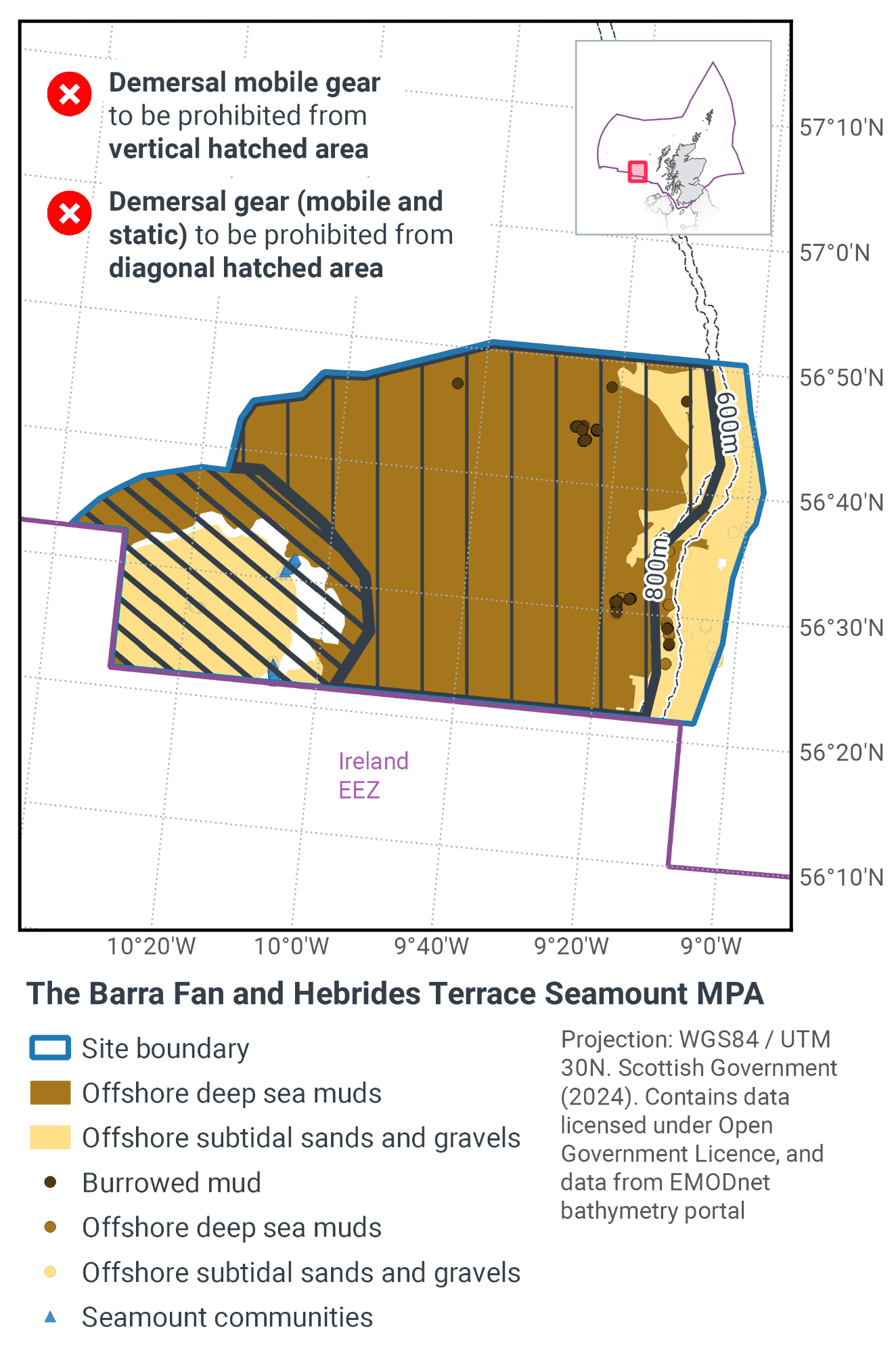
Part of this proposal is to prohibit trawling in waters greater than 800 m depth, this measures has been encompassed in the new EU-wide Deep Sea Fisheries Regulation ((EU) 2016/2336). This came into force in January 2017 and was transposed into UK legislation via The Common Fisheries Policy and Aquaculture (Amendment etc.) (EU Exit) Statutory Instrument (S.I.) 2019 No. 753.
Regulation (EU) 2019/1241 prohibits the deployment of any bottom-set gillnets, trammel nets and entangling nets where the chartered water depth is deeper than 600m to protect fish stocks, this applies to a substantial portion of this site making a contribution to furthering the conservation objectives of the site. There is only a small area at the top of the seamount where depth is less than 600 m, however the proposed management measures will prohibit demersal static (and demersal mobile) gears from this area.
26.9 Proposed fisheries management and rationale
Table 49 and Figure 73 provide details of the proposed management approach and further explanation is provided below. Figure 74 shows the proposed fisheries management for full site prohibitions.
Protected feature |
Gear type |
Proposed management |
Measures |
|---|---|---|---|
Seamount communities |
Demersal mobile gears |
Remove / avoid pressures |
Exclusion of all demersal mobile gears from the entirety of the Hebrides Terrace seamount where the feature occurs. |
Demersal static gears |
Remove / avoid pressures |
Exclusion of all demersal static gears from the entirety of the Hebrides Terrace seamount where the feature occurs. |
|
Offshore sands and gravels, Deep sea muds, Burrowed mud |
Demersal mobile gear |
Reduce / limit pressure |
Zonal exclusion of demersal mobile gears from depths greater than 800 m. |
Seamount communities are amongst the most sensitive habitats to the impacts of fishing gears. Therefore, excluding demersal mobile and demersal static gears from the full extent of the Hebrides Terrace seamount is the only approach that will further the conservation objectives for the seamount communities feature within the MPA.
For the sedimentary habitats the management boundary for demersal mobile gears has been drawn on the 800 m contour. In waters deeper than 800 m the collateral damage to vulnerable species exceeds the commercial return from trawl fisheries (Clarke et al., 2015). Therefore, continued trawl activity below that depth would not be considered a sustainable use of the MPA.
The measures will contribute to the recovery of the OSPAR listed Threatened and/or Declining habitats coral gardens, seamount communities, and orange roughy. They should also further progress towards Good Environmental Status in the Celtic Seas, particularly in relation to Descriptors 1 (biological diversity) and 6 (sea-floor integrity).
Contact
Email: marine_biodiversity@gov.scot
There is a problem
Thanks for your feedback